
For our latest Mizen Magic post, we look in detail at an area we have skipped through previously: it deserves to be more thoroughly explored as it’s rich in history but is also, literally, a backwater which rests in a time-warp. Whenever we reconnoitre the shores of Croagh Bay, I’m always taken back to the sixteenth and seventeenth centuries and to the pirates, knights and Earls who made their own little empires in this now remote district. I should probably add that I can’t find an origin or meaning for the name Croagh. But I do know that it is pronounced locally as Crew. It’s even spelt Crewe on some maps (but – late edit – have a look at the enlightening comment by ‘Tash’ at the end of this post). The following image shows a clapper bridge – possibly quite ancient: a modern concrete parapet has been placed over the much earlier stonework:

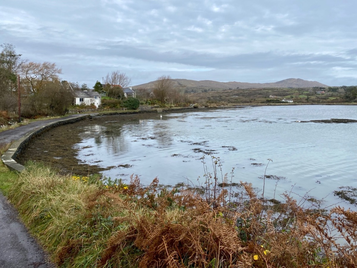
The header image and the one above are both taken at the same place – the head of the tidal section of the Croagh River, in the townland of Lowertown, not too far west of Schull. It’s rewarding to walk on the boreen that follows the north shore of the river. You will admire some very fine residences and come across tiny quays that have doubtless faithfully served many generations of West Cork families, and which are still in use. Behind you the rugged peak of Mount Gabriel will always be in sight – a familiar local landmark.


The Croagh River is only one of the waterways that you will explore today. The boreen comes to an end but the inlet itself continues out to Long Island Sound, Roaringwater Bay and the mighty Atlantic. Before that, however, there is another which demands attention: The Creek – which goes west towards the settlement of Leamcon.


Upper – an overview of the area covered by this post; centre – looking out over the Croagh River towards Long Island with the high ground above Baltimore in the far distance; lower – Croagh Bay is in the centre with Long Island beyond and Cony Island to the left
The aerial view gives a very good idea of why this particular location was so strategically important: the river estuary and the creek are both hidden out of sight of the main seafaring routes of Long Island Sound and beyond. They are, therefore, perfect safe havens for pirates, smugglers, and those who want to profit from such activities. One well-known profiteer we have encountered before in this Journal is William Hull, described in the High Court of Admiralty papers as ‘a notorious harboro of pirates and receavor of theire goodes’ who nevertheless managed to retain an official post as Deputy Vice Admiral of Munster. In cahoots with Richard Boyle – First Earl of Cork – Hull developed links with privateers and pirates, and hosted a whole fleet of vessels within the hidden inlets of Croagh Bay and Leamcon: the shallow waters were ideal for careening vessels and Hull’s empire allegedly included victualling stations, fish palaces, ale houses and brothels. All this was focussed on the townland of Leamcon which Hull leased initially from the O’Mahony Gaelic overlords. Although Hull’s own castle is now long vanished, we can find traces of his endeavours marked on the early OS maps.

The early 6″ map locates ‘Turret’, ‘Old Battery’ and ‘Site of Leamcon Old House’ within the environs of the present Leamcon House, to the north of the furthest limit of The Creek. Interestingly, there is also what looks like a quay on the water directly below the estate: all these potential antiquities could reasonably date from Hull’s time.


The ‘Battery’, the site of an old wharf and an ancient stone gulley may date from the time of William Hull’s occupation of the townland of Leamcon, which came to an end in 1641, when the O’Mahony’s moved to regain their former holdings. Below is Leamcon House today, looking down to the waters of The Creek. The extensive stone wall on the right hand side of the image is said to incorporate the remnants of a fish palace – another enterprise of William Hull and Richard Boyle:


Centre – extract from the 1612 map (see more on this here), showing Leamcon and Croagh Bay; lower – locating the Bay in relation to the islands of West Cork, from a later 6″ OS map
Before we complete our tour of Croagh Bay we have to travel east along the Croagh peninsula, where we find the intriguingly named Gun Point. There is no sign of a gun there today, nor any record of where the name might have originated. It could be, of course, that in Hull’s time the entrance to these important inlets was guarded.


We were pleased to find a briar still in bloom, but were also intrigued by this gate, above, at the very tip of Gun Point. It was singing to us! The wind which, by late afternoon, had become a bit of a gale, was picked up by the hollow metal rails and created for us a Port na bPucai – ‘song of the spirits’. We recorded it as best we could and then handed it over to our musical friend Paul Hadland. He in turn passed it on to his brother Tony – an electronics wizard, who presented us with the following rendition of our Harmonic Gate. Many thanks, Hadlands!
For the technically minded amongst you, here is Tony’s account of how he processed our recording:
. . . I first of all manually edited out the worst of the very short but irritating wind noise elements. I then traced the frequency band where the music was and applied the Apple AU Bandpass filter, centred on 400 HZ. I trimmed off the ragged beginning, faded out the end, and normalised the volume to -10db. To get rid of more of the background noise I then applied the Acon DeNoise 2 adaptive filter, using its default broadband music setting. The result is the attached file Gate Harmonics . . .
Tony Hadland, November 2020


Thank you for this fascinating historical account of Crewe Bay a place I have been familiar with for more years than I care to admit to! The house beside the bridge on the photo was owned by Sis Driscoll. My siblings and I spent hours there with little fishing nets and jam jars “fishing” The boat called The Shamrock was pretty well intact in my youth and we would sit in it and play sailors. At the end of the little road which is pictured was my grandmother’s home , the home of the Barnett family.-Another house beside that house is one which belonged to Jack Daly. This house is falling to ruin now. I return to this area every year and was most interested to read the history of the area. I did know that years ago there was a village on Richie Kingston’s land ànd there is a children’s grave yard in the area too.
LikeLiked by 1 person
Thank you for getting in touch, Máire. I’m always pleased to build up a picture of a place based on local knowledge: it’s by far the best way!
LikeLike
During the summer I explored there on my bicycle and with the OS map. Reading about the history, and enjoying your photos and the maps brings back lovely memories of that sunny day.
LikeLiked by 1 person
Thank you! Lovely memories are wonderful!
LikeLike
Loved the singing gate!
LikeLiked by 1 person
It is an individualist!
LikeLike
Thank you for that. Super interesting. I live practically next door to Leamcon House, just east, on land that was originally Hull land. Local word has it that there was a settlement here where Hull kept his ‘fancy women’. From my house, as the sun goes down I can see almost perfectly circular raised earthworks just above the creek. I often wonder what that is. I’d love a copy of that old OS map. Any ideas where I could find it would be much appreciated.
LikeLiked by 1 person
A fascinating place to live, Caroline, with all that history around you! I have emailed an extract from the 6″ OS (early 19th century).
LikeLike
Another most enjoyable post Robert, thank you. In the 1970s I was toying with buying a ruined cottage in the high ground overlooking the Creek but nothing came of it and I ended up buying a couple of wind-blasted fields in Rossbrin instead and therein lies a long tale !
LikeLiked by 1 person
Thank you, Julian. You are a Roaringwater Journal enthusiast! (and a participant…)
LikeLike
Isn’t it wonderful that there are still so many places to explore!
LikeLiked by 1 person
Yes, Amanda – although we are finding it difficult to keep everything within the 5km limit. However, we are allowed to travel to the shops (all more than 5km away!) and can legitimately explore en route.
LikeLike
Fascinating information. That area must have benn so different from today. We pass a singing gate on our daily walking route – a cut-out in the metal tube post acts like a flute and creates harmonics in the long tube.
LikeLiked by 1 person
We should get our gates together and form an ensemble!
LikeLike
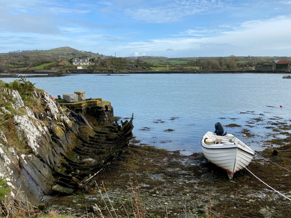
The wreck in photo seven is the Shamrock, one of the original Mackerel Yawls. They were the smaller vessels that took over from the Dandies and Nobbies such as the Flying Foam. Liam Hegarty took the lines from it and it was used to build four replica Mackerel Yawls, Shamrock II (now Noble Shamrock, Cork Harbour), An Run (built and still owned by Nigel Towse, Sherkin), Macalla (back in the ownership of Hegarty’s boatyard) and An t-Iascaire (sailing out of Baltimore).
The re-creation of the Mackerel yawls really kick started the traditional boat revival in west Cork.
Here is how she looked 20 odd years ago. https://ilur.tumblr.com/post/34232600908/here-is-a-picture-of-the-remains-of-shamrock-an
LikeLiked by 1 person
That’s excellent, Tim. Normally we would knock on doors to get valuable local lore (not always factual but invariably entertaining!), but we can’t do that in these Covid times. Your account – and the pic – are invaluable additions to the post: many thanks. For those who may not remember, I wrote about the Flying Foam, now lying under the waters of Rossbrin Cove, a while ago:
https://roaringwaterjournal.com/2019/03/02/flying-foam/
LikeLike
Wonderful sound! Thank you for sharing, along with the history and photos.
LikeLiked by 1 person
Thank you, Alice. There are so many ‘stories’ everywhere in Ireland. The Gate Music was a bonus!
LikeLike
Another fascinating post. Thank you.
The townland name there is An Chruach, which would be pronounced much more like Crewe than Crow.
It can mean stack or heap or hill/mountain. But also means steel, as derived from crua, meaning hard.
https://www.logainm.ie/ga/13526
LikeLiked by 1 person
Many thanks, Tash. I didn’t look beyond the English spelling ‘Croagh’ on the early 6″ OS map. I now see that it is An Chruach in Irish, as you say. https://www.teanglann.ie/en/fgb/cruach gives a whole stack of meanings for the word, the first being – well – ‘stack’, as you also say. This would be as in ‘a stack of corn or hay’. Another meaning – ‘hill or mountain’ – is not borne out by the terrain in this townland, which is quite low-lying. And as for steel…? Certainly an enigma: I’d like to get some local opinions on the matter. As to pronunciation, Croagh Patrick – the ‘Reek’ or holy hill in Co Mayo is usually spoken of as ‘Crow’ Patrick. But here in Cork ‘Croagh’ is ‘Crew’. Hopefully this might all lead to further discussion.
LikeLike