A Map of the County of Cork, Part 2

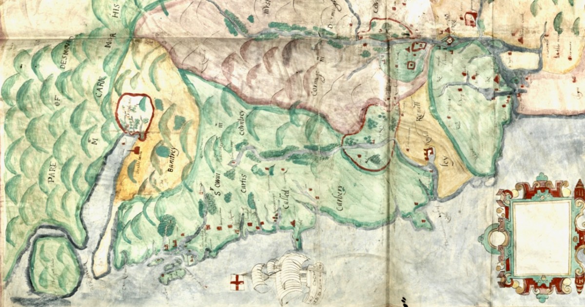
In Part 1, I said that We don’t know who did this one, or when: The date is given as 1560-1620. It seems in some ways more basic than other maps of the period, and less exact. I have now gone to the Atlas itself in Trinity College and discovered that the maps in the Digital Repository are an incomplete set. Specifically, the original Atlas at TCD contains the reverse side, the ‘verso’ of each map. Here’s what’s on the verso of the County of Cork. This:

and this:

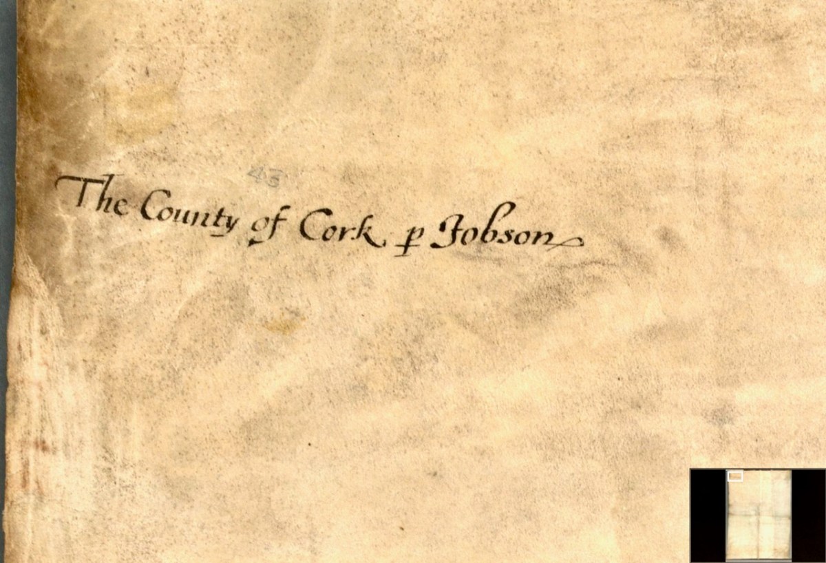
So we see that the map is attributed to our old friend Jobson – he who drew the plantation map I wrote about here and here and which was dated to 1589. There are similarities and differences between this map and that one – the galleons and scales for example look very alike. But there’s a lot more information on the plantation map and some of it is different from our Map of the County of Cork. As to the date of the County of Cork map – we will try in this post to see if we can narrow that down a bit from the broad estimate of 1560-1620. 

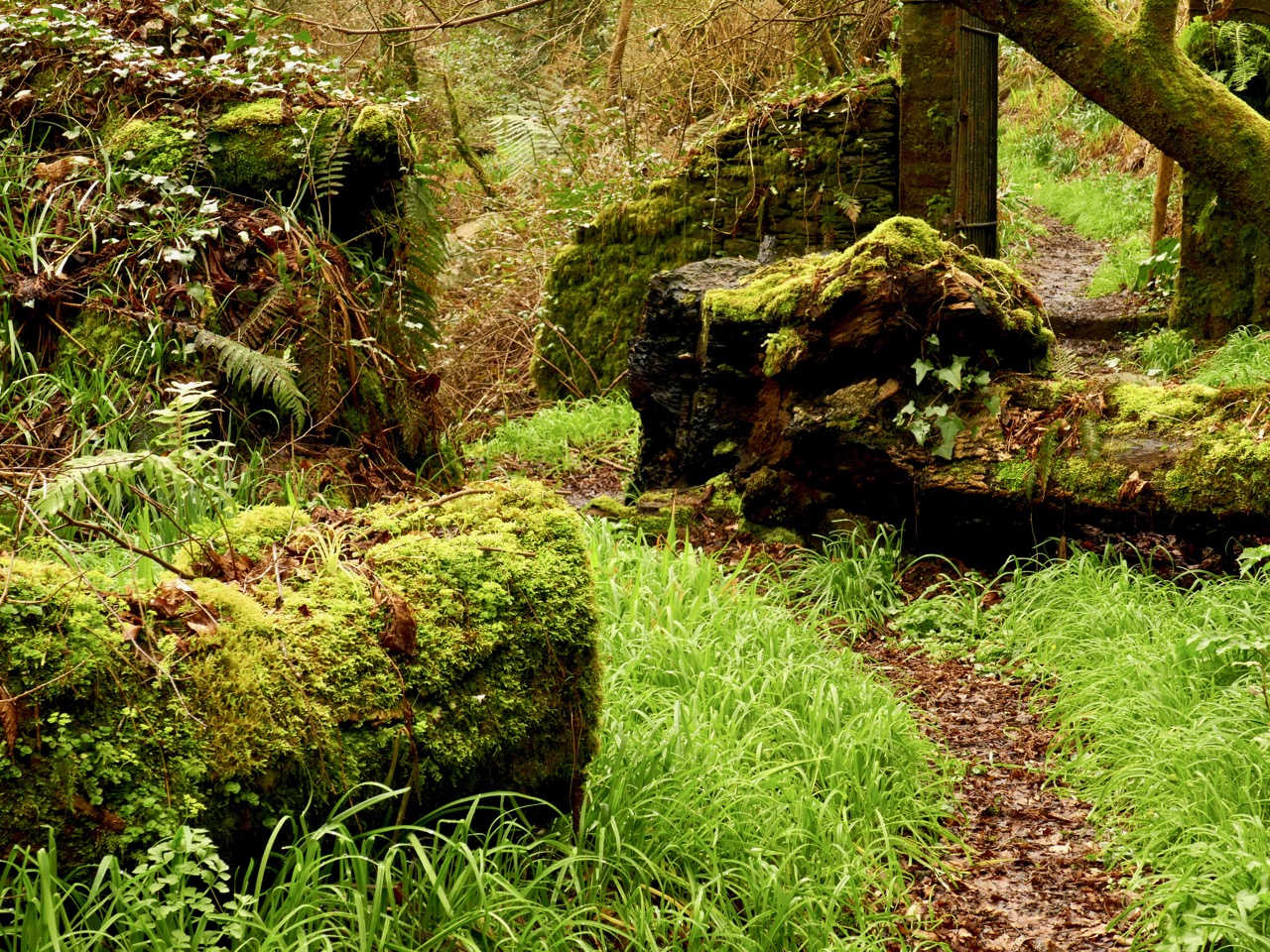
I want to go, as they say in Ireland, east along. That is, take off from where I finished last time, and travel east along the coast towards Cork, taking in the River Bandon. For the rest of this post, I’m keeping the map oriented as it is originally – that is, with west at the top (it’s actually surprising how quickly you can get used to this). Between Baltimore (Donashad) and Castlehaven (C haven), there are three castles shown, one labelled Sir Jmes Castell, Doneygodman and C skarthe. These are all a bit of a puzzle and I would invite readers to contribute ideas. On the archaeological list of Monuments for this area we can identify the O’Driscoll Castle on the Island in Lough Ine – could this be the Sir Jmes Castell? A promontory fort on Toe Head, known now as Dooneendermotmore, although likely originally an iron age refuge, was refortified in the 16th century and may, like the one I wrote about in Dunworley, have had a significant curtain wall. Was this Doneygodeman? It seems unlikely, as Doneygodeman is show inland – I wonder if instead it could be the castle at Raheen, which was a castle of the O’Donovans.

Finally, C skarthe might be a castle of the McCarthy’s – McCarthy is spelled in a variety of ways on this map, but there I can find no trace of it now. There was a castle in Listarkin, but once again, this is in the wrong place, unless this map, while certainly approximate in places, is wildly inaccurate. It seems reasonable to conclude that the more inland castles may have been harder to plot on a map that the coastal ones.

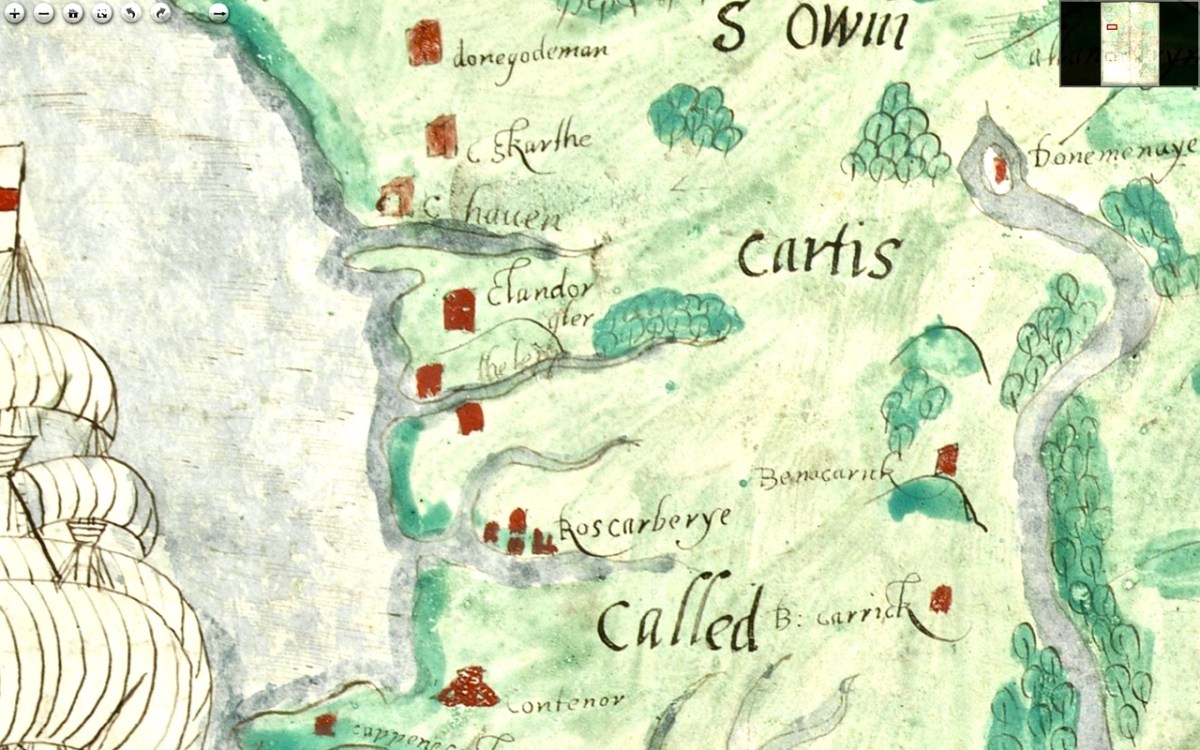
The castle at Glandore (c Landorgter) is clearly shown, along with two castles guarding the entrance to a long inlet labelled ‘the lepp.’ One may have been Kilfinnan, actually located near Glandore, which the other could possible be the coastal tower house at Downeen. This brings us to Rosscarbery (Roscarberye), shown as a collection of Buildings, as befits its status as a substantial town with a cathedral and a college, and a place of pilgrimage in the name of St Fachtna.

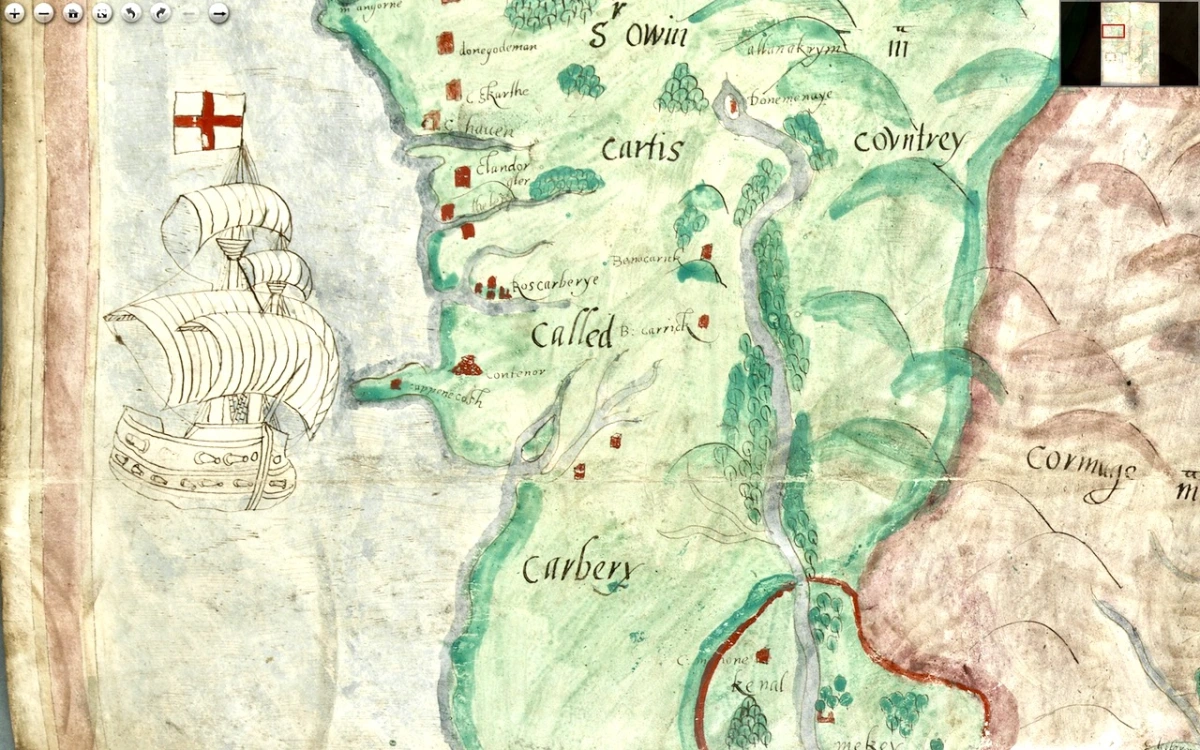
The entirety of this area, in green, is identified as Sir Owin Mc Cartis Countrey Called Carbery. Several other castles are identified here and there, and the course of the River Bandon is traced. The southernmost area is identified as Kenal Mekey, and to the south of the green-shaded section is Kennal Ley. In Canon O’Mahony’s magisterial History of the O’Mahony septs of Kinelmeky and Ivagha he states: 

In the history of South Munster there is no fact attested by more abundant evidence (evidence unknown to Smith and Gibson) than that the Sept-land of the Ui Eachach Mumhan during many centuries extended from Cork to the Mizen Head, as one continuous territory, including Kinelea and Muskerry, and was ruled by a chief whose principal residence was Rath Rathleann, in Kinelmeky.


https://archive.org/details/historyofomahony00omah/page/n1/mode/2up  Page 105

He identifies Rath Rathleann as the mighty multi-vallate ringfort of Gurranes, which was superseded by Castle Mahon, which stood where Bandon is now situated. And here it is, Kinelmeky, with C Mahon shown beside the river. Castle Mahon was later incorporated into Castle Bernard, home of Lords Bandon. Another Castle is shown further down the river – no doubt the one we are familiar with as we travel the N71.

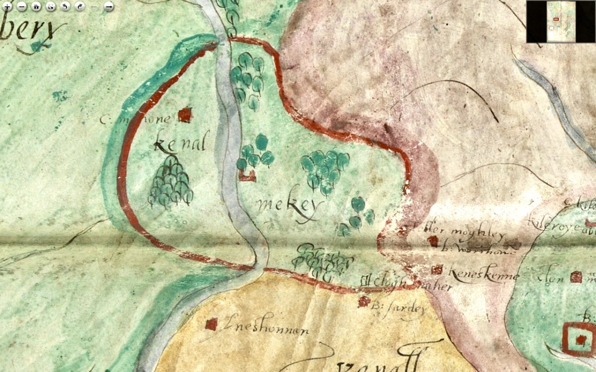
We know that all this land was acquired by Richard Boyle after the Battle of Kinsale (1601) and that he started on his walled town of Bandon Bridge around 1620. Since this is still clearly identified as O’Mahony Territory I think we can take it that this map dates to before the battle of Kinsale.

We see Kenall Ley (Kinelea) in yellow, with the walled town of Kinsale at its heart. Kinsale walls were begun around 1380 and lasted until most of them were destroyed around 1690 by the forces of William of Orange. Inishannon is noted in Kinelea, as well as Park Castell (in what is now the townland of Castlelands) and finally B: Sardey (or is that a different first letter?). We know from another map in the Hardiman Atlas (below) that B designated a small town. Given that Kinsale is such a prominent walled town on this map, once again, a date before 1601 is likely. 

Supporting a pre-1600 date is the fact that it is the old Irish families that are identified with their territories – no settler or Plantation names are given. In fact the O’Mahonys and McCarthys are the only names on the sections of the map we have seen so far. Moreover, it it really was the work of Jobson, we know he was actively mapping in 1589.

In Part 3 I’ll do a quick meander through the most interesting parts of the rest of the map. Stay tuned.

A Map of the County of Cork, Part 1

A Map of the County of Cork, Part 3

Gliding Through Velvet, Fireworks All Around

It was a magical experience – kayaking at night on Castlehaven Inlet!

Wait – what? At night? Yes – of course kayaking in West Cork is wonderful at any time but at night it takes on a special aura, helped out by the silky darkness and the silence. I went with Atlantic Sea Kayaking, the company run by the genial Jim Kennedy. I’d been with him once before, on Lough Hyne – that was way back in 2014 and was one of the highlights of my year. I wrote about that incredible trip in Starlight Bliss. This trip was equally as amazing.

We gathered at 7 at Reen Pier in Castlehaven Inlet. This is a very professional outfit – we were all shapes and sizes but soon everyone was kitted out in waterproof trousers and jackets. Then it was time for a quick lesson on how to hold the paddle and what not to do, reassurance on how stable and safe the kayaks are, and before we knew it there we were gently floating in the gathering gloaming.

Lucky me got to sit in the front of Declan Power’s kayak. He was one of our two guides and has years of experience doing this, but it doesn’t seemed to have dimmed his enjoyment and wonder. If I hadn’t already been excited, I would have been infected by his own contagious enthusiasm. It was still fairly light so we paddled down to Castletownshend, getting used to the paddles and the kayaks and our eyes adjusting to the fading light. Rosie, the other guide, brought up the rear and made sure were were all accounted for.

Declan knows his history and as we rafted up alongside Castletownsend Castle he told us about the area and about the families that had moved here after Cromwell. It’s a very special village, with interesting architecture, famous families, and, crowning glory, Harry Clarke windows in St Barrahane’s Church of Ireland. That’s his St Barrahane, below.

By now it was getting properly dark. Declan and Rosie turned on their helmet lights and we headed back up the inlet. We steered towards the far bank, where overhanging trees blocked out any residual light from the sky. First, Declan encouraged us all to be still and just listen – to the silence. The rooks, noisily cawing earlier, had settled down into their rookery for the evening and there wasn’t a sound. We felt enveloped in peace.

Since I didn’t bring my camera on board I have to rely on photographs of bioluminescence by others. This image is by Joleen Cronin, used with gratitude, from a BBC piece on Bioluminescence near Crosshaven.

Declan broke the silence by asking us to trail our hands in the water and there was a collective intake of breath. Everywhere our hands dipped and splashed sparkles began to skip across the water. It was the bioluminescence that this area is known for! Like fireflies, marine organisms such as plankton emit light when disturbed. The sea is teeming with tiny fish, bacteria, algae, worms, crustaceans. . . all with the chemicals necessary for bioluminescence. And they seem to love West Cork!

This incredible image is by Vincent Hyland of Derrynane, well-known champion of the natural world (Permission to use requested)

So there we were, gliding through the velvet black waters, surrounded by fireworks. There wasn’t much chat – everyone was lost in their own experience of dipping and gently splashing and watching as flashing droplets raced away from our hulls and paddles. 

Declan – thank you for this once-in-a-lifetime experience!

I’ve lived back in West Cork now for almost ten years and we’ve done so much in that time. And yet there are still experiences to be had that leave you in joyful wonderment and asking the Old Gods – how did I get to be living this life?

Another of Vincent Hyland’s incredible captures

Rainforest Path

It’s a magical place, running up from an old graveyard by the sea, past a holy well, through a cool overhead canopy and along a tumbling stream. I’ve never met anyone else along the path, although I know the holy well is visited and the footbridge to it was repaired a couple of years ago.

Moss and Navelwort on an old tree

There’s a big house at the top, with steps leading down to the path. Some of the more exotic plants are clearly imports, but mostly it seems that wildness has simply been encouraged, or not interfered with.

A mixture of native and imported ferns along the stream

I went there twice this week. The first time was with my daughter-in-law, visiting from Canada, and we thought we spotted an unusual flower.  After a night of heavy rain I went there again on Friday equipped this time with my camera. Found it – and it looks as if it’s a Summer Snowflake, which is rare enough that I will report it to the National Biodiversity Date Centre. (Go on, it’s easy, you can do it too.)

The flower I was after – Summer Snowflake. Rare in Ireland but also widely cultivated – so is this a natural occurrence or part of somebody’s planting scheme?

What follows is a photo essay; my homage to a rainforest path on the brilliant morning after a rainy night. I will try to tell the story with my captions.

A friendly dog always accompanies me on this trail. The path is lined with Opposite-leaved Golden-saxifrage, providing a soft and bright green carpet. I also found it growing on old fallen logs

Lovely to find a large patch of Wood Anemone beside the stream

The Holy Well needs attention. The bridge has slipped and the path is too muddy to access the well. Read about this well in Amanda’s Holy Wells of Cork. The dog found her too.

This is Ivy-leaved Speedwell. The flowers are so tiny that it’s easy to miss, especially when it’s all mixed up with the Saxifrage

I was taken with this Greater Wood-rush growing along the bank

My first bluebells of the season

American Skunk-cabbage. Now classed as ‘potentially invasive’ in Ireland. I only saw one but I knew it immediately because they were so familiar to me in Canada. I’ll be reporting this too.

The path climbs upwards

The sycamore are starting to bud and leaf. The intricacy of the underneath of the leaf!

Everyone loves primroses

Lots of insects buzzing about the Dandelions – a hoverfly (top) and a bee

Take a walk in the woods and tell us what you’ve seen!