Irish Romanesque 4: The Nuns’ Church at Clonmacnoise

It’s been a while since I wrote about Irish Romanesque architecture, but a recent visit to Clonmacnoise included a walk to an outlying site – the Nuns’ Church – which ranks as one of the gems of this form. 

If you’re new to this series of posts, you can bring yourself up to date with a quick read of previous posts, which will give you the background and vocabulary on this form of architecture – the dominant church building style of 12th century Ireland.

The Nuns’ Church was connected to the main monastery of Clonmacnoise by a causeway, still evident in places,  but is now reached by wandering along a boreen that, at this time of year, is delightfully fringed with Cow Parsely, Buttercups and Hawthorn.

There is no glimpse of it in advance – you arrive at a gate, and there it is – one of the wonders of medieval architecture marooned in a peaceful little field.

This is a nave-and-chancel church, typical of the time. It is associated with Devorgilla, wife of Tiarnan O’Rourke, as it is said to be the place to which she retired as a penitent, for the sin of absconding with Diarmuid McMurrough and being the unwitting cause of the Norman Invasion. However, there are many sides to this story, and I have just read a most entertaining version, Dervorgilla: scarlet woman or scapegoat?, which claims that she was entirely innocent of the misdeeds she is famous for. Whether she died there, or at Mellifont, as the article asserts, she was certainly responsible for re-building the church in 1167, which places it firmly in the date-range for the full flowering of the Hiberno-Romanesque style.

The little church was in ruins by the 1860s and one of the foremost antiquarians of the day, James Graves, of the Kilkenny Antiquarian Society, supervised the reconstruction of the chancel arch, as recorded on a plaque on the inside wall. Our old friend George Victor du Noyer was along to give advice.

By all accounts, they did a careful and informed job of it, digging out the carved stones from the rubble and debris of the collapsed arch and walls, and using a skilled mason to rebuild the arch and doorway. Du Noyer’s drawings* at the time, such as the one above, give an insight into what they found – all the pieces had to be carefully re-assembled, or replaced with ‘blanks’ to indicate what was lost.

In 1907, Thomas Westropp arrived to admire the skill of the reconstruction job and to make his own observations and drawings. (You’ve met Westropp before too, and may again.) From those drawings, it can be seen that Graves’s reconstruction has lasted intact to the present day. While not quite as accurate as du Noyer’s sketches, Westropp’s drawings are a valuable addition to the literature on this church and capture in particular the spectacular west doorway (above).**

My Romanesque Bible says of the carvings on the Nuns’ Church, The emphasis on low-relief ornament and the use of zoomorphic elements are typical of Irish Romanesque and show the adaptation of English and Continental Romanesque influences to the traditions of Insular art. That’s a fancy way of saying that there are lots of animal motifs here. Most obvious are the voussoirs of beast heads biting on roll moulding that form the arch of the second order of the four orders of the West doorway. 

But monster heads and snakes are seen here and there on capitals and jambs, as well as all the usual chevrons, roll mouldings, foliage and interlace patterns. 

The chancel arch is equally highly carved. Among the intriguing elements are the capitals on the both sides of the arch, which have both human and beast heads, together with geometric ornamentation (such as a Greek key design), rows of cats’ heads, and beading. 

Westropp’s drawing and my photographs above, of the north side of the chancel arch and below, of the south side.

Westropp’s drawing also shows the base or plinth of the jambs, which he says are quite unusual because of both the ‘strange bulbs’ and the ‘discs displaying crosses.’ My photo of what he’s referring to is below.

In one of the lozenges formed by the two rows of chevrons, carved point-to-point on the chancel arch, is an exhibitionist figure – a tiny head and legs, with the legs pulled behind the head. Can you see it in the photograph below?

How about this one, below? It’s been interpreted as a sheela-na-gig, a similar exhibitionist genitals-displaying figure, although this one is a lot smaller than a typical sheela. 

Give yourself enough time here to trace the carvings with your eyes – there is so much detail to observe and some of it is easy to miss. 

The small field is full of bumps and hollows – evidence that this was once the centre of a convent with substantial buildings around the church, separated, of course, by a ‘decent’ distance from the male monastery, but connected by those causeways.

Many people who visit Clonmacnoise don’t realise that the Nuns’ Church is only a short stroll away and never see this tiny, perfect example of Irish Romanesque architecture. Now – you’ve been let in on the secret!

* Du Noyer drawing courtesy of Europeana.eu
**A Description of the Ancient Buildings and Crosses at Clonmacnois, King’s County, Thomas Johnson Westropp, The Journal of the Royal Society of Antiquaries of Ireland, Fifth Series, Vol. 37, No. 3, 1907, pp. 277-306

Off the M8 – Knockroe Passage Tomb or ‘Giant’s Grave’

The great passage tombs of the Boyne Valley complex in Co Meath – Newgrange, Knowth and Dowth – have been known and celebrated (although not necessarily understood) by antiquarians over many centuries. Here’s an early survey plan of Newgrange drawn by Thomas Molyneux of Dublin in 1700:

The Boyne Valley monuments are famous for their megalithic art – inscribed stones which are integral to the structures, carved some 5,000 years ago. The drawing above shows the carved stones in the great passage which we now know is aligned to the sunrise at the winter solstice. Although quite crudely depicted, these are the earliest representational images we have of passage tomb art in Ireland. A century and a half later the surveyor and antiquarian George Victor du Noyer worked with the newly established Geological Survey of Ireland and became fascinated with the megalithic art of the Loughcrew Passage Tombs in Co Meath. His recording of this, using watercolour sketches, is remarkably accurate:

Another century on, and archaeology – and the recording of ‘ancient’ art – had increased in sophistication. Finola’s work in the 1970s used a combination of direct tracing and photography, and her opus is still one of the most comprehensive and striking collections of images of Prehistoric Rock Art. These differ from Passage Grave Art both in the motifs and the overall design of panels, but are thought to be of comparable age. Here is one of her images, of rock art at Rathruane More in West Cork:

Today’s post focusses on a site which was first noted in 1905 but not categorised or fully explored until the 1980s, when Professor Muiris O’Sullivan of UCD led a detailed excavation, over many years. The report in excavations.ie states:

. . . Knockroe is one of a small number of decorated sites outside of County Meath, and in the overall context of Irish passage tombs its megalithic art is very important. Only a few of the kerbstones are visible but they bear a profusion of kerb ornament which is matched only at the three great tumuli in the Boyne Valley. One of the decorated stones in the western chamber bears a remarkable likeness to the designs at Gavrinis in Brittany, France . . .

To find this gem (known locally as The Giant’s Grave – Finola’s post today describes another one!), you have to turn off the M8 at Cahir, and follow the N24 and N76 towards Ninemilehouse. If this sounds familiar, it’s because we also followed this route when we visited the Killamery High Cross, but this time turn before Ninemilehouse, at Garranbeg, and cross over the River Linguan, then follow the river to the County border (Tipperary / Kilkenny) where you will see signs to Knockroe Passage Tomb and Knockroe Slate Quarries. After your visit it’s easy to join the M9 at Knocktopher and carry on up to Dublin. It will add a little more than half an hour to the journey (plus the many hours you might want to spend exploring the fascinating passage tomb).

The aerial view might help to orientate you, while the 25″ OS map extract (above) dates from the late 1800s and shows the extent of the nearby Victoria Slate Quarry workings then. Slate was evidently taken from this site as early as the 14th century. In the aerial view it is possible to make out a distinct trackway which passes over the centre of the now identified passage tomb. This is clear to see on the site, and at either end the track continues, and is defined by ancient-seeming hedgebanks and established trees :

Tradition has it that the trackway was provided in the nineteenth century by the owners of the nearby Victoria Quarry to allow cattle to access the river when the quarry workings encroached on previous routes. A plan of the passage tomb is shown on the site notice board, and I have marked on it the laneway. This clearly shows the layout of the Neolithic monument, which would have been covered with an artificial mound, enclosing the two chambers. As with the larger monuments in the Boyne Valley – Newgrange, Knowth and Dowth – stones in the passage chambers and some of the kerbs are decorated, and the chambers themselves have solar alignments, reportedly with sunrise (east) and sunset (west) on the winter solstice.

As yet we have not been to Knockroe at the winter solstice – it’s something we would like to do. We have attended the solstice celebration at our own West Cork site, Drombeg Stone Circle, and that is a great community experience. But Pete Smith has provided this fascinating visual record of the Knockroe Solstice recorded in 2016. Thank you, Pete!

But let’s turn our attention to the art at Knockroe. It’s what makes it so special. It’s not as spectacular as the larger examples in the Boyne Valley or Loughcrew (you might think of Knockroe as a ‘country cousin’) – but it is their equal in its scope and variety. And – what we really liked – you can have the place all to yourself! There is no visitor centre, no queueing or paying – nothing to spoil the ambience. It is always freely accessible, and we didn’t see a soul while we were there. It is, of course, merely a skeleton of what it once was – five thousand years ago – but that doesn’t detract from its allure. It’s a place imbued with things we don’t understand, or can only guess at – left behind for us by our distant ancestors. And, hopefully, we will keep it safe for the future.

Muiris O’Sullivan penned a comprehensive article in The Journal of the Royal Society of Antiquaries of Ireland Vol 117, 1987 – The Art of the Passage Tomb at Knockroe, County Kilkenny. This is well illustrated with drawings by Ursula Mattenberger based on rubbings taken directly from the stones. Here is her impression of Stone 8 (numbering from the excavation report), which is directly facing us in the photograph above:

This example is very unusual in the corpus of passage grave art in Ireland. But it bears a resemblance to examples on the island of Gavrinis, in the Gulf of Morbihan, on the southern coast of Brittany, France. This has been noted by several commentators, including Muiris O’Sullivan, and the suggestion has been made that the tomb builders at Knockroe could have been directly influenced by the Gavrinis examples (which are generally thought to be earlier than the Irish parallels). It has even been suggested that passage tomb builders travelled from one site to another (like the medieval cathedral builders), and that this comparison demonstrates this. Have a look at these images from Gavrinis and see what you think (the first is courtesy of Martin Brennan, taken from his The Stars and The Stones, Ancient Art and Astronomy in Ireland, Thames and Hudson 1983):

The excavation of Knockroe involved the removal of earth and debris from the collapsed mound which would have covered the tomb originally. This clearance revealed more of the art and here is an interesting comparison which shows the evolving history of the site. Firstly, our recent photograph of Stone 12, followed by the excavation record of this stone (lower right of the drawing) from the 1980s:

Here is our photograph again, with some of the art from the drawing above superimposed. It’s clear that the full extent of the artwork on Stone 12 was not visible below the red line when the drawing was made: Muiris O’Sullivan notes in his reports that he was aware that some of the art was hidden below what was then ground level.

Ursula Mattenberger’s drawing above also illustrates Rock 5 (upper left) and shows the very distinctive ‘rosette’ motif of six cup-marks. Examples of this motif have been found at rock art sites – including the one on Finola’s drawing of Rathruane More, nearer the top of this post. Here’s a photograph of the Knockroe example:

While making comparisons with rock art (and remembering that passage grave art and rock art are distinctive categories), here’s another decorated slab at Knockroe, not entirely legible in its weathered state. It seems to show a number of incomplete cup-and-ring motifs but in its own right this is known as a horseshoe motif. Below it is another of Finola’s drawings from 1973, perhaps showing something similar at Coomasaharn, Co Kerry:

The Knockroe site is endlessly fascinating. O’Sullivan’s excavations revealed a quantity of smaller quartz boulders which appear to have collapsed from a possible quartz facing reminiscent of Professor O’Kelly’s reconstruction of the Newgrange mound (image below by Tjp Finn via Creative Commons):

Hopefully I have given you enough here to whet your appetite and lead you off the motorway to explore the exceptional remains at Knockroe, Co Kilkenny and, in particular, its remarkable examples of passage grave art.

Irish Romanesque 3 – Monaincha, the Isle of the Living

There are places on this island that seep into your soul. You come away with a sense of having visited another world, of having passed through a portal and been lucky enough to come back to tell the tale. Such a place is Monaincha in Tipperary.

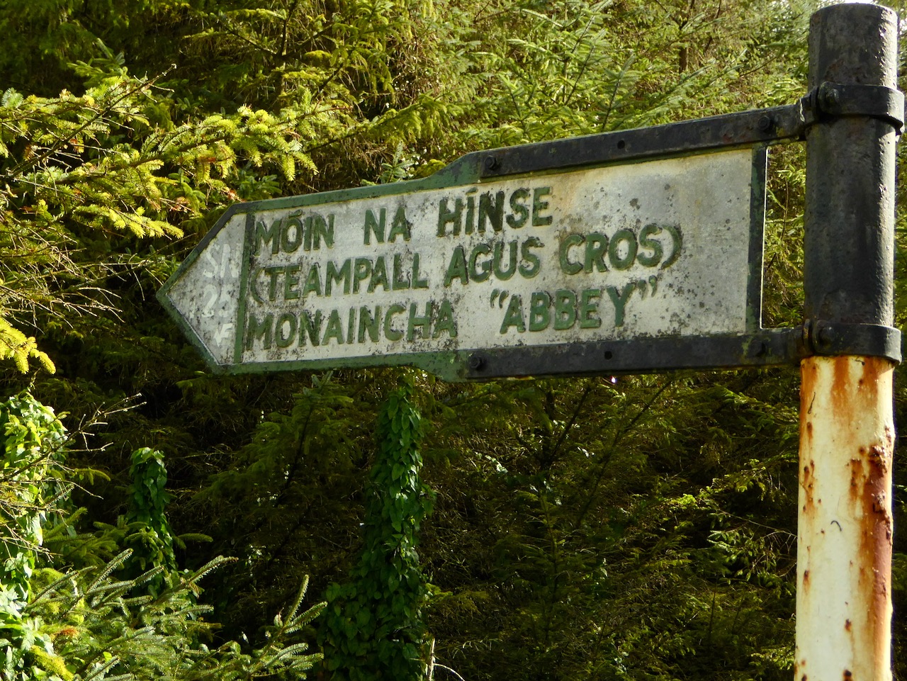
We made this trip because I was studying Irish Romanesque architecture and Monaincha is a fine example, but we had no real idea what to expect and it caught us off guard. An ancient signpost directed us down a rough track through the trees and then by foot across the fields. Our first glimpse was of what looked like an island in the middle of flat land.

We weren’t wrong – this had been an island, called Inchanambeo (Incha na mBeó) which translates as Island of the Living. Curious name, but of course, this being Ireland, there’s a story to it. Here it is from Dúchas, the School’s Folklore Collection, collected by a 12 year old in the 1930s:

On this lake were two islands; the Island of the living which was the smaller of the two was a place to where saints went who wanted to live alone – with God. It was called the Island of the Living because it was said that no one could die who went on this island. Of course this is not to say that their bodies could not die – it meant that their souls could not die, because Our Lord said “He that eateth of this bread shall live for ever”. No woman could go on the large island because she would die. This was often experimented, when men brought female animals on the island but they dropped dead the moment their feet touched the island.

Hmmm – as a woman, perhaps I did indeed go through some kind of portal, since I managed to live through the experience. That explains the Otherworldly feeling!

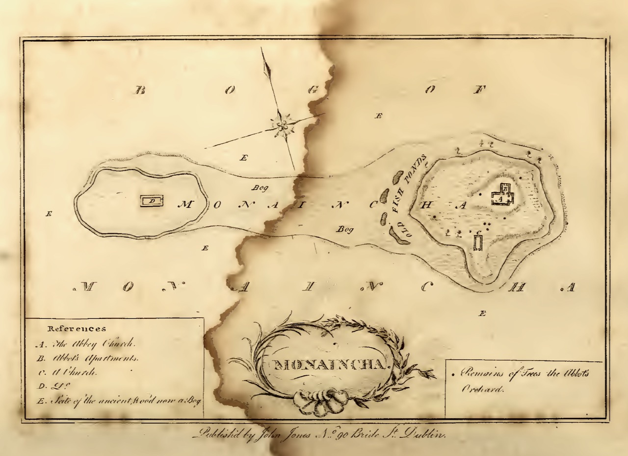
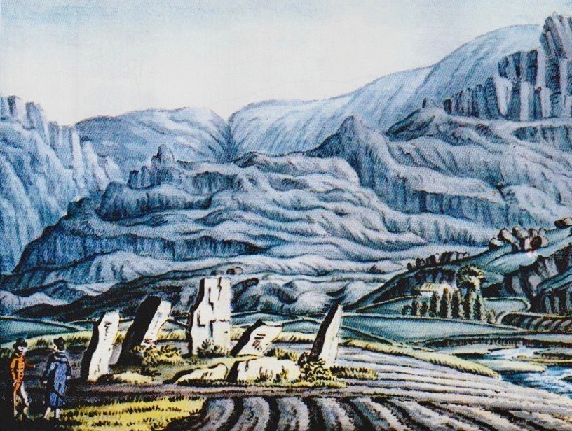
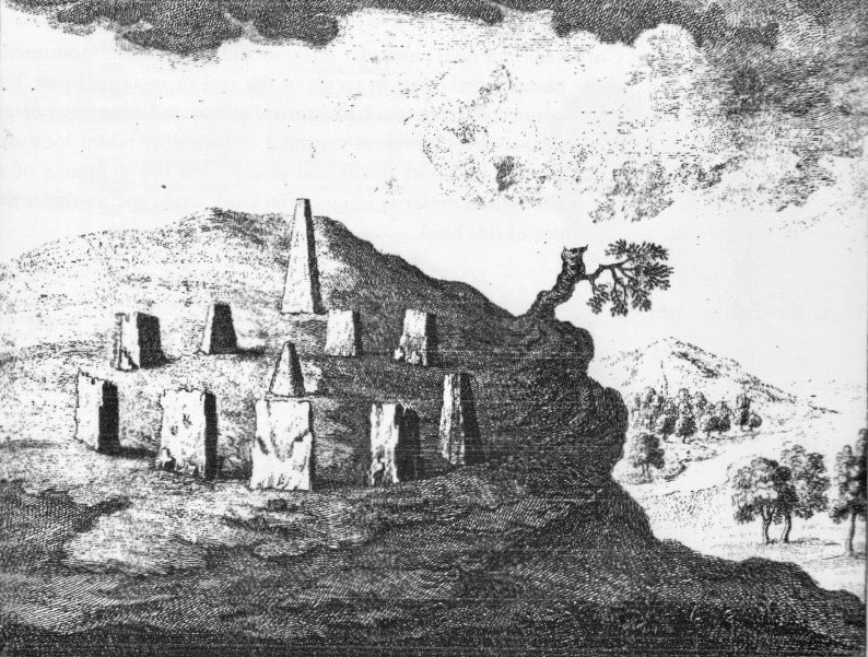
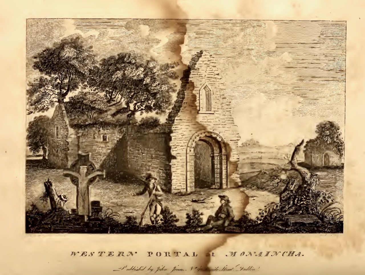
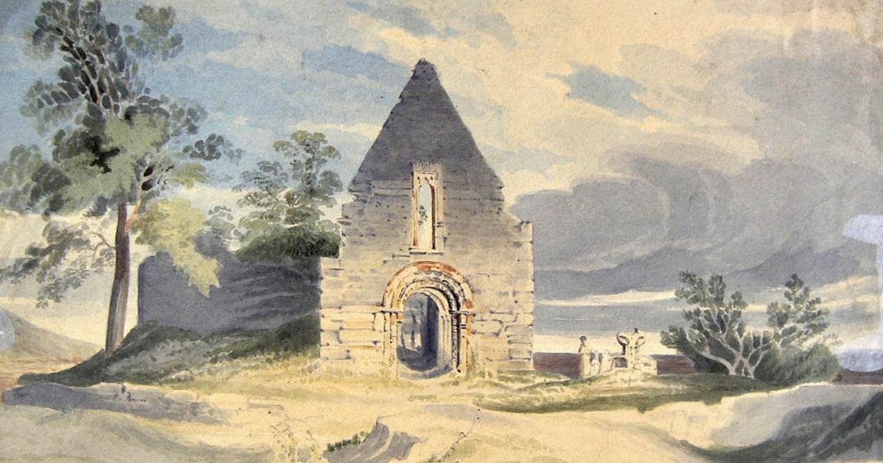
The top image and this one are from Ledwich’s Antiquities of Ireland, published in 1790. His map clearly shows that both islands were still there at that time, with a building still in place on the small island, while the first illustration shows the second building on the large island, no longer there

For this and more Duchas stories about Monaincha, go to this link on the Dúchas website. You will see that Cromwell sacked the monastery, that the woman who gave away the monks’ location was turned to stone along with her cake of bread, that the lake contains hidden treasure, that the water if used improperly would not boil, that many miracles were associated with the saints who lived on Monaincha, and that a white lady roamed the area until banished by a priest but not before she left her mark on him (read the story).

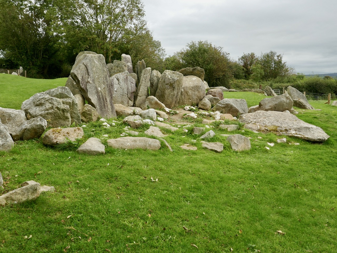
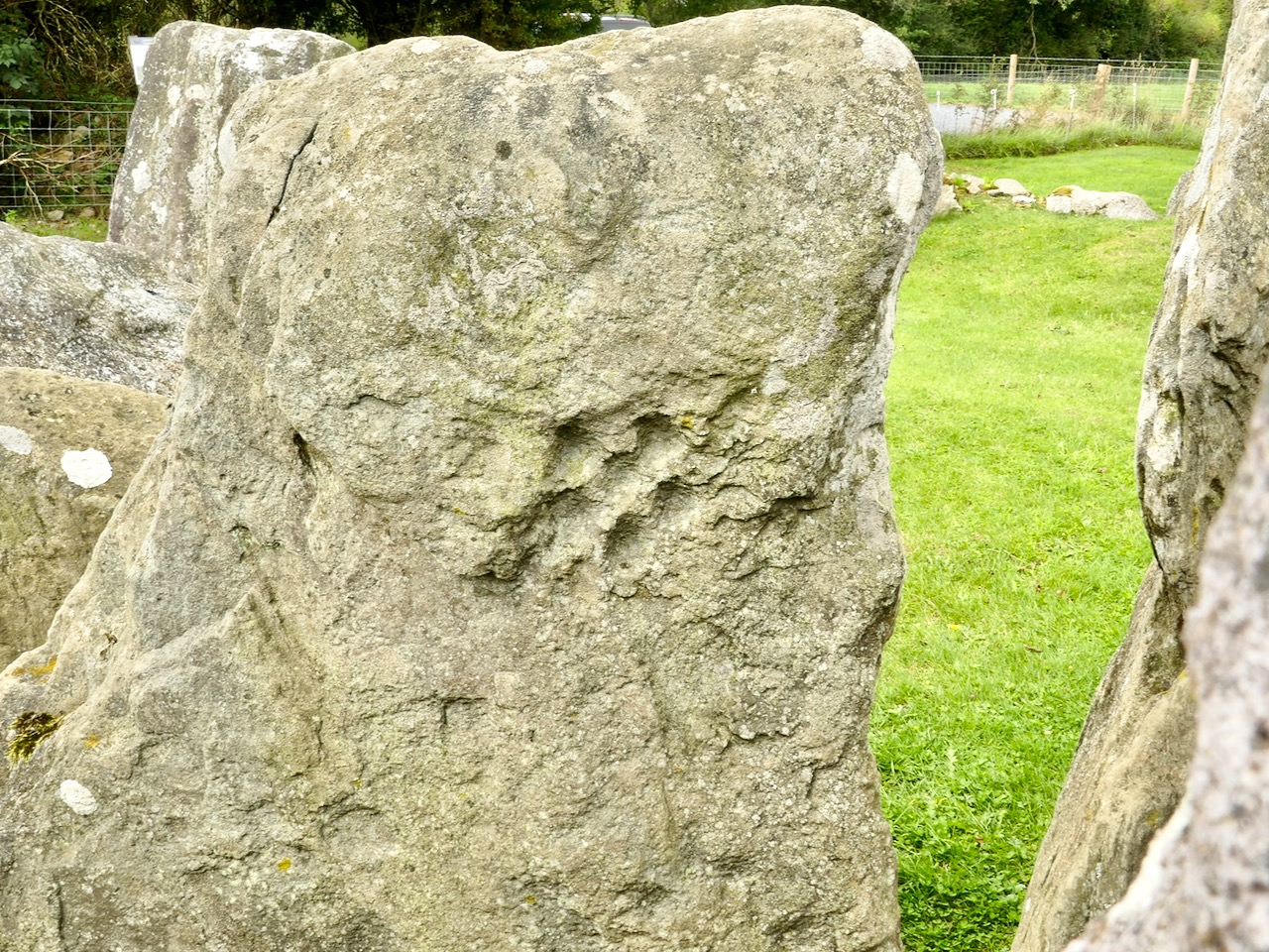
And here it is – the cake of bread that was turned to stone

One of those saints was St Canice, who came on retreat to this sacred spot:

He did not let anyone know where he was but he got letters and messages each day by means of the Garnawn Bawn. This was the White Horse which passed each day without a guide from Agherloe to Monahinche.

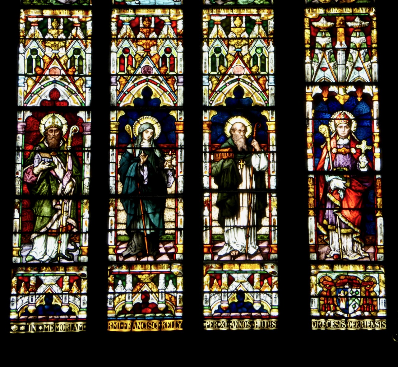
St Canice (second from right) in good company with Sts Patrick, Brigid and Eugene. He’s holding his cathedral. The window is in St Eugene’s church in Derry

But it was St Cronan who built the church:

St Cronan and his monks sought a place where they could build a residence. They proceeded to the parish of Bourney to a place called Bogawn  but looking towards Monahincha they saw the sun shining on it and so fixed the site of their future home on Monahincha. St Cronan lived for a long time in Monahincha and while he was there he prayed a great deal and performed many miracles.

For a more academic history of Monaincha we turn to the bible of all things Romanesque, the Corpus of Romanesque Sculpture. From it we learn that:

Originally known as Inis Loch Cré, the name Mona Incha was only given to the site in the in later centuries. The earliest monastery here was founded by St Cainneach of Aghaboe in the 7thc as a hermitic settlement. Column Mac Fergus died on Inis CrÈ in 788 as did Elarius, anchorite and scribe, in 807. The latter was St Elair, or Hilary who was patron of the monastery in which the Culdees were instituted in around the 10thc. In 902 Flaithbertach, King of Cashel, came here on pilgrimage. An Augustinian community was established at Mona Incha during the mid-12thc.

In 1397 the monastery, containing a prior and eight canons, was taken under the Pope’s protection and released from paying Episcopal dues because of its extreme poverty. At about the same time the Book of Ballymote described Mona Incha as the 31st wonder of the world! In c.1485 the prior and convent finally moved to Holy Cross at Corbally, as the canons found the vapours from the marshes surrounding the island unhealthy. Following the Dissolution the church was used as a penal chapel. 

Much of this is based on the erudition and scholarship of Harold Leask, whose three volume book Irish Churches and Monastic Buildings has a section on Monaincha. He also authored, along with C MacNeil, an article in the Journal of the Royal Society of Antiquaries of Ireland which is a very comprehensive account of all that can be gleaned from annals and hagiographies of the history of Monaincha*.

Leask’s plan of the ruins at Monaincha

He cites Gerald Barry’s (better known as Giraldus Cambrensis) Topographia Hibernia (written in 1188), to show how ancient is the tradition of the Isle of the Living.

There is, he says, a lake in North Munster containing two islands, a greater and a less. The greater has a church of an ancient religious order and the less has a chapel served by a few celibates whom they call Celicolae or Colidei [Culdees – an ancient hermetic order]. No woman or animal of the female sex could enter the greater island without dying immediately. This has been put to the proof many times by means of dogs, cats, and other animals of that sex, which have often been brought to it as a test, and have died at once. As regards the birds of the district, it is wonderful how, when the males settle at random on the bushes of the islands the hen birds fly past and leave the males there and avoid that island like a plague, as if well aware of its natural power.  No one ever died or could die in the smaller island, whence it is called the Isle of the Living; yet from time to time persons are afflicted with deadly ailments and suffer agonies to their last breath. When they feel there is no longer any hope of really living, and by the increase of their disease they are in the end so distressed that they would rather dies outright than continue in living death, they have themselves brought at last in a boat to the greater island, and they give up the ghost as soon as they touch the land.

Leask and MacNeill go on to state that the place had been the site of pilgrimage formerly and some stations were still visible in 1848, and that the proprietor of the place had drained the lake in the 1820s or so and forbade all access to the church either for burial or pilgrimage, destroyed tombstones and erected round the church a circular mound, composed, the people say, of the mortal remains of the hundred generations deposited in that favourite churchyard.

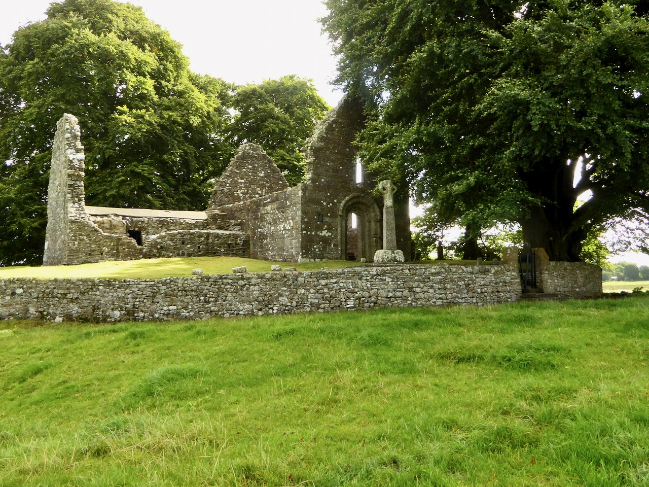
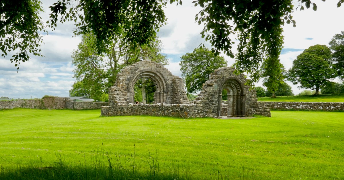
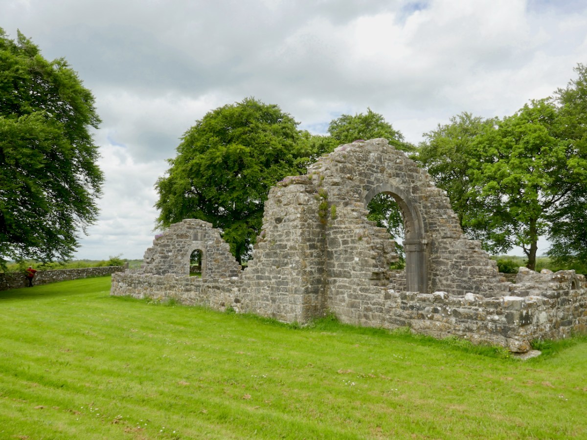
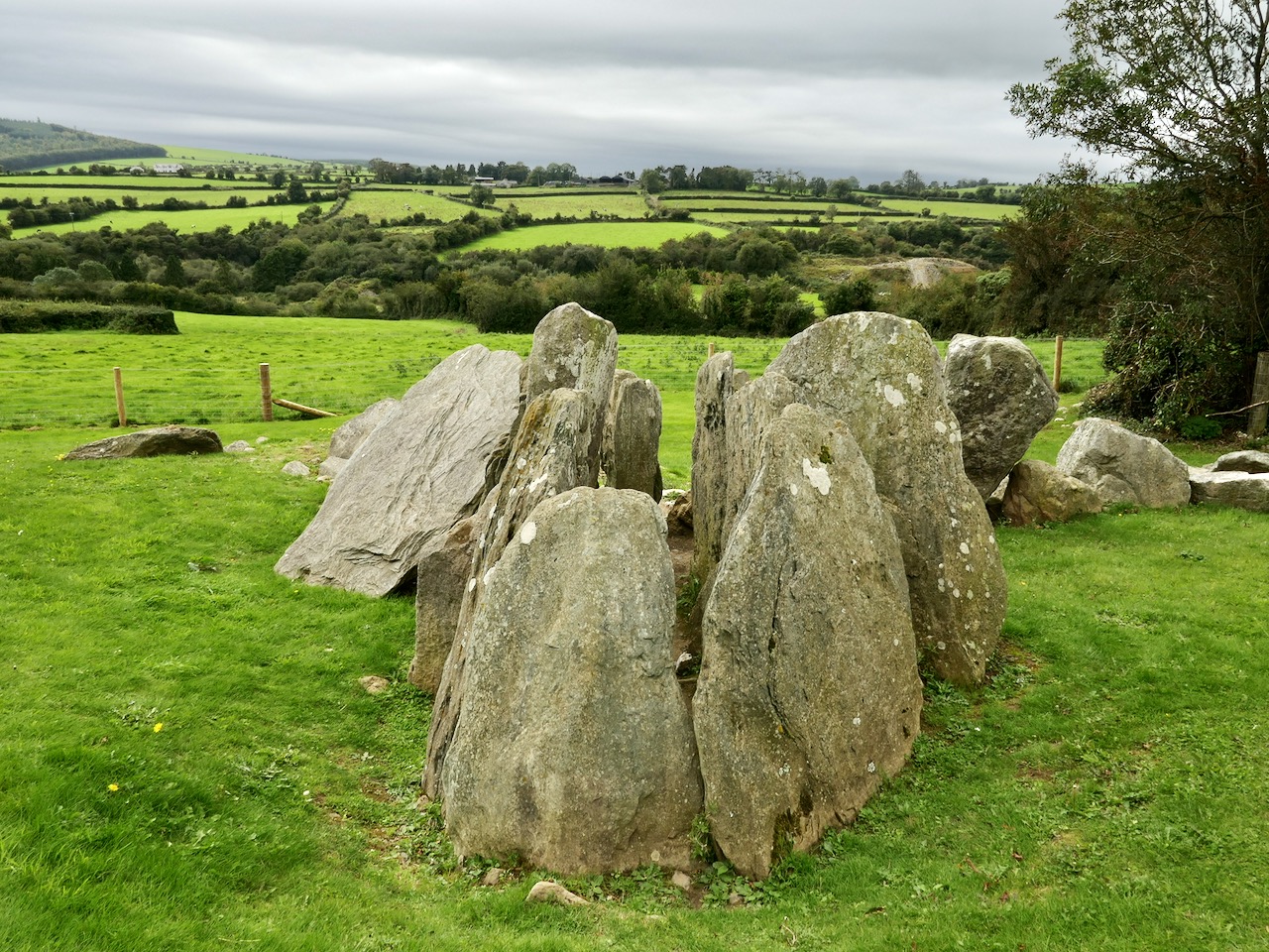
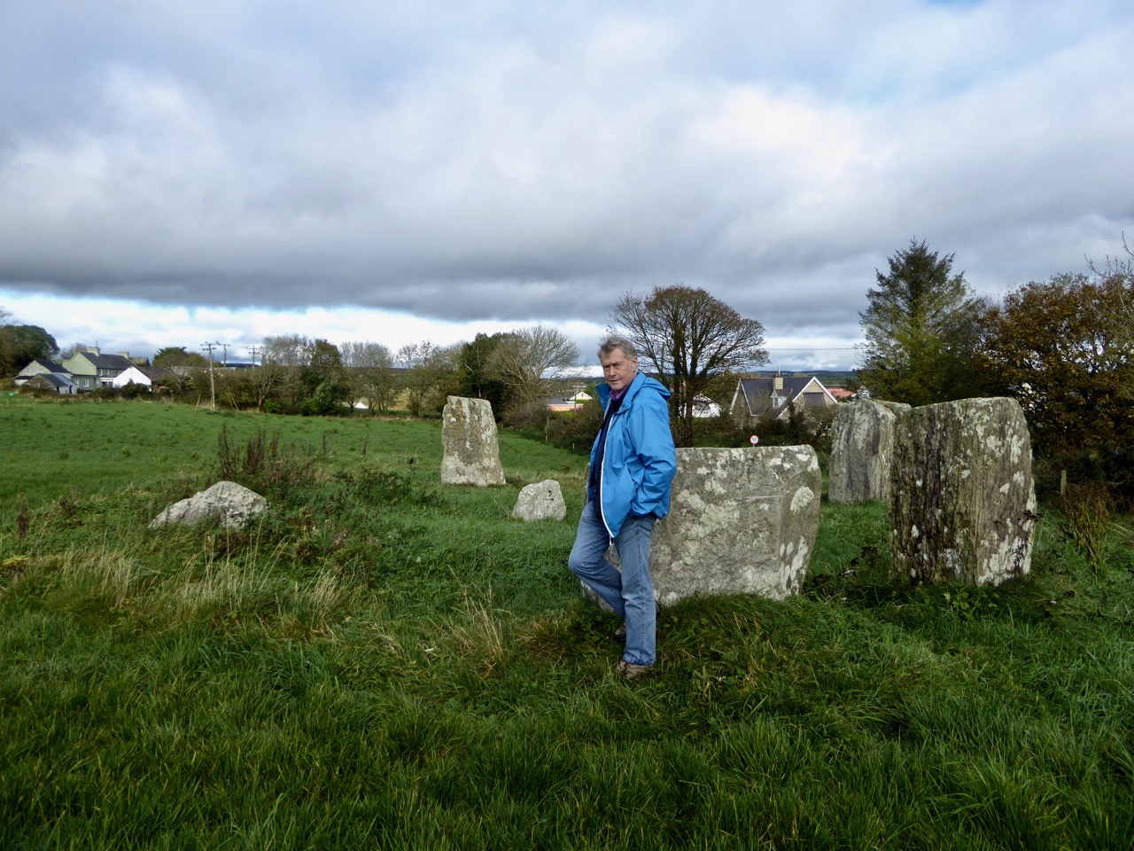
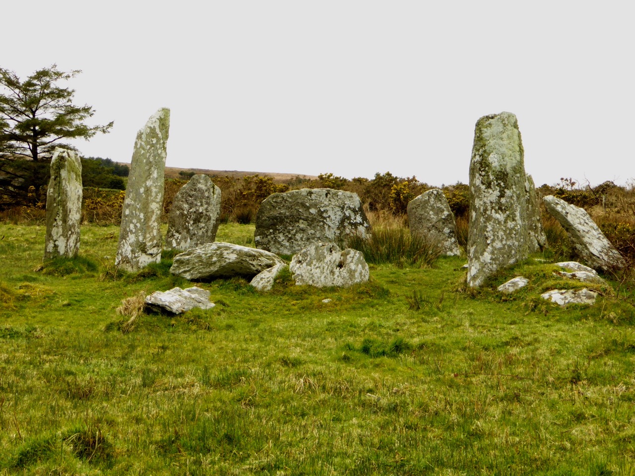
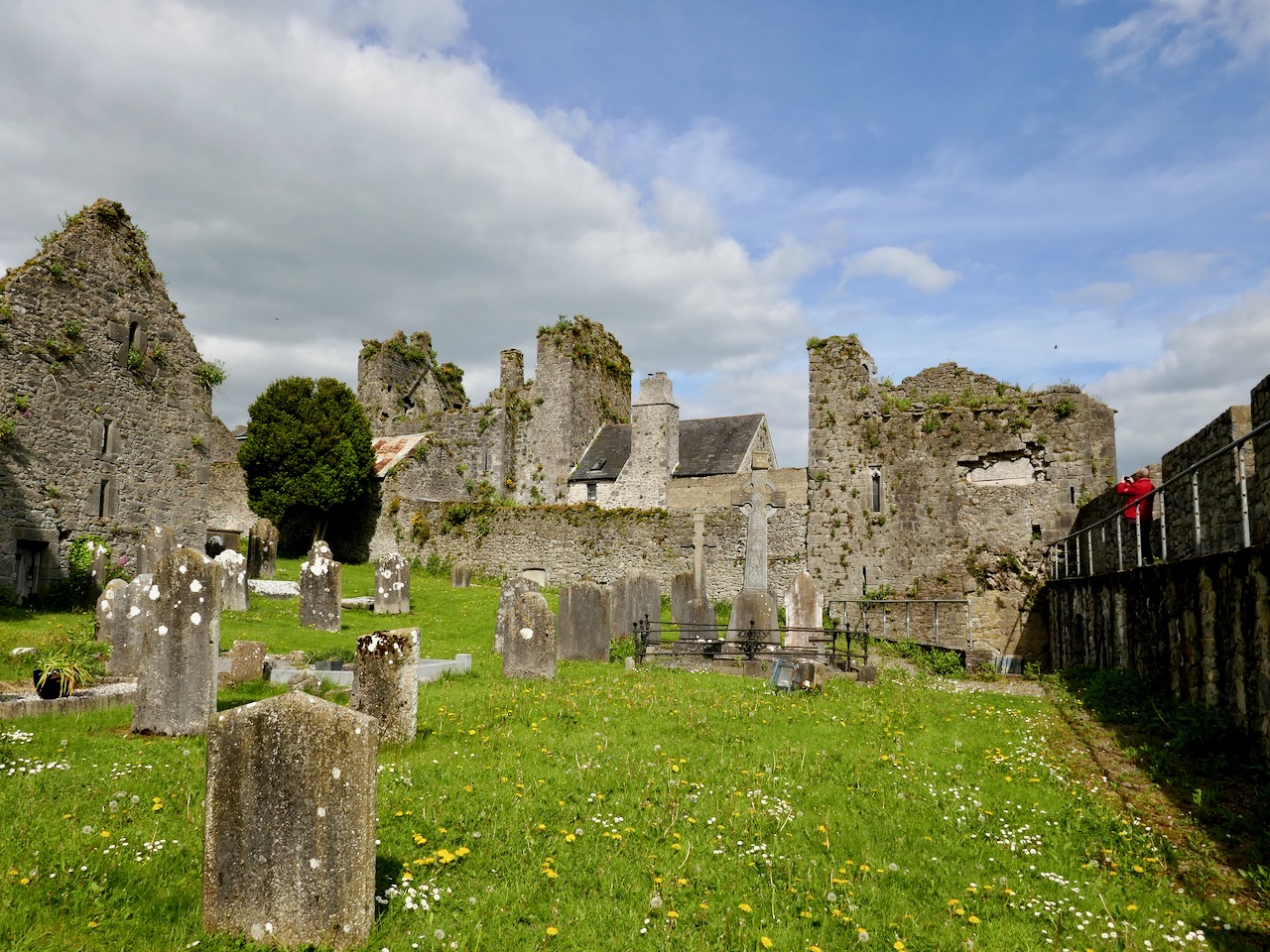
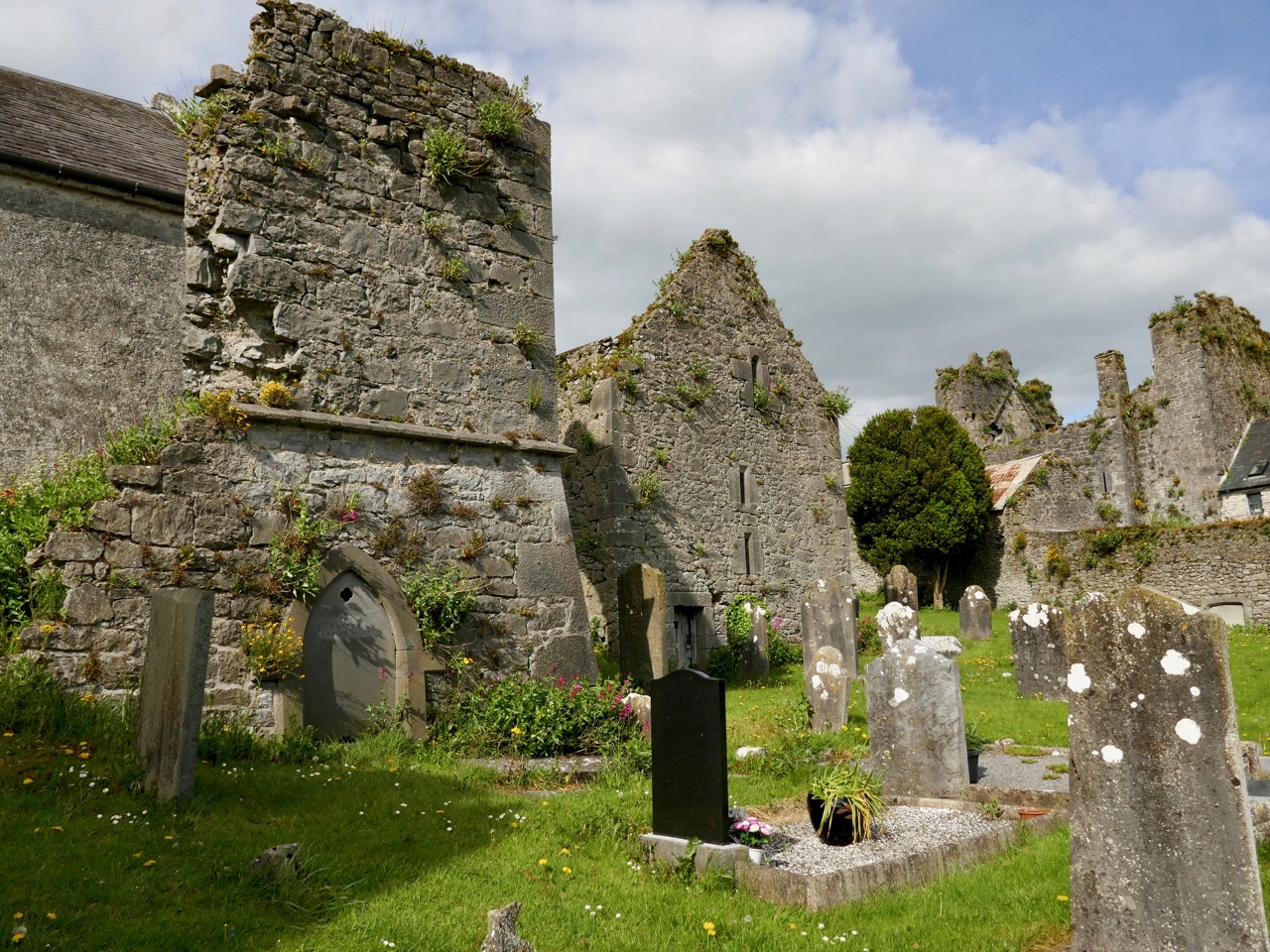
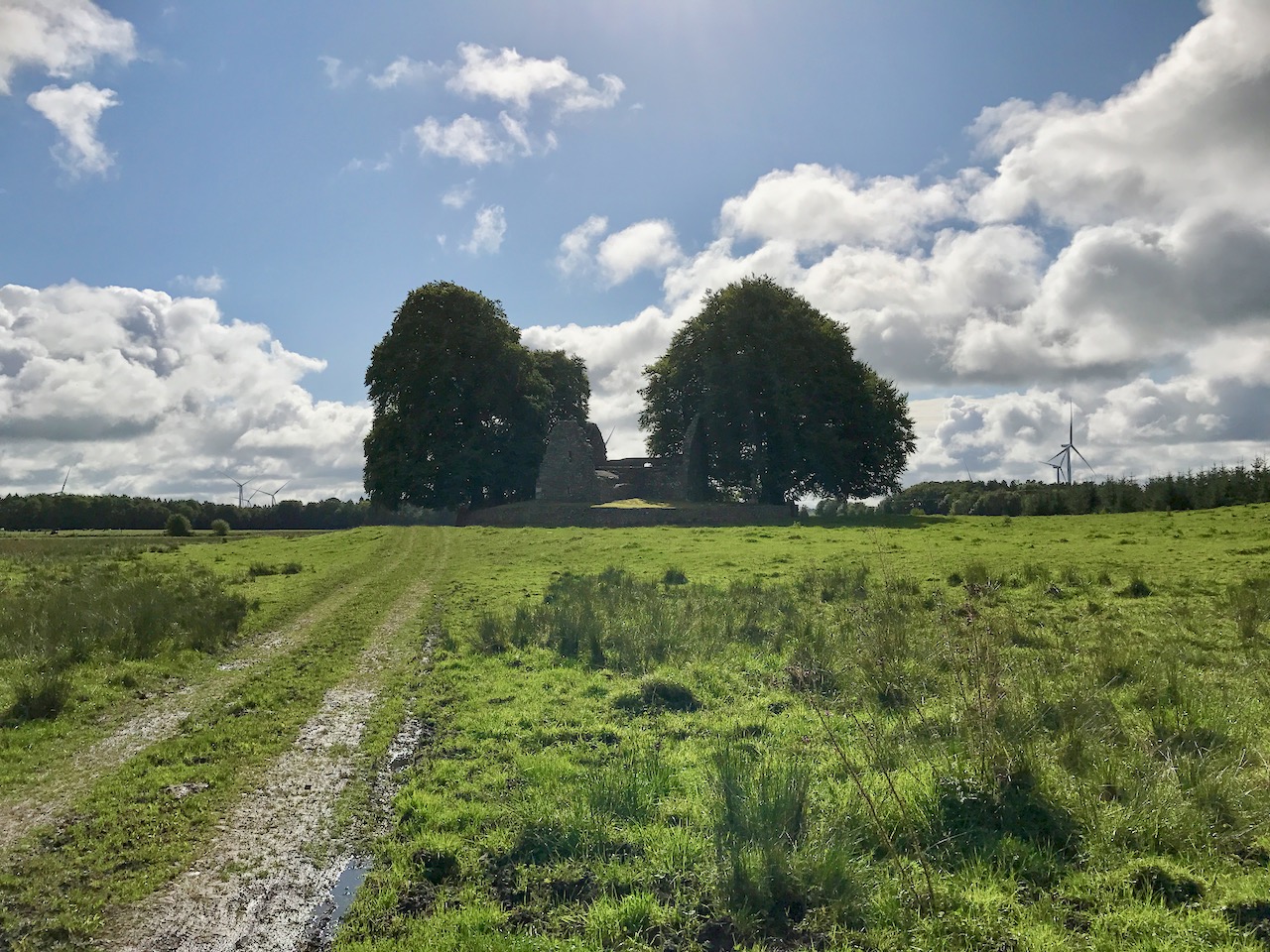
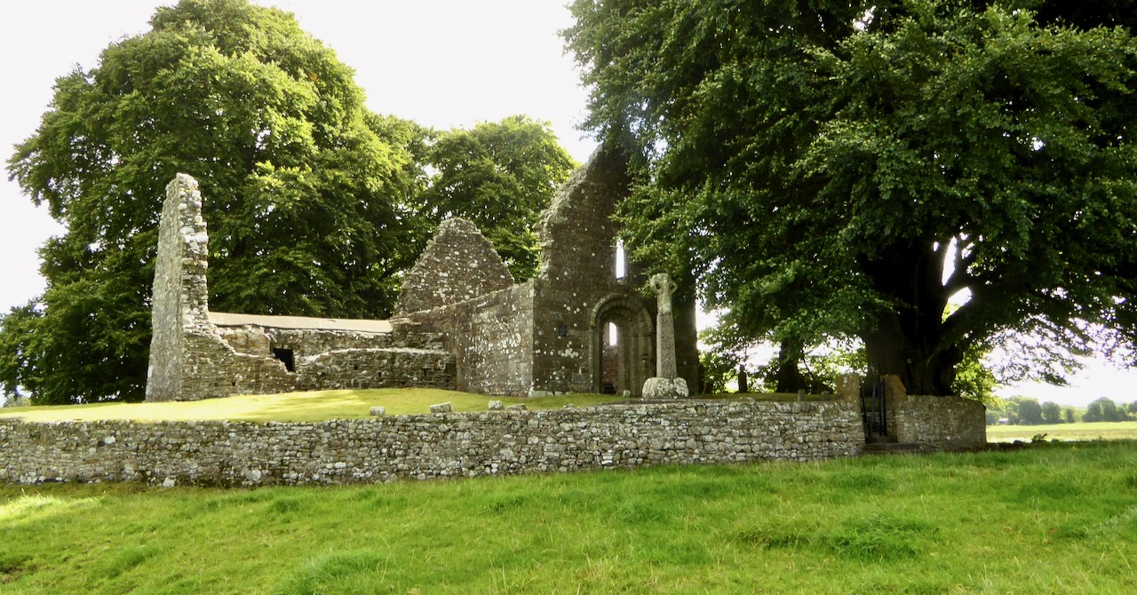
What was once the larger island (there is no sign now of a second one) is still, as Leask described in the 1920s, a circular raised platform, due to the draining of the surrounding land, but there is still very much a sense of travelling across an open expanse to get to it. Marooned in the middle of a large field, the island is visible as a group of very tall trees and it’s not until you get close to it that you begin to see the structures.

As with many such sites in Ireland, the graveyard surrounding the ruined church, despite what Leask asserts, appears to be still intact. This adds to the reverential feeling of the place, as do the enormous trees, which must be hundreds of years old. A partly reconstructed high cross stands at the entrance – Robert wrote about this one in his post Fading Treasures.

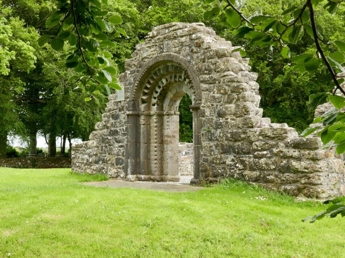
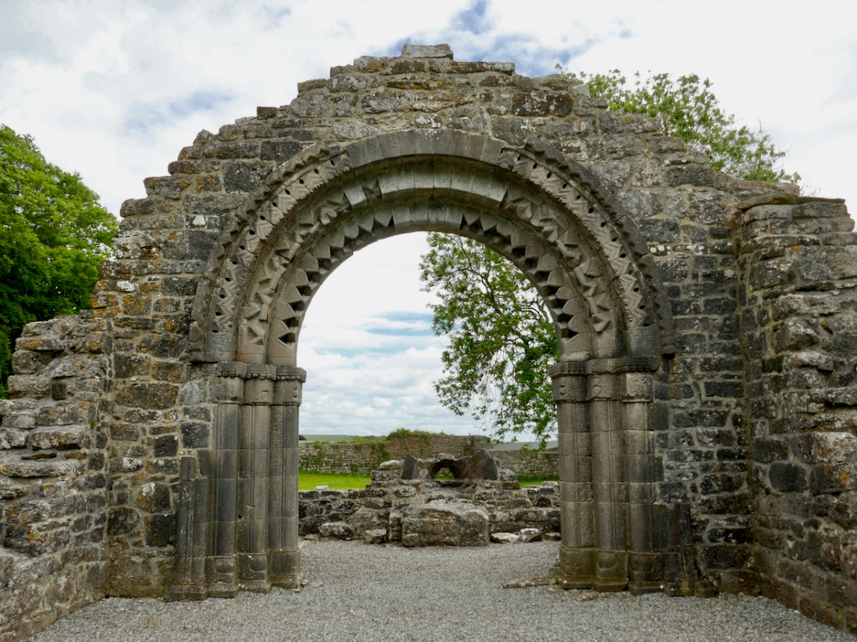
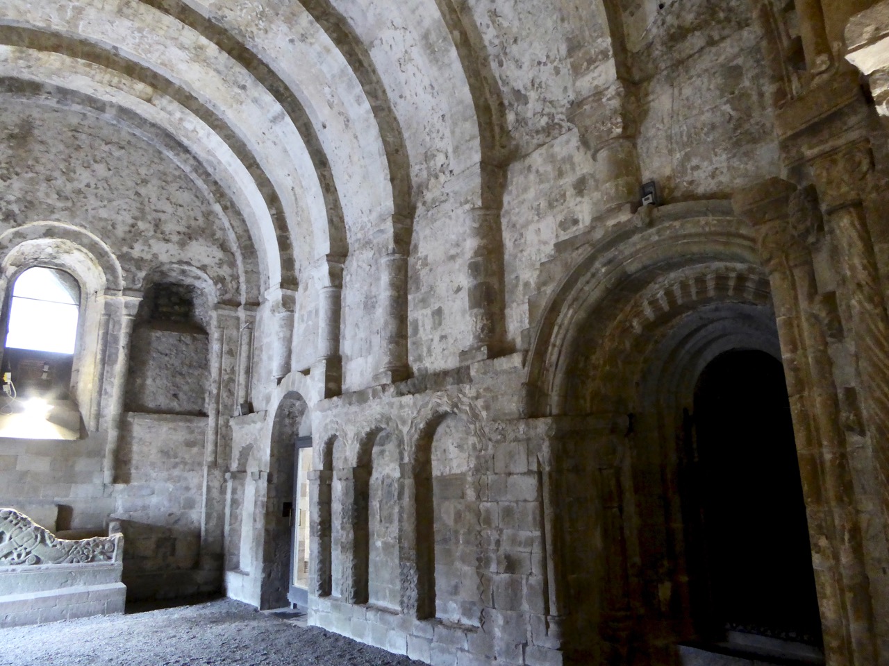
The church is a Romanesque gem. (For more about Irish Romanesque architecture, I have provided a list of previous posts at the bottom of this post.) Dating to the twelfth century, it is a nave and chancel church, fairly typical of the time. There is a later addition on the north side, referred to as a sacristy in Leask’s plan. The sacristy is shown in the Ledwich drawing (first image at top of post), which dates from the 1790s.  As could be seen also in Ledwich’s site map, there was much more to the whole site than there is now.

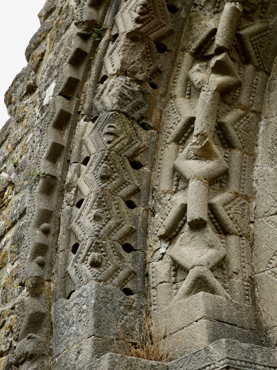
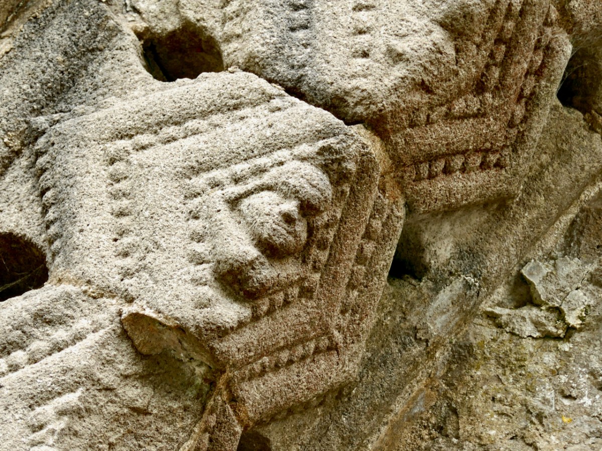
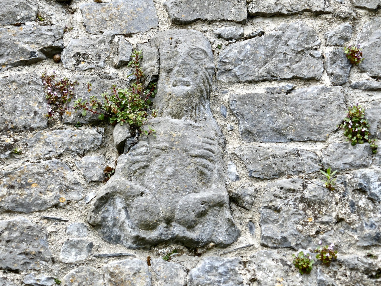
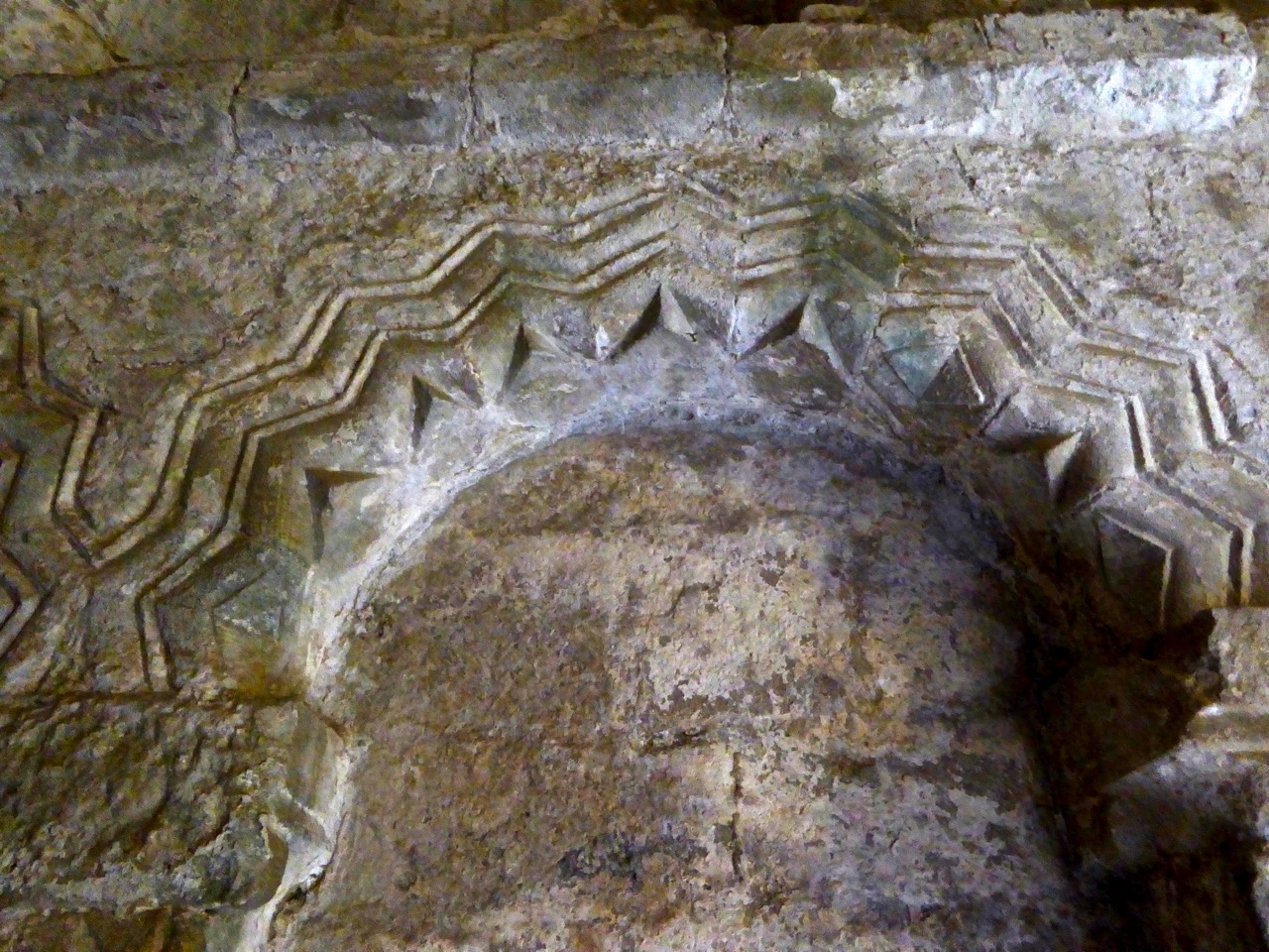
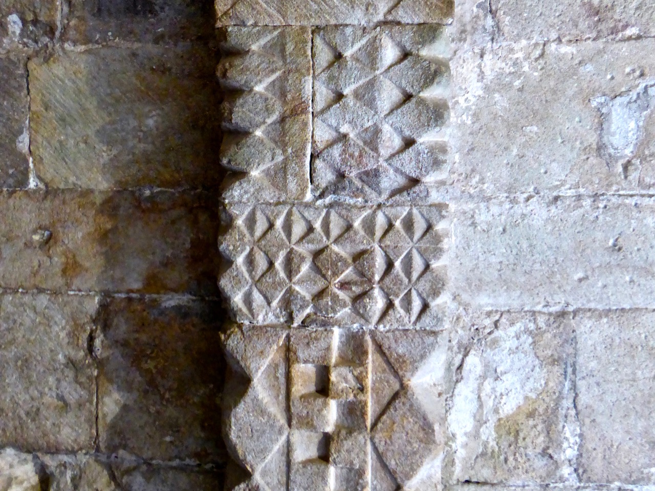
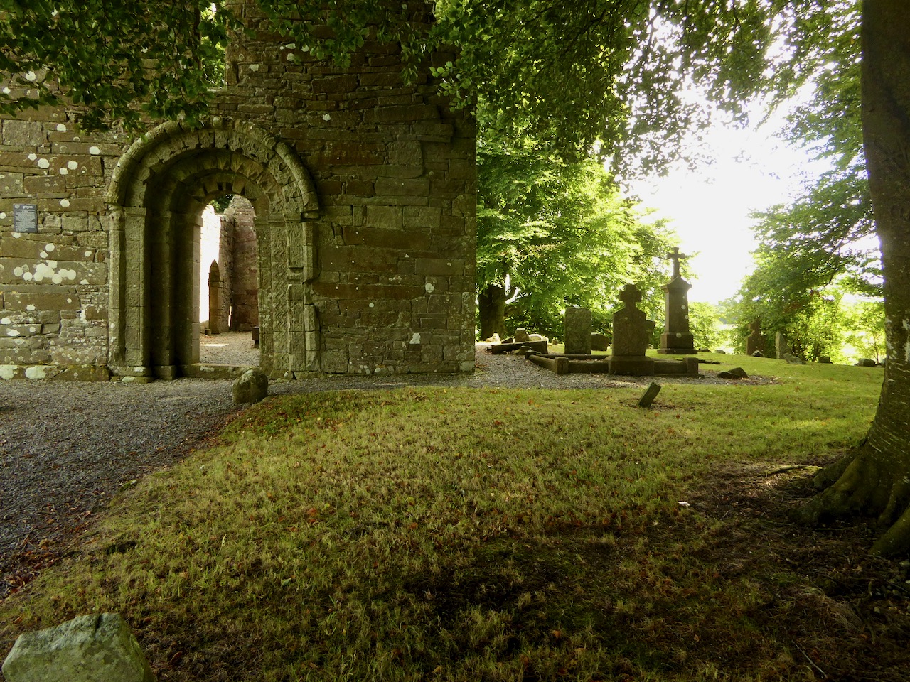
The main door has three (or four, depending on who’s counting) orders, each one carved in the Romanesque fashion with chevrons, zigzags, pellets, floral motifs within lozenges, and some scrollwork. Although weathered, most of the the carvings are still clear to see and very attractive. There are hints of animal heads but they are difficult to discern.

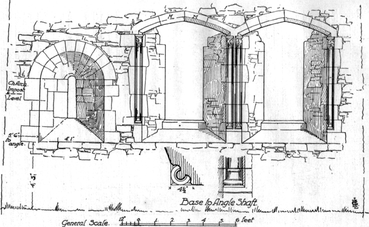
One of the pleasure of Leask’s accounts is his wonderful line drawings. In his plan of the door M stands for ‘modern’ – the doorway was repaired, probably by the Office of Public Works, at some time before his visit

The door is much plainer on the inside, with only one order and no visible carvings. This is normal in Romanesque buildings – the difference between the elaborate entrance and the unadorned exit is often quite startling.

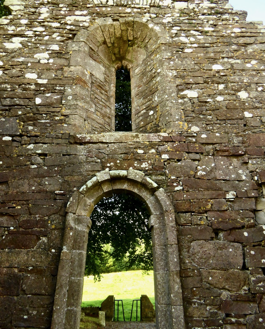
Above the door is a narrow window that was modified in the 15th century by adding an ogee head to the top of the frame

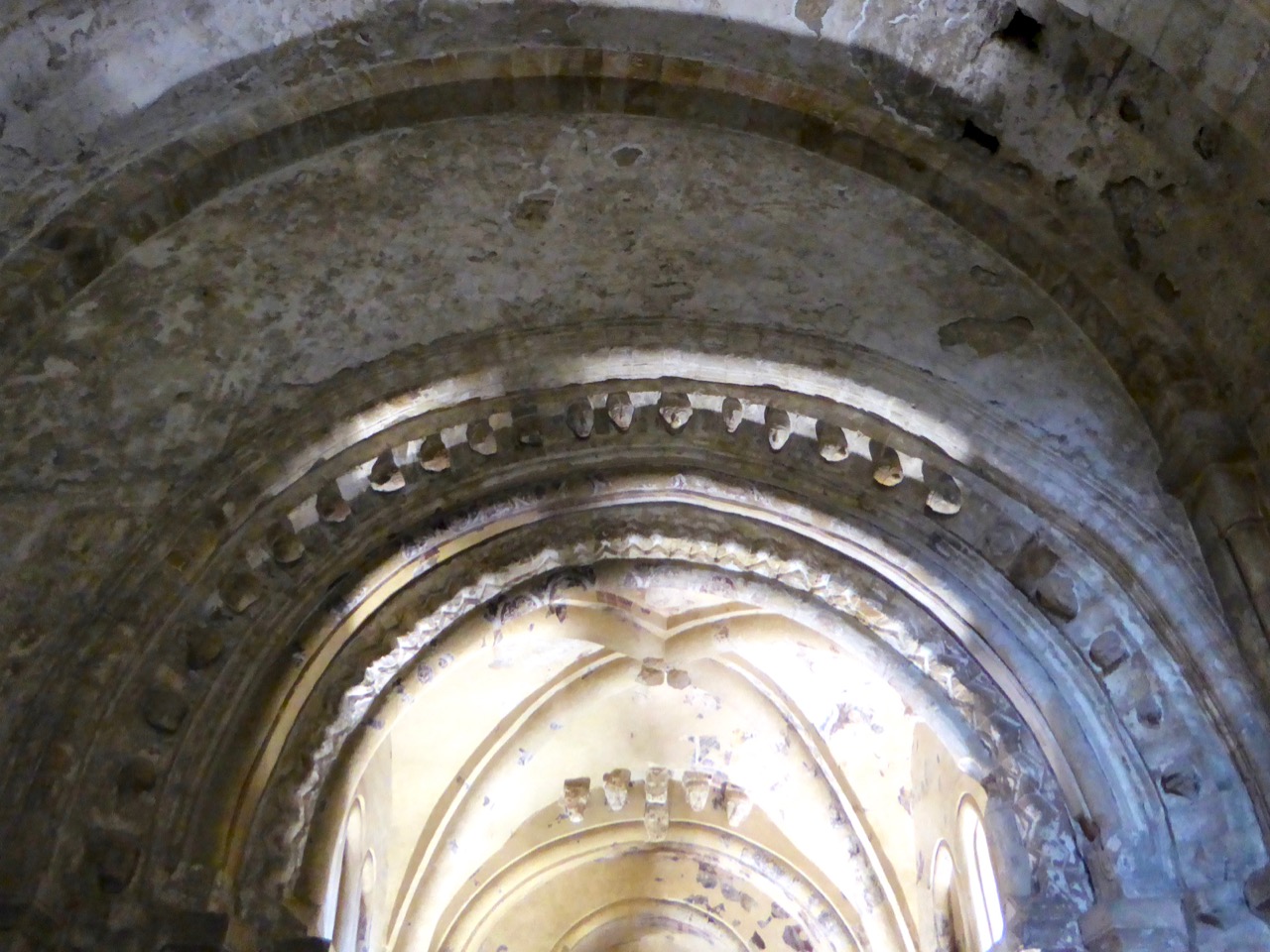
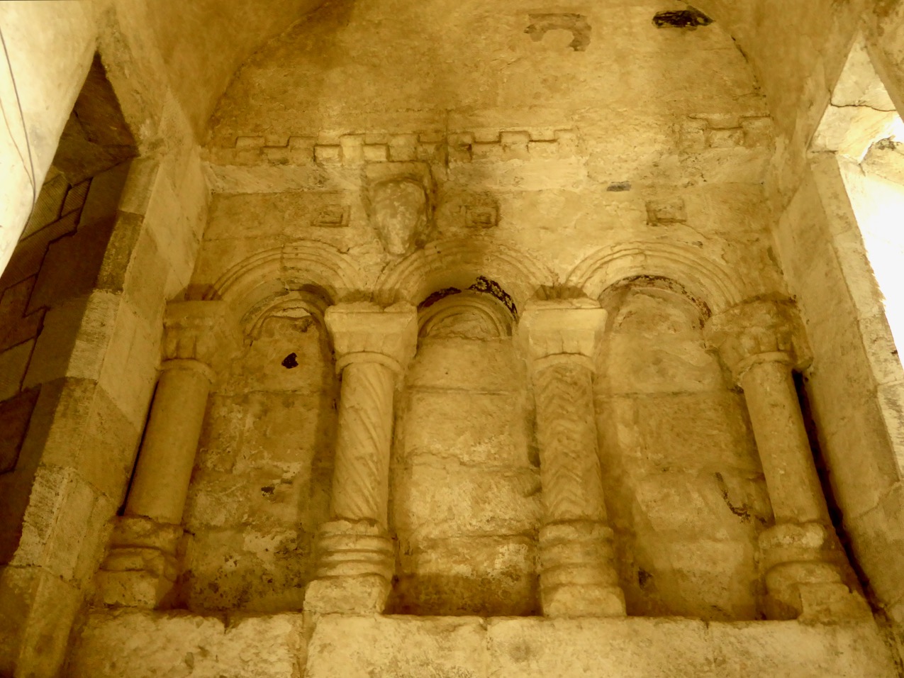
Inside, the nave has some fine windows, although not all of them bear scrutiny as original to the 12th century period of construction.

Only the smallest window is recognisably Romanesque

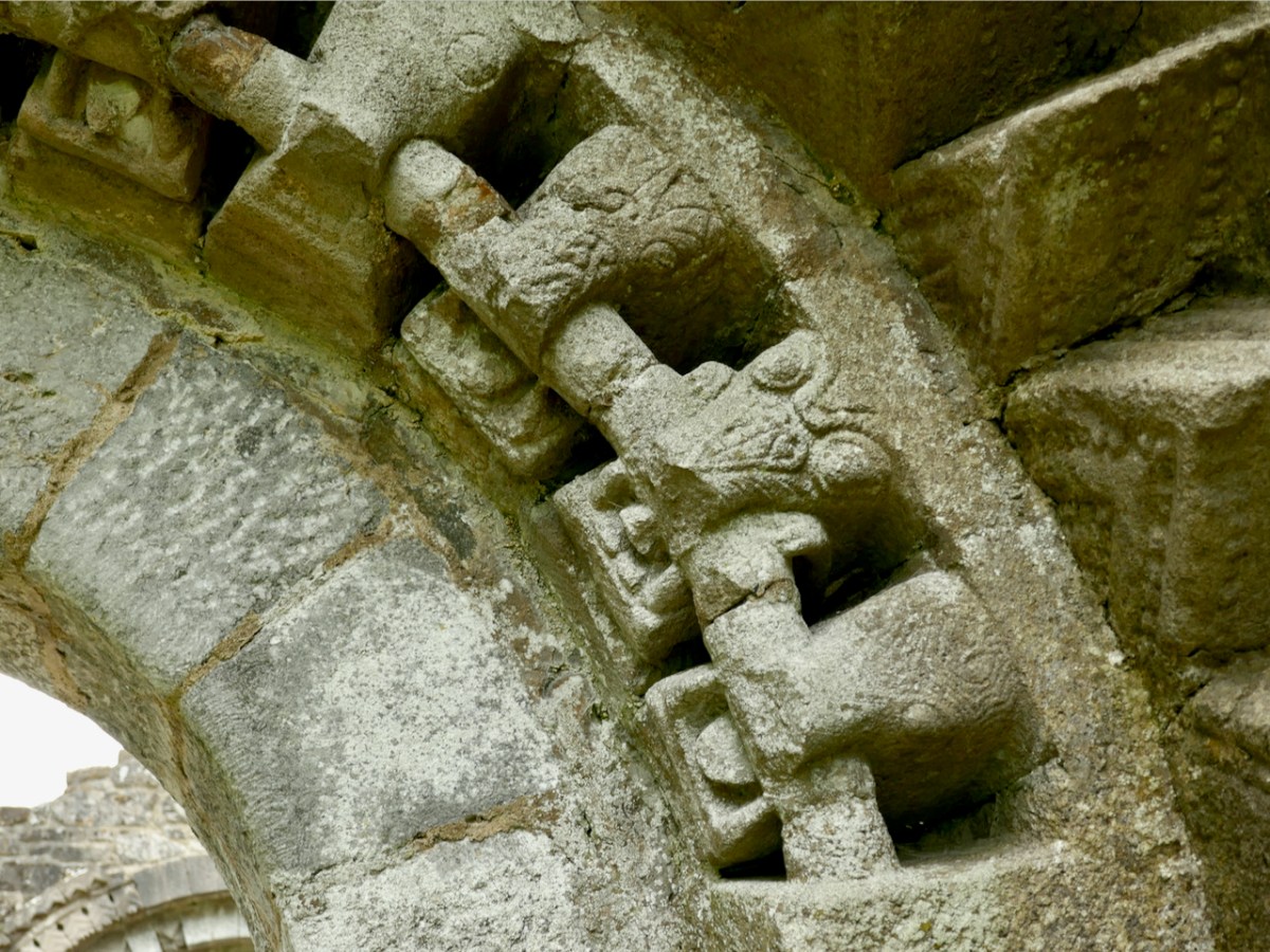
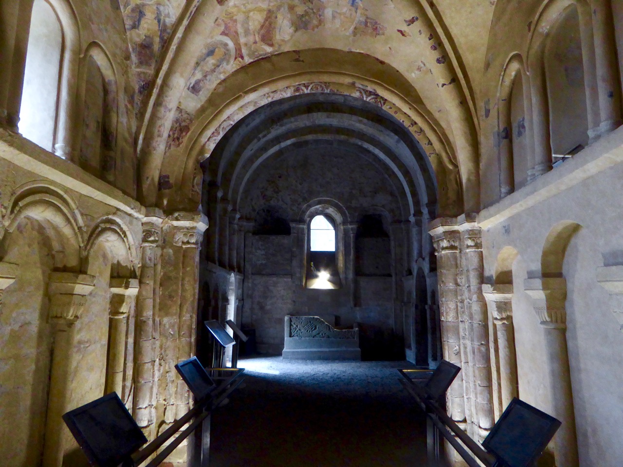
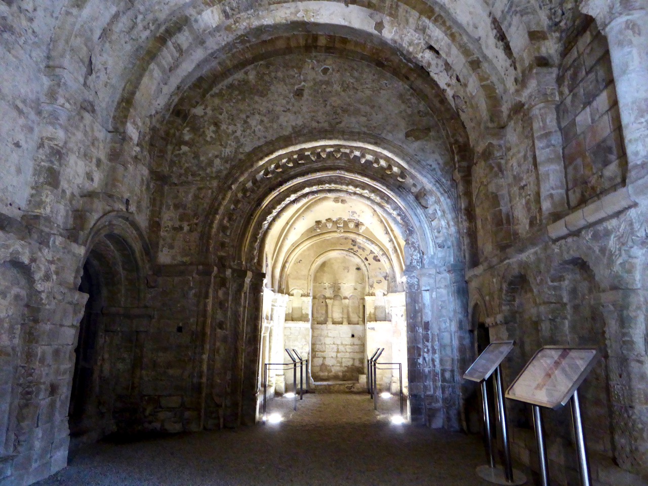
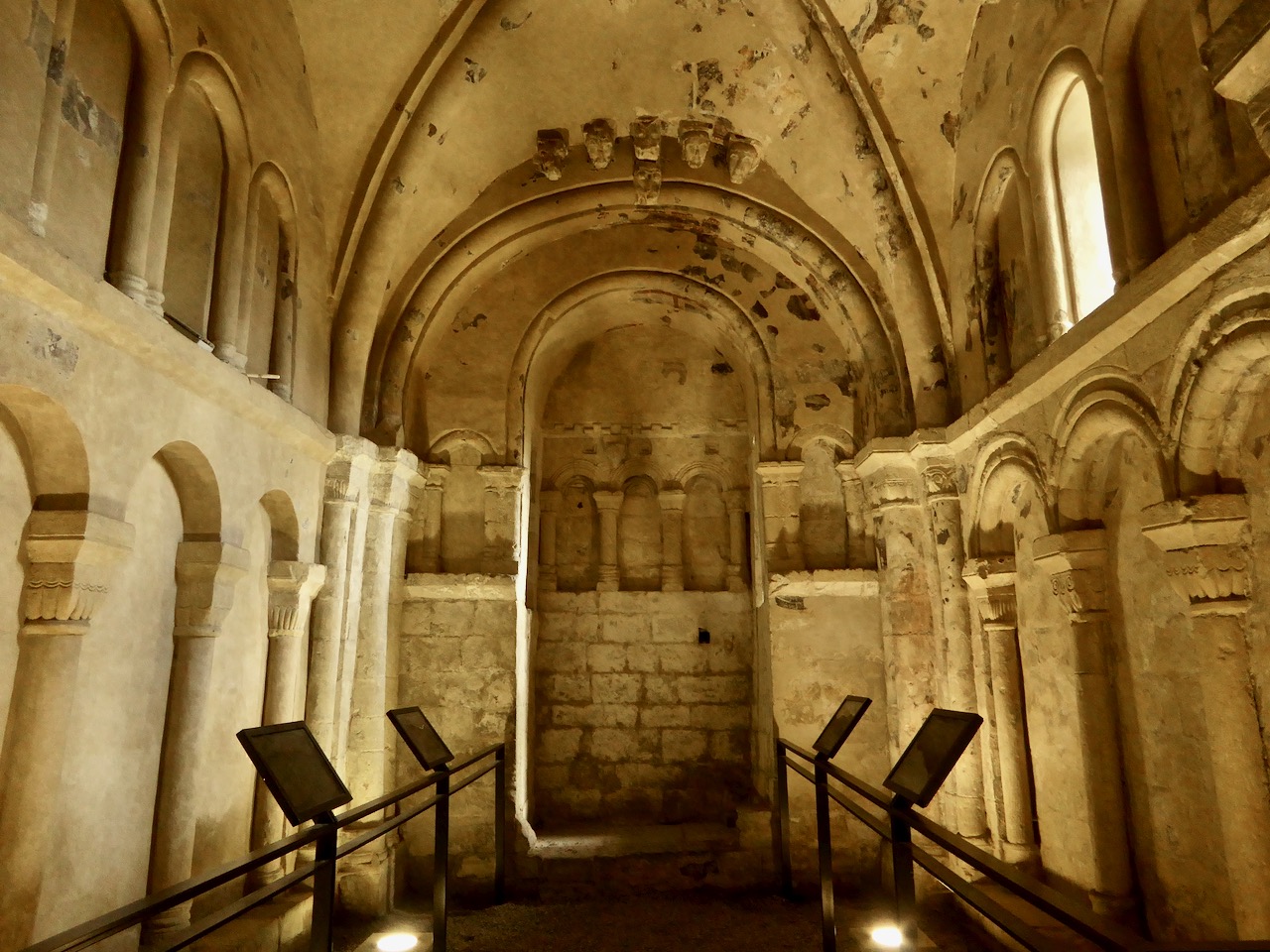
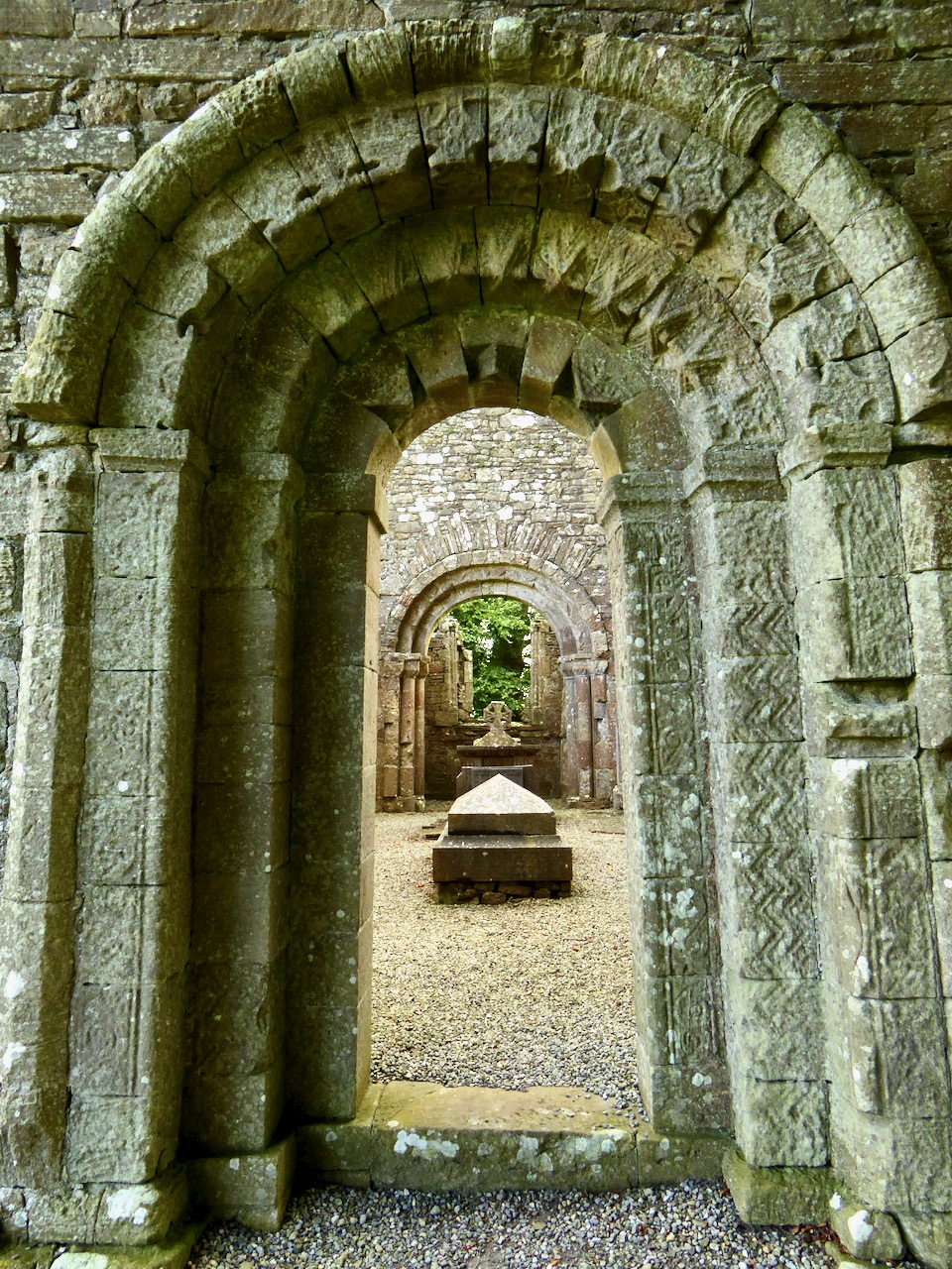
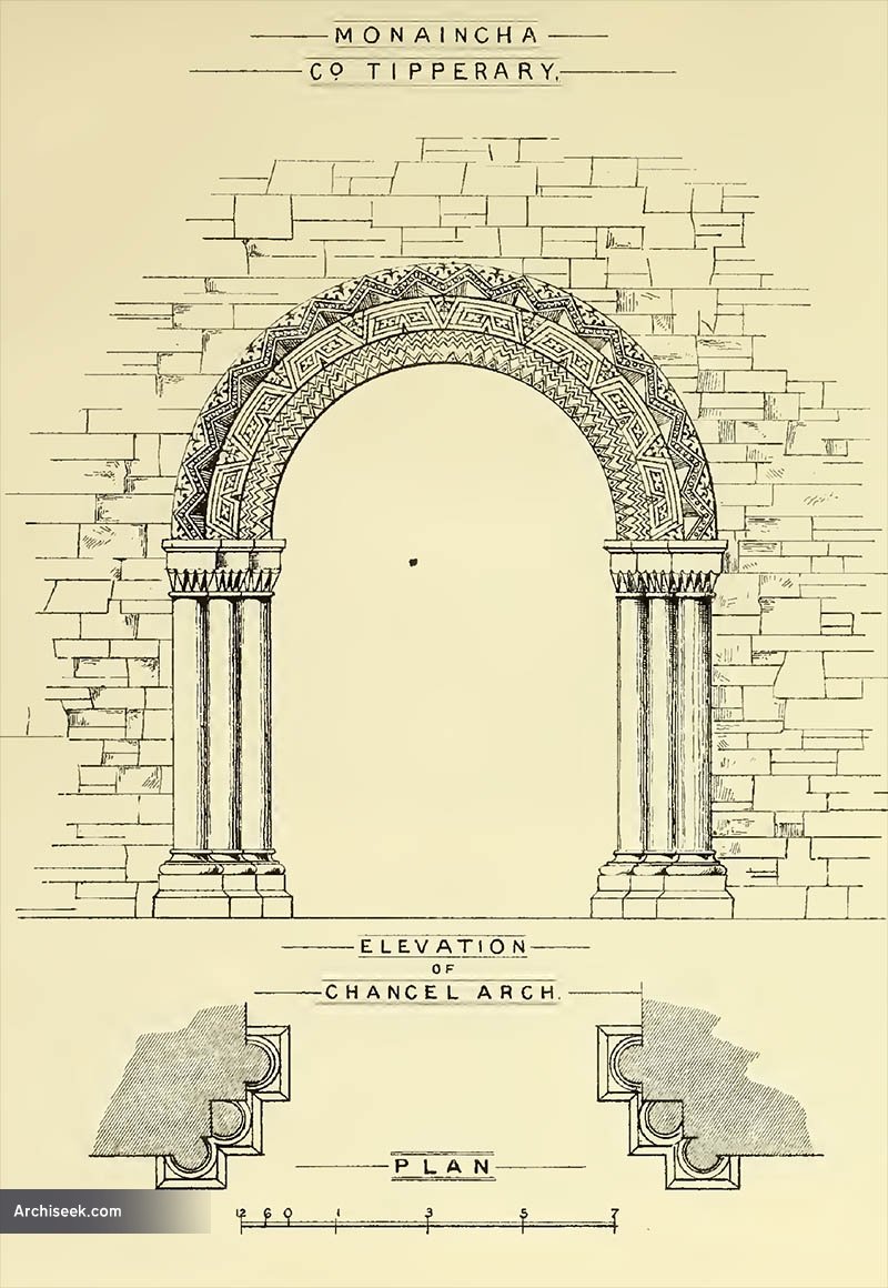
But it is the chancel arch that dominates the space. It separates the small chancel – the area where the altar would have been and mass would have been celebrated – from the nave where the monks and the faithful would have gathered.

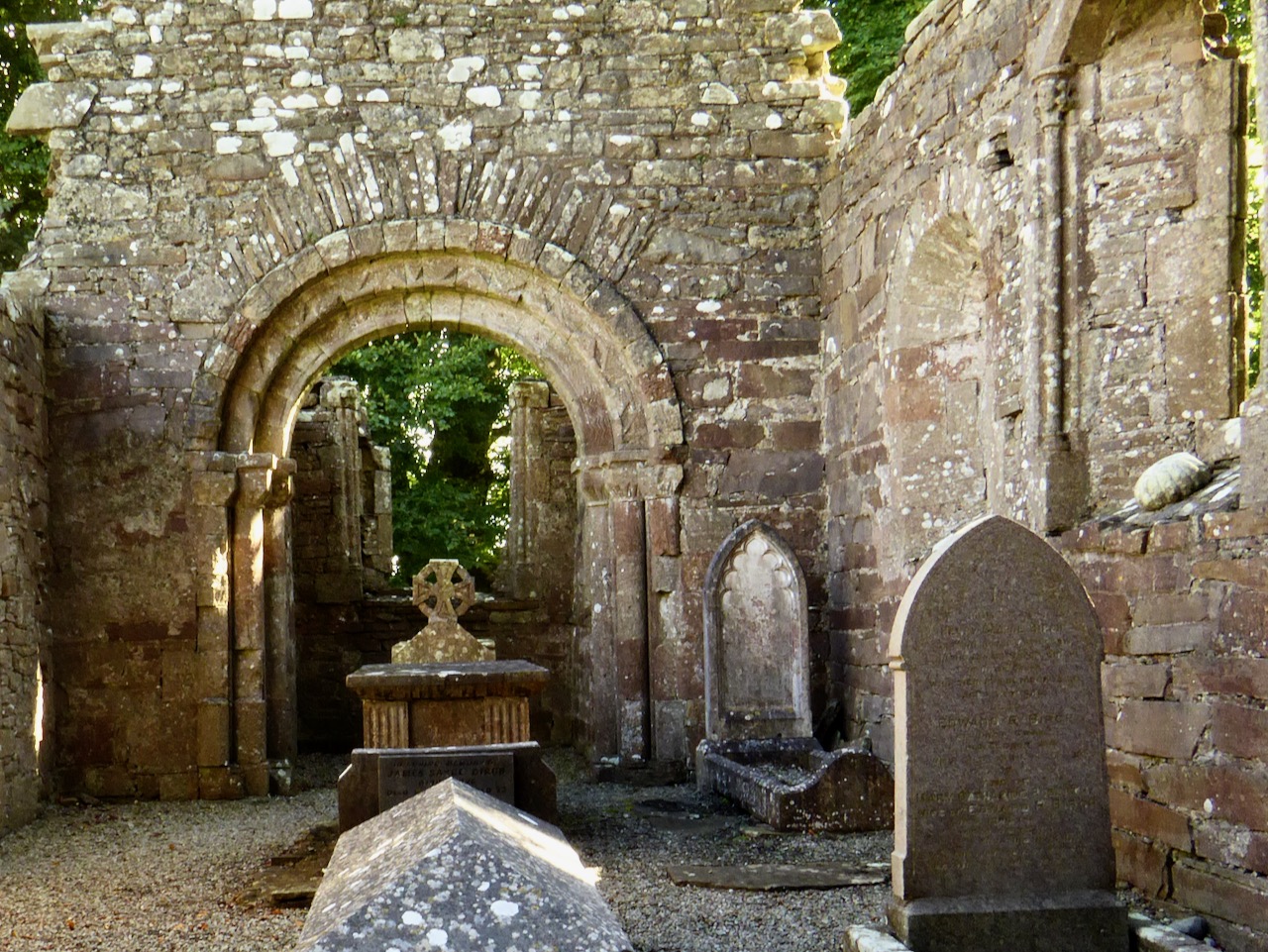
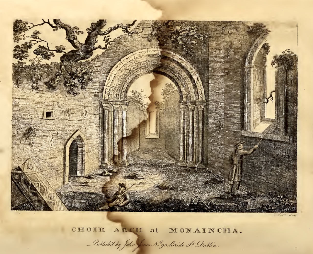
Photograph taken in 2017 and drawing done in 1790. In Ledwich’s drawing the entry to the vaulted sacristy (probably 15th century) is on the left

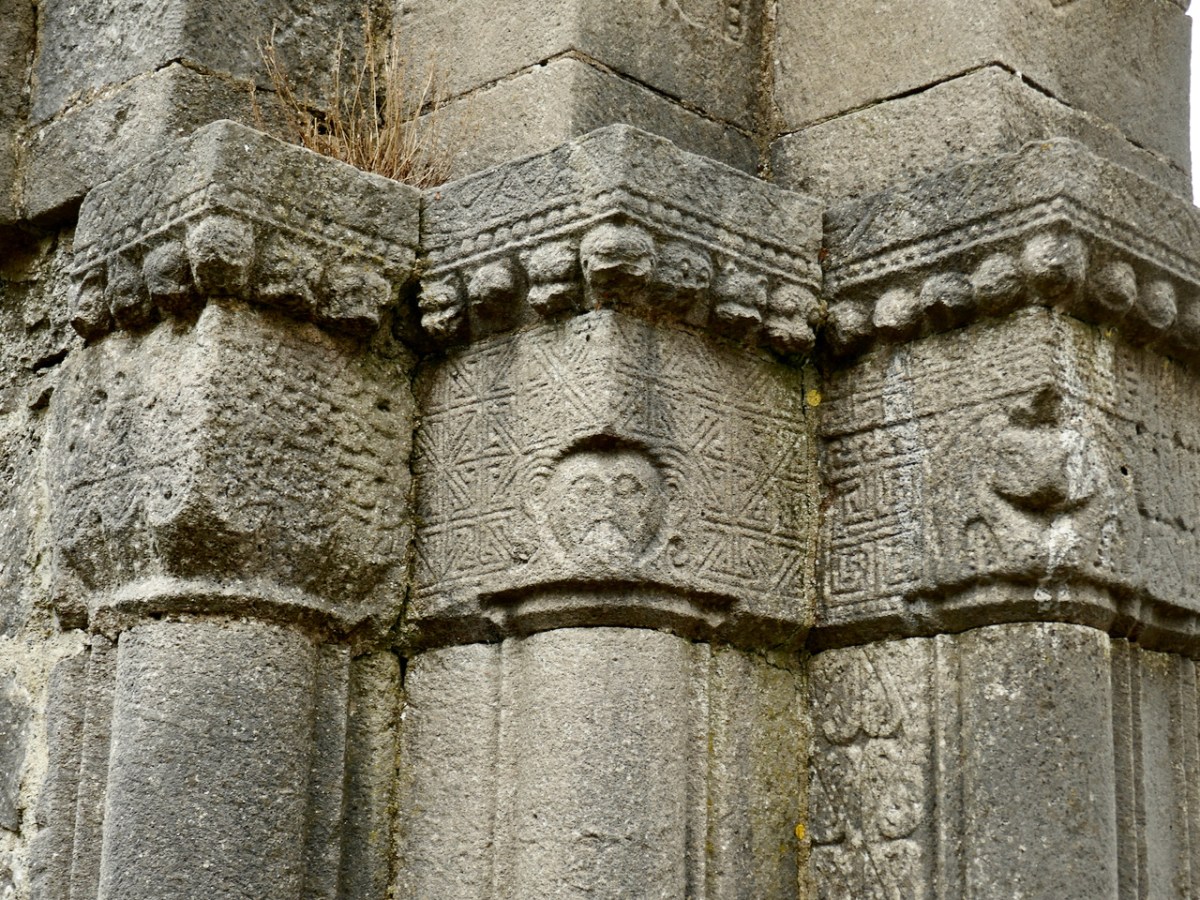
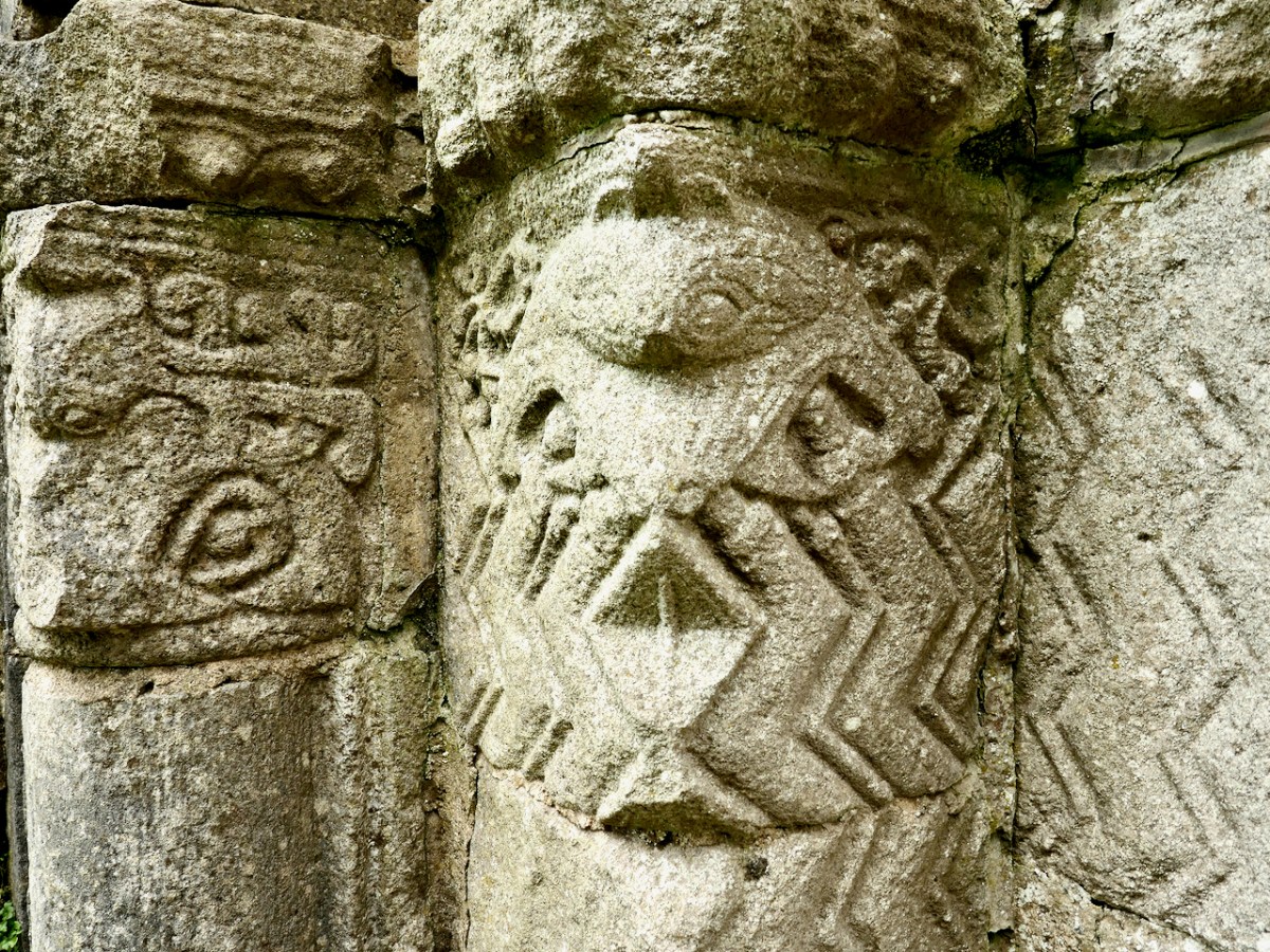
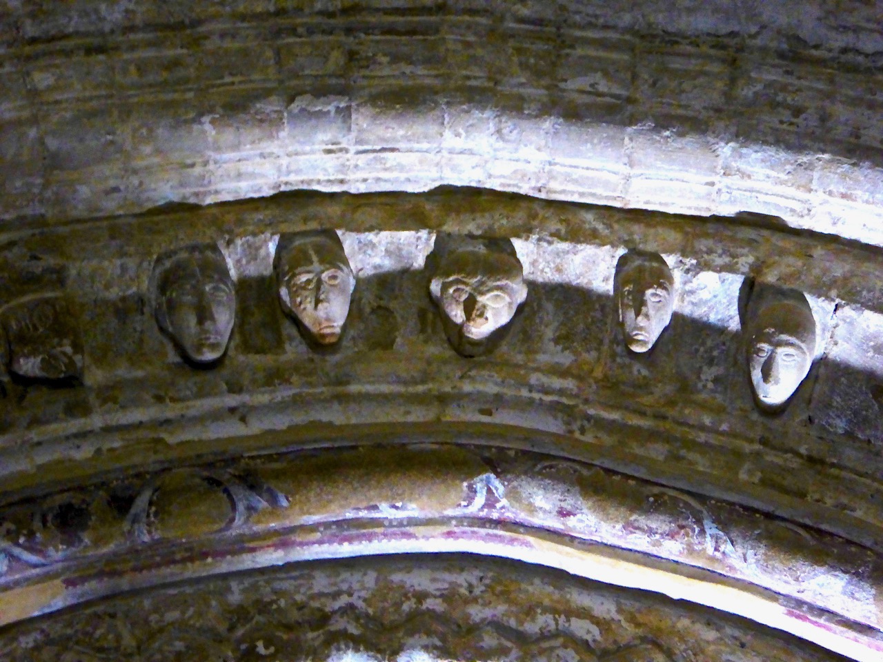
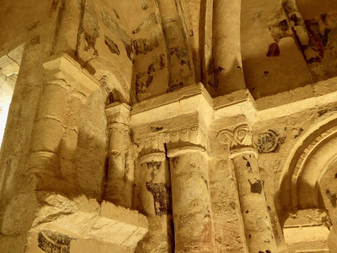
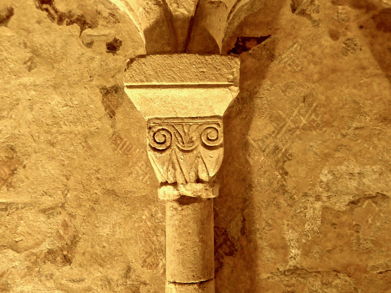
The arch is characteristic – three orders with carvings on both the arch and on the jambs, which are slightly inclined. The capitals are scalloped. The decoration is similar to that on the main door, indicating it was probably carved at the same time and maybe by the same hands.

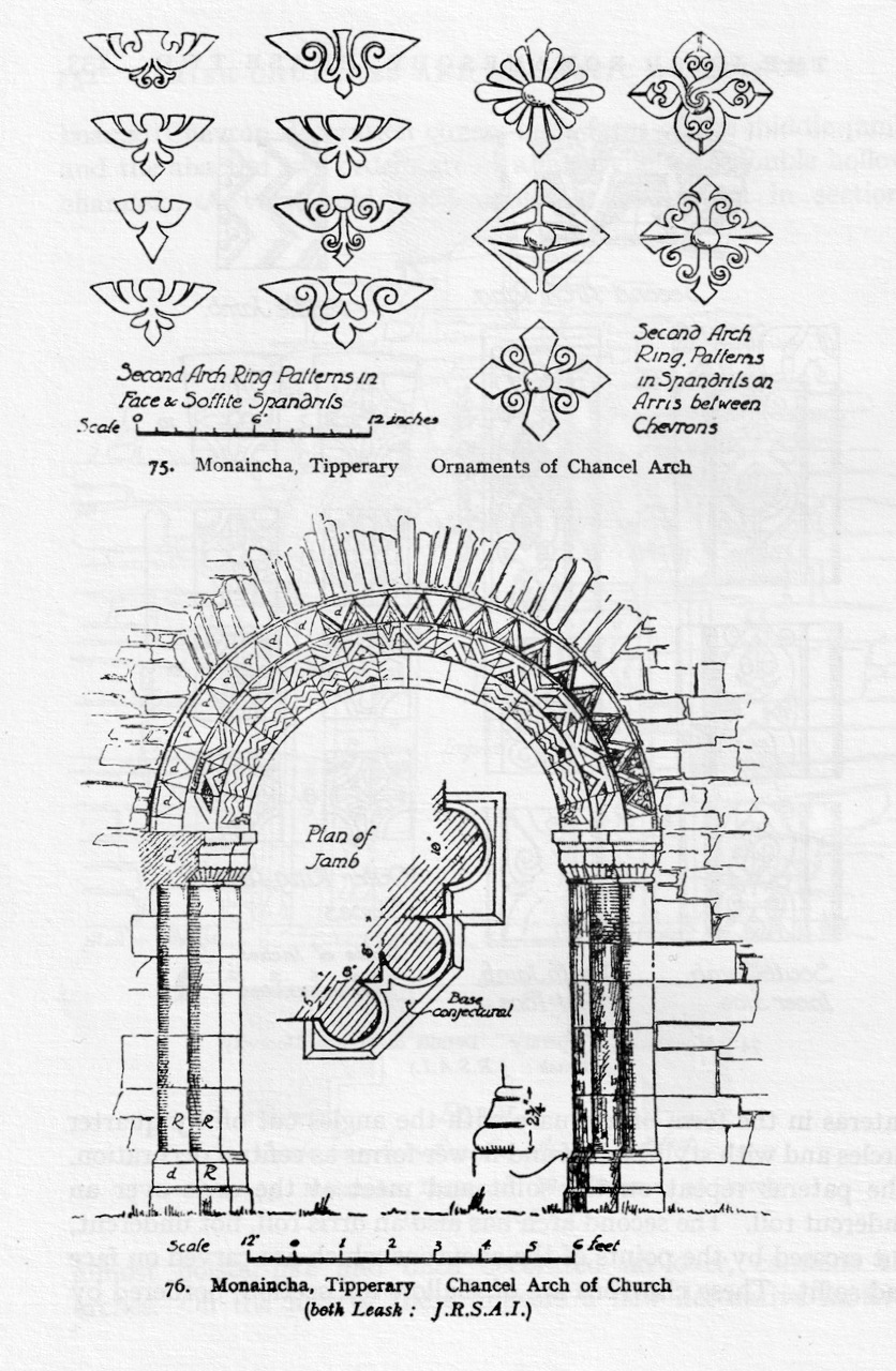
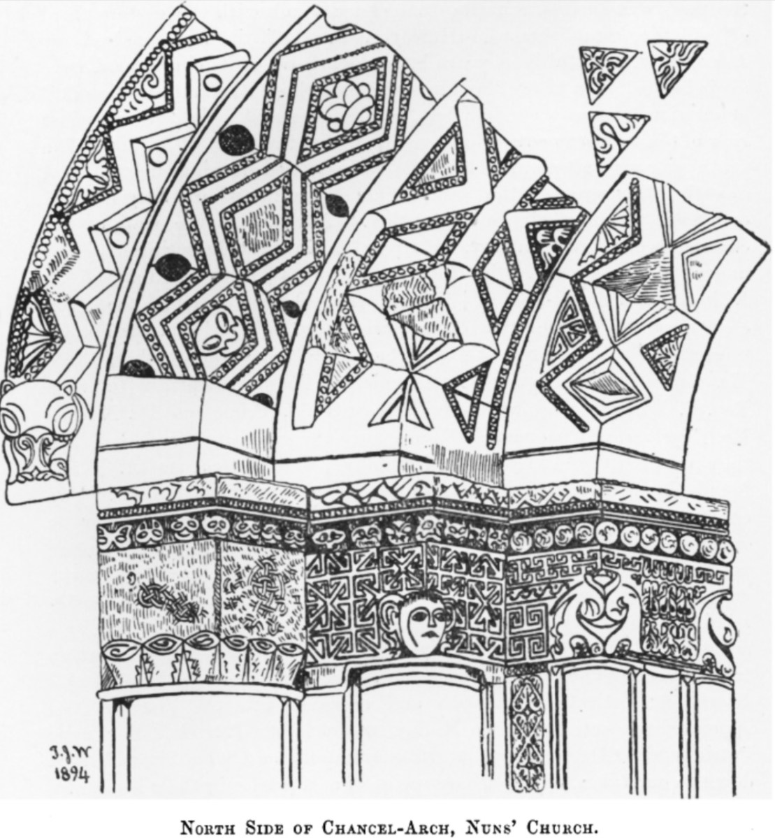
The experts at the Corpus compare the carvings to the Nun’s Chapel at Clonmacnoise and say, The squared patrae on the outer order of the doorway find an almost identical parallel at Clonfert (Galway), although at Clonfert the floral decoration of the motif does not vary. The closest comparisons to the chevron ornament are found at Killaloe and Tuamgraney (Clare). These comparisons suggest a construction date of c.1180, perhaps to coincide with the establishment of the Augustinian canons at the site.

Another view of the chancel arch, this time from Archiseek

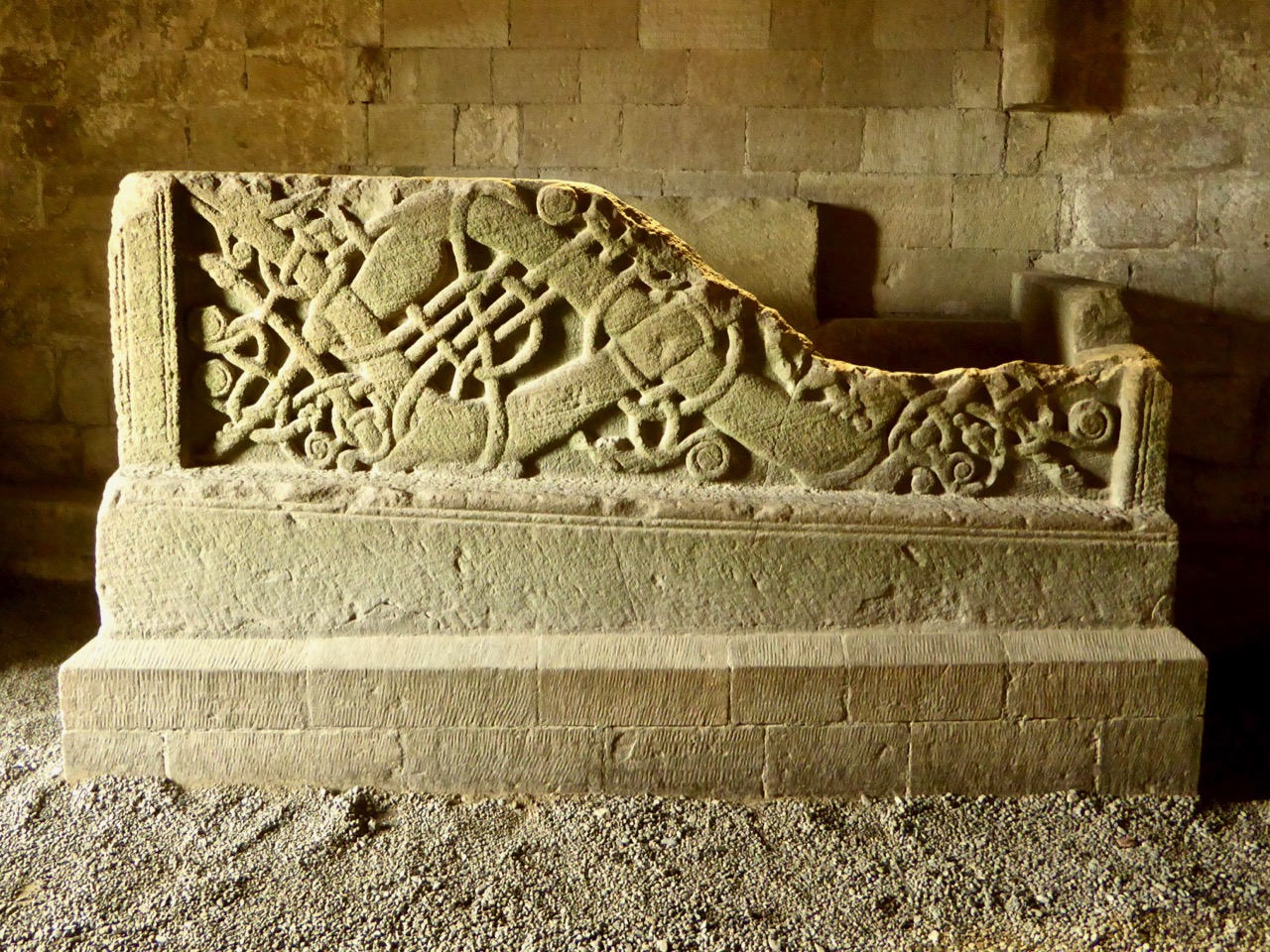
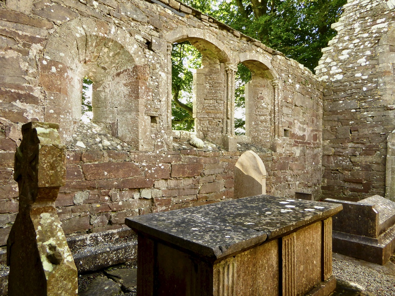
The ground floor of the sacristy is vaulted and contains tombs. This one memorialises A Sincere Friend and An Humble Christian and dates from 1832

The vaulted sacristy was added in the 15th century (Leask comments on the inferiority of its construction) and several other later modifications are visible to windows. There are  now no other buildings on the island, and of course no trace of the second island or of any other structures that one would associate with a 12th century monastic settlement, such as a round tower or an enclosing circular wall.

No matter – what is there is magical. We spent so long at Monaincha that the light was declining as we were leaving. It added to the atmospheric feeling of the place, and a sense that we were travelling back to ordinary life from the storied Isle of the Living.

In this, I share the emotion with Harold Leask, whose love of this site shines out in his writing. In his book he states, Perhaps no other church ruin in Ireland is so attractive in site, interesting detail and appearance. . .  In the Architectural Notes that follow the JRSAI history he writes, I first saw it. . . upon the afternoon of a summer, its walls golden in the rays of the westering sun, the little green mound with its circling wall and groups of beech trees forming a perfect setting in the level bogland, bright with ragweed and and bordered in the distance by woods. The whole effect was very suggestive of a Petrie water-colour sketch, with just that delicacy and precision which is the great charm of his work.

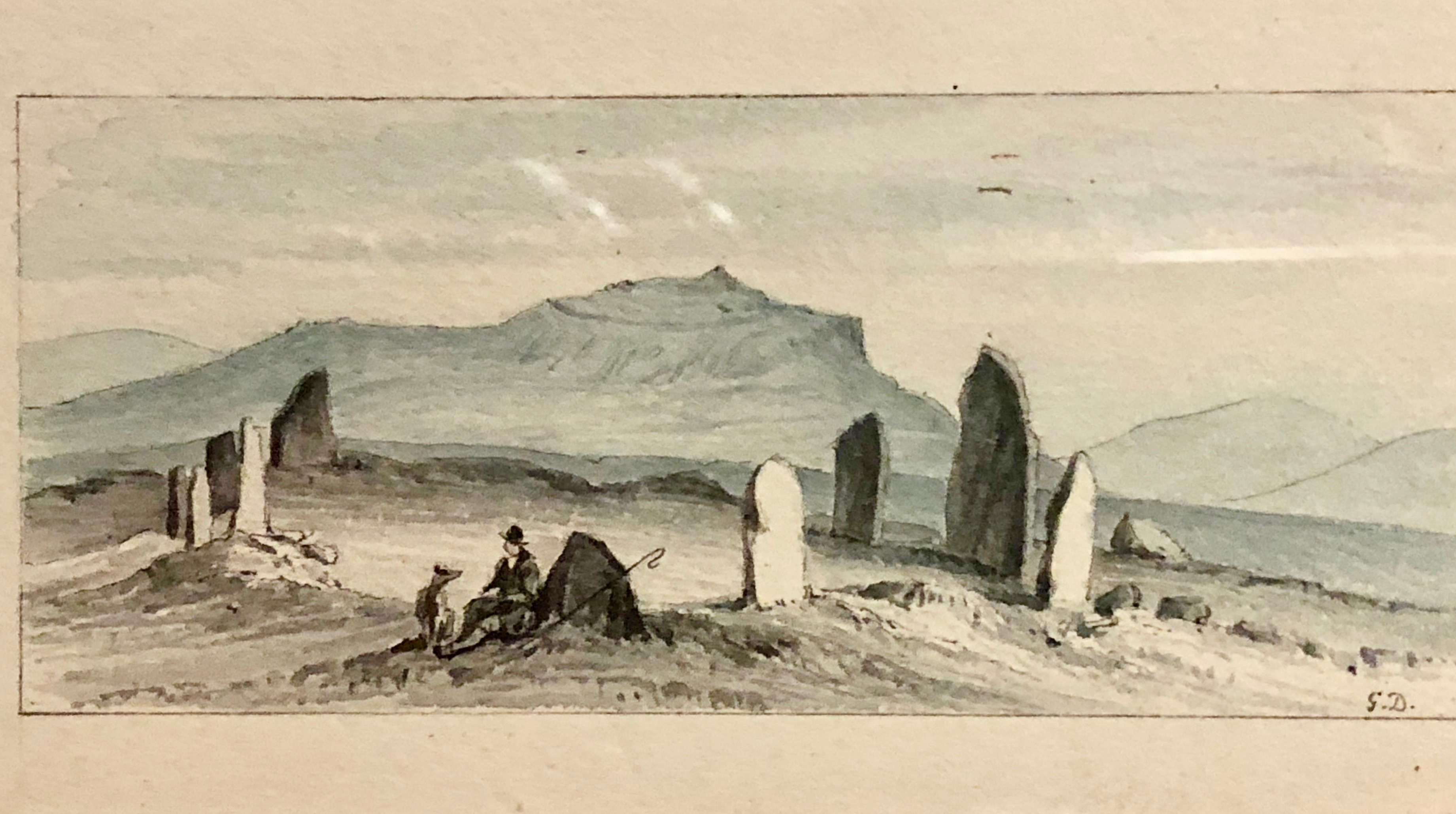
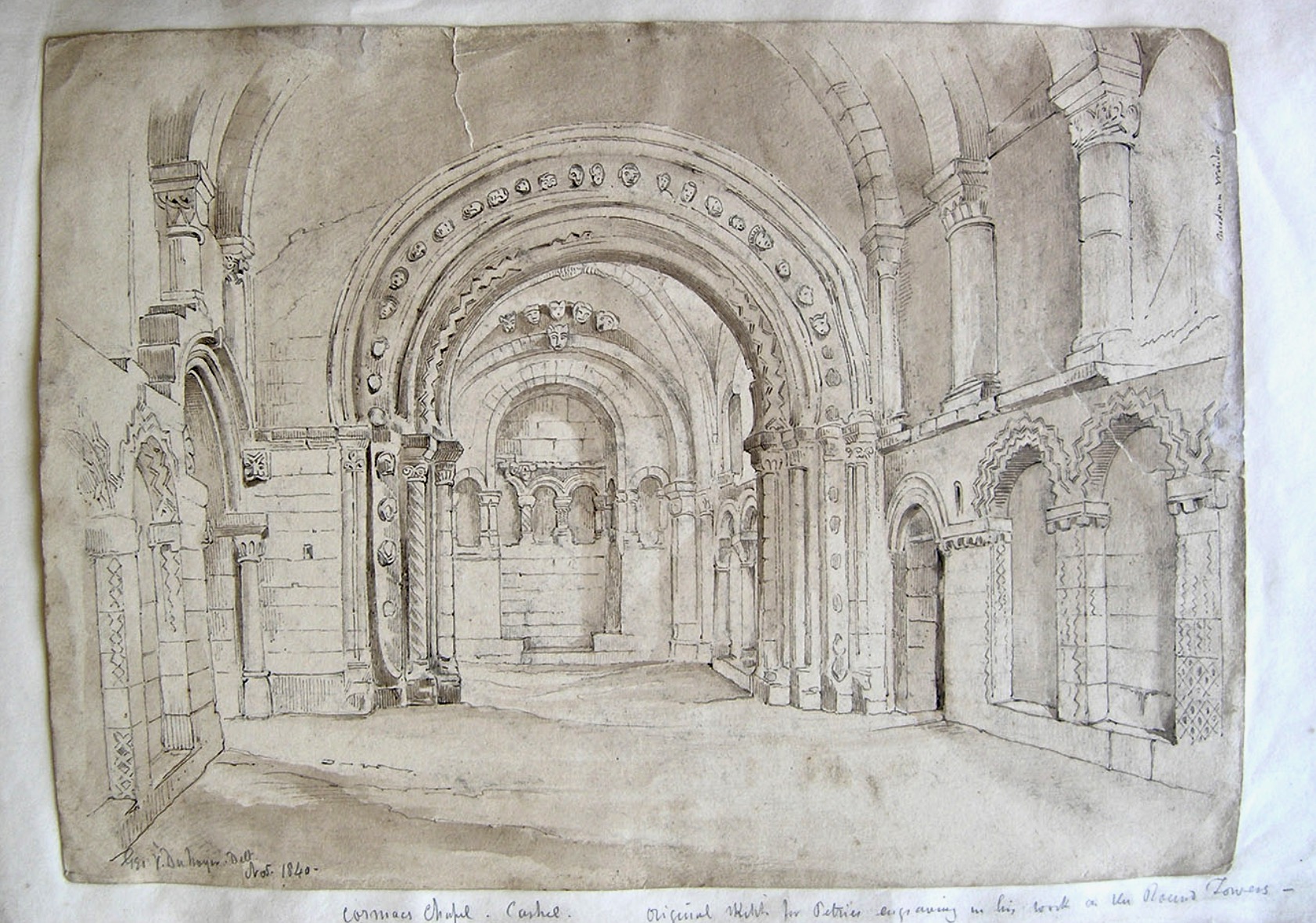
Leask may have been thinking of this very sketch by our old friend George Victor Du Noyer from a drawing by Petrie. It is marked ‘unfinished’ and indeed the sacristy is entirely missing**

*McNeill, C., and Harold G. Leask. “Monaincha, Co. Tipperary. Historical Notes.” The Journal of the Royal Society of Antiquaries of Ireland, vol. 10, no. 1, 1920, pp. 19–35. JSTOR, www.jstor.org/stable/25514550. Accessed 16 Feb. 2020

**George Victor Du Noyer, “Ideal Irish Church from a colour drawing by Geo: Petrie. Monaincha. Unfinished,” Royal Society of Antiquaries of Ireland, accessed February 16, 2020

More about Irish Romanesque Architecture:

Irish Romanesque – an Introduction

Irish Romanesque 2 – Doorways

Cormac’s Chapel: The Jewel in the Crown (Part 1)

Cormac’s Chapel: The Jewel in the Crown (Part 2)

Off the M8 – Kilree Monastic Site

The Stone Circles of West Cork: An Introduction

Southwest Munster, and West Cork in particular, is home to the greatest concentration in Ireland of stone circles. There are two main kinds recorded in the National Monuments website, each making up about half the total number of circles – the multiple-stone circle and the five-stone circle. (There are also a small number of enigmatic monuments called ‘four posters’ which share some features with stone circles, but I will write about them some other time.) 

Peter Clarke’s illustration of the Ardgroom Stone Circle on the Beara, from his online journal, Hikelines

The division based on the number of stones is somewhat arbitrary, since both share most other features. Both have uneven numbers of stones – five in the case of the five-stone circle, and seven or more (up to 19) in the multiple-stone circles.

Our old friend Du Noyer loved to illustrate antiquities. We’re  not quite sure which stone circle this one is**

Both types are axial or recumbent stone circles. The name recumbent comes from the lowest stone in the circle, the only stone set on its side, with its long axis parallel to the ground. All the other stones are set upright and they often increase in size from the recumbent to the portal stones. The portals appear to form an entrance into the circles and are sometimes set end-on to the circle. An axis drawn from the point between the portals to the middle of the recumbent bisects the circle – hence the name axial stone circle. All these features can be seen in the photograph of Drombeg Stone Circle (below).

While the multiple-stones circles appear roughly circular, they may have been laid out using more complicated geometry than the string-marking-out-a-circle technique. Some are more elliptical than truly circular. The five-stone circles, given the dominance of the recumbent, are actually D-shaped.

The five-stone circle which is part of the Kealkill complex

Many of our stone circles have disappeared over time, with only folkloric memory indicating that here was once a circle of stones. Some have lost stones over time, while in others uprights have collapsed. Whole monuments have vanished into forests or dense undergrowth. Even where we still have partial circles it can be difficult to make out which are the portals and which the recumbent.

Upper: Labbamolaga – we think this was a stone circle but so few stones remain that it’s hard to be definitive. Lower: This sad little heap of stones is all that remains of the Ahagilla Stone Circle. The recumbent is to the left and a portal to the right.

The circles are constructed from local stone and in some cases it is easy to see where they have been quarried from nearby rock outcrops. There is no evidence of the builders transporting the stones from elsewhere, with the exception, perhaps of the quartz blocks which are found occasionally either as uprights or associated with the circle inside or outside it. Although quartz is found in abundance in West Cork a large block of it may have been especially prized and reserved for such a situation.

This sizeable quartz block lies beside the Lettergorman Five-Stone Circle

The circles were carefully and deliberately constructed: Fahy’s excavations at Drombeg and Reenascreena shows that the ground was levelled.  Stones were, it seems, selected for shape as well as size. The recumbent is usually flat on top, which may indicate the side closest to the parent rock from which it was split. Some may well have been deliberately shaped by knocking or splitting off sections – we often notice, for example, how well certain uprights mirror the landscape behind them, like the one at Ardgroom, below.

Stone circles are often associated with other monuments, most commonly boulder burials and standing stones, and at least two have radial stone cairns beside them. Some of the standing stones appear to function as outliers to the circle, extending alignments towards solar or lunar orientations (more of that next time).

Upper: This boulder burial is part of a complex of monuments at Bohonagh which also includes a stone circle (visible behind the boulder burial), a cupmarked stone and a standing stone which is no longer to be found. Lower: A standing stone pair (one fallen) at Knocknakilla with (behind it) a five-stone circle (recently fallen over) and a  radial stone cairn – of all the elements of this complex only this standing stone is really visible in the landscape

West Cork stone circles, from the sparse excavation evidence, date from the middle to late Bronze Age (about 1500 to 600BC). They are commonly found on elevated ground with a clear and expansive view southwards, but stretching from the northeast to the southwest – that portion of the sky in which both the sun and the moon rise and set.

This tiny monument is a five-stone circle at Inchybegga. When the grass grows tall enough you can’t see it at all

Our stone circles have always fascinated antiquarians, happy to label them ‘druidic temples’ or make outlandish claims about their construction by visiting Egyptians. Some of the older illustration owe more to the imagination than to accurate depictions.

Templebryan Stone Circle as it actually is (lower) and as depicted by the antiquarian, Clayton, in 1742 (upper). The illustration for Clayton, done by Ann la Bush, shows the fashionable preoccupation at the time for Egyptian-type obelisks. Nevertheless it is important in that it shows that there were more stones in the circle than there are now. Note the central block of quartz

In more recent times, they have been the subject of a great deal of new-age speculation about long-distance ley lines, mystical ‘energies,’ extra-terrestrial builders, associations with pagan goddess cults and the like. As an archaeologist, I think this is a pity, in the sense that these stone circles are fascinating enough as they are – they embody so much that we need to understand about the scientific knowledge, advanced construction technology, and social organisation of the builders. The belief systems that underlie their reasons for constructing these monuments are equally important and more difficult to discern after the passage of millennia, but should be based on close and serious study of the monuments themselves.

Above is the Derreenataggart Stone Circle on the Beara, and below is a much more romantic and monumental rendering of it from Francis Grose’s Antiquities of Ireland (1790s), illustrated by Daniel Grose. My lead image is also a Daniel Grose illustration, this time of a stone circle that once stood on the slopes of Hungry Hill, but which has since disappeared*

The next post in this series will be about the multiple-stone circles.

*The two illustrations by Daniel Gross are from Daniel Grose (c.1766-1838). The Antiquities of Ireland, a supplement to Francis Grose, by Roger Stalley, Irish Architectural Archive 1991
**I now know that this is almost certainly not a West Cork example but Boleycarrigeen in Wicklow (thanks to Ken Williams for the ID)

Off the M8: Fethard Walled Town

Fethard is nestled snugly in Tipperary’s Golden Vale, famously rich agricultural land, and is nowadays well-known for raising legendary race horses. But it also happens to be the town in Ireland with the most intact set of medieval walls. The map above (taken from Fethard’s Conservation and Management Plan) shows how the town would have looked in the 1850s when George Victor du Noyer came through.

We drive the M8 often and we’re always looking for ways to vary the journey, so this post is part of our ‘Off the M8’ series. Fethard is an easy detour: if you’re heading north, leave the M8 at Exit 10 just after Cahir and re-join it at Horse and Jockey or at Urlingford. You’ll be travelling along lovely quiet roads parallel to the motorway and depending on how much time you spend in Fethard, the whole detour should add a couple of hours (or maybe three) to your journey.

Fethard also happens to have some lovely old shop fronts. This one dates to 1770

We started off at the visitor centre in the old Tholsel, or Town Hall. It’s been nicely restored and features an excellent audio-visual presentation, and upstairs many colourful explanatory panels. The staff was friendly and very informative, with an obvious passion for their town and its history.

From the Tholsel Visitor Centre, you look down over Trinity Church and the walls

The town was founded around 1200, and walled soon after, when Edward I granted the right to raise money through what was known as ‘murage grants’. This continued over the next couple of centuries, in fact most of the walls were built (or rebuilt) in the 15th century. We tend to think of town walls as primarily for defensive purposes, and indeed the town was attacked on more than one occasions. But walls were also important demarcations of commerce. The market was held within the walls and according to Tadhg O’Keefe (in the Irish Historic Towns Atlas):

The walls were a barrier through which those wishing to trade in Fethard had to enter, so they articulated, especially with guarded gateways, the differences of privilege and opportunity between those who lived within and those who entered from without.

There is only one gate left, the North Gate, which we actually didn’t see. But when our old friend Du Noyer came through in the 1850s there was still a gate at the west end of the town (below). It guarded the entrance at the bridge known as Madam’s Bridge and had what O’Keefe describes as a rare type of Gate incorporating a three story fifteenth century tower house.

Despite the walls, the town was attacked and burned on several occasion – but not (unlike so many Irish towns) by Cromwell! In fact, the town surrendered, under terms, and was spared the violent destruction that the Parliamentary army visited on so many other Irish towns. This doesn’t exactly make Cromwell popular in Fethard, in fact there is still a tradition in the town that ‘people will not go out the way that Cromwell came in’ so that funerals, for example, take a circuitous route to the cemetery to avoid retracing his tracks.

Like Youghal, the other Irish town with a significant extent of wall, there were tower houses along the wall, and within the town there were fortified town houses. Some are obvious and some are hidden behind more modern facades. Court Castle is one of the obvious ones, but the house next to it, known as the Watergate House, has a base batter that marks it out as fifteenth century (both images, below).

Within the walls and behind the Tholsel is Trinity Church. Because there is so much going on in and around it, I will quote the Buildings of Ireland summary in full:

Like the Town Hall and the Augustinian Abbey, the medieval parish church is a multi-period building of outstanding architectural, archaeological and historical importance. The church stands at the heart of the medieval walled town and the focus for the extraordinary number of late medieval structures arranged around the sides of the graveyard with rear entrances allowing direct access to the graveyard. The size and design of the church reflect Fethard’s prosperity in the medieval and early modern periods, the different types of windows, from different eras, emphasise the continuity of use. The impressive tower, that is highly visible for a considerable distance, is a particularly important and dramatic example of fifteenth-century craftsmanship, and is especially evocative of the medieval era as it stands picturesquely and appropriately inside the almost entirely intact medieval town wall and close to a impressively rare grouping of late medieval houses and almshouses. The interior has a finely crafted timber screen to the vestibule, and at the east end a stained-glass window with Eucharistic motifs, both highly decorative, and showing care and attention in the design as well as the execution. The recently timber roof to the nave, recently dated to of c.1489, is of exceptional importance as it is one of a small number of medieval roofs surviving in Ireland and is almost entirely intact.

Trinity, the graveyard and medieval church remains on the left and the town walls on the right

Unfortunately, the church itself was closed when we were there. It’s still very much in use, though, and there was some tidying up taking place in the graveyard. I’d like to go back for another poke around sometime.

Down by the Watergate we came across one of Fethard’s two Sheela-na-gigs. (See this post for more about the Sheelas). This one is typical – a female figure displaying her genitalia, but unusual in her emaciated form with ribs clearly shown, staring eyes and a grimace. We didn’t have time to see the other one, which means a) you (yes, you, Dear Reader) have to, and let us know and b) we have to go back.

We also met Fethard’s famous geese down here too, along with their owner. They are pets, he told us, but don’t go too near the male as he is guarding the female carefully at the moment as she is just taking a little break from sitting on eggs.

The walls are extensive, with long stretches very much intact. Edmund’s Castle and a mural tower known as Fethard Castle punctuate the wall on the river side.

I was fascinated by the flowers growing all over the walls. I expected Ivy-leaved Toadflax and Wallflowers, but it was fun to see Fairy Foxglove also: it’s an alpine plant and so it likes high rocky places. The only other place I have seen it here is on the Martello Tower at Illnacullen/Garnish Island, off Glengarriff.

Upper: Fethard Tower, with Trinity Church bell tower behind the wall. Lower: Fairy Foxglove growing high on the wall

Because it also happens to be the end wall of people’s gardens, the wall is breached here and there by entries to residences – not something I was expecting to see, and probably not something that would be allowed nowadays.

The wall is part of a living town, so it has not always been considered untouchable

We rounded out our visit with an excellent lunch at Emily’s Tea Room before resuming our journey. Fethard was a surprise – an amazingly intact slice of medieval history!

nnnn

Cormac’s Chapel: The Jewel in the Crown (Part 2)

I said I’d be back in a week and it’s been a year! I’ve been working my way through a series of posts on Irish Romanesque architecture (see the bottom of this post for the list so far) and last October I wrote the first of a two part post on Cormac’s Chapel, the Romanesque jewel on the Hill of Cashel in Co Tipperary. Since this is part 2 (unless you’ve read it before and have an amazing memory) go back there now and read up on the Chapel and its history, as well as my detailed description of the exterior.

Illustration by W H Bartlett from The Scenery and Antiquities of Ireland by Joseph Coyne and Nathaniel Willis

Right, done that? Great, then come on inside. I was fortunate to visit Cashel last year, when the Chapel was open and I could spend as long as I liked taking photographs inside. This followed many years when it was closed – a conservation measure necessary to address the dampness which plagues stone-roofed buildings. During this open period it was noted that the number of visitors, all emitting carbon dioxide, was having a detrimental effect on the interior, so now it is only accessible during a guided tour and for a limited stay inside. Hopefully, this post will help you see things that you might miss during a short visit, or even items that those excellent guides might not cover.

The interior, looking towards the chancel

This was a royal chapel, used for high ceremonies and built to enhance the prestige of King Cormac. When we think of such edifices, our mind probably pictures a cathedral, but large churches were still in the future in Ireland in the first half of the twelfth century and Cormac’s chapel, although small by European standards, was not outside the normal dimensions of Irish churches of the period. What was important was not its size, but the extraordinary attention to detail and decoration that went into its construction. Moreover, it had a second storey, under the steeply pitched roof. Although we are not completely sure what the functions were of that upper level, it effectively doubled the space available to its users.

The north wall – note the blind arcading and barrel vaulted celing with parallel ribs, and the ornate door that leads to the second storey

Inside, the chapel is a nave and chancel structure, common among Romanesque churches, the only difference being the altar projection at the end of the chancel. The upstairs is accessed through the two square towers (see Part 1) and an ornate door in the north wall opens to a spiral staircase leading up to that floor (not accessible to the public). The size of this door and its elaborately carved orders speaks to its importance in some ceremonial way – O’Keefe says it tempts us to imagine the enactment inside Cormac’s Chapel of some ritual of procession involving relics.* In contrast, the north and south doors, the main entries to the nave, which are ornate on the outside, are relatively plain on the inside.

The nave is barrel vaulted, with parallel ribs running across the ceiling. The walls have blind arcades up to half their height, topped by a string course and a series of columns to support the ribbing. The blind arcade arches are carved with chevrons (above) while the columns between the arcades have irregular checkerboards of chevrons, lozenges and petals (below). The west wall has three windows on its upper stage, although only the middle one admits light now.

Beneath those three windows is a fragment of a large stone box, often described as a sarcophagus, wonderfully carved in the ‘Urnes’ style – a Scandinavian tradition of intertwined animals. Tradition has it that this is the tomb of Cormac himself, and certainly this carving style, although very different from what is found in the rest of the chapel, is probably contemporaneous with it. It was moved to the chapel from the later, Gothic, cathedral, where it was found. Whatever its use, it is a magnificent artefact, the work of a master craftsman.

At the east end of the nave is the chancel arch with four orders. The archivolts of the first order mainly consist of carved heads, each individual and striking. Some are more time-worn than others, but the features can be clearly discerned in many.

The chancel is also rib-vaulted, like the nave, but this time the ribs intersect at a central point, rather than being parallel. Like the nave, the walls have blind arcading above which are further arches and window-openings. Capitals are decorated with scrolls and scallops.

A final arch spans the projection which held an altar. The arcading in this final section is quite elaborate, and two deeply splayed windows provide light to this area.

Once in the chancel area, which has been well lit, you can start to appreciate the vestiges of paintings that would have enlivened the interior of Cormac’s chapel. A conjectural reconstruction of the artwork is provided in an explanatory panel – the chapel must have looked magnificent and colourful indeed. Preserving these precious fragments has been a tremendous effort.

Finally, stand in the nave and take a careful look around – you will see that the chancel is offset to one side of the nave. While some authors have suggested this as a decision to change dimensions midway through the building process (Dermot Bannon’s nightmare) and others have ruminated about mistakes, O’Keefe demurs. It makes a lot more sense, he says, to interpret Cormac’s Chapel as built to plan, and to suggest that the nave widens on the north side to reflect and accommodate the visual spectacles of procession involving both north-side doorways.

Sketch by Richard Lovett, from his Irish Pictures. The ‘offset chancel is clearly seen in this illustration

There you have it – the glorious high point of Irish Romanesque architecture inside and out. If you haven’t been to Cashel yet, there’s a treat in store. And if you have, well, go again, and make sure to sign up for the guided tour that includes Cormac’s chapel.

The interior of Cormac’s Chapel sketched by George Victor duNoyer for George Petrie**

Previous posts on Irish Romanesque architecture

Irish Romanesque – an Introduction

Irish Romanesque 2 – Doorways

Cormac’s Chapel: The Jewel in the Crown (Part 1)

*Once again, I relied heavily on Prof Tadhg O’Keefe’s manuscriptRomanesque Ireland: Architecture and Ideology in the Twelfth Century, which he has generously uploaded to Academia.

**George Victor Du Noyer, “Cormac’s Chapel Cashel. Original sketch for Petrie’s engraving in his book on the Round Towers. Geo V Du Noyer. Delt Nov 1840,” Royal Society of Antiquaries of Ireland, accessed October 21, 2018, http://rsai.locloudhosting.net/items/show/22213