That’s what happens when you sit down to write – you start out intending to accomplish several objectives but end up getting so caught up in the first, that that’s all you write about. It’s what happened to me in Under Sorrow’s Sign: I meant to go through the whole six issue of Ireland of the Welcomes for 1971, and do a single post about all the articles in them about Irish Literature. My intention with this post is to cover the remaining five issues, in order from the oldest traditions to the newest. Let’s see how I get on.
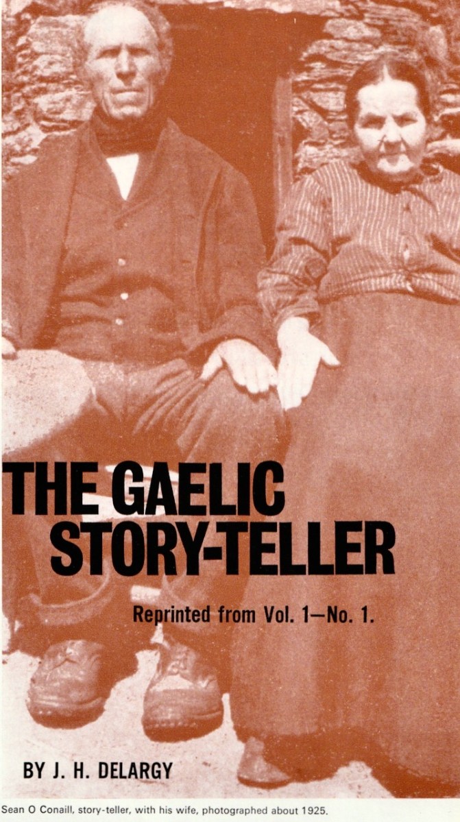
May-June 1972 includes The Gaelic Story-Teller, by J H Delargy. You can read a very entertaining biography of Delargy in the DIB, in which Eoin Mac Cárthaigh says:
It is no exaggeration to say that he was twentieth-century Ireland’s greatest folklorist. He was a driving force behind the belated recognition of the importance of Ireland’s fast disappearing folklore heritage – much of which, but for his efforts, would have been lost forever.
However, he also adds that his approach was not without its critics:
Nor did Ó Duilearga and his co-workers escape the satirical wit of Myles na gCopaleen (qv), who recounted in An béal bocht the happy tale of an academic building his reputation on a traditional story collected from one of the loquacious piglets of ‘Corca Dorcha’.
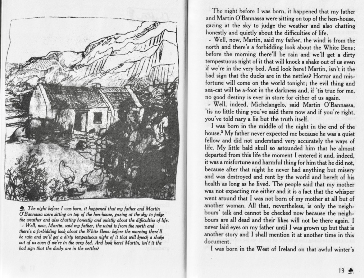
That, of course, sent me on a hunt to my shelves for my copy of The Poor Mouth (the English translation of An Béal Bocht), and an hour later I was still chuckling and trying to remember what I had set out to do in the first place. I apologise here to those not educated in Irish schools and made to read Peig and The Islandman in Irish – but for those who were, this will resonate. The illustration is from the Flamingo Modern Classic edition, translated by Patrick C Power.
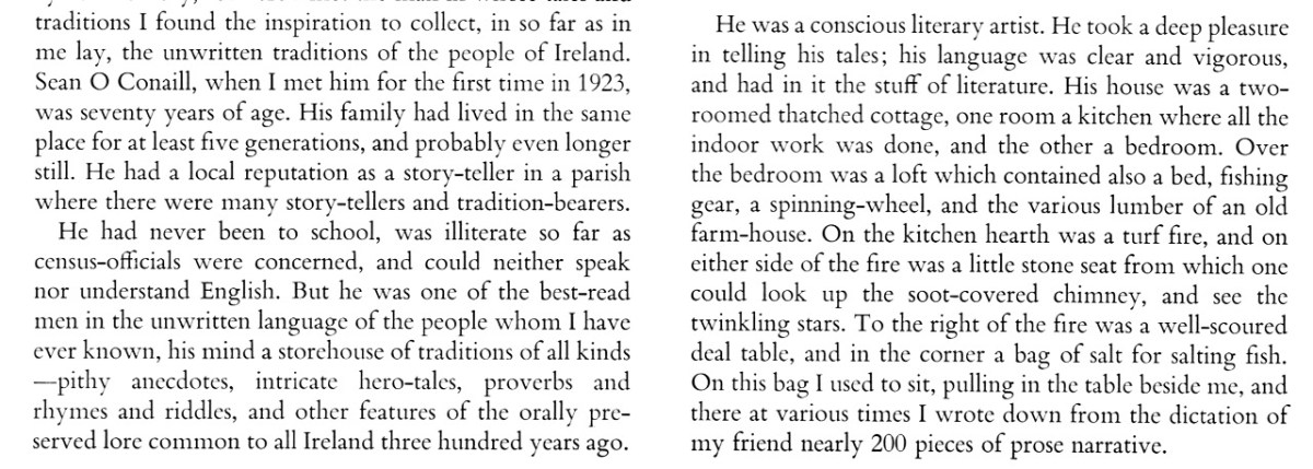
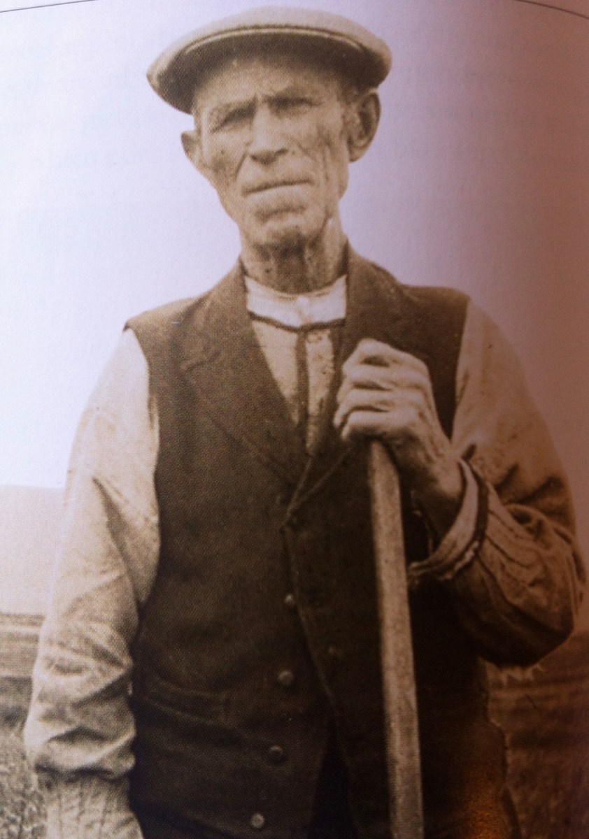
But to get back to Delargy’s article – it mainly centred on Sean Ó Conaill, the story-teller of the title. In a longer essay elsewhere, Delargy (that’s him on the left, above*) tells us that such a person
is know as a sgéalaí or a sgéaltóir, whereas the more common word seanchaí is applied as a rule to a person, man or woman, who makes a specialty of local tales, family-sagas, or genealogies, social-historical tradition, or the like, and can recount many tales of a short realistic type about fairies, ghosts and other supernatural beings.
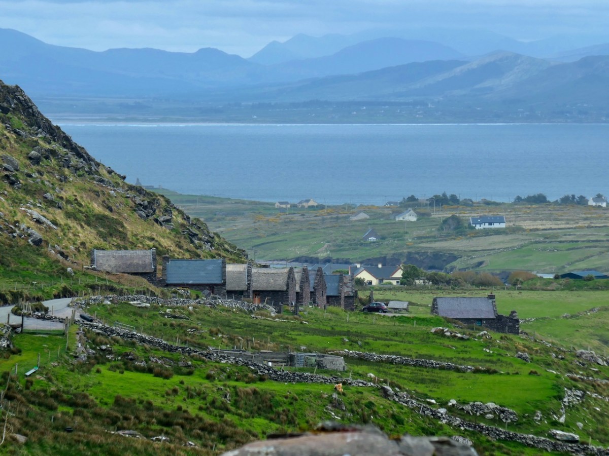
Delargy first met Ó Conaill in Cillrialaig in Kerry, when Ó Conaill was already 70 years old and Delargy, from the Glens of Antrim, was 24. Delargy calls Cillrialaig a village, but in fact there is nothing left there now that resembles a real village – except for a marvellous set of old houses that have been renovated for use as an artists’ retreat (below).
Delargy describes it thus:
It is a lonely windswept place where man has formed out of the rocks and rough mountain land a crazy quilt of tiny fields to grow his oats and rye, hay and potatoes.
Delargy starts his account of the Story-Teller in this way:
He married Cáit Ní Chorráin and they had six sons and four daughters. Cáit shared his passion for oral storytelling and was always on hand to correct him or remind him if he should lose his way while telling a story.
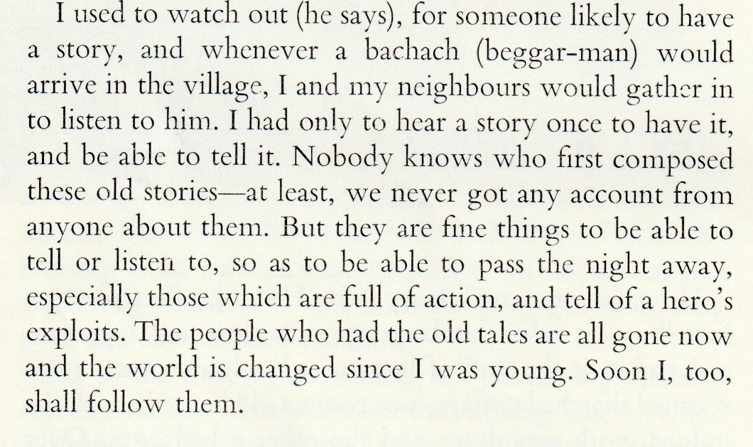
Delargy’s practice was to visit the Ó Conaill house three nights a week. While Sean dictated his tales (Delargy must have been a fast writer), the neighbours would drop by until the house was full, each listener relishing the stories, even though they had probably heard them many times before. How did O Conaill accumulate such a store?
Delargy’s article concludes with a lament for the dying of the old traditions – it is rare now, he says that stories are told around a fire in this way. Delargy himself died in 1980. If you’re listening, Séamus, you might like to know that there are now thriving story-telling festivals all over Ireland, principally on our own Cape Clear Island.
Darn it – it’s happened again! I only got to the May-June issue. Never mind – next time, I’ll cover four in one go. Right?
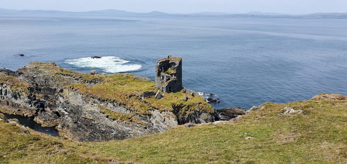
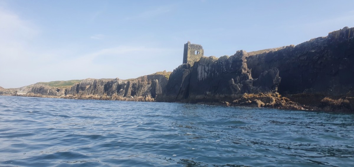
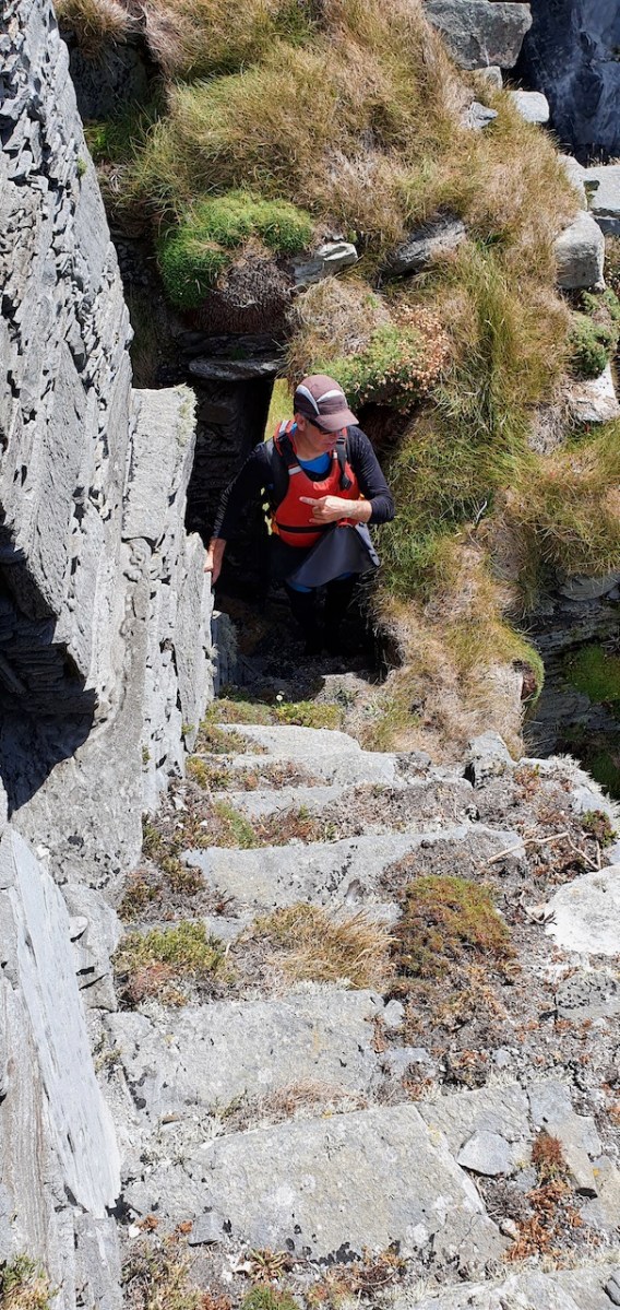
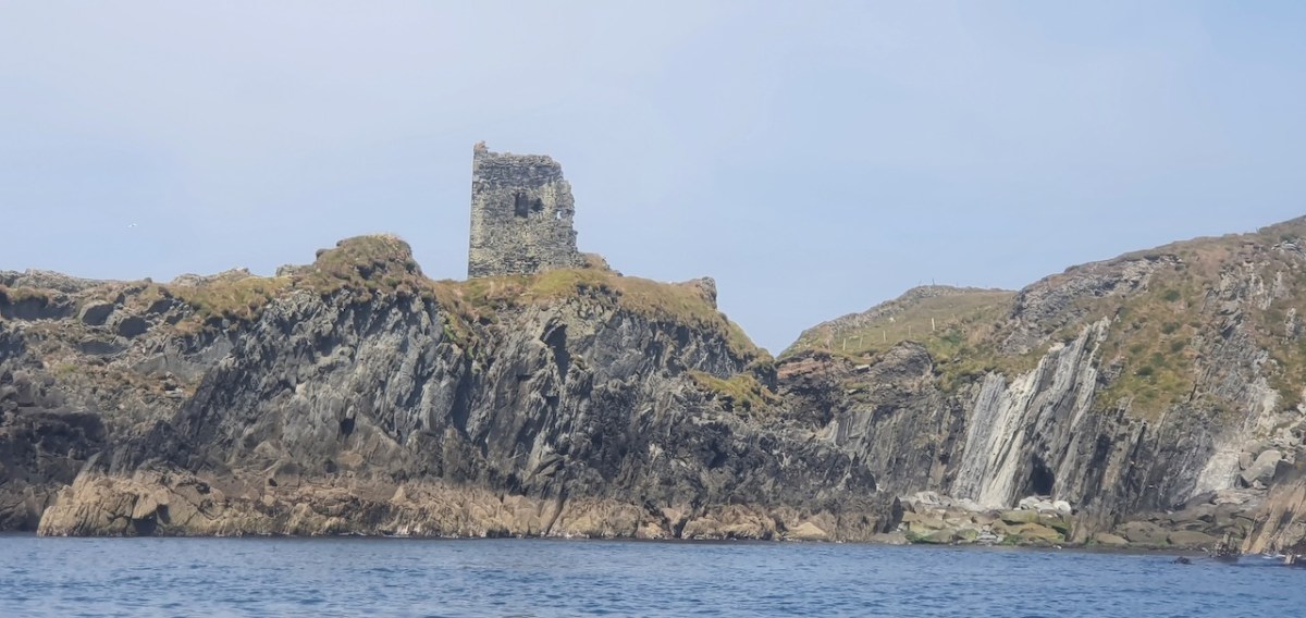
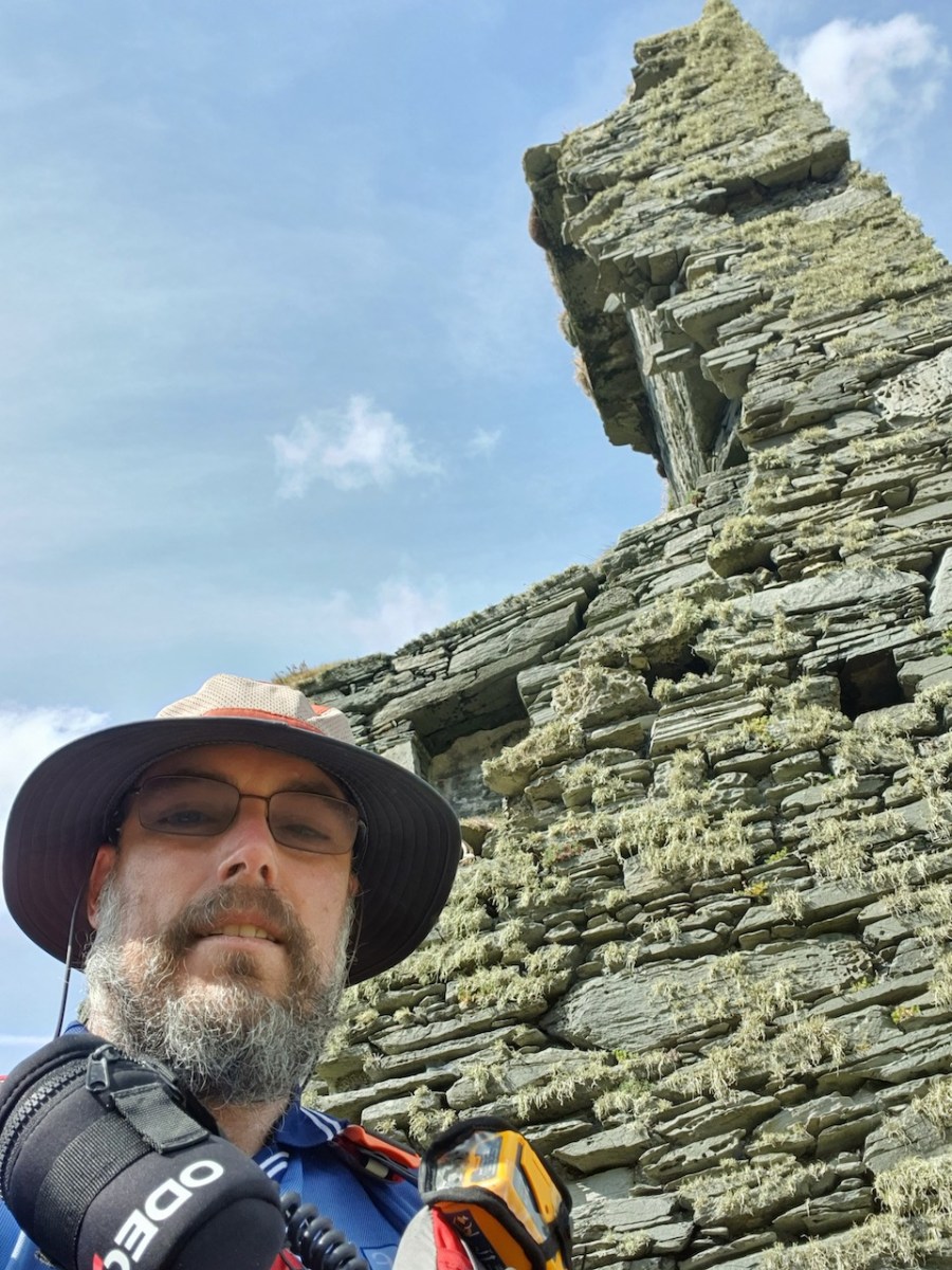
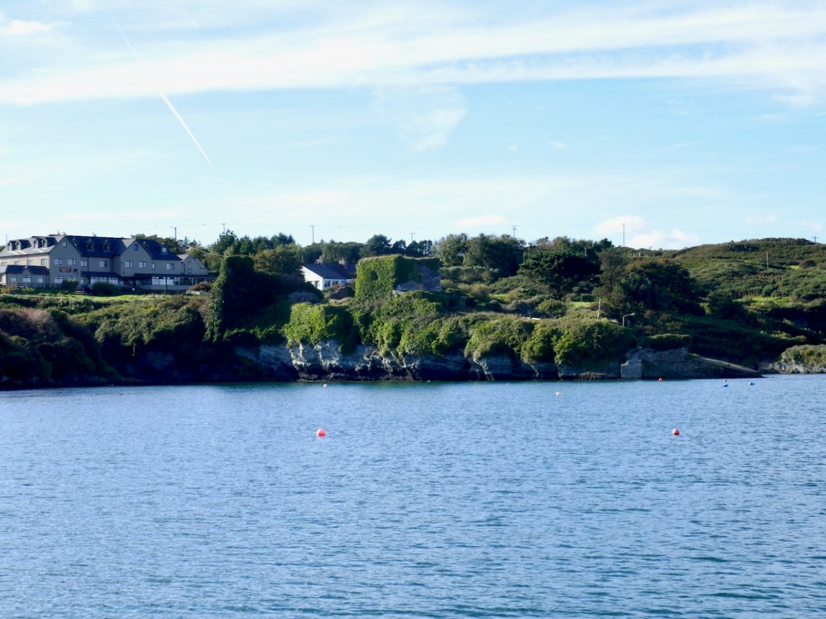
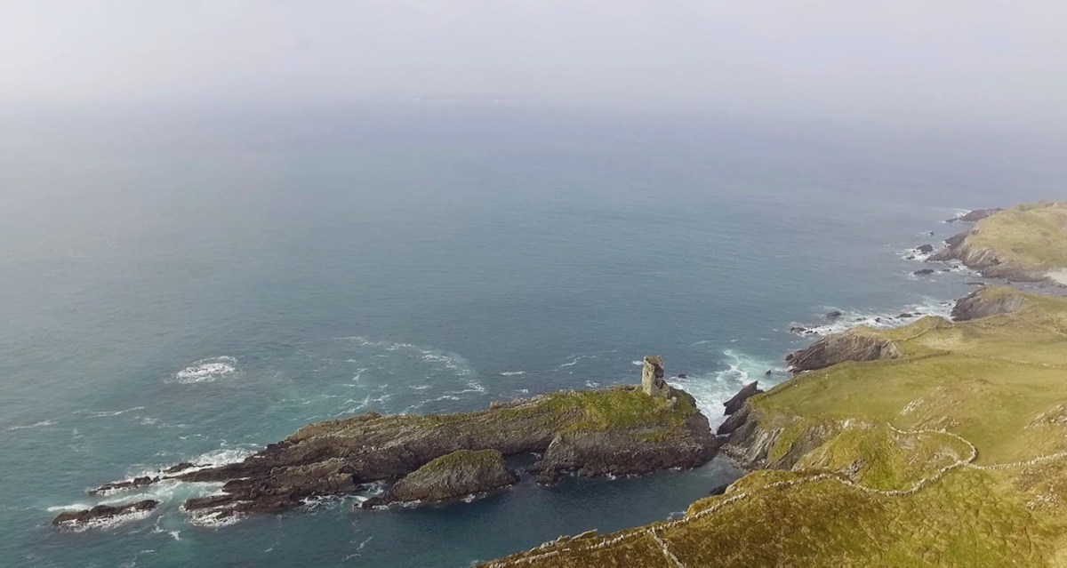
This post will be about the castle itself, as a follow-up to Part 1 about the promontory and historical background. I received some very interesting comments on the name, Dún an Óir, which I interpret as Fort of Gold, and I will write more about that at the end of this post. If you are not familiar with castle architecture, before you start, you might want to browse my castles page and pay attention to how they were built and what the castles of Ivaha generally looked like. Unless otherwise identified, all the photographs in this post were kindly sent to me by Tash, one of our readers. In this one, taken from the sea, the impregnable siting of the castle can be appreciated.
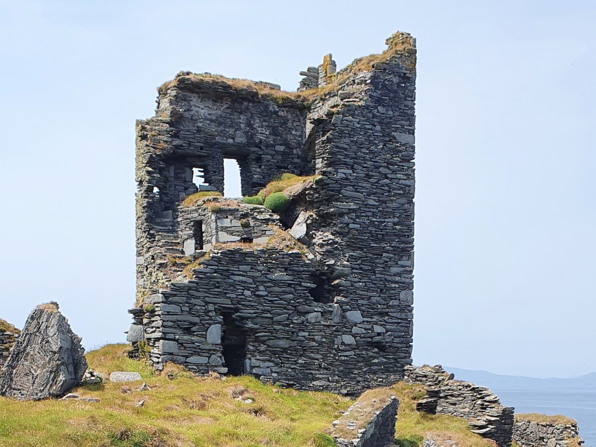
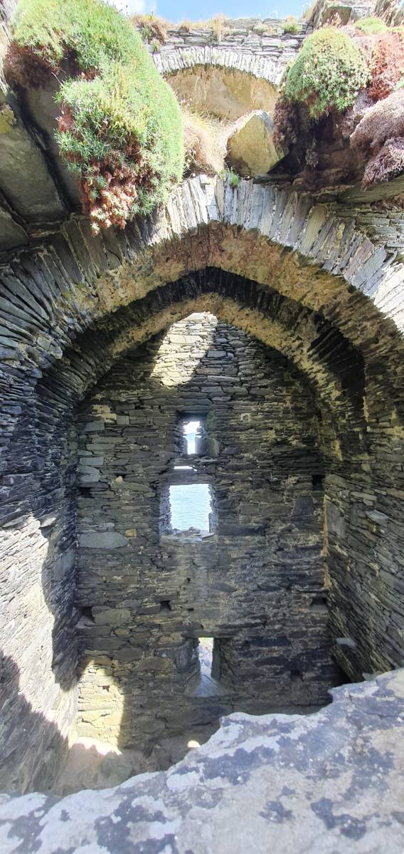
The castle was surrounded by a bawn wall, clearly visible still. Three floors (ground, first and second) were surmounted by a ‘partial vault’, above which was the principle chamber or solar – the private domain of the castle owner and his family but also where visitors were entertained. Above that was a mezzanine floor and above that again was a wall walk, accessed via a spiral staircase from the main chamber.
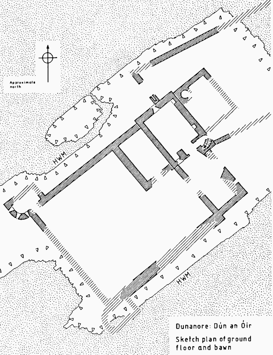
In her paper on this castle*, Sarah Kerr points out that it is, in fact, unlike the other O’Driscoll Castles of Dún na Séad and Dún na Long, and indeed other West Cork Castles, in that it only had one entry, at the ground-floor level. It is possible, she says, that the tower was so well defended naturally by its position, that a raised entry (an additional line of defence) was unnecessary. She also points out that a raised entry functioned as a status symbol, since it was the entry used by the chief to access the private rather than the public spaces within the tower. Perhaps Dún an Óir was therefore a lower-status castle, occupied by a garrison rather than by a chieftain. She provides this plan
Another unusual feature is the small projecting tower that contained the garderobes. You can see that projecting addition in the plan, above, and in the photograph, below. The entry led up, via a mural staircase to a door giving admittance to the first floor, and carrying on to entries at the second and third floor levels. From there, another stairs led up to the wall walk.
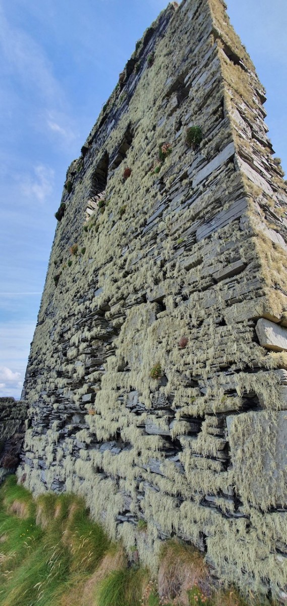
Flat slabs were used to dress the outside of the walls, the same construction method as at Dunlough, although not as finely built.
Instead of a complete vault, such as we see at Dunmanus or Rincolisky, there is a ‘partial vault’, described by Samuel:
Two free arches resembling ‘slices’ of a barrel vault were built. The gaps between the arches and the walls created were lintelled over with large overlapping slabs. This ‘economy’ vaulting was much lighter than a complete vault.
In fact, this type of internal vaulting is not that unusual in West Cork – we saw it at Dunlough and in the small tower at Dunworley. At Dunlough, we can still see many of the large slabs of slate that once bridged the gaps between the arches of the partial vaulting, while at Dunworley the roof is still intact. In Tash’s photograph below you can see the double arches and the full extent of the three floors below them, as well as the chamber above which would have had a pitched wooden roof..
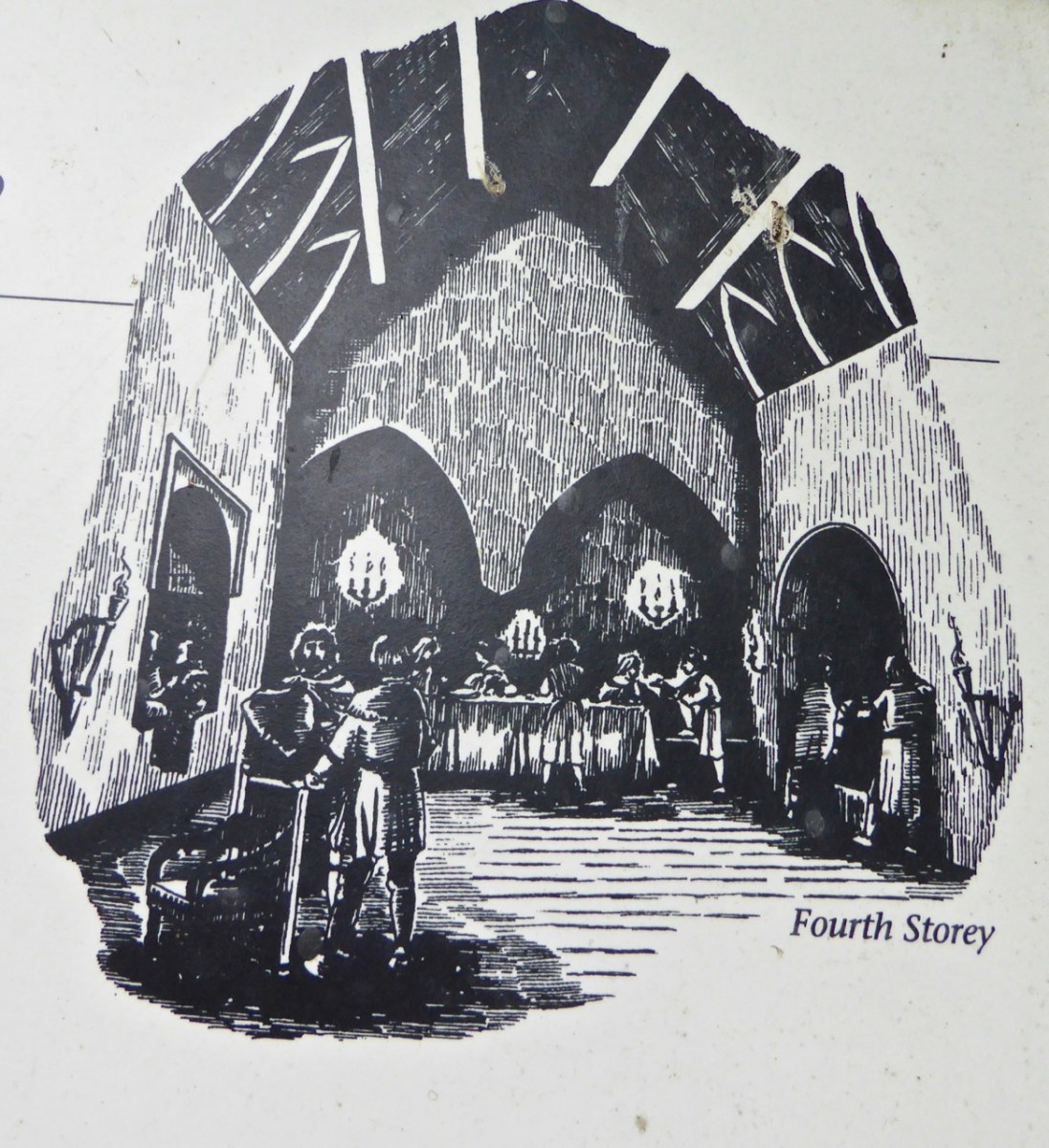
The top room, or chamber, was very high with a pitched roof supported at each end with an archway. The archway also allowed the top of the wall to be kept clear to form a wall walk. A conjectural reconstruction drawing at Ballinacarriga conveys the idea, although Dún an Óir only had one arch, not two.
Quite a bit of the bawn wall survives, although of course it would have been much higher (possibly as described here). If the sheer cliffs were not enough to deter any thought of attack, the walls would have provided an additional barrier. Unfortunately, they were not able to withstand cannon fire, let alone the passage of hundreds of years. Sarah Kerr has an interesting take on this wall:
Bawns are often considered an additional defensive feature, or at least deterrent. Dún an Óir’s in this regard is somewhat excessive as anyone who could scale the rocky façade of the promontory would likely not be deterred by additional few metres of wall. The bawn, however, would have provided the inhabitants a layer of safety against accidental falls and protection from some of the inclement weather, such as high winds and storm waves from which Roaringwater Bay gets its name. These humdrum practicalities of the medieval lived experience have often been overlooked in castleology or castle-adjacent buildings archaeology, however, it is this very granularity which deepens our understanding of how these buildings worked.
Networked Control: Tower Houses in Ireland by Sarah Kerr
The bawn, in Samuel’s estimation, (that’s his plan above) was big enough to accommodate quite a large herd of cattle. An interesting feature is that of an outside kitchen with an oven, reminding me of what was uncovered at Rincolisky, another O’Driscoll castle, in recent excavations. In the plan above the oven is the circular feature at the north corner of the tower. Other buildings stood inside the bawn, although their purpose is not clear. There may have been a gatehouse, and the ‘possible wall embrasure’ in Kerr’s plan is viewed by Samuel as a corner turret. Samuel lays out what he can interpret of the various walls that surround the castle:
The continuous and well-preserved north wall of the bawn terminates to the west with a return that runs a short distance north before being broken away. This is the inner face, a turret with gunloops which defended the bawn. The curved outer wall enfiladed the mainland with three widely splayed gunloops.
The interpretation of the ruins east of the tower house is more difficult. Erosion has removed the eastermost part of the defences. Two separate walls on the east side of the tower diverge from its orientation; running approximately due east they seem to have formed the north and south walls of a smaller enclosure containing another building. At the west end, the north wall meets a wall (the junction is destroyed) with a gate which abuts the north face of the tower. The robbed jambs of a large gate survive on the east face of the wall and indicates that the gate swung inwards to the west where another enclosure presumably existed. A deep drawbeam is visible in the south jamb. This gate now leads almost directly into a deep ravine. A fair-weather landing stage may have once existed on this side of the island but it would have rarely have been safe to use.
Sarah Kerr positions Dún an Óir in a network of O’Driscoll castles that together worked to control the resources of Roaringwater Bay, to levy fishery dues, monitor trade, and defend territory when necessary. Within this network, the highest status tower, and probably centre of administration was Dún na Séad (Baltimore). The highly visible nature of all these castles, some on promontories and all visible from the sea, were ‘manifestations of authority, wealth and status.’ She posits that:
Due to Dún an Óir’s lack of a slipway, natural harbour or rock-cut steps, it is unlikely that manging the fish produce was a primary role at this dwelling, particularly as Dún na Long and Dún na Séad were more suited to such tasks. Instead Dún an Óir probably managed the victualing and collection of fees from passing ships, indicating that the tower houses worked in unison. It appears that each tower house had a specific role which complemented one another, as such they were unique actors that performed as a network
Networked Control: Tower Houses in Ireland by Sarah Kerr
It’s surprising how much we can tell from the remains of this once prominent symbol of power. It will never be on a tourist trail and I would not advise anyone to try to access it – but as you can see, Tash and his group managed it.
In response to my first post I had several suggestions for alternate titles on Facebook. Ruamann Ua Ríagáin proposed an alternate interpretation as Dún an Ár, or Fort of the Slaughter. There are no indications that there was any tradition of cattle-slaughtering at this site, nor any record of a massacre. However, it remains a possible interpretation. Another reader, Tom Driscoll found another Dún an Óir which was assumed to come from Dún an Ochair, meaning Fort on the Brink/ Cliff Edge. Certainly apt for this location. Finally, note the long comment on Part 1 by OVERSEASGREATGRANNY who is trying to trace similarly named forts and relate them to Irish history – quite fascinating.
When the storms rage over Roaringwater Bay it is natural to wonder how long this castle can last, isolated on its spit of land and open to the full force of nature. But it is also a comfort to know that the castle builders built it so well that it has lasted now since it was built around 1450 and battered in 1601. Here’s to another few hundred years!
Thanks again for the superb photos, Tash!
Sarah Kerr of UCC has kindly shared with me her draft paper, Networked Control: Tower Houses in Ireland. I thank her sincerely for permission to quote from this unpublished paper.
I have been gifted with a marvellous set of photographs of Dunanore, or Dún an Óir – an O’Driscoll Castle on Cape Clear. The gift came from one of our readers, Tash, and I am very grateful indeed. Regular readers know that I like to use my own photos, and I do have some that I took from the sea (like the one below) but I have none of Dún an Óir from the land, let alone from the castle itself!
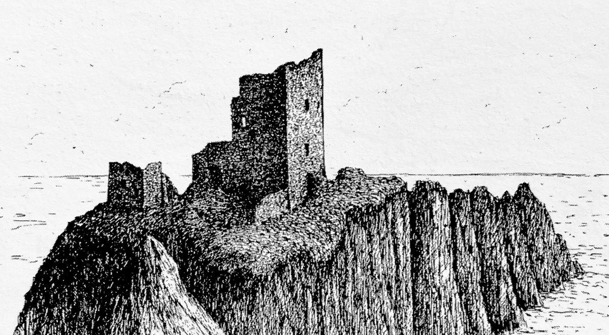
And that’s because, as you can see from the drawing by Jack Roberts at the top of this post, this castle is situated in a very perilous location, on the edge of a cliff, on a small island, essentially, making access a hazardous scramble up from a rocky beach. It was once connected to the rest of Cape Clear by a narrow causeway but this has long collapsed. It was still there in the 1770s when Charles Smith visited. In his The Ancient and Present State of the city of Cork Vol 1, he wrote:
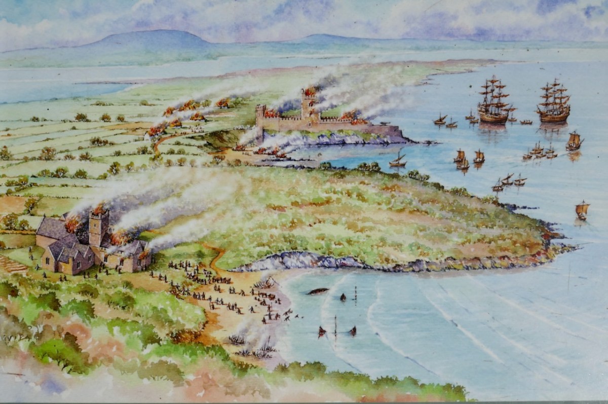
And this brings us to the name – Dún an Óir. It means, of course, Fort of Gold, and some of the old legends about this place talk about the name coming from stories of buried treasure. But in fact, this has been the name of this fort since the first maps of this area were made in the fifteen hundreds and it speaks to the wealth of the O’Driscoll clan who built it. Remember, their other stronghold, now called Baltimore, was Dún na Séad, or Fort of Jewels (on at least one map given as Castle of Perles). On Sherkin, their castle was Dúnalong – or the Fort of the Ships – that’s it as it is now, below.
There are many accounts of their fleets of ships, and the battles they waged against the Waterfordmen in which they came out the worst for wear when Dunalong was attacked. The scene below, from an information sign on Sherkin, shows the Battle of the Wine Barrels, 1537, with both Dunalong and the Friary on Sherkin in flames
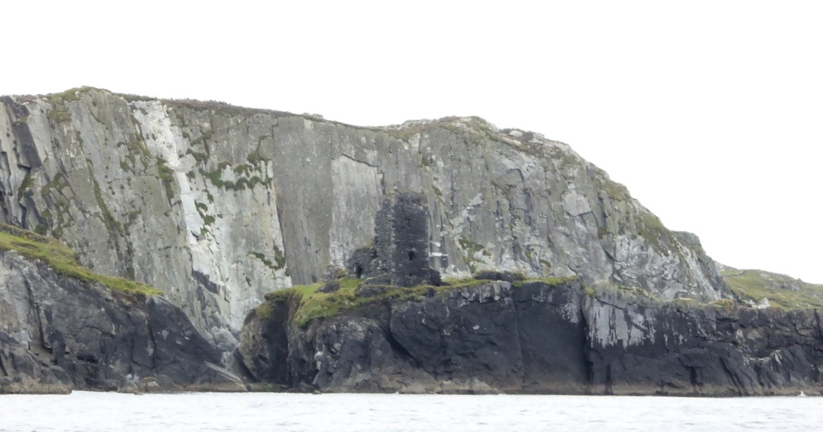
Dún means ‘fort’ but seems to be especially applied to promontory forts in the southwest. Before the castle was built, therefore, it is likely that the O’Driscolls fortified the headland, which may date well back to the Early Medieval period (400-1200) or even to the Iron Age (500BC to 400AD, or 500BCE to 400BC for those who prefer the secular version). The Illustration below is taken with permission from Dún an Óir Castle: an uncertain future, by Dr Sarah Kerr, and shows the present state of the castle, marooned on what was once a promontory connected to the Island.
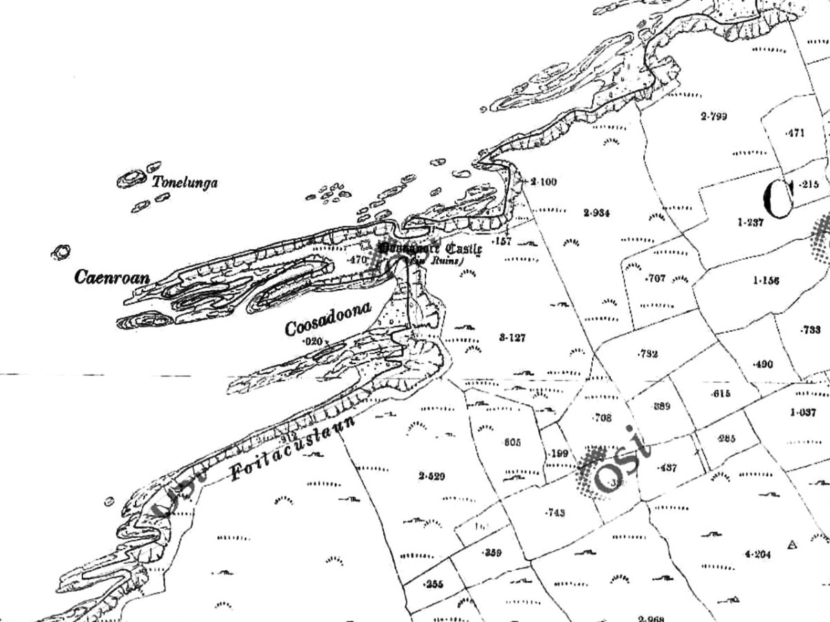
Our Promontory Fort man is Thomas Westropp (see here and here), and he wrote about Dún an Óir in his 1914-16 paper for the Royal Irish Academy, Fortified Headlands and Castles in Western County Cork. Part I. From Cape Clear to Dunmanus Bay. He visited the site, but like many a good explorer before and after him, did not venture out onto the promontory, but satisfied himself with what he could see from the high ground above it. That included the promontory and ruined castle, the rather ominously named Tonelunga (The sea-bed of the Ships), the end of the promontory called Caenroan (quay of the Seals), the inlet between the promontory and the cliffs, Coosadoona (the Little Harbour of the Fort) and the high cliffs behind the fort, Foilacuslaun (Cliffs of the Castle). All of these are marked on the 19th century twenty-five inch map.
Westropp writes about Dún an Óir as one of three Promontory forts on Cape Clear Island, although in fact there are more than that, as identified by the National Monuments Record – each yellow dot below is one.
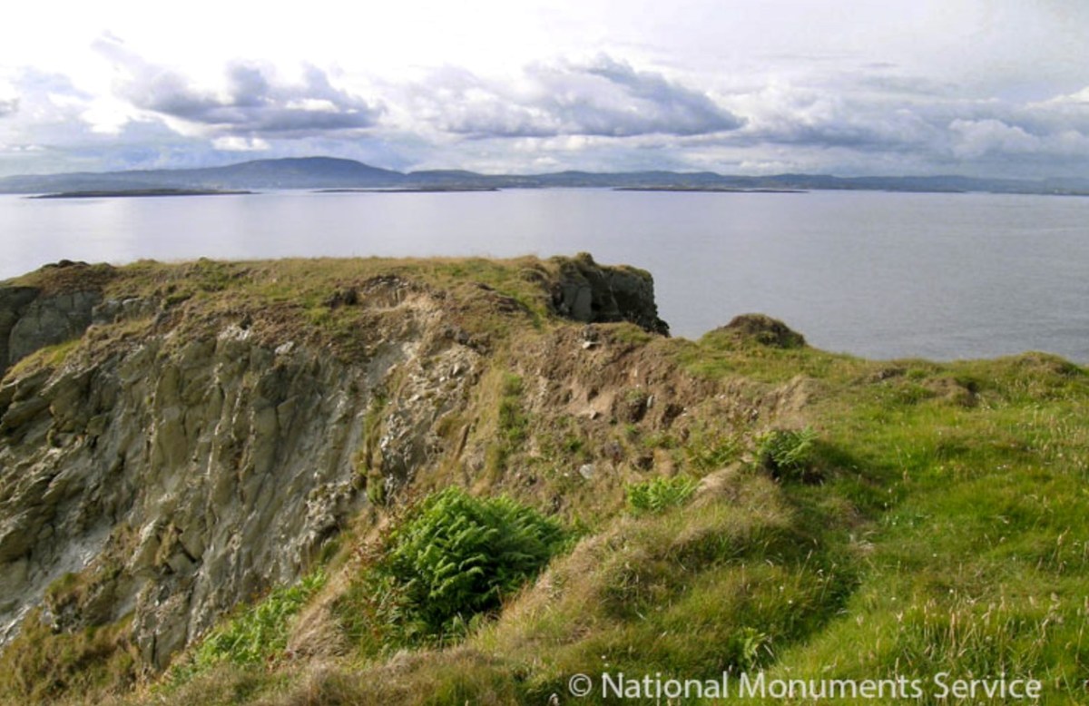
Here’s one of them (below), Lios Ó Móine (the Fort of the Meadow – lios is usually used to designate an earthen ring fort): the description and then the photo are by National Monuments Service (NMS). In the photo you can see the narrow neck of land leading out to the promontory. This is likely what the spit leading out to Dún an Óir may have looked like.
Description: In rough pasture, at the foot of a steep N-facing slope on Stuckaunfoilnabena, a headland on the NW coast of Clear Island. A narrow eroding neck of land (Wth 3m; L 15m) leads to the roughly anvil-shaped headland. Across this neck of land are the remains of three earthen banks and the shallow remains of three fosses. Further examination of the remains was not possible for safety reasons.
Curiously, the NMS does NOT identify Dún an Óir as a promontory fort – here is what it says:
Description: The location of the tower house ‘Doonanore Castle’ (CO153-015002-) on a promontory, on the NW shore of Clear Island, suggested that it may have been built on the site of a promontory fort. However, there are no visible surface traces of an earlier defences across the promontory. The promontory is now isolated at high tide but was connected to mainland by causeway until 1831.
However, it has this to say about the earthwork identified on the high ground:
In pasture, on a steep N-facing slope to the E of the tower house known as Doonanore Castle . . . An earthen bank . . .extends upslope in a S to SW direction from a modern E-W field boundary wall on the cliff-top at N and ends at a large outcropping rock on the edge of another cliff. This bank appears to have formed part of the defences on the land approach to the castle from the E. The bank has three contiguous linear stretches [and] there is an entrance near the N end. There is a possible hut site near the centre of the enclosed area. The short promontory on which Doonanore Castle stands is a possible coastal promontory fort.
So, as you can see, although the NMS declines to label it a promontory fort because there are no longer any signs of banks or walls, it does concede that it is possible. It also extends the defences of that fort to the higher ground above it.
Back to Westropp – He quotes:
the poem of O Huidhrin, before 1418, tells how “0 hEidersceoil assumed possession of the Harbour of Cler.” It was of some importance to the foreign traders in wine and spices, and so figures in all the early portolan maps. Angelino Dulcert, in 1339, calls it Cap de Clar ; the subsequent portolans, Cauo de Clara, 1375 and 1426 ; Clarros, 1436 ; C. d’Clara or Claro, 1450 and 1552, and, to give no more, Cauo de Chlaram, in 1490. The 0 Driscolls’ Castle probably dates between 1450 and the last date. It was probably on an earlier headland fort, as it is called Dunanore. In 1602 it surrendered without resistance to the English, who burned it.
Westropp goes on to say
Dr. O’Donovan, in his ” Sketches of Carbery,” gives a few notes on the later history. He says there was a garrison at the Castle in Queen Anne’s time, and mentions the huge iron ring-bolt, set in the rock, to which the O Driscolls formerly moored their galleys in the creek. The last is improbable, even to impossibility: no one could moor galleys in the dangerous wave-trap, open to the most stormy and unsheltered points. The islanders regard the ruin as haunted, and tell of the singing of ships’ crews in its vaults. One “Croohoor” (Conor) O’Careavaun (Heremon’s grandson) lived as a hermit there in the eighteenth century. Another legend tells how, in 1798, the inhabitants painted the Farbreag Rocks and pillars so as to resemble soldiers in uniform to keep away the French ! If any truth underlies this, it is probably based on the idle act of some revenue or other officers, in the endless leisure of their island station.
In the map above, of the southwest end of the Island, you can just make out the name Firbreaga, almost covered by the O of OSI. Fir Bréaga means The Lying Men, an apt translation given Westropp’s story. No doubt the name is older than 1798, and may refer to the cliffs at that end seeming to be less dangerous from the sea than they actually were. Note also the two yellow dots for two more promontory forts- Doonthomas (Thomas’s Fort) and Coosfoilaskehaun (the Small Harbour of the Knife-Edge Cliff).
Westropp’s description of the promontory upon which Dun an Óir sits is poetic:
The path runs up a very slight ledge, flaking away and high above the creek, along the face of a cliff of polished silvery slate. The low neck joined it to the mainland, and the nearly perpendicular strata make the dock-like creek of Coosadoona, fort-cove, to the south Beside this cove, opposite to the castle, an enormous precipice rises high above the tower top. In the other direction is a noble view across the wide, porpoise-haunted bay, and its low islands to the blue, many-channelled Mount Gabriel, and on to Mizen Head.
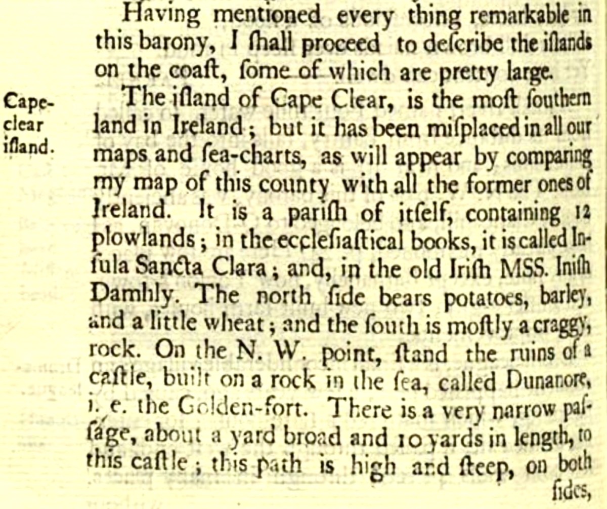
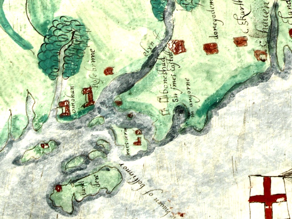
In fact, very little is known about the history of Dún an Óir before the Battle of Kinsale in 1601. We can deduce from its strategic location that the O’Driscolls used it to keep an eye on every ship that sailed in and out of Roaringwater Bay, to exact fishing dues before the rival O’Mahonys could get to the incoming vessels, to curb the power of those O’Mahonys, and to establish their dominance over the land of Cape Clear Island. (See this post for more on the map above.) Because the castle would have been rendered, probably in some shade of white or near-white, it would have been visible from all around Roaringwater Bay, and have represented a potent statement of supremacy.
After the Battle of Kinsale the Castle was seized by Captain Harvey, as described in Pacata Hibernia:
‘While these things were on doing, Captain Roger Harvy sent a party of men to Cape Clear,the castle whereof being guarded by Captain Tirrell’s men, which they could not gain, butthey pillaged the island and brought thence three boats; and the second day following therebels not liking the neighbourhood of the English, quitted the castle, wherein Captain Harvy placed a guard. At this time Sir Finnin O’Driscoll came to Captain Harvy and submitted himself.’
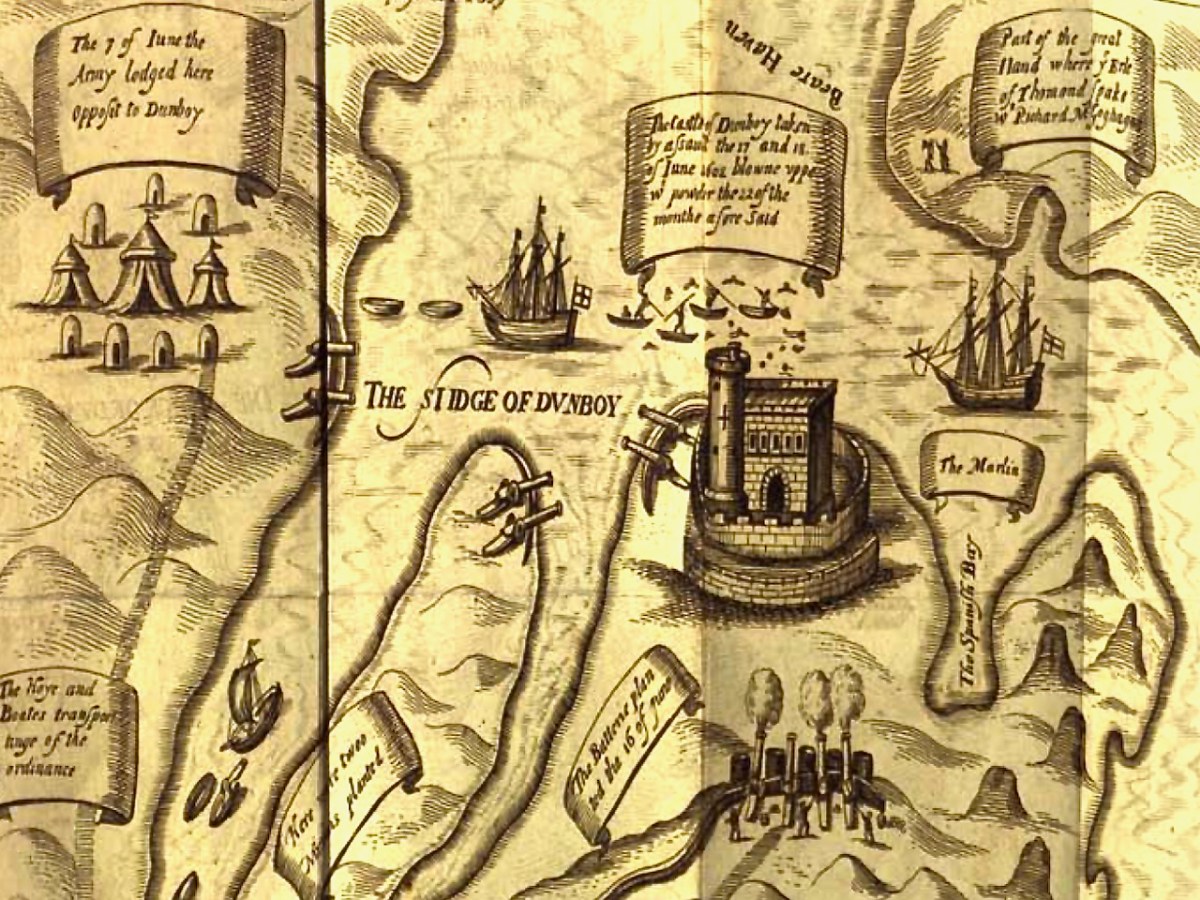
This illustration, from Pacata Hibernia, is of the siege of Dunboy Castle, the stronghold of O’Sullivan Beare, on Beara Peninsula. The destruction of Dún an Óir is described by James Burke in his article Cape Clear Island in the Journal of the Cork Historical and Archaeological Society Journal of 1908. Rather than Harvey simply taking over the castle, Burke relates the following:
Its central arch and the steps leading to its upper portion remain; but the huge pieces of its eastern wall now lying about show how severely it has suffered from the havoc of war. This wholesale destruction occurred when Dunanore Castle, together with the island, was captured on the 22nd of March, 1601, by Captain Roger Harvey, following on the defeat of the Spaniards at Kinsale. By means of the artillery he planted on the high ground adjoining it, he battered down the eastern wall and compelled the garrison to surrender, for which and other services (as Dr Donovan writes in his “Sketches of Carbery”) he was granted at the time a commission by Lord Deputy Mountjoy as Governor of Carbery.
It is far more likely that the ruined state of the castle is a result of the natural passage of time than the ‘havoc of war.’ For one thing, it would have been a monumental task to deploy artillery overland on Cape Clear. Any cannon fire would have come more naturally from the English warships we know were in use during this period and therefore, the damage would have been to the seaward side of the castle – but this side is actually intact.
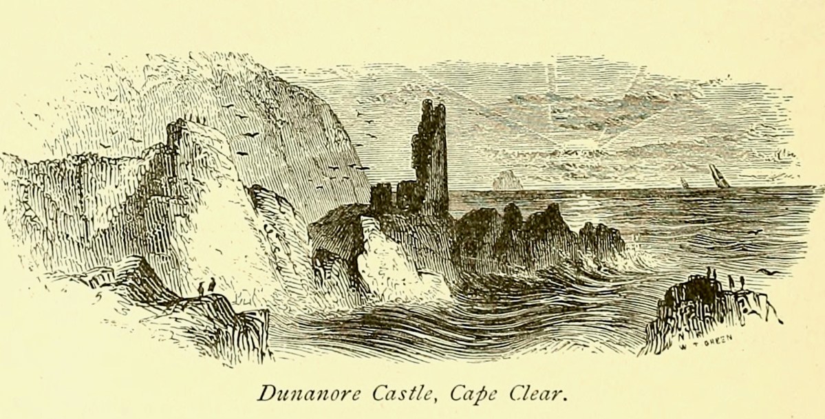
A romantic view of the ruins of Dún an Óir above, by W Willes.* Next week we will look at what is left of the castle and what we can tell from that. I’ll be using the marvellous photos from Tash in that post.
Last week we gave a brief introduction to the wealth of historical material that we can find in the website devoted to the 17th century Down Survey – here’s a link to that site, and another (here) to our previous article. The subject – and some of the deeper detail we can discover in the website – is well worth a further look.
The Down Survey (the above view of some of the islands out in Roaringwater Bay is extracted from it) was carried out between 1656 and 1658, and thus gives us an excellent picture of how terrain we are so personally familiar with was perceived pictorially in the mid 17th century. We don’t know who the surveyors were, except that they were under the command of Sir William Petty, ‘surgeon- general of the English army’. Ireland became one of the most-mapped countries in the world at that time, following the Cromwellian and Williamite land redistributions. The beneficiaries were the new landlords of the Ascendancy, who wanted to know exactly what they had acquired, and the initial emphasis was on boundaries and basic land-measurement.
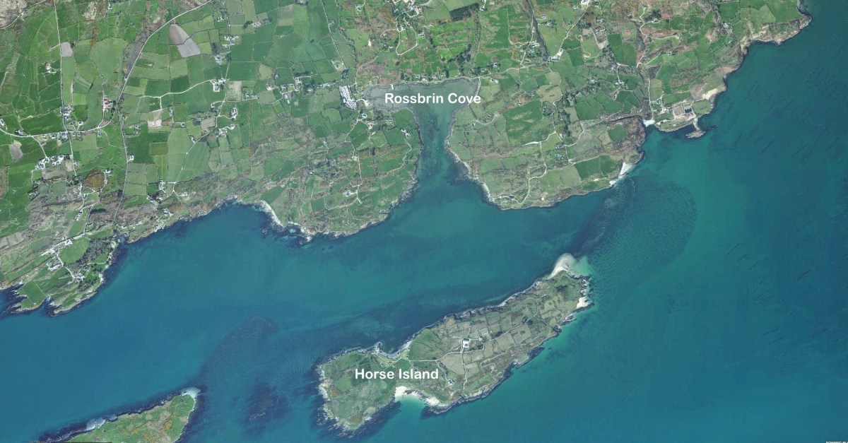
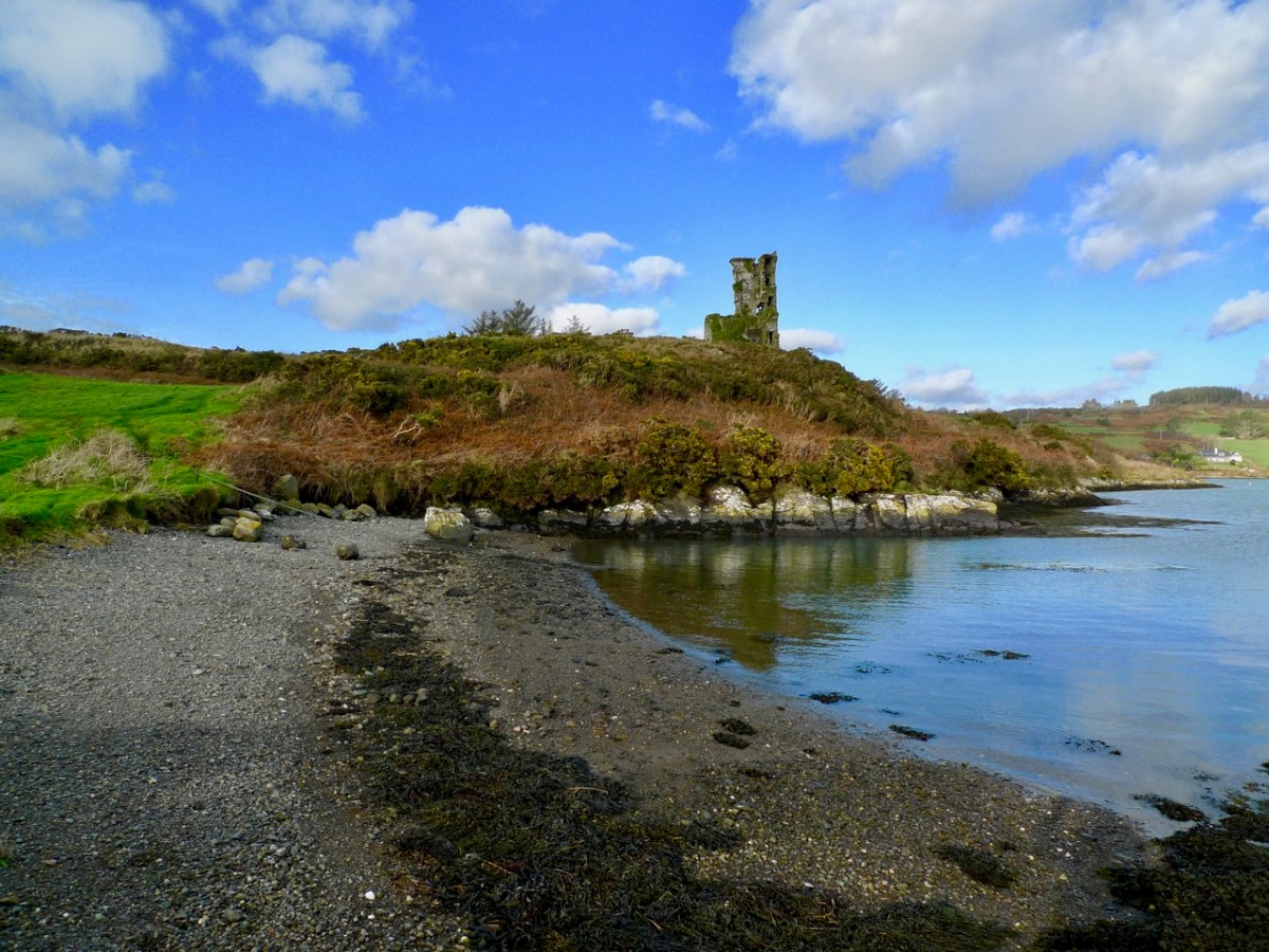
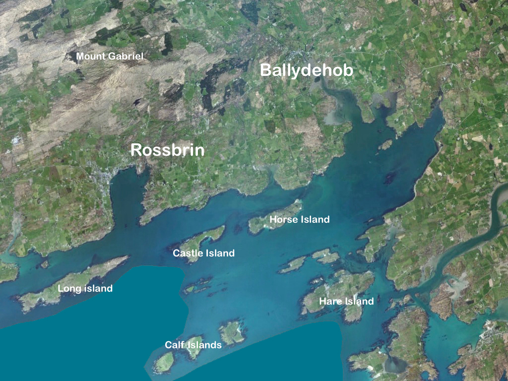
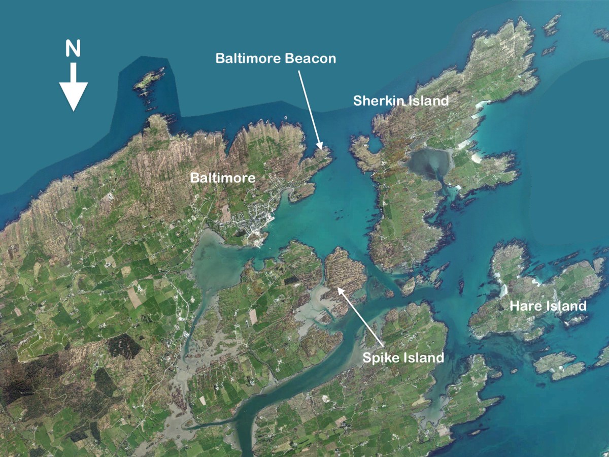
We wanted to know what our little bit of West Cork looked like on those earliest maps. Our view is down toward Rossbrin Cove, below where we live, and our house is a mere blip on the contemporary aerial view at the top of the page. In the first example from the Down Survey mapping – under that view – the cove of ‘Rofsbrinine Harbour’ is marked, and the castle, whose remains still guard the harbour entrance to this day (above), is clearly shown.
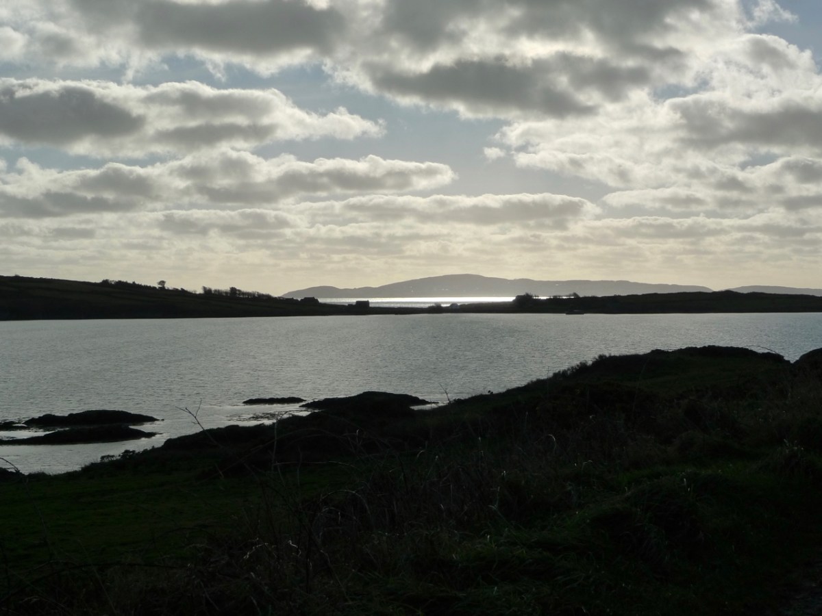
This view looks across the channel from the site of Rossbrin Castle. Immediately in the foreground is Horse Island, while beyond is the distinctive profile of Cape Clear. Let’s look at the Down Survey entry for Cape Clear – with. for comparison – a modern map of that island below it.
That map, above, is taken from a nautical chart. It’s understandable that a 17th century map wouldn’t have the level of accuracy we would expect from a modern survey, but take a look, now, at this contemporary aerial view of Cape Clear Island:
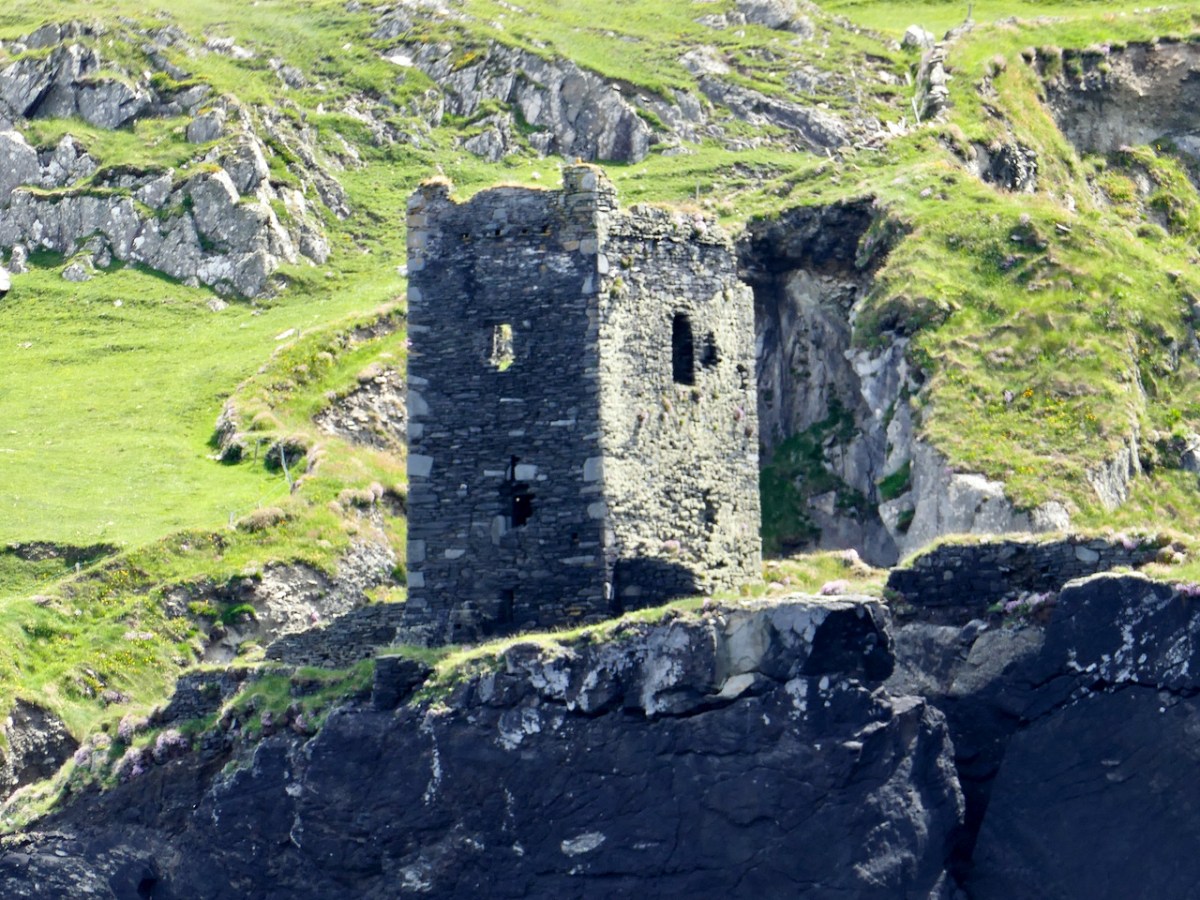
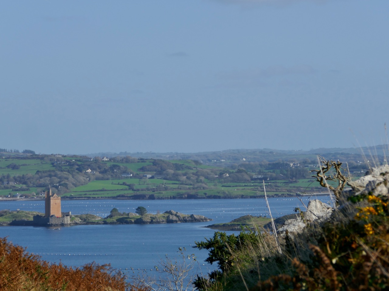
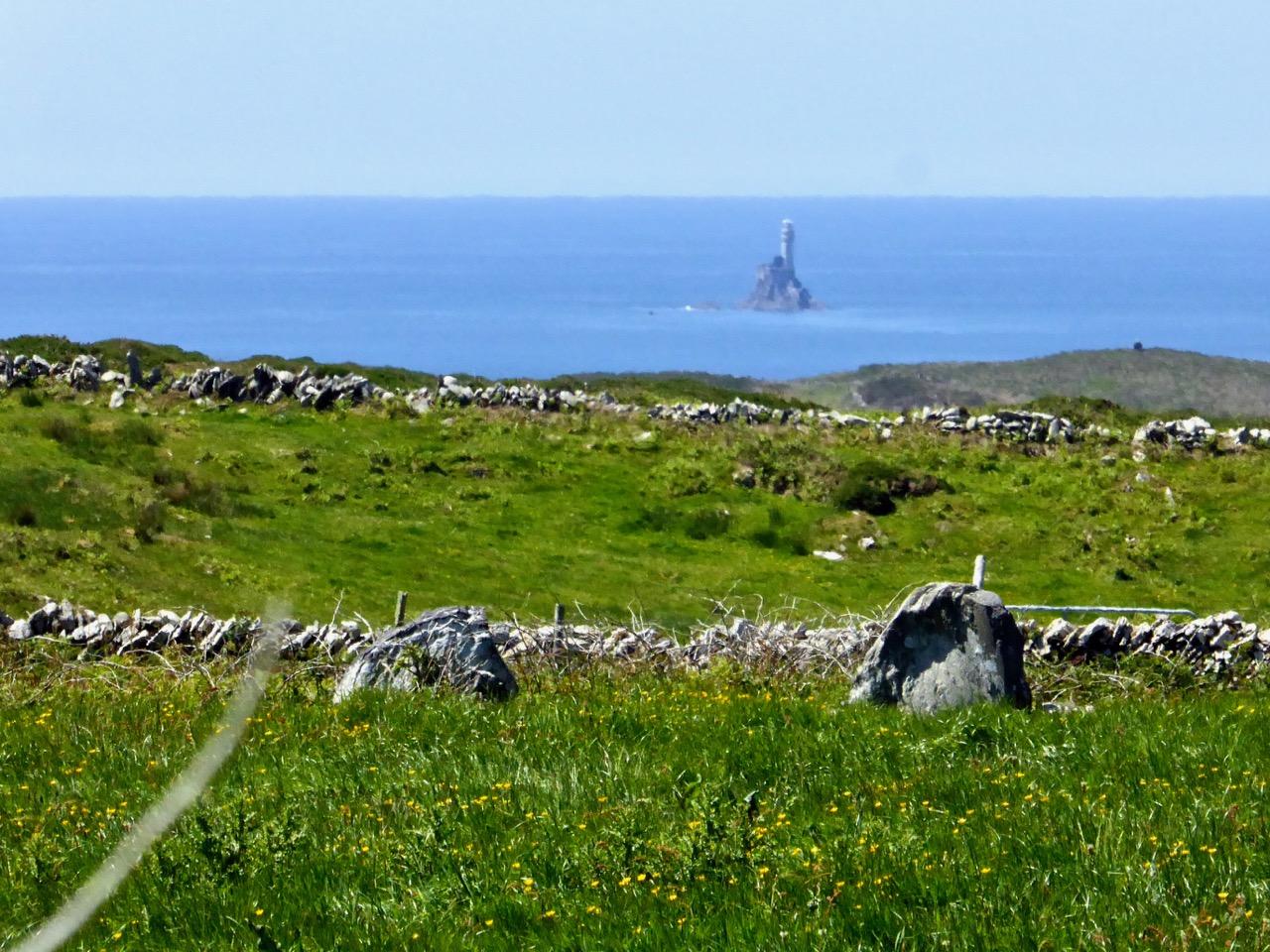
It’s remarkable, I think, how strikingly the early map resembles the profile – if not the fine detail – of the modern chart – and also the shape of the island as shown on the aerial view. For example, the ‘Bill of Cape Clear’ shows up very clearly on the chart – the beak-like protrusion on the far western end of the land-mass – a feature which is represented as very similar on the 17th century version, and of course on the modern prospect. Here’s a view of Dún an Óir – Cape Clear’s castle – today:
Just to add to the experience, the above satellite view gives a more ‘flattened’ impression of what is really going on locally: compare this to the expanded view of our coastline from the Down Survey – note that ‘Cape Cleare’ is included on this extract:
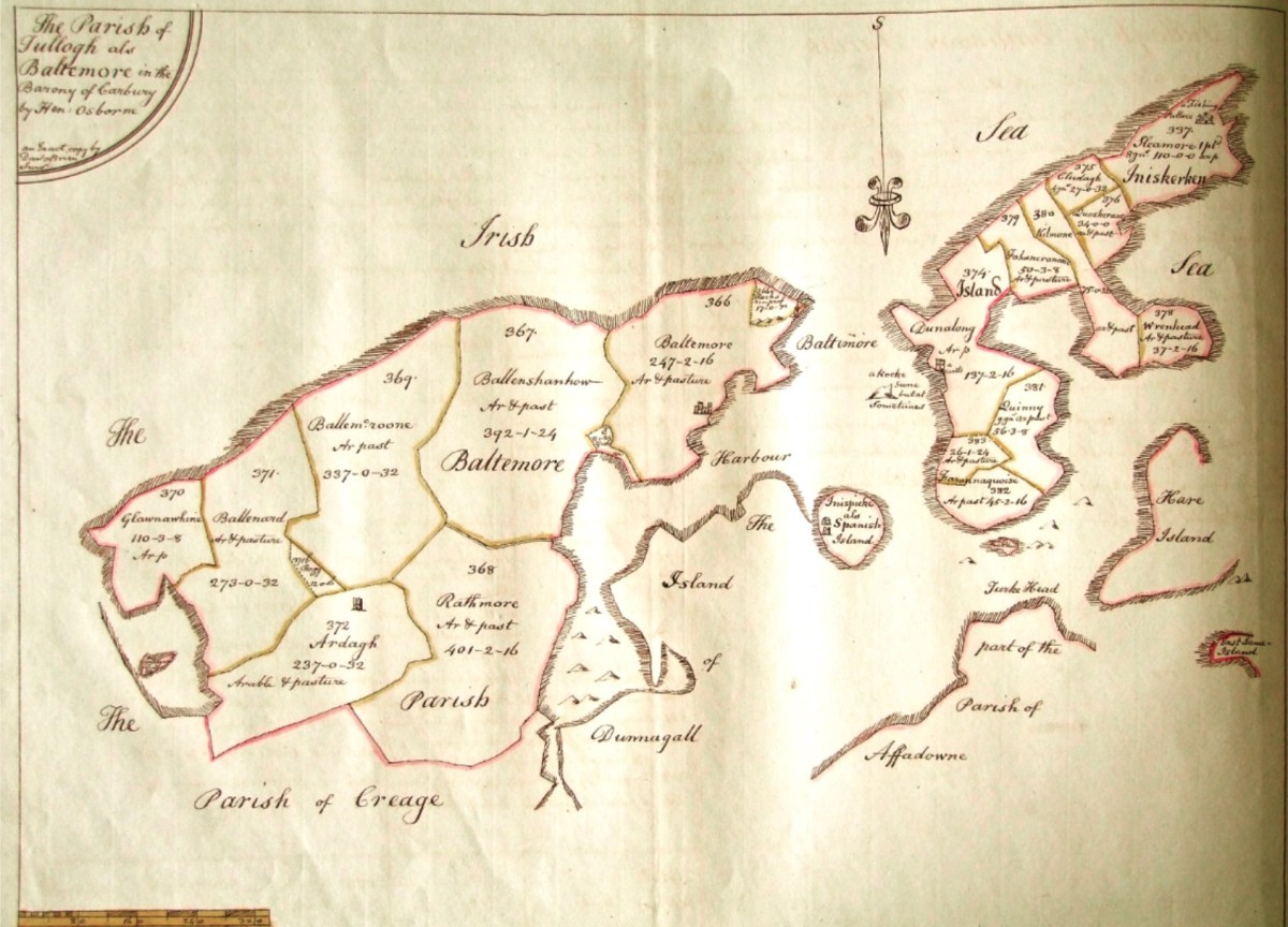
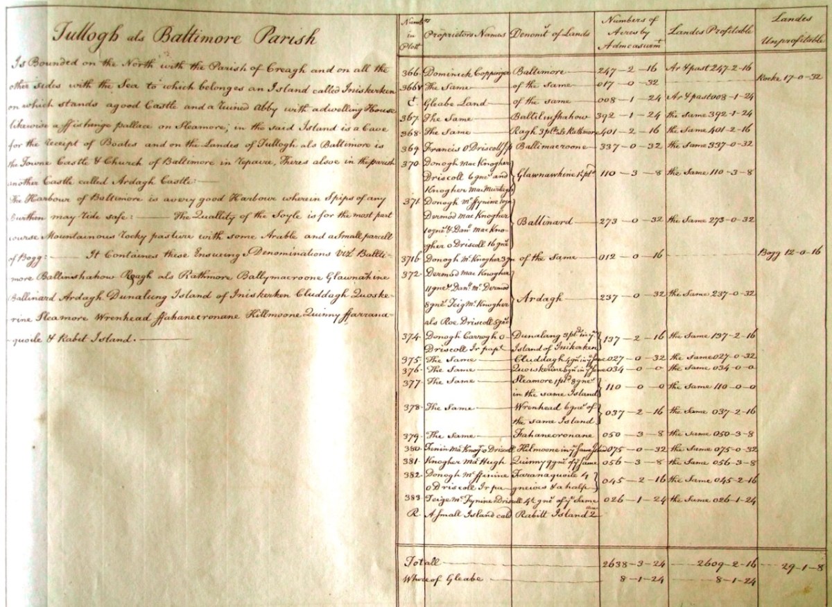
As a further example, to finish off this brief overview (which will be continued in future posts) let’s have a look at the Down Survey entry for the Baltimore area – a little further along our coast, travelling east:
This is in fact the Down Survey entry for the Parishes of ‘Tullogh & Baltimore’. The first thing to note is that the north point is facing downwards! If you look at many of the survey pages the orientation varies considerably, and is probably more to do with what conveniently fits on a sheet than any attempt to be consistent. So that we can make an easier comparison with today’s terrain, I have also switched the orientation of this aerial view:
In my opinion it’s remarkable that the Down Survey maps do bear a very reasonable resemblance to the reality. Obviously, a great deal of detail is missing, but the purpose of the maps – to delineate land ownership – is satisfactorily served (albeit that this is to the benefit of the incoming English lords and landowners).
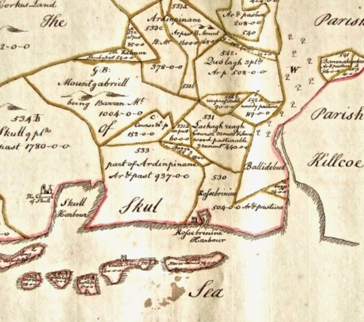
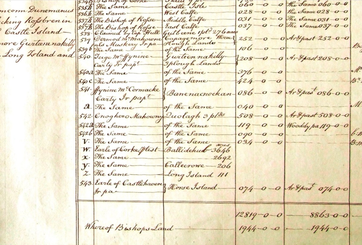
Here’s a view of the site of the medieval fish palace at Baltimore. The Down Survey comprises more than maps: there is other related material, including terriers. These particular terriers don’t have legs or tails – it’s a term for a written, descriptive survey of an estate: some english examples are recorded from the ninth century. Here’s the terrier for Baltimore within the Down Survey:
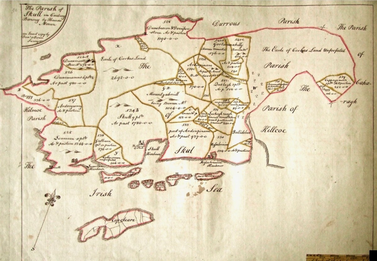
The terrier in this case is mainly a description of parcels of land, their owners, and the values. Here’s a closer example, from a terrier for ‘Skull’:
There’s a lot more of West Cork within the Down Survey archives. A future post will turn in greater detail to some of this material.
Note of explanation from Finola and Robert:the Blog has taken on a mind of its own and decided he needs to make some resolutions for 2019.He has asked us, his slaves faithful staff, to record these, as a means of keeping him accountable. Ours not to question why, ours but to do or die, so here goes, in his own words. . .
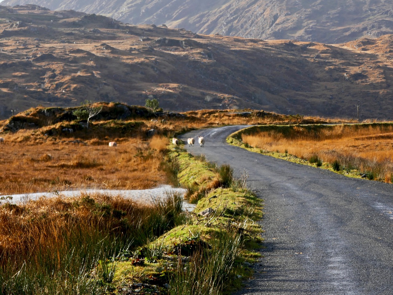
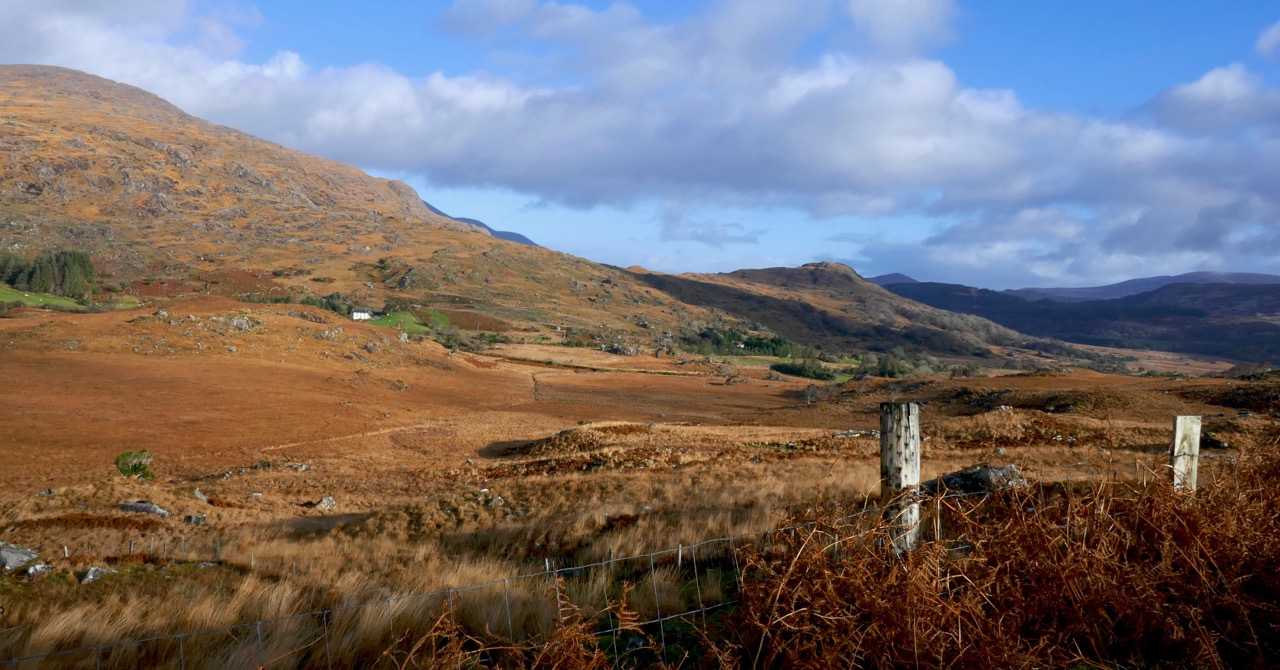
The Black Valley, Kerry
1. Spend more time in Kerry
It’s only next door, after all, and it’s in Finola’s blood, since her grandmother came from Killarney and she still has lots of lovely family there. So I’m determined they will take me there on outings a bit more often this year. There’s an ulterior motive too – you, my faithful readers, know that I often cosy up to that cheerful little Bloguette Holy Wells of Cork: she’s running out of wells in Cork but is enthusiastic about the idea that we can go jaunting off together on Kerry adventures.
2. Incorporate more music
I have to let you in on a secret – Robert is forever promising to learn new tunes for me, but then he comes up with all kinds of excuses why he’s not getting on with it. He’s too busy, it’s too hard, it’s not in the right key, blah, blah, blah. He’s finally sort-of learned this one, after weeks. We live in the heart of Irish traditional music – come on, people!
Staff member Robert trying to get it right – it’s called Pearl O’Shaughnessy’s Barn Dance, learned from Clare concertina player Mary MacNamara
3. Get on with that Saints and Soupers story
Honestly, that Finola, she leads us deep into this fascinating study of whether or not that Fisher guy was a saint or a souper, and then she goes off on one of her tangents about stained glass or wildflowers or whatever. I’m dying to know what happens next, so I’m going to have to lean on her to put the nose to the grindstone and get back to all those Protestants and Catholics and the actual famine part.
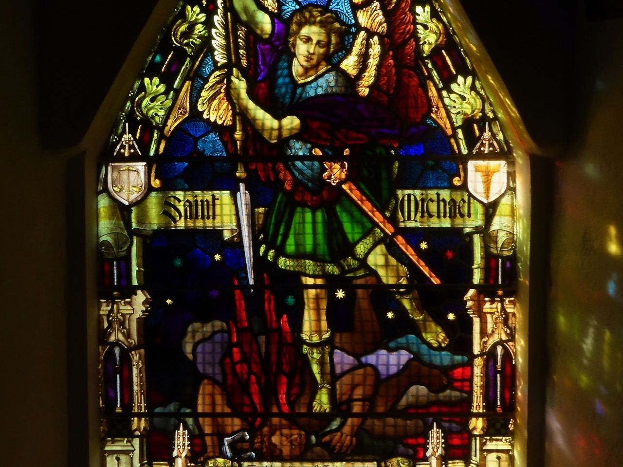
Michael the Archangel fights the devil – a powerful good versus evil metaphor in Altar Church
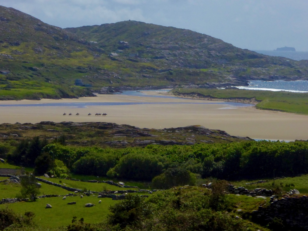
4. Get out to the Islands
It’s called Carberry’s Hundred Isles, for goodness sake – we can see them from the house (like Sarah Palin and Russia). Time totravel to more of them and get to know them.
South Harbour on Cape Clear
I’ve been polishing up my Irish (or Blirish, as we Blogs like to say) and I need the practice, so Cape Clear needs to be on the agenda. I hear they have a good Blirish program out there, so ar aghaigh linn!
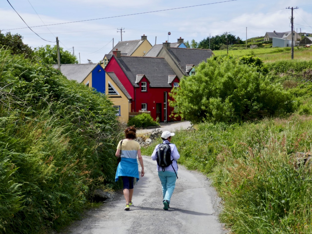
Staff member Finola and her sister on Cape Clear this summer
5. Finish the Fastnet Trail walks
This is a bit of a hangover resolution from previous years when I vowed to do all the Fastnet trails, but got a bit distracted with other walks and other projects. Besides, they’re adding to them all the time so if I don’t get off my desk and get out there soon the job will just get bigger and bigger.
Kilcoe Castle can be seen from several of the Fastnet Trails
6. Find more places to have breakfast
My staff loves going out for breakfast and I must say I am very partial to a nice plate of avocado toast and smoked salmon, with a good pot of tea to wash it down (although those two insist on lattés). They took me to the Box of Frogs in Bantry recently, and despite my misgivings about the name (I had a bad experience with a toad once) I had to admit the food was excellent. But, like all the humans I meet recently, I’ve been toying with the idea of eating less meat so I will persuade them to go to Antiquity Bookshop Café in Skibbereen for their tasty vegan food more often. BUT. . . see next resolution
Nicola surrounded by her stock in trade in Antiquity, West Cork’s first vegan café
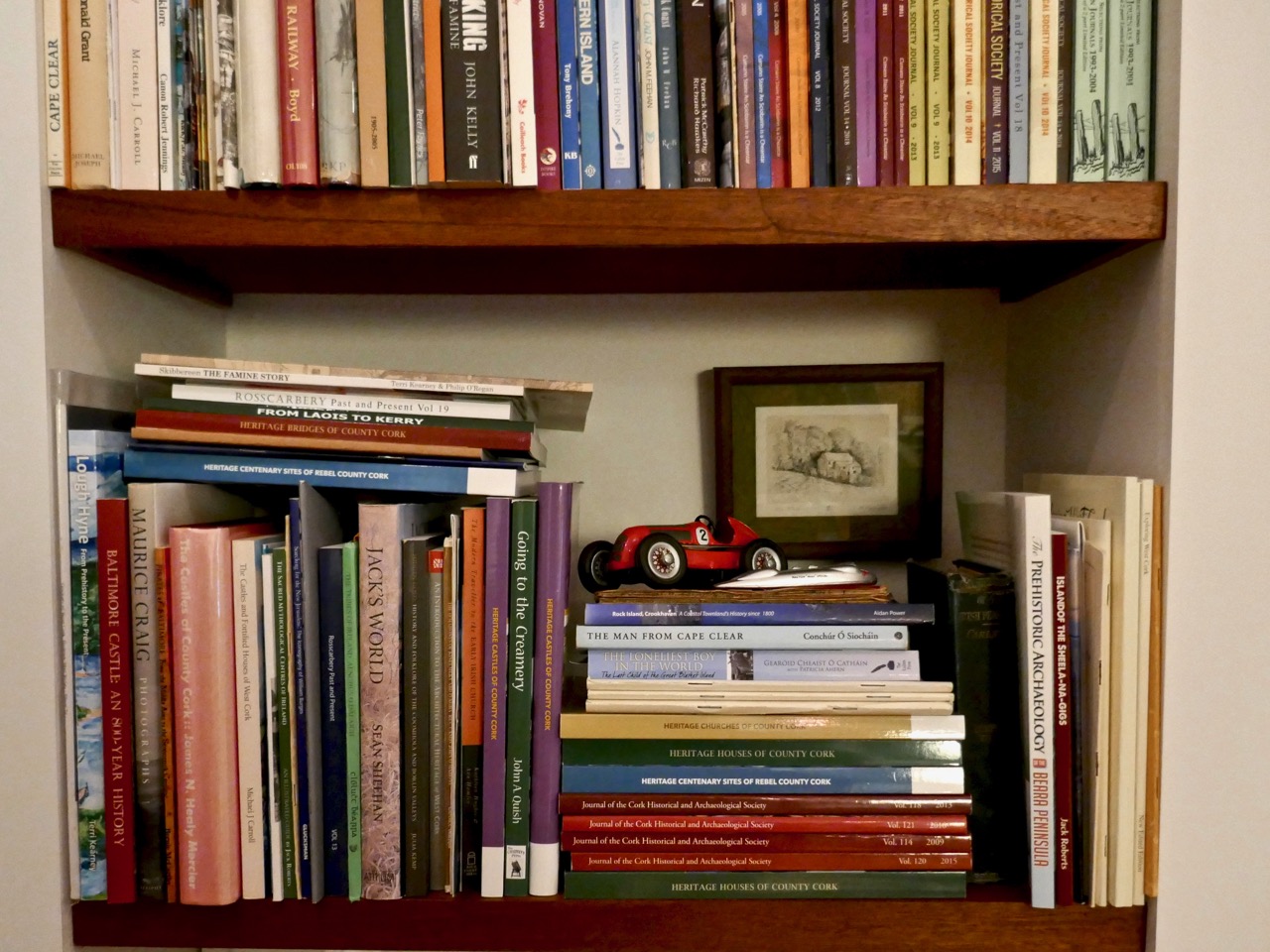
7. Read the books!
The staff keep bringing more books (especially from Antiquity) into the house and they pile up beside me, making me feel guilty that I’m not keeping up. They built a new set of shelves and they are already filled. Honestly, in this day and age, you’d think someone would have invented some kind of scanner-to-brain technology so that Blogs like me wouldn’t have to work so hard.
Just one shelf – yikes!
I have more, but the experts say not to make too many. Right, friends – a little encouragement and I’m sure I will be fine, despite all the malingering and complaining of my staff. Onwards and upwards into 2019!
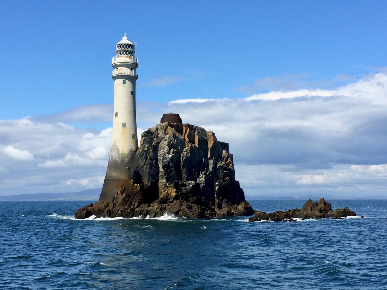
Way back in 2014 I wrote about An Carraig Aonair: The Fastnet Rock and I have decided to repost that today, but with some updated information and photographs, because of an upcoming change announced by Irish Lights. Depending on the story, this is either a relatively benign but majorly cost-saving switch to LED lighting, or a change we must be vigilant about to make sure the Fastnet is left “intact and unharmed”.
Irish Lights tells us that structural repairs. . .are necessary to ensure the metal lantern room is properly secured to the granite tower and modernisation of the light source to an energy efficient rotating LED lantern. When these works are completed the outward appearance of Fastnet will be unchanged. The work will improve our environmental impact by significantly reducing the need for diesel and generators and by removing all mercury from the station. The range of the light will reduce from 27 to 18 Nautical miles.”
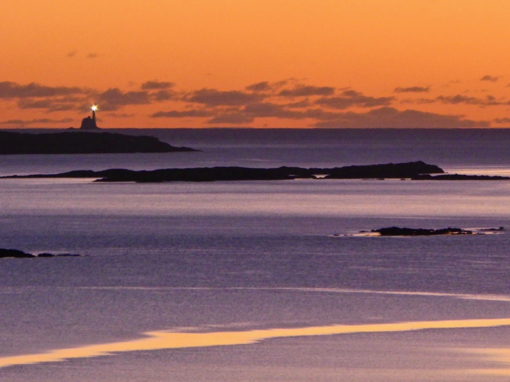
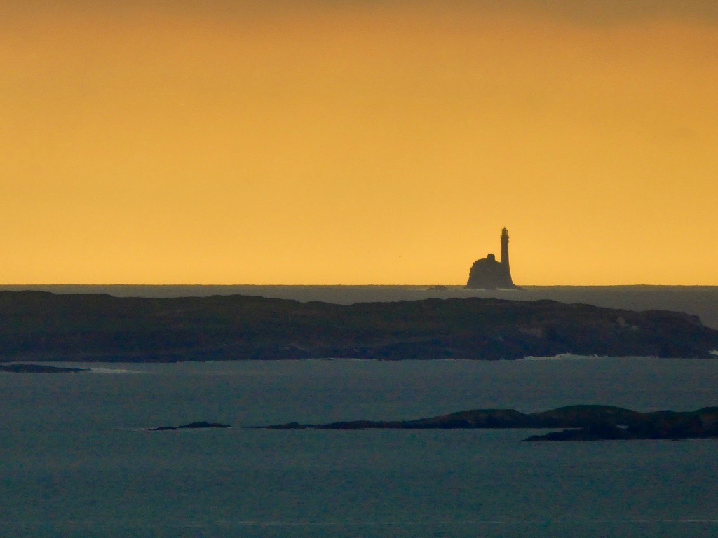
This photo was taken from our house, 12 miles (or 10.4 nautical miles) away
While this seems like a sensible and inevitable modernisation, with (according to this letter to the Irish Times) a very significant saving of €100,000 per year, those of us who live around Roaringwater Bay want more information: we want to be sure that the change does not negatively impact on the safety of our sailors and fisherfolk, and does not rob us of the iconic flash that is so much part of our lived experience in West Cork. There will be a meeting on Monday (March 5, 2018) at the Schull Sailing Club to discuss it all.
What follows now is the text of my post from June of 2014, lightly edited and with some newer photographs inserted.
Robert has written about our field trip to Cape Clear Island and I can now reveal that the journey also included a thrilling sail around An Charraig Aonair (Karrig Ane-er, The Lone Rock) better known as the Fastnet Rock; or to thousands of emigrants for whom it was the last sight of their home country, Ireland’s Teardrop.
We had been looking forward with great anticipation to visiting the rock close up. We can see it from our home, a far away mystical crag abounding with lore and legend. We have been awestruck by the waves crashing over the lighthouse in winter storms and wondered at the lives of the lightkeepers who once manned that treacherous outpost. We watched through our telescope as enormous yachts rounded the rock in the biennial Fastnet Race last summer, following the progress of the race on a special iPhone app. I have written elsewhere about the awful tragedy of the 1979 race, in which Gerard Butler and his fellow lightkeepers on the Fastnet played a crucial role in monitoring the participating yachts in the mountainous sea conditions.
The signal station and the first lighthouse, on Cape Clear Island
The Fastnet was built to avoid such tragedies. Its first iteration was in 1818 as a lighthouse tower on a high point on nearby Cape Clear Island, beside the Napoleonic-era signal tower. However, the light was frequently obscured by fog and after the wreck of the Stephen Whitney in 1847 with 92 souls lost, it became clear that the best place for a lighthouse was on the Fastnet Rock.
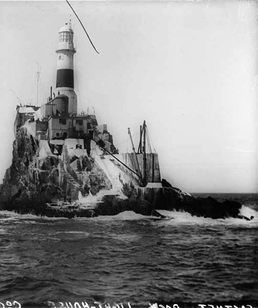
The great era of lighthouse building in Ireland got underway in the mid-nineteenth century. The engineering, design and construction expertise necessary to build lighthouses are impressive enough. Add to this the logistics of building on a tiny and inhospitable rock in a heaving sea on the edge of the Atlantic, and the sheer accomplishment of the objective is staggering. The first attempt, started in 1849, was of steel and needed constant repair.
The first lighthouse on the rock – it was made of steel and didn’t last
It was decided to replace it with a structure of Cornish granite and the current lighthouse first cast its beam over the waters in 1904. Eamon Lankford in his book Fastnet Rock: An Charraig Aonair describes the building process and provides old photographs illustrating how the granite blocks were ‘floated’ and hoisted on to the islet, having been first assembled and tested in Cornwall. The website Digital Irish Lighthouse Experience by Sandra Michler has an animated sequence showing how this was accomplished. it took eight years.
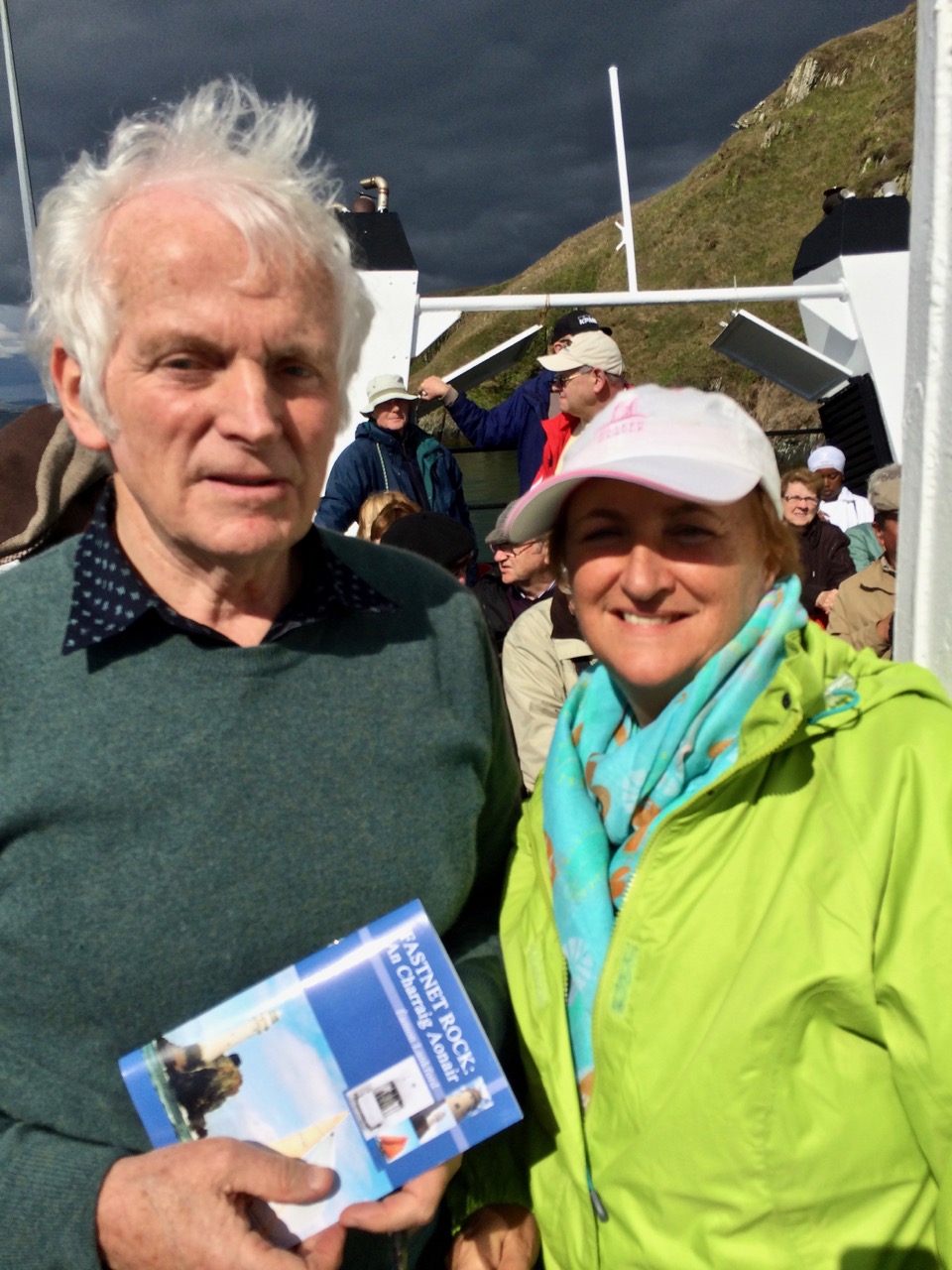
We were fortunate to have Eamon Lankford as one of our guides on our trip to the Fastnet
One of the best accounts of the building of the lighthouse was in a 2008 article in The Economist called Light on a Lonely Rock. The piece gives fascinating details into the dedications and hardships of the builders and calls the lighthouse “a monument of man’s gift to mankind.” I don’t know who wrote it, but it’s a terrific essay.
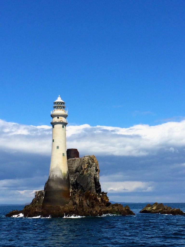
According to the Irish Lights website, Fastnet is the tallest and widest rock lighthouse tower in Ireland and Great Britain and was a monumental achievement when completed in 1904. Each of the granite stones of the tower is dovetailed into those around it, bonding the structure into a virtual monolith. This webpage also has several excellent photographs of the lighthouse from the air. What all photographs of the rock also reveal is that the lighthouse is a thing of beauty. Tall, slender and elegant and boasting two balconies, it personifies form and function in the most admirable fashion possible. (Take a look, for example, at Dennis Horgan’s website – he’s an acclaimed aerial photographer and his photograph of the lighthouse is probably the most iconic shot of them all.) Today the Fastnet is fully automated but in The Lightkeeper Gerard Butler describes what it was like to live on the rock in fair weather, when he fished and swam from the steps, and foul, when the seas crashed and roared over the lighthouse as it quivered and shook all night.
The lighthouse showing the full extent of the Cornish granite and the stub of the old steel tower
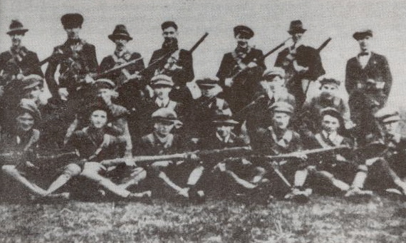
One of the stories we heard from Eamon concerned a daring midnight raid on the lighthouse carried out by an IRA ‘Flying Column’ (experts in guerilla warfare) in 1921 during the Irish War of Independence. They were after the explosives used on the Fastnet to power the foghorn. [EDIT: I have some errors here – please see Finbarr O’Driscoll’s correct information about the raiding party in the comments section.] In researching this story further, I found an article in the 1999 Mizen Journal (no longer in print) by Frank Lannin, based on the eyewitness statement of Sean O’Driscoll.*
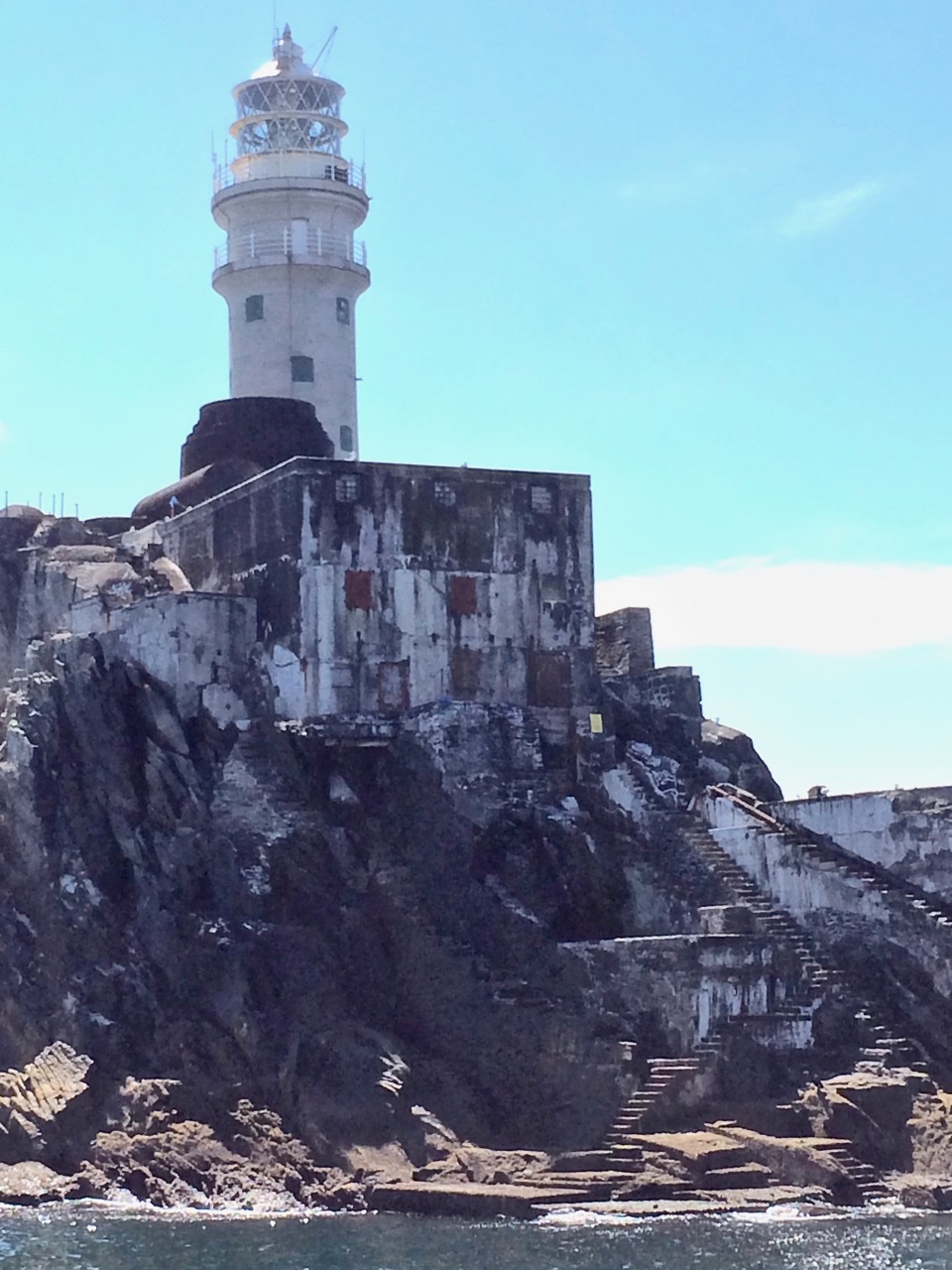
The Rock, showing the landing platform, steps and store
Here is part of Lannin’s account:
The breeze had freshened and caused the usual swell around the Rock and there was a rise and fall of several feet. The anchor was let out and the boat moved slowly to the landing place. Positioned on the bow was John O’Regan, a rope tied around his waist, a revolver in his pocket and balancing himself with the rise and fall of the boat. He would have to select the right moment to jump on the Rock and catch the iron ring which was fixed to the Rock. He knew where the ring was fixed, but to grasp it in total darkness was a feat that few would attempt. His vast experience as a seaman was now to be put to the test. As a wave was rising he jumped. It was a tense moment. As the wave covered him he grasped the ring with both hands. (It was an occasion for handclapping, but not tonight.) In seconds he had made the boat fast and the rest of the raiding party were landing on the platform. The huge steel door of the lighthouse was not locked. John was first up the spiral stairway leading to the room where the Lightkeeper was on duty. He put up no resistance and as a precaution the wireless was dismantled. Seventeen boxes of gun cotton and three boxes of detonators and primers were loaded on to the “Maire Cait” by means of the lighthouse derrick. in all, the spoils weighed but one ton. The daring mission was accomplished.
A Flying Column (this one from Tipperary)
The fog signal, together with the light, was an important aid to navigation for ocean going vessels. It was only in 2011 that the Fastnet foghorn was permanently discontinued, as modern navigation equipment rendered it unnecessary. All around the world people are missing the haunting sound of foghorns now, a sound so many of us grew up with. But at least we can see the light from Carraig Aonair every night and count its ‘character’ – one two three four FLASH…one two three four FLASH – and know that it’s doing its part to keep our mariners safe on the seas that roll outside Roaringwater Bay.
*See pages 18 to 20 of Sean O’Driscoll’s statement for his dramatic story of the raid.
Welcome to the UCD Library Cultural Heritage Collections blog. Discover and explore the historical treasures housed within our Archives, Special Collections, National Folklore Collection and Digital Library