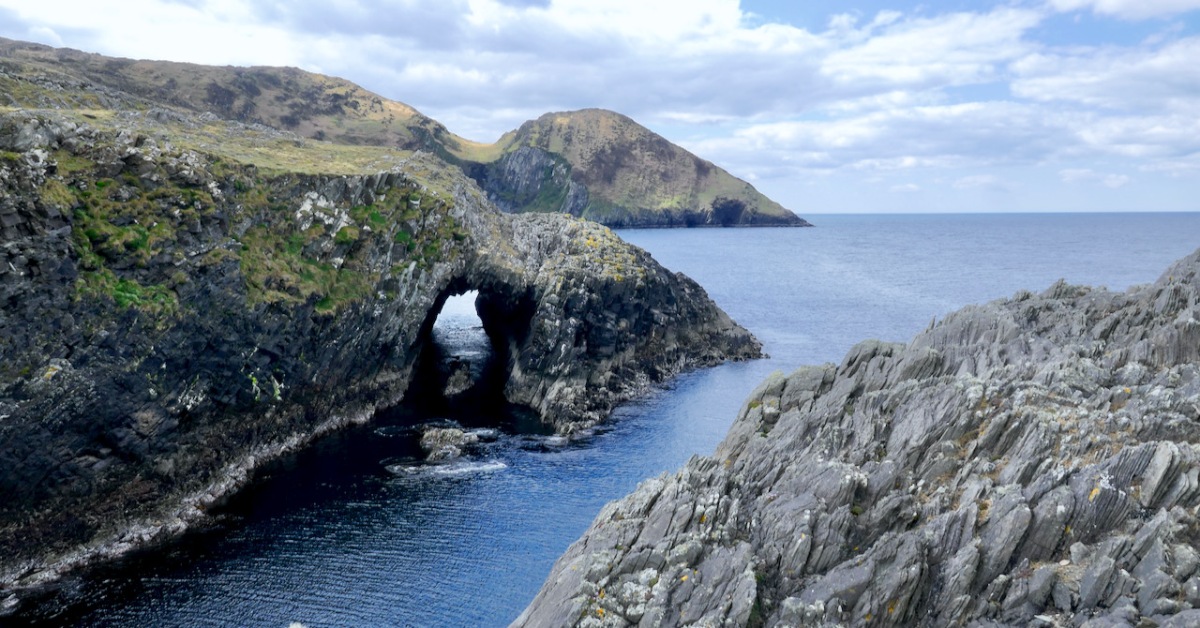
Drawn by the lure of sea-arches, we visited Lackavaun this week. Wild, remote and uninhabited now, but it wasn’t always so.

We’ve written before about Northside of the Mizen by Patrick McCarthy and Richard Hawkes, with illustrations by Thelma Ede. Published in 1999, it’s still available. I am drawing on this book for information about Lackavaun, with gratitude to the authors for all the work that went into this marvellous compendium of Tales, Customs and History.

As you can see from the map, the main feature of Lackavain (leaca bhán – white slabs) is a rugged and bare peninsula. Not very promising, you might think. But see that sheltered spot on the south-eastern end – a grand place for a little quay. It was used for many purposes – fishing, of course, but also for getting to Bird Island. And even though there are no houses on the peninsula now, and none on the historic maps, we came across evidence of cultivation, in the form of potato ridges.

The peninsula we explored, with good friends Con and Una, was traditionally known as the Meallán (pronounced mal – awn, meaning a small knoll). It is also labelled Dooneen (Little Fort) on the historic 25inch map, and the harbour Dooneen Coos. This is rendered as Doonleen on the Historic 6inch map, which looks like it might be a misprint, since there isn’t a sensible translation. Northside doesn’t use either of those names.

The photograph above was taken from Mount Gabriel. The peninsula we are visiting, The Meallán, in the townland of Lackavaun, is the land that projects into the sea at the top right. Can you make out the sea-arch?
The Northside of the Mizen says of this place:
The first settlers may well have been those from the Iron Age who developed the dun (promonotory fort) at Meallán in Lacakavun, the remains of which still exist. The name Dunkelly (Ceallach’s Fortress) may have derived from this fort and was the name for the whole of the Northside area in the past.
Looking out in to the Meallán – the knoll is straight ahead
This is intriguing! The name Dunkelly is nowadays reserved for two townlands to the east of Lackavaun. The Cailleach (a more usual spelling, pronounced a bit like Kye-lock) is of course the Old Woman, the Hag, the wise woman prominent in Irish folklore. This area, in fact the whole of the Mizen, is the ancestral territory of the O’Mahonys. Another family associated with this area is the Canty clan. Robert has written about Canty the Pirate and we did visit his Cove and his Pirate Steps on this occasion.


Finding the pirate steps again after a few years took a bit of searching and wandering around headlands but here they are, in all their slippery treacherous steepness
But Northside of the Mizen has another take on the Cantys:
In the early seventeenth century the Northside was recorded as being Dunkelly (Dunnekilly) and owned by the bardic O’Canty family, who were possibly bards to the O’Mahonys of Dunmanus Castle. The O’Canty’s took part in a rebellion in 1641, when they attacked Crookhaven and as a result their land was confiscated and granted to an Englishman, Sir William Petty.
Northside goes on to enumerate the population of the area – 11 in 1659, 635 in 1841, shrinking again to 291 people after the famine. By 1911 it was down to 169 souls. Very few people live there now – Northside poignantly estimates it at about the same number as three centuries ago – that is, about 11 people. Some of the houses are holiday homes and so the population rises somewhat over the summer.

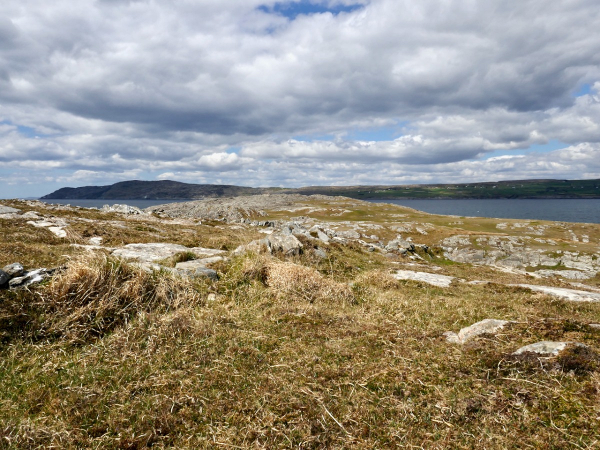
Looking down on Lackavaun from the high ground to the south, it is obvious how depopulated it is now
As we know, potatoes were the staple food of most people before the Famine, and this continued afterwards, when the crops recovered. We came across clear evidence of this on the Meallán, in the form of long disused lazy beds, the traditional method for cultivating potatoes in the West of Ireland. It’s impossible to know how recently these beds might have been abandoned. They could be pre-Famine but are more likely to be more recent than that. None of the historic maps show any dwellings on the Meallán itself, so this was a patch to which people came specifically for this purpose, probably building up the soil over generations with sand and seaweed.

The parallel ridges are the tell-tale sign of former potato ridges, known as lazy beds even though they were labour-intensive
Northside has much to say about the practices, and the vocabulary, of potato growing, beginning in February with the Ridge of Graf.
In the first week of February you would begin on ‘the Ridge of Graf’ lazy bed system using a dry, sunny and sloping ground to give an early crop of potatoes. The ‘Ridge of Graf’ system, although hard work, would give you up to 3 times more crop than setting potato seed in a drill. A good supply of manure was used and you would use stable manure (horse or donkey) as it was said it had a better ‘heat to it’ then yard (cow) manure. The stable manure was spread on to the grass and the seed potato placed on top. This was then covered with the sods, cut with a grafán to open a trench on each side, of 18 – 20 inches. This gave you a ridge of about three feet. Soil from the trench was then put up on the ridge. This was called ‘the first earth’. The last shovel of earth from the trench was put up against the edge of the ridge, and with a good pat from the back of the shovel the grua (side of the ridge) was made.
Each tool had its own name and function. The potato spade was inserted as deep as the bucán, or foot rest. The seed potatoes, or sprouters, were covered in earth using a farraheen to fill in the holes.

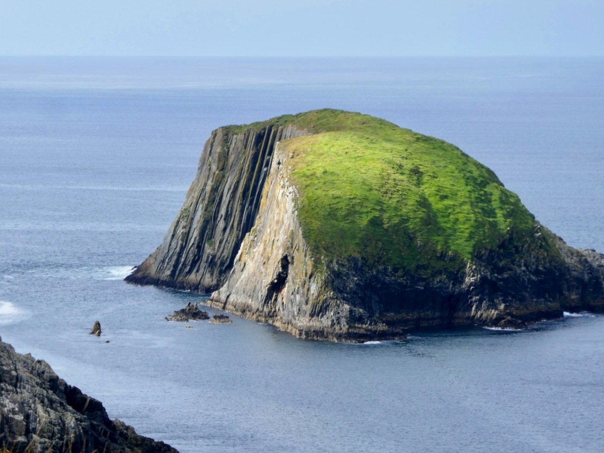
Around this time of year – the start of May – the little quay was put to good use and local boys and men took a trip to Bird Island.

The quay, and an old field wall – impossible to say what period the wall belongs to
This was a tricky island to get on to, there was no landing place and it could only be attempted in calm weather. The first trip was to collect the eggs of the cóbach (the Black-backed Gull). Once ashore, the men attached ropes to iron bars which had been driven into the rock faces, and climbed down the cliffs to gather the eggs.

With the cóbach going mad, it was a tricky job to pull yourself back up with a hand basket and your pockets full of eggs, and often you would end up in a sticky situation!
I get vertigo just looking at the picture – can you imagine collecting eggs from those cliffs?
The second trip to Bird Island was to take sheep there for summer grazing. This happened once the Scairivín na gCuach was over – the ‘cold wind of the cuckoo’ that lasted a week or two (it’s happening as I write this) and was generally seen as the last gasp of winter. That’s Bird Island below, this time seen from the west.

It was a great day for the young and fit lads, and at least three would have to go. Fifteen sheep were taken from Canty’s Cove at Dunkelly or the pigeonholes (Cuasnacolúr) on the south side of Meallán. Getting off at the island was a different matter and you needed a still day, as to get up onto the island, even with a gentle heave, was anything but a joke without a landing place. Once you had a man up, a rope was used to haul up the sheep. In the passing of four months on Bird Island the sheep would be as fat as pigs and as wild as the sea around them. It was the very devil to get them off again. By the time you had a brehóg of sheep in the boat, you would be sweating buckets!


But what about the reason we went there in the first place – those sea-arches? It’s an indescribably eerie feeling to stand on one and see and feel the sea heaving below you.

Your head knows that the chances it will give way under you are minuscule, but it feels dangerous and thrilling nonetheless.

There’s a small sea arch of more recent vintage on the east end of The Meallán, near the lazy beds – you can see the land has collapsed relatively recently. And yet a third on the mainland just west of the Meallán – equally as spectacular as the one we crossed over (above, and the lead photograph). From all points there are amazing views up and down Dunmanus Bay and across to the Sheeps Head.

But perhaps the most special sight of all was Con’s discovery of a nest with three eggs. Una had spotted what we thought were curlews – they had flown up right in front of her as she rounded a ridge, and we reckoned there were six of them. They’re well disguised in the picture below. But – read on. . .

Ireland has lost over 80% of our curlew population since the 1970s and it felt apt, somehow, on this wild and uninhabited corner of the Mizen that they were trying to hang on. Una reported the sighting, but the expert opinion turned out to be that what we saw was actually the nest of an oystercatcher or whimbrel – much more common and not endangered at all. The ‘curlews’ in the photo above are also more likely to be whimbrels – curlews don’t flock in May but the similar whimbrels do. Disappointing!
The Meallán can’t be more than a few acres – but what a place!

Thank you very much, I learn so much from your website and appreciate your hard work and knowledge. I hope to return to West Cork someday and see these places for myself. Thank you, Barbara
LikeLiked by 1 person
Hello Finola and Robert,
I hope you are both well.
How amazing to find a Curlew nest on The Mizen! Dave was involved with the Curlew project for a few years, trying to find nests in Co Kerry. As far as they knew there may have been one pair nesting in north Cork, so finding one on The Mizen is wonderful. Hopefully the adults will successfully rear the chicks. That’s just made my day hearing about your discovery.
Stay well,
Anne
LikeLike
Yes – we were thrilled. Úna reported it to birdwatch ireland but has had no response yet. All fingers crossed that they succeed.
LikeLike
Have now heard back, Anne – and it’s an oystercatcher nest! Too bad.
LikeLike
Thank you Barbara for a lovely lift to a ( very ) chilly windy day here in Dorset, and so glad to see those curlews, they have such an evocative call. This is my Nana’s country – an O Mahoney from up Durrus way.
LikeLiked by 1 person
Absolutely brilliant to hear about the curlews nesting. So much of their nesting habitat has been destroyed by “modern” farming practices that, although they are quite a common site on the coast, many of the birds you see are not breeding and the population is declining accordingly. I hope they aren’t found by egg collectors….
LikeLike
Gosh – me too!
LikeLike
I’ve had to amend the post and take out the photograph (you need a license to post egg photos – good to know) as it turns out it’s most likely an oystercatcher nest.
LikeLike
Such a different world. Thanks for the virtual tour. A lonely spot to live in though.
LikeLike
Yes – pretty bleak at times, I think. But then you stayed in and told stories by the fire.
LikeLike
A wild and ruggedly beautiful spot, yet once so full of life and work. Nice to see a comment from Julia for she took us on a blip meet around this area once.
LikeLike
Did you stay on dry land?
LikeLike
Wow yes, what a place! Loved hearing about your visit and seeing your photos. Those arches – I’ve never stood on one – I can only imagine how weird it feels! Great to see curlews nesting, and I hope they do well. I love the saying ‘the cold wind of the cuckoo’ – is it local to your area? Very apt here too at present. Really interested also to read about how lazybeds were dug.
LikeLike
I think scairbhín na gcuach (pronounced skaraveen na goo-ock) is a term used all over Ireland. Any cold wind can be a scairbhín (like a warm wind over the Rocky Mountains is called a Chinook) but this particular one comes in April or May, when we hear the first cuckoo. In Northside they also call it Scairbhín na gCró – cró has a lot of meanings (hole, ring, enclosure, hovel) but none seem to ‘fit’.
LikeLiked by 1 person
Thanks, Finola, I love that!
LikeLike
Perhaps it is Scairbhín na gcrodh – of the cattle – when the cattle went to pasture for the summer. Just a thought.
LikeLike
Good thought!
LikeLike
A wild place but so much history.
LikeLiked by 1 person
Truly very wonderful, both your interesting writing and your lovely photos, this is truly an amazing part of the earth. I think that I would love a week there in the Mizen area even when I don’t live so far away from it.
LikeLike
Thanks, Agnes! Day trips for you?
LikeLiked by 1 person
Yes day trips it will be, roll on summer! Thanks Finola.
LikeLike
This was fascinating, it is one of my most favourite places to swim, I know it as Gort Dubh, which I now know is wrong? We have often swum off the pier, amazing to see how it has changed, it used to be just flag stones and steps, no railings or smoothed out by concrete. I can’t remember which storm it was that knocked huge chunks of rock off the far side, there is a cave that opens up to the lazy beds. A couple of years ago, on a particularly calm day, we swam around the headland and through the archway, you might have thought it eerie walking over it, but swimming under it was eerie and extraordinary. Then we had to clamber up the rock face to get out again. Highly irresponsible behaviour!!! There used to be a cairn on the eastern end, but that was wiped out too. Thanks so much for this….really enjoyed reading it.
LikeLike
I think I have seen a photo of you swimming there – brave woman! Con will be glad to know about the cairn – he suspected there had been one there, where he found the nest. Gort Dubh may well be another of the local names – meaning dark field. As opposed to leaca bhán meaning white flagstones. Land of contrasts.
LikeLike
Hi Finola, thank you for this wonderful article. So informative and your photos are beautiful. I believe my Burchill relatives were farmers in Lackavaun. Michael Burchill is listed in the tithe applotment books: Name: Michl Burchel
Residence Date: 1828
Residence Place: Lackavane, Kilmoe, Cork, Ireland
It is a strange feeling to think that the potato ridges may have been worked by my ancestors.
Thank you, Barbara Baxter
LikeLike
Nice to hear from you, Barbara – and yes, what a strange world it is. Do you have the book?
LikeLike
Thank you Finola. So nice to see your smile! I just ordered the book from Amazon. It is used and pricey but all I could find. It will be worth it. Thank you, Barbara
LikeLike
Hi Finola,
My book has arrived and I am so happy. My ancestors are on page 78. “Until the 1930s the Burchills had a small store in Lackavaun.” The book also mentions my Wilkinson family “There was also a store beyond the Mareens in Enaughter owned by James Wilkinson.” It goes on to say James Wilkinson was warned not to disturb the little people in the fairy pool. Of course he didn’t listen and started clearing the pool and he died all of a sudden! I would have not known, thank you for posting about this book. (Do you know what the Mareens in Enaughter are?) Thank you, Barbara Baxter
LikeLike
That’s wonderful, Barbara! Enaghoughter (East and West) means Upper Marsh or Fen, and those two townlands occupy the area between Knockaphuca (Mountain of the Pooca, or mischievous spirit) and Knocknamadree (Mountain of the Dogs). The best I can figure out for Mareens is a word that means Maram or Bent-Grass, so this could have been a marshy area where that kind of grass grew in abundance. There are a few other possibilities but this one seems to make the most sense, I think. As for the fairy pools – the slopes of Knockaphuca have these wonderful little natural pools that I can easily see acquiring folklore. Take a look at this post for pics of them: https://roaringwaterjournal.com/2020/06/21/mizen-mountains-5-knockaphuca/ Your ancestor Wilkinson was obviously Protestant, as this is the kind of folklore typically told about Protestants who disregard local beliefs.
LikeLike