Cashels in Kerry 3: Loher

I had the opportunity to visit Loher Fort in Kerry recently, so I have decided to expand this Cashels in Kerry series to four and I’m including it in the list. I’m leaving Staigue till last.

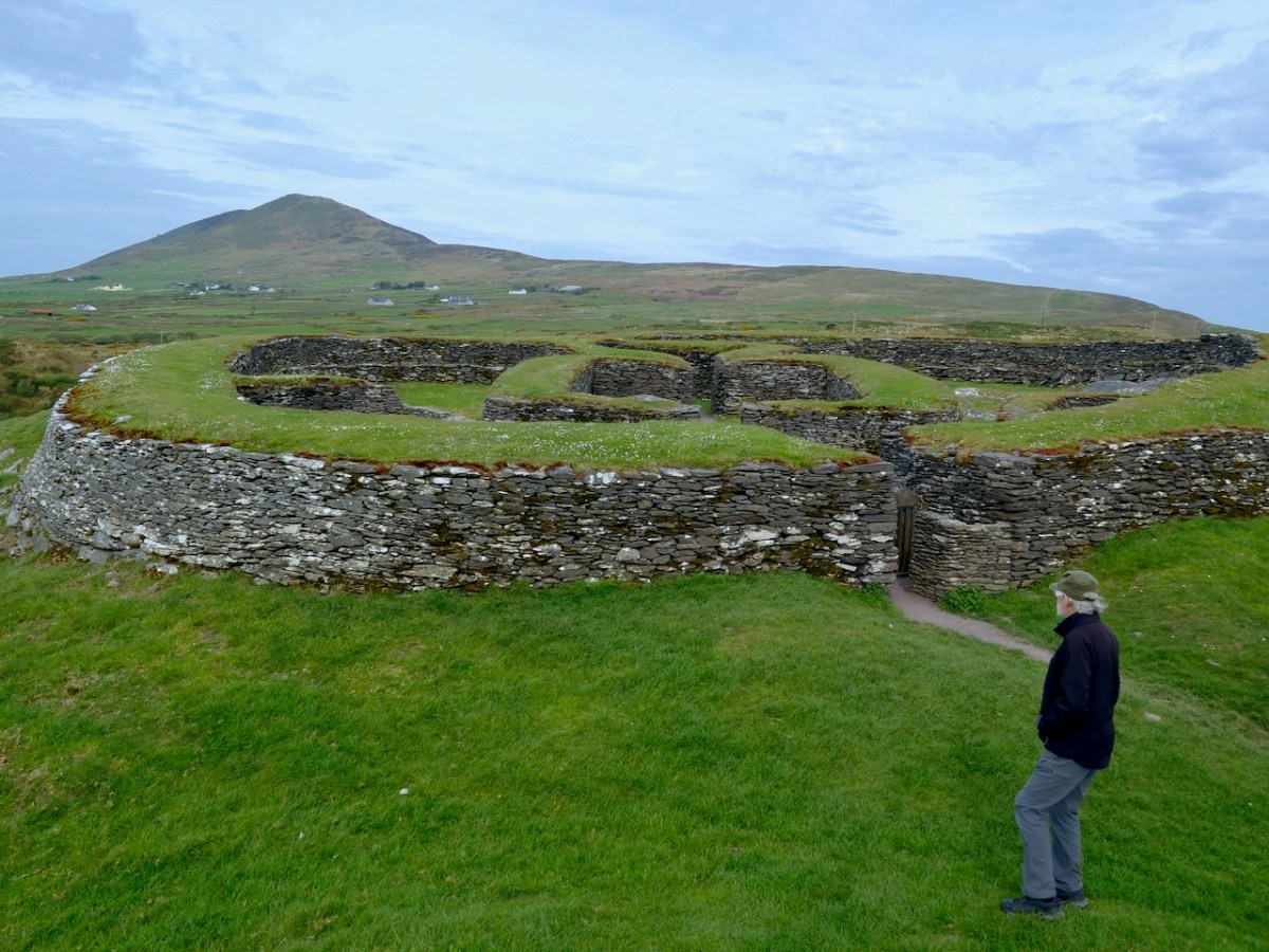
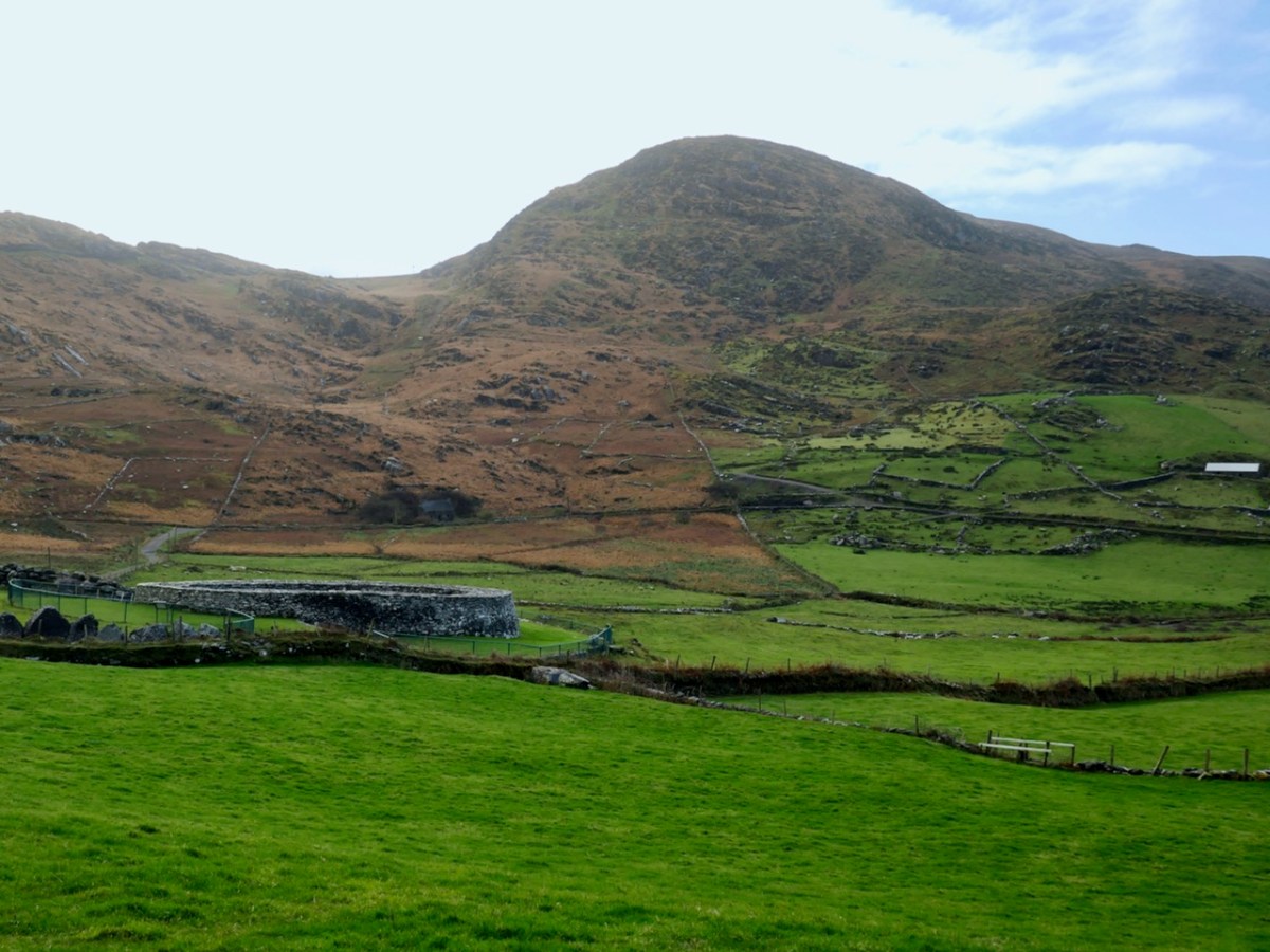
Loher Fort was excavated for four seasons in the 1980s by an archaeologist from UCC. Yes, that’s right, four seasons! You might reasonably expect, therefore that this would be the fort that would yield a thick report full of details and illustrations of what was found, some radiocarbon dates, some historical context – but shockingly, the only report ever forthcoming was a few paragraphs provided to Excavations.ie. I quote it in full now.

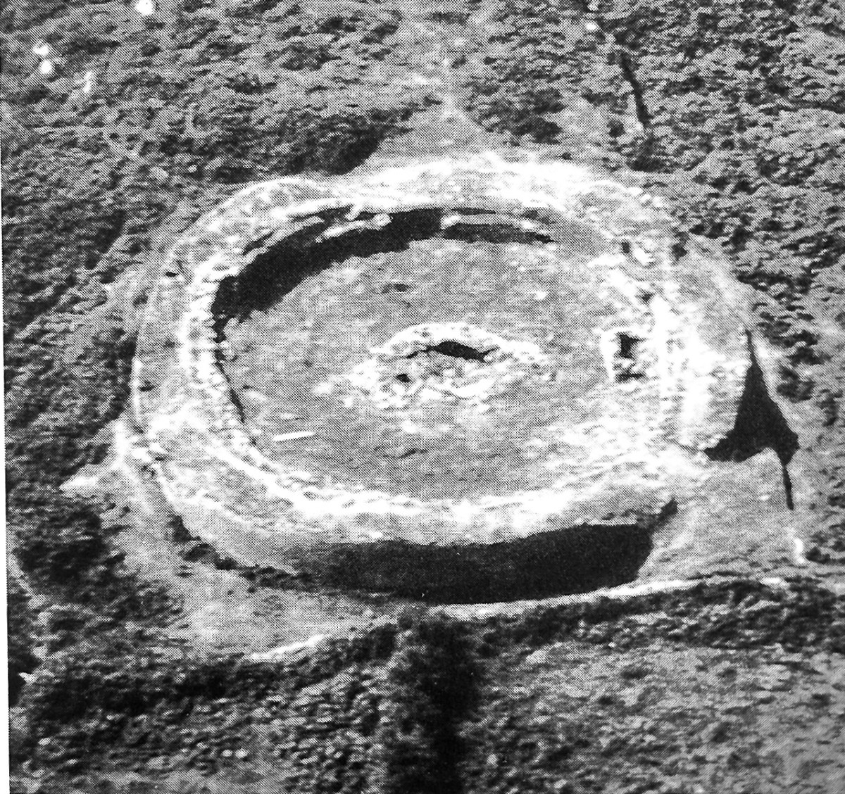
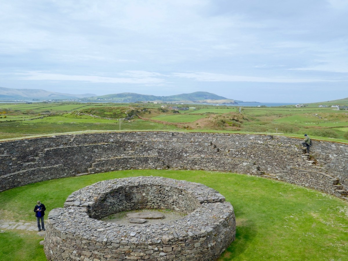
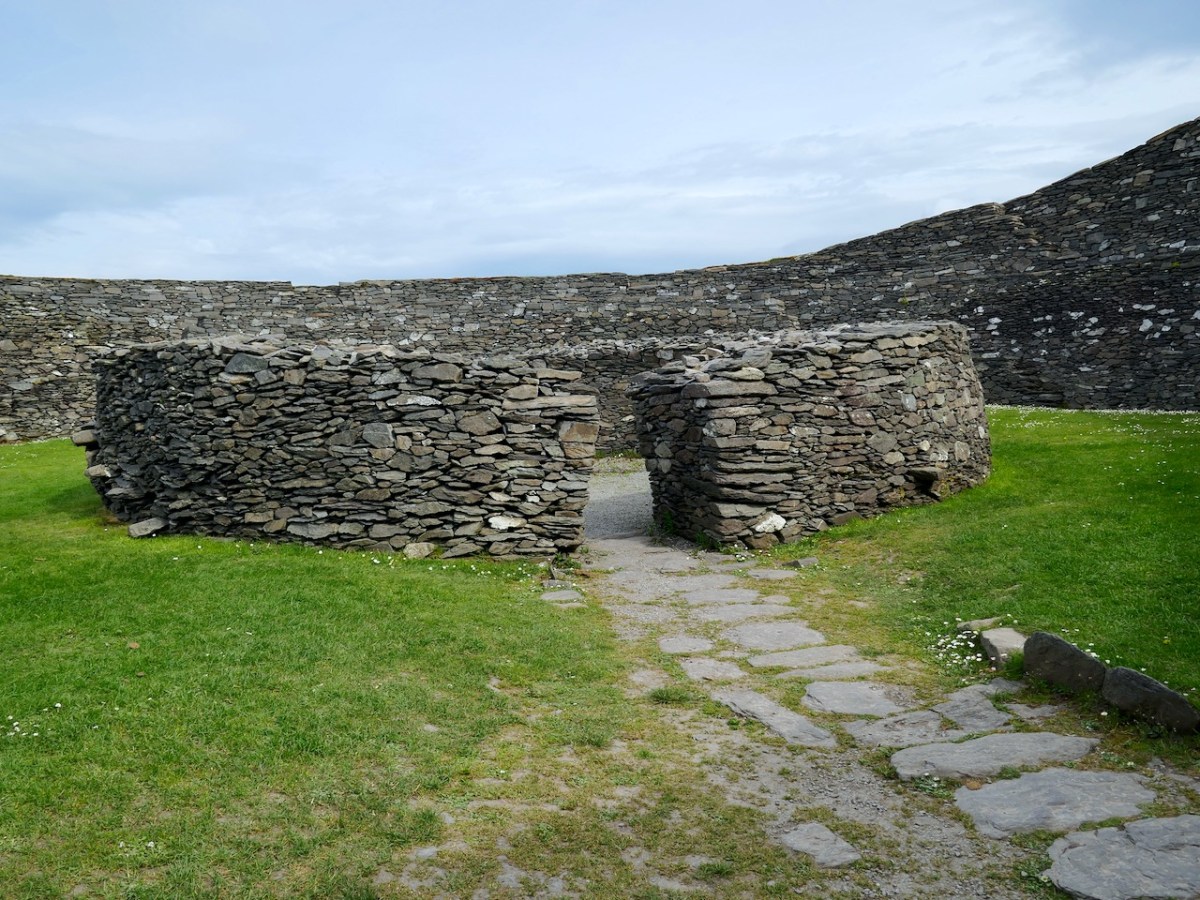
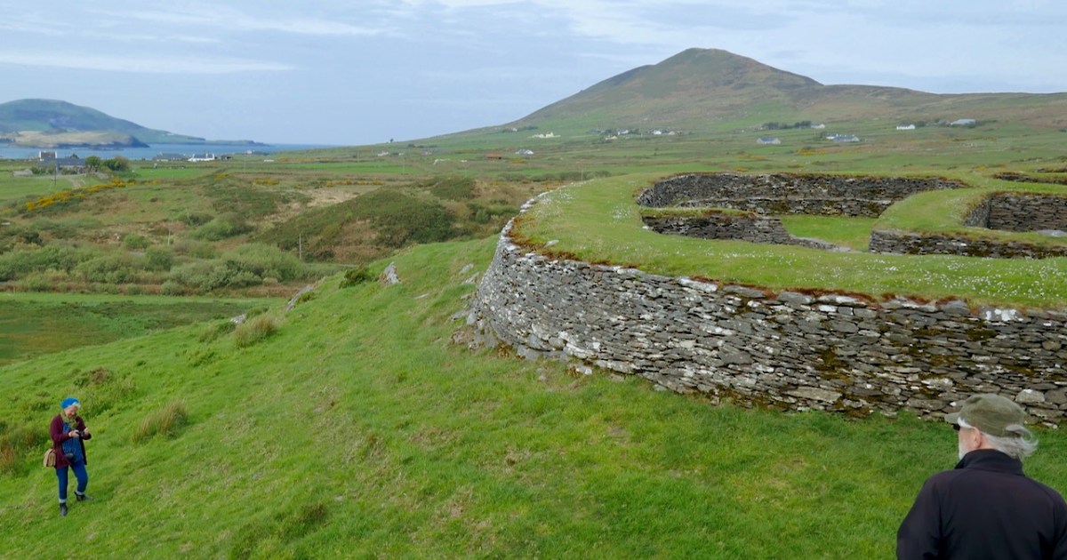
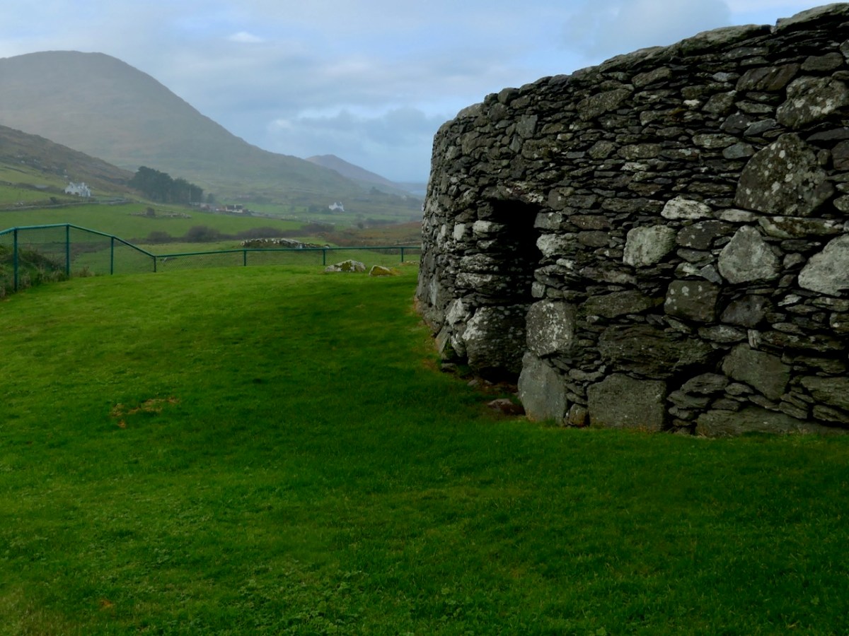
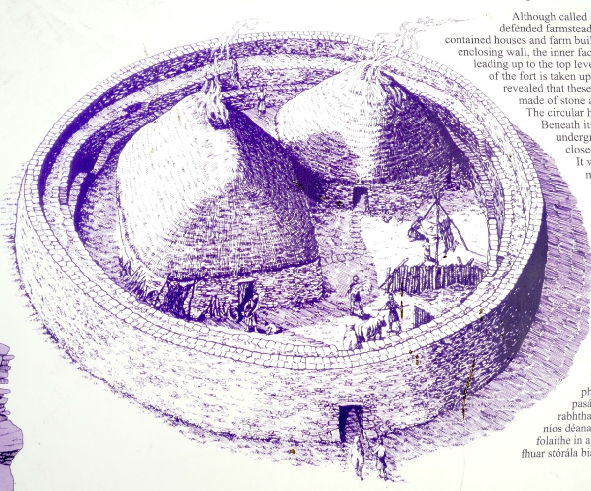
The fourth season of excavation was completed during 1985. The site may be classed as a cashel, 20m in internal diameter, with rampart walls, 2m thick.

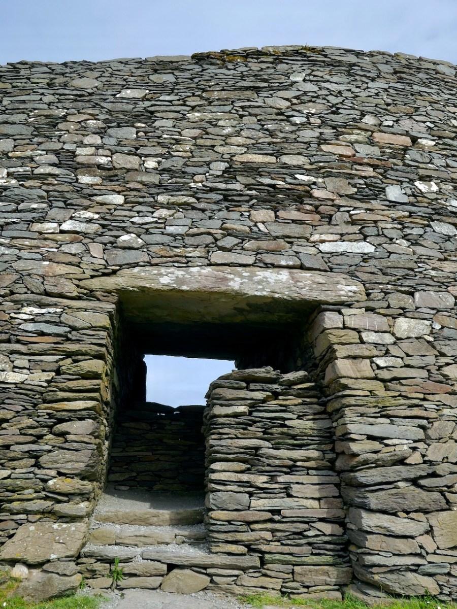
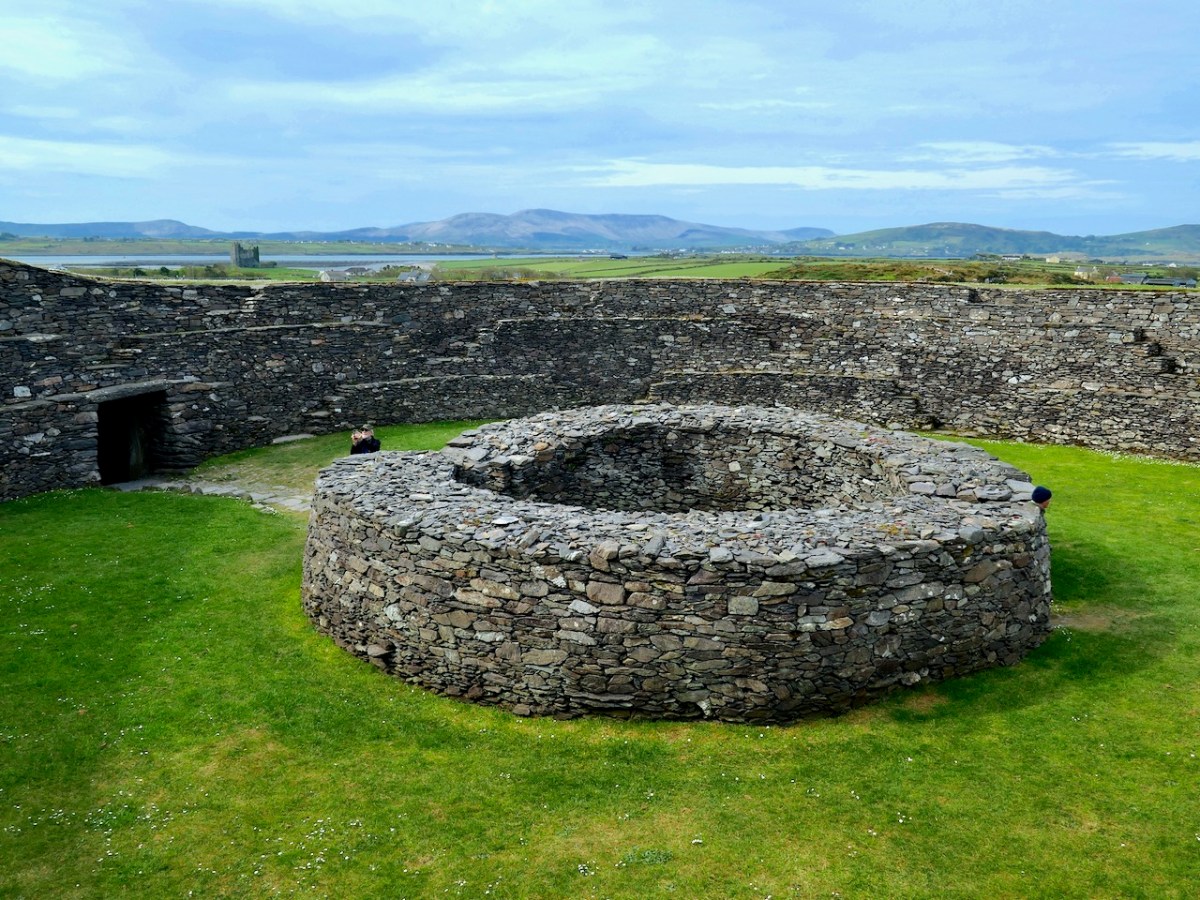
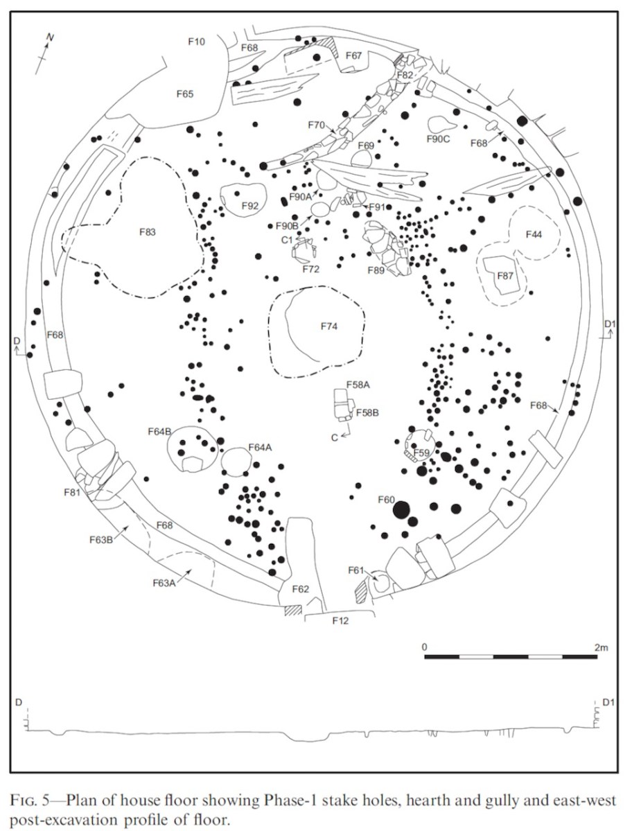
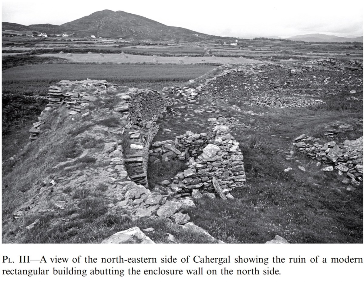
Prior to excavation the interior of the site was composed of stone fill to a depth of 2m. On removing this fill, 2 stone structures were uncovered. Both of these had walls surviving to a height of 1m and 1m in thickness. One structure is circular (clochan type) and the other rectangular. The circular structure is c. 5m in diameter and the rectangular structure is 7m x 6m in extent.

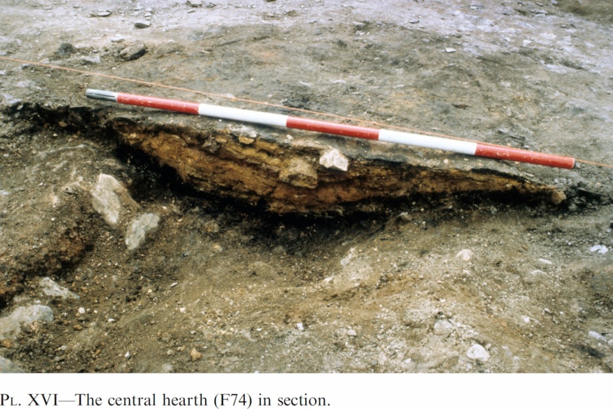
The interiors of both these structures have been excavated. This revealed no great depth of occupation deposit but did reveal a good stratigraphic sequence of structures. Essentially, there are 5 identifiable structures including the above two. In the area of the surviving circular structure, an earlier stone-built circular structure was uncovered. This was pre-dated by a wooden structure constructed of driven stakes.

The rectangular structure was pre-dated by a circular wooden house, again of driven stakes. There is also the possibility of another post-built structure in this area. Apart from the above mentioned stratigraphic relationships, the latest circular structure pre-dates the rectangular stone structure. Other features include a souterrain associated with the circular house, and a parapet walkway and mural steps.

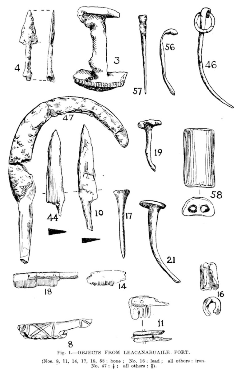
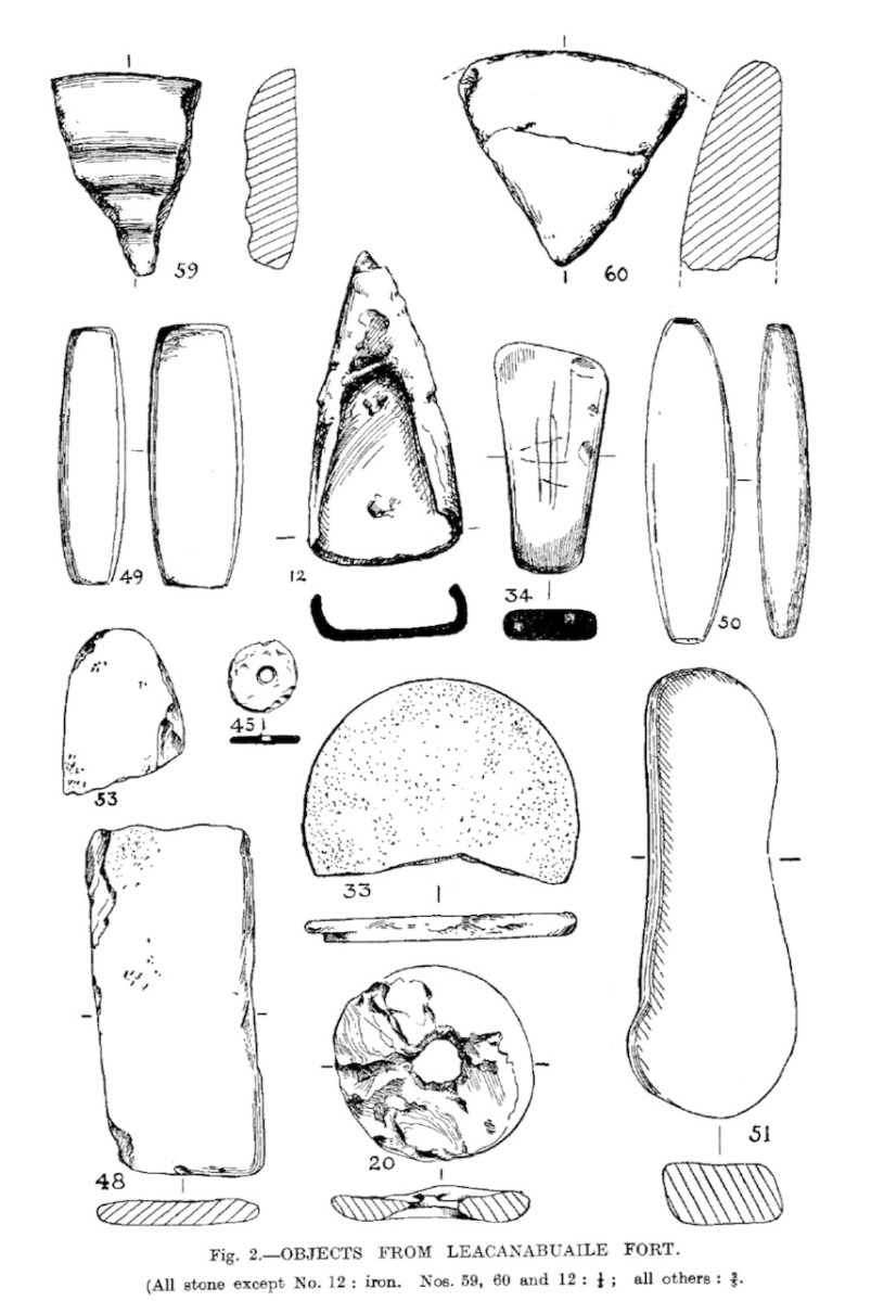
Finds include glass beads and a tanged knife. Organic material includes shell, carbonised seed remains, fish scales and fish bones.

https://excavations.ie/report/1985/Kerry/0000602/

That’s it – that’s all we know, apart from a very broad assigned date in the overview of Medieval (AD 400-AD 1600)

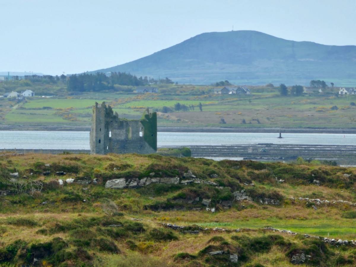
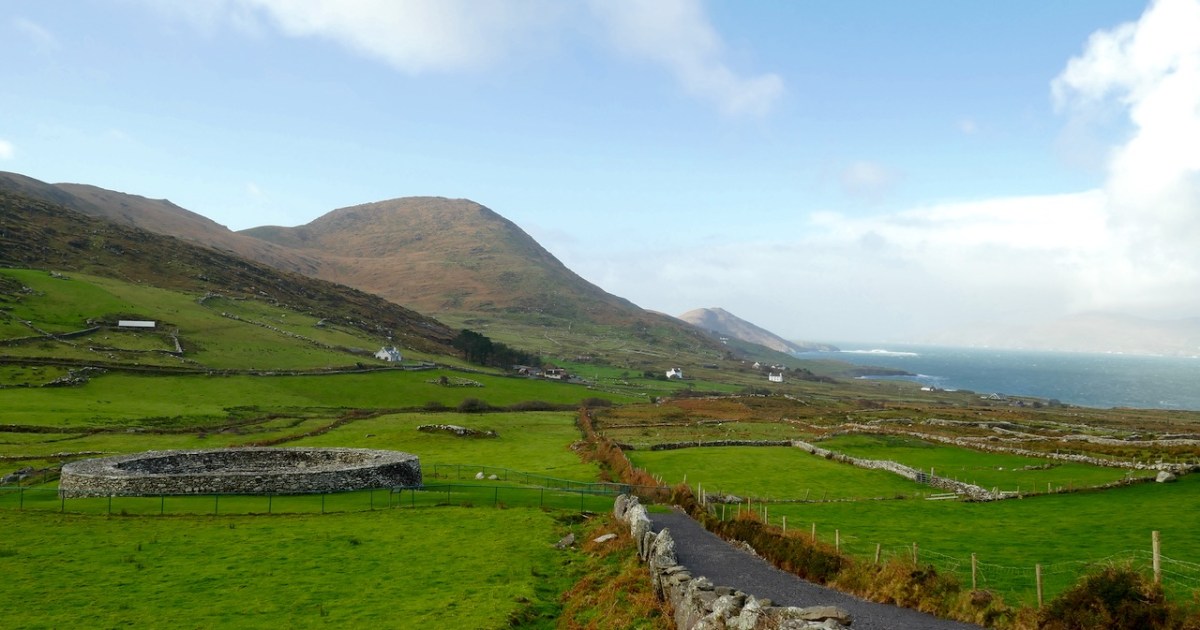
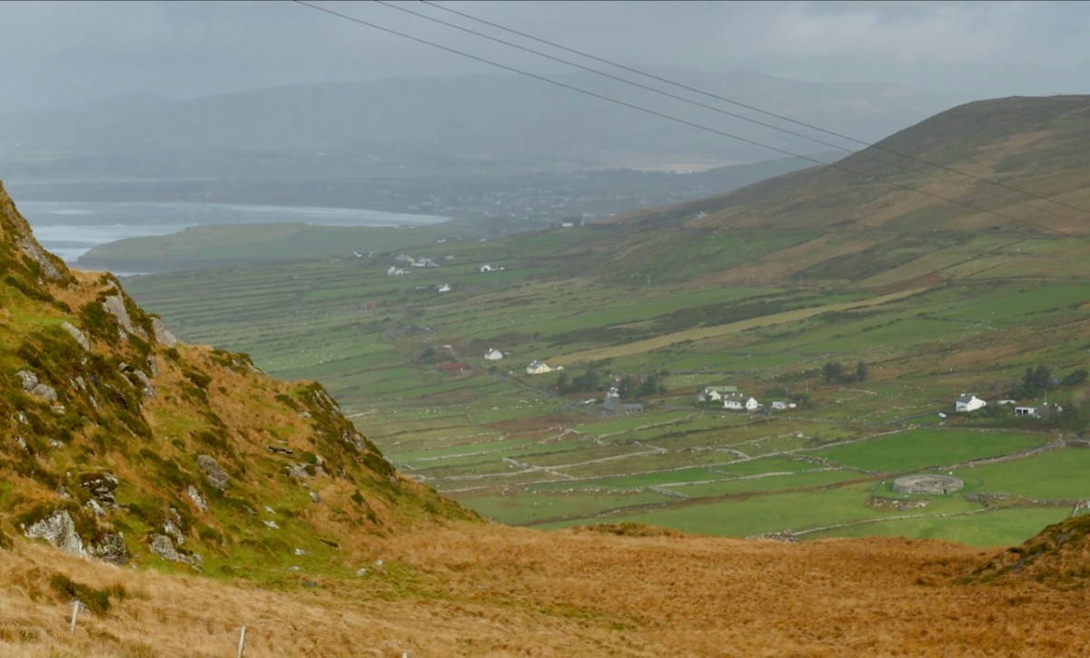
Interestingly archaeologist Aoibheann Lambe, the rock art expert, has identified a number of pieces of rock art in an around the fort, including on stones used as building materials. While these pre-date for fort by several thousand years, it is evidence that people were living in this area for millennia. It’s easy to see why – it’s a spectacular setting, with access to the sea and a location that provides a strategic point of domination over the surrounding landscape.

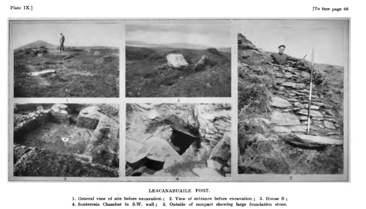
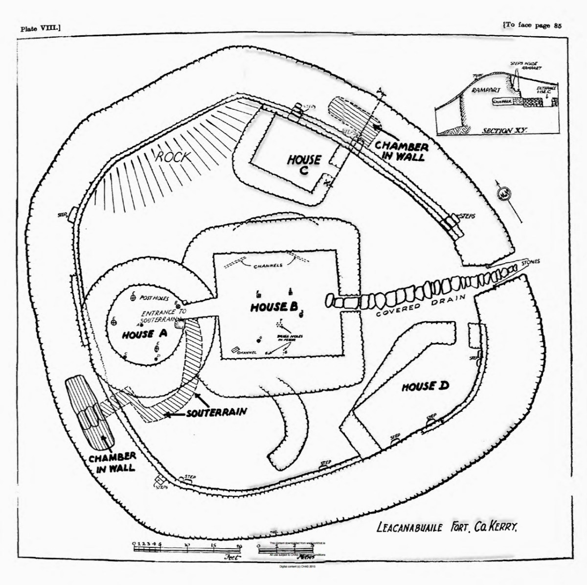
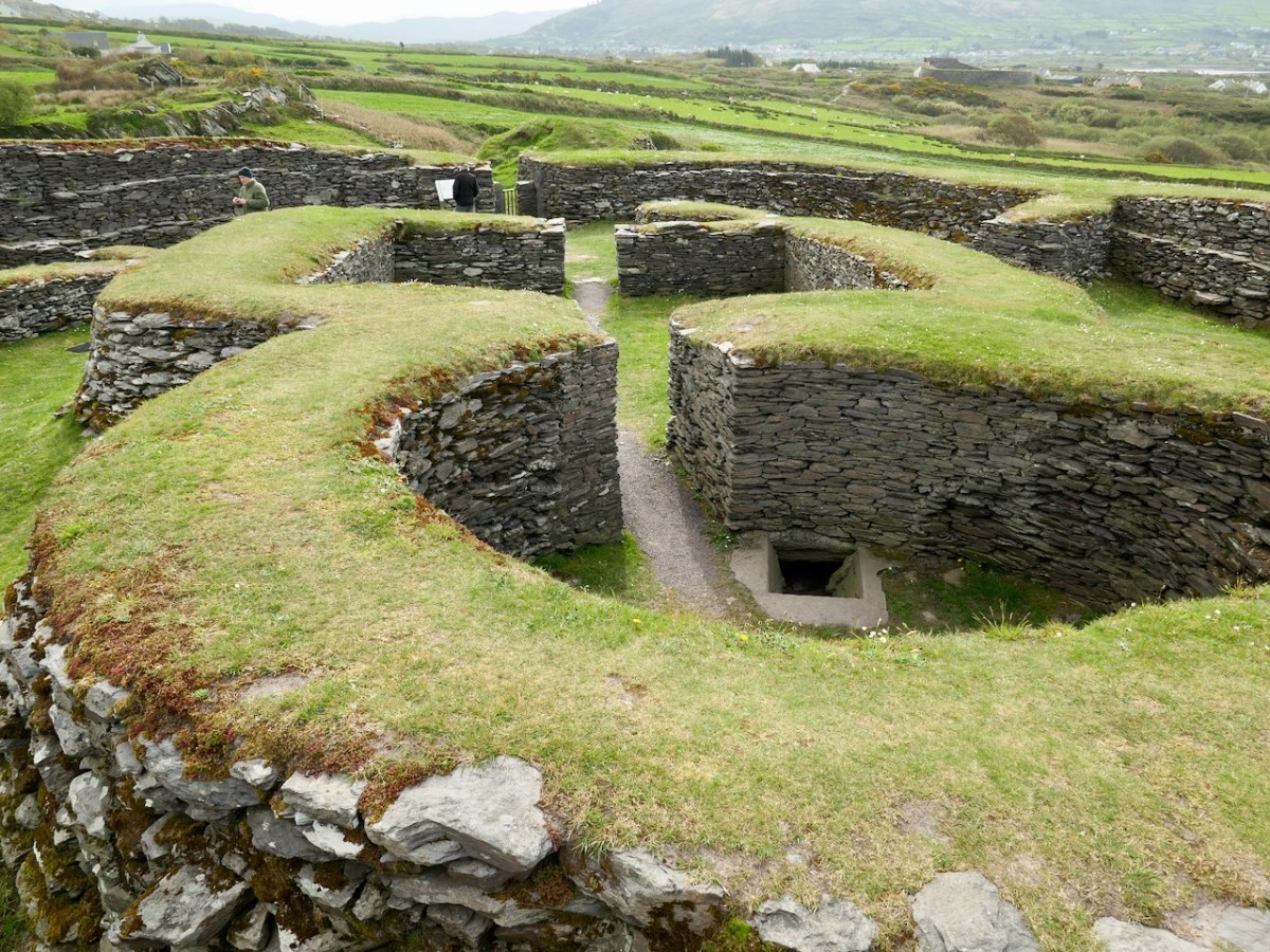
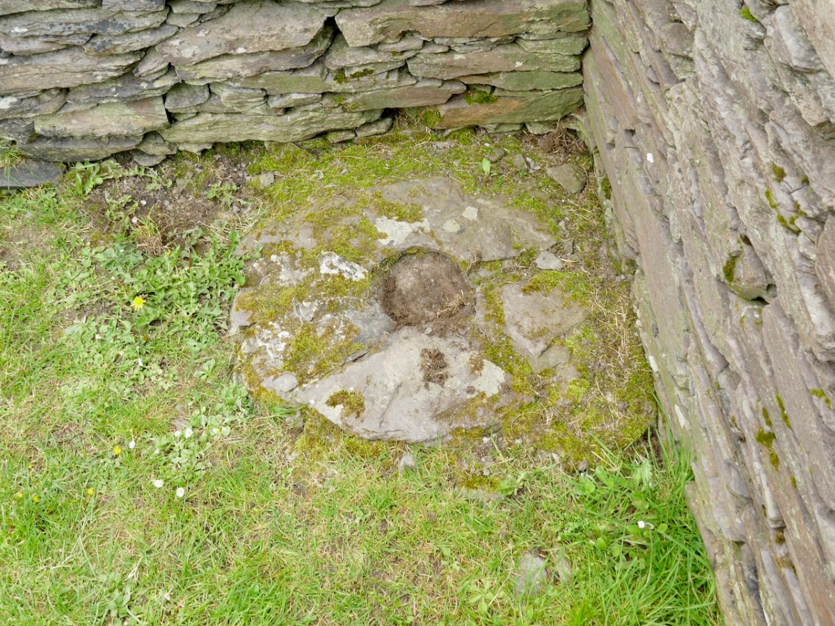
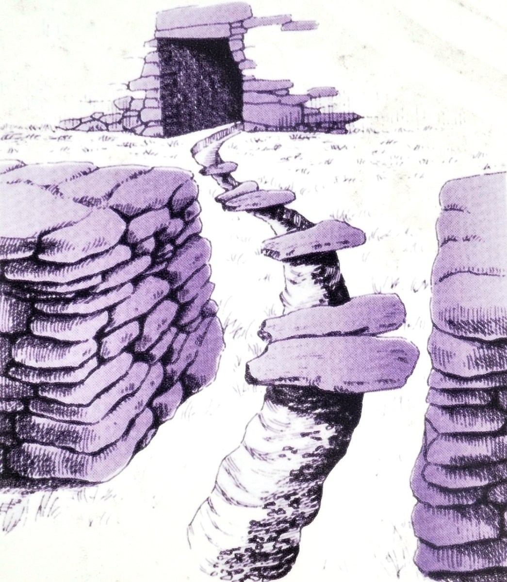
As at Leacanabuaile, there was also a souterrain, although there is no indication on the ground now of where it was, and we have no record of what it looked like and no plan. It was under the round house, which is the earlier of the two houses. Here’s what the National Monuments records says about that:

The entrance to a souterrain is located in the W half of the interior of the house. Measuring 1.1m x 1.3m, it gives access to a drystone-built lintelled passage, 1m high, which runs E-W for 3m before turning sharply to N. The excavation revealed that the construction of the souterrain post-dated that of the house, and that an earlier stone-built circular structure in the area of the house was, in turn, pre-dated by a wooden structure constructed of driven stakes.*

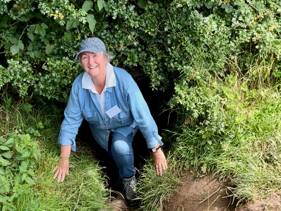
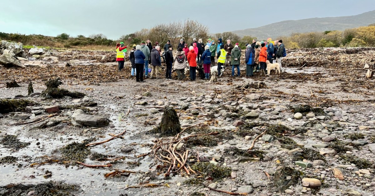
What is a souterrain exactly? As the name suggests, it’s a man-made underground passage, often associated with ringforts and cashels. They may have had a variety of uses, but perhaps the main one was as a root cellar to preserve food. That’s me, above emerging from one of the most famous of of our Irish souterrains, Oweynagat at Rathcroghan. They’re a common class of archaeological monument – there are over 1,000 in Cork and over 800 in Kerry. Folklore is rich with stories of souterrains that stretch for miles, that end up in the sea or in a nearby castle, but alas although we know of complex examples with passages leading to multiple chambers, most are quite short and contained within the general area of the ringfort. For more on souterrains, see this wonderful site. 

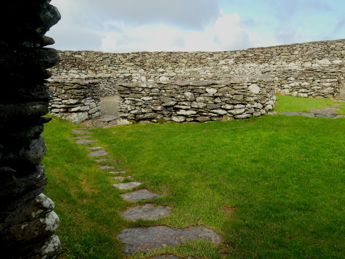
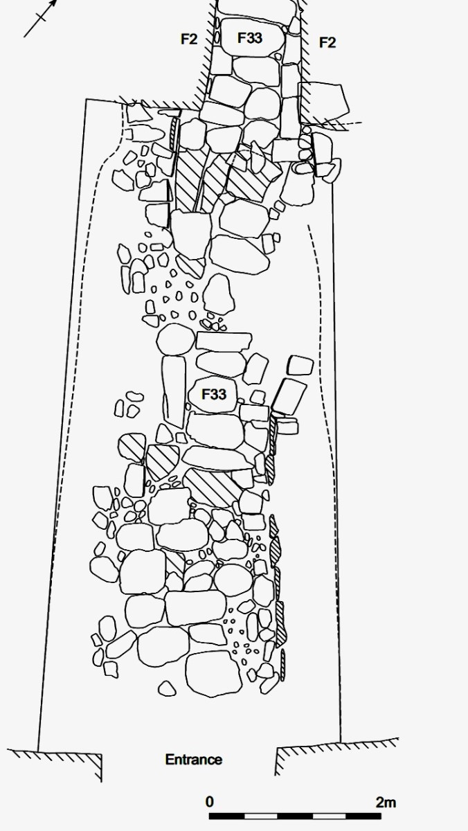
There was also a covered drain leading from the fort entrance to the house, and another between the two houses. Not quite the fine paving that was found at Cahergal, but certainly a way of keeping your feet dry on what were no doubt well-worn paths. There’s no mention of this in the brief report, but obviously the OPW, who conducted the reconstruction, knew about this, as did National Monuments who commissioned the interpretive plaque. Is there, in fact, more information available somewhere? I would be happy to stand corrected.

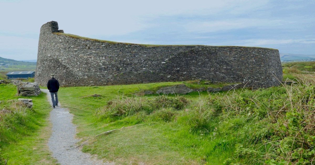
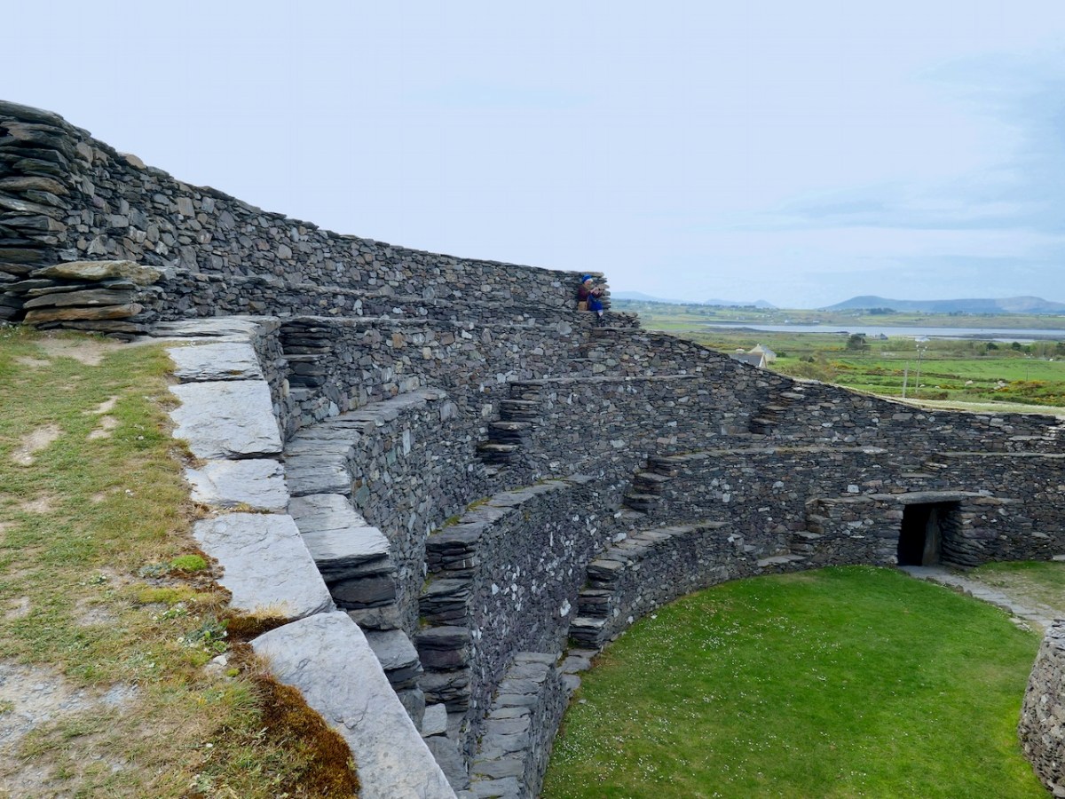
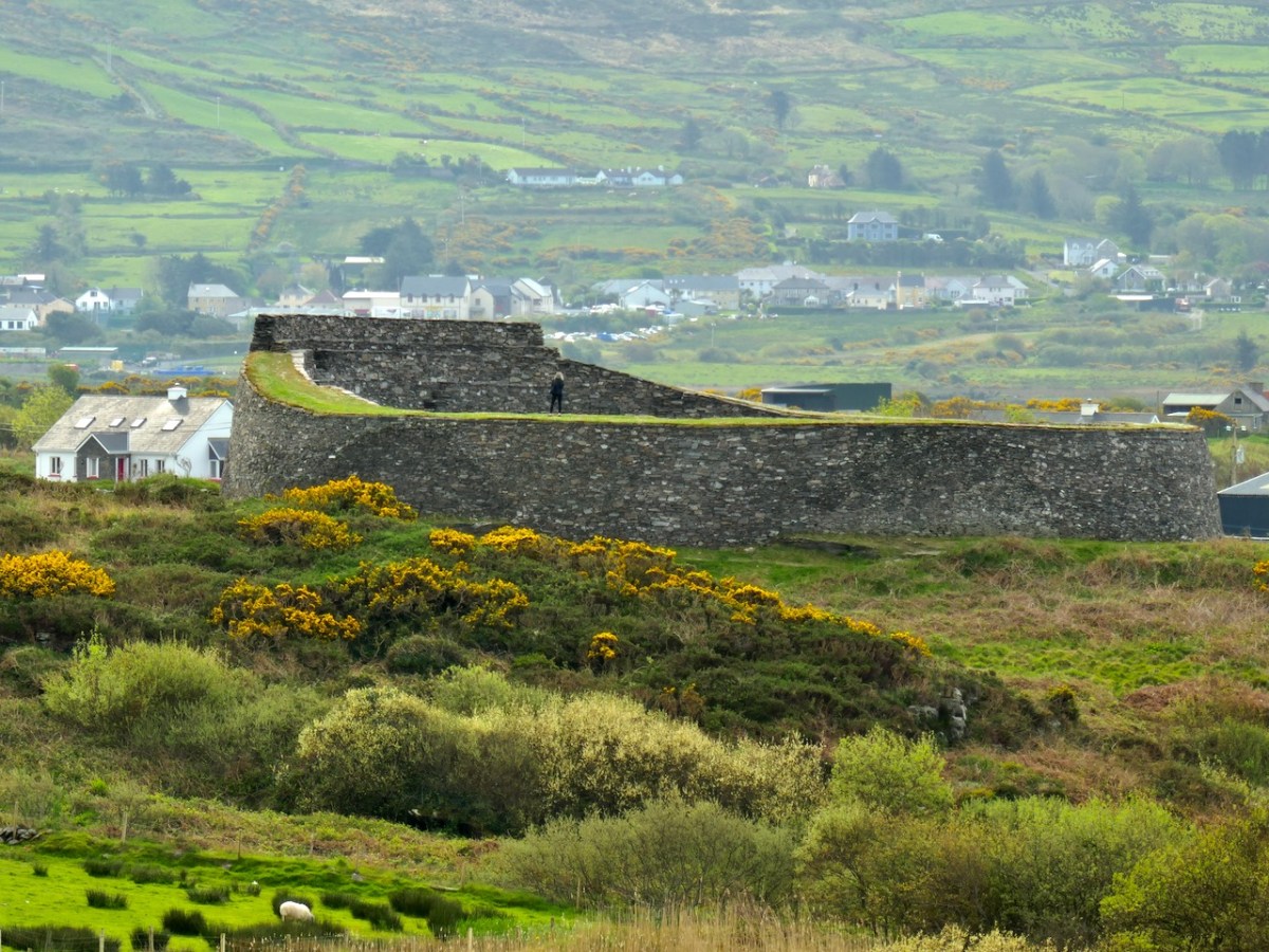
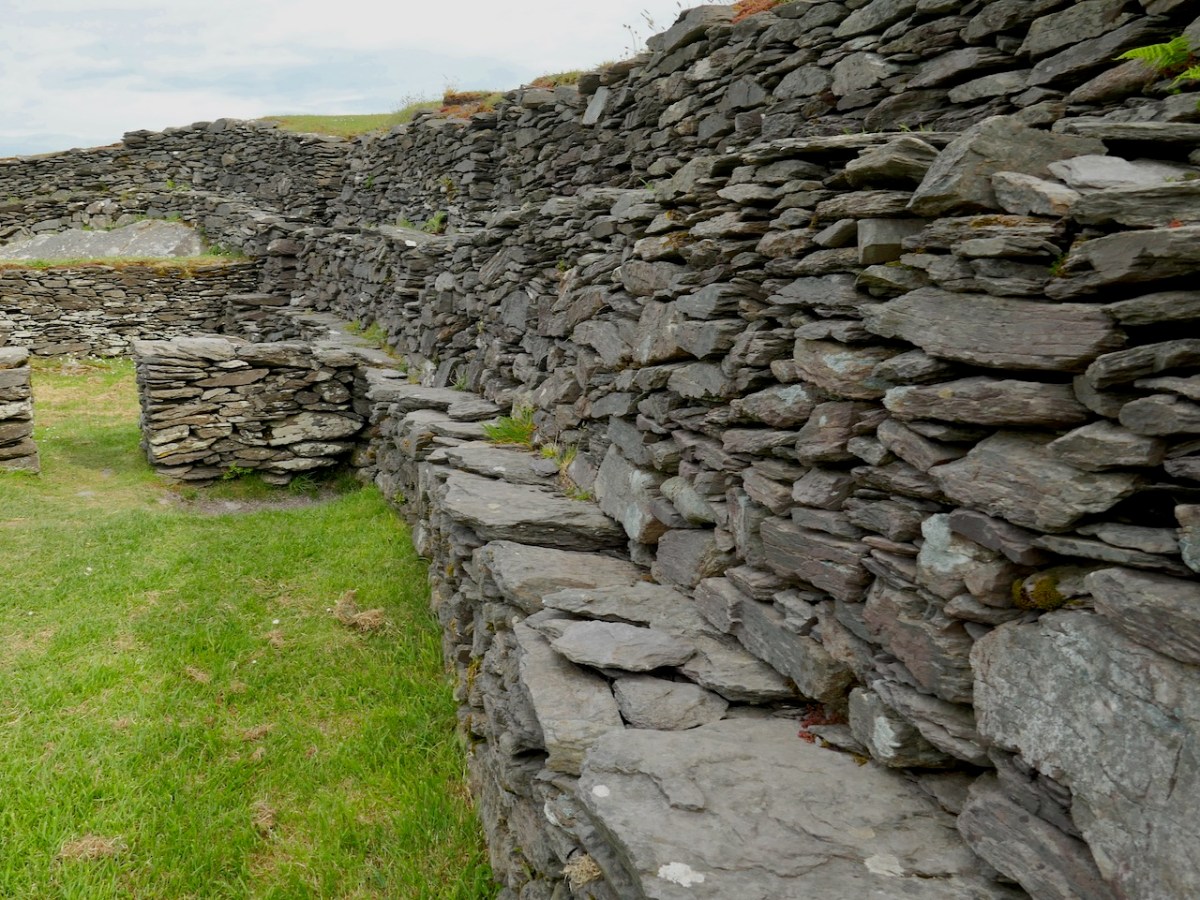
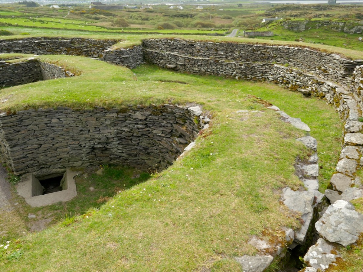
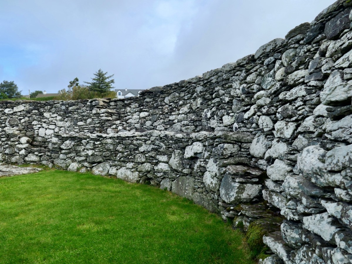
The walls and stone steps, which are a standout feature of these Kerry Cashels, are described in the National Monuments record. Note they use the word Caher instead of Cashel – both mean ‘stone fort.’

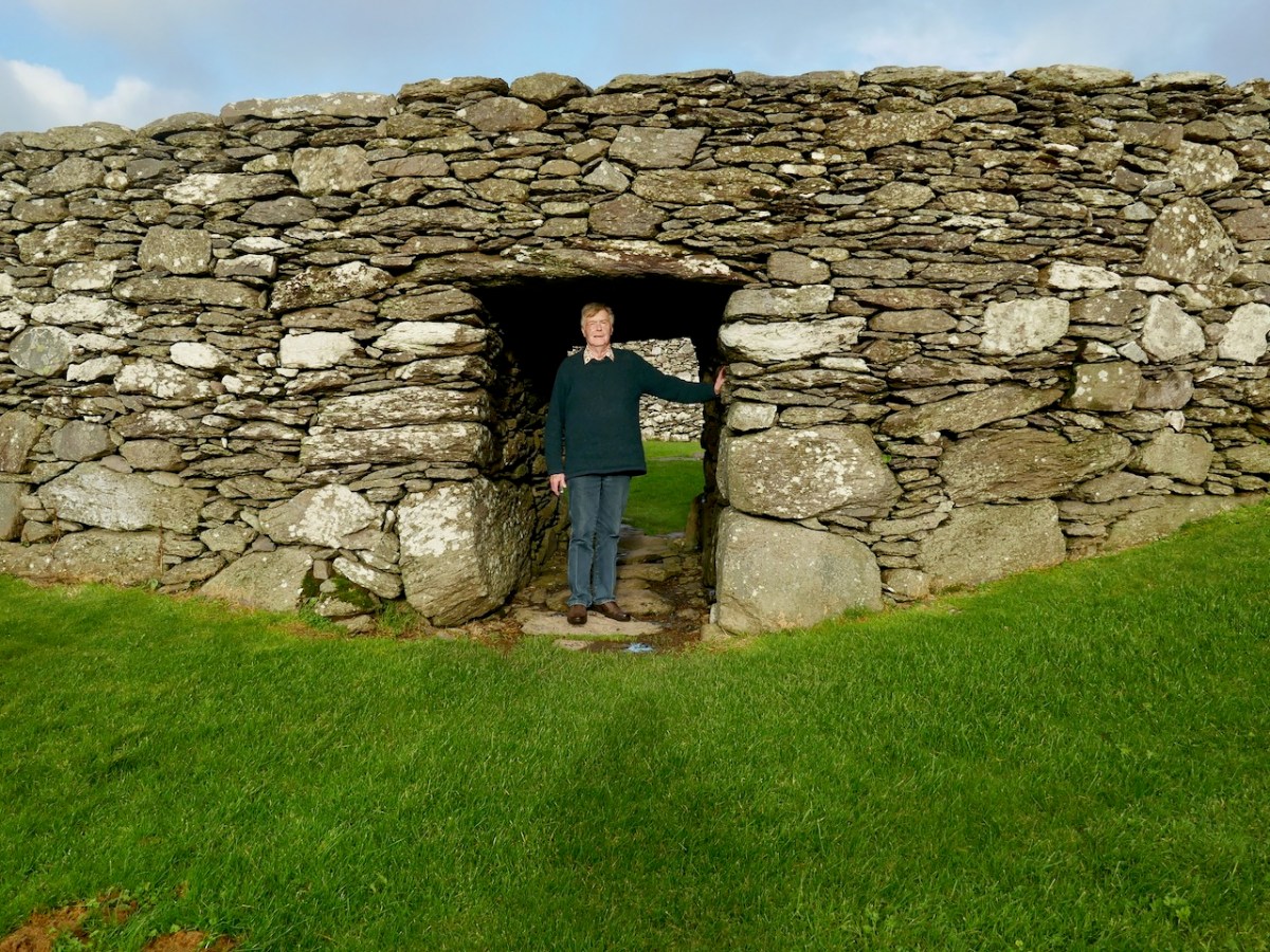
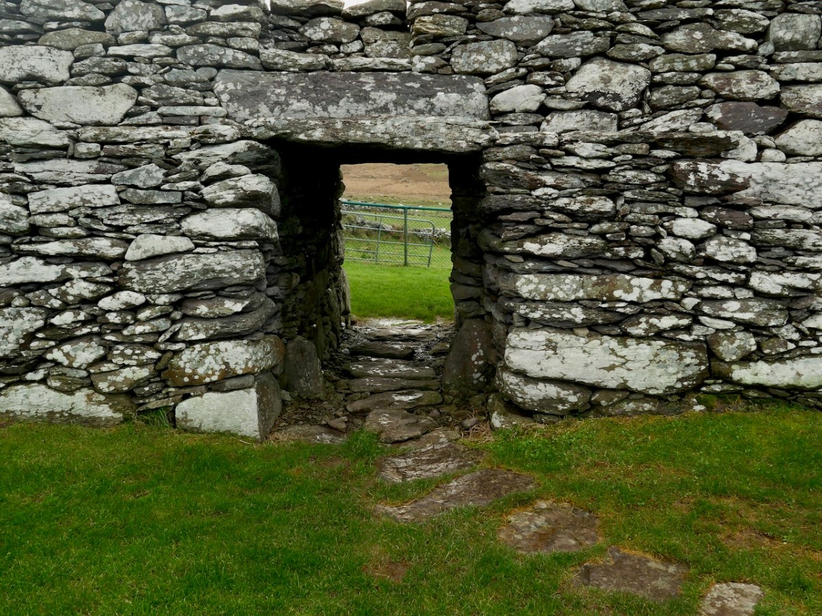
Caher Wall: This consists of a rubble core faced internally and externally with random courses of well-built drystone masonry. Much of the external face, which is battered, is concealed by a substantial build-up of collapse and field-clearance material. The wall, which is up to 4m in basal thickness, varies in external height from 1m to 2.5m and internally from 2.5m to 3.3m. A lintel-covered paved entrance passage. . . leads into the interior of the site from SSE. A terrace, reached by means of seven inset arrangements of opposing steps, occurs on the internal face of the caher wall at an average height of 1.3m. The arrangements of steps occur at irregularly spaced intervals, and the individual sections of the terrace to which they give access average .6m wide. Traces of a short section of a second terrace, also furnished with steps, occur above the first in the N sector of the wall.*

Because we have no access to a proper excavation report, we don’t know how closely the reconstruction efforts at Loher were based on the findings. However, from the little information we have it seems that what we see now on the ground is a reflection of what was left after multiple periods of occupation, one of which (perhaps the earliest phase) included a house built with wooden stakes. 

Like Leacanabuaile and Cahergal, it seems that once the excavation is over, the OPW moves in and ensures that what is left, if it is to be open to the public is made safe for visitors. If that was all they did, we might all, perhaps, be a little less confused now about what these forts looked like originally. But the instinct to reconstruct is strong, as well as the perceived need to tidy up the place, round off sharp corners and keep the grass trimmed to golf course standards. The information plaques the National Monuments folk provide are exceptionally well designed and full of welcome information.

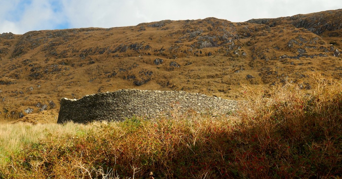
What we can say is that it’s a wonderful site, impressively built and situated, and adds to the sum total of what knowledge we have of how high-status individuals constructed statement dwellings or ceremonial spaces for themselves in medieval Ireland. 

  • The description is taken from the online inventory maintained by National Monument for all archaeology sites in Ireland, available to search here:

All four posts in this series can be found here.

Exploring Ancient Drowned Landscapes

‘Drowned Landscapes’ – that’s an adequate enough description for us to look again at a subject which RWJ covered five years ago in this post: Tralong Bay, Co Cork – give it a read. I was reminded of the subject when we took part in an Archaeology Festival based in West Kerry just a week ago: Amanda’s current holy well blog describes the expeditions. One of the sites visited was Bunaneer Drowned Forest, where we saw stumps of trees on the beach there which were alive thousands of years ago. At low tide many tree remains become visible at Bunaneer, near Castlecove village on the south coast of Kerry’s Iveragh Peninsula. Our guides for this expedition were plant biologist Calum Sweeney and archaeologist Aoibheann Lambe.

This large jumble of roots (above) is known as Goliath. All the remains here can be seen at regular low tides: at other similar sites elsewhere in Ireland, remains of ancient tree boles and roots are only revealed when tides are exceptionally low. I find it remarkable to be able to see and readily touch these archaic pieces of timber: we are communing with distant history!

Carbon dating has shown that these remains were alive between three and a half and five millennia ago. This is evidence that sea levels were significantly lower then, and that the shore line was further out – perhaps 50 metres from where we see it today. We are constantly – and quite rightly – being warned about rising sea levels resulting from our changing climate in the long term: here we see clear verification that it’s a continuing – and now apparently accelerating – process.

Our friends Robin and Sue Lewando were also on this expedition. Robin has a particular interest in sea-level changes in the Late Quaternary and subsequent eras, and he pointed me to a 2015 paper which explores the subject specifically in the Bantry Bay area of West Cork. That’s a good place to be looking at ancient history: remember the story of Cessair – Noah’s daughter-in-law – who came ashore at Donemark? You first read about it here! So this is a scientific diagram which sets out how sea-levels have been changing over time in our locality:

It’s an interesting comparison to take our horizons wider in our study of changing sea levels across the islands of Ireland. Over on the east coast – north of Bray, Co Wicklow – there is another substantial area where tree remains have been revealed at certain tidal conditions.

Above are the areas of beach between Bray and Killiney where ‘drowned forest’ remains have been observed. While at Youghal, Co Cork, further finds have occured:

This example catches our interest because the name of the settlement – Youghal – is derived from the Irish word ‘Eochaill’ meaning ‘Yew Woods’: they were evidently once common in the area, leading us to wonder whether the tree remains in this instance are of yew. In 2014 the following account of another ‘ancient drowned forest’ discovery appeared in the Irish Times (photograph courtesy of Joe O’Shaughnessy):

. . . Walking out on to the shoreline at low tide, geologist Prof Mike Williams points to the oak, pine and birch stumps and extensive root systems which were once part of woodlands populated by people, wolves and bears. These woodlands extended out into lagoons and marshlands that pre-dated the formation of Galway bay, Prof Williams says.

An extensive layer of peat also exposed at low tide in the same location in Spiddal was formed by organic debris which once carpeted the forest floor. The stumps at Spiddal are surrounded by root systems which are largely undisturbed. The carpet of peat is covered in strands of a reed called phragmites, which can tolerate semi- saline or brackish conditions.

“These trees are in their original growth position and hadn’t keeled over, which would suggest that they died quite quickly, perhaps in a quite rapid sea level rise,” Prof Williams adds. Up until 5,000 years ago Ireland experienced a series of rapid sea level rises, he says. During the mid-Holocene period, oak and pine forests were flooded along the western seaboard and recycled into peat deposits of up to two metres thick, which were then covered by sand.

Prof Williams estimates that sea level would have been at least five metres lower than present when the forests thrived, and traces of marine shell 50cm below the peat surface suggest the forest floor was affected by very occasional extreme wave events such as storm surges or tsunamis. He says most west coast sand-dune systems date to a “levelling” off period in sea level change about 5,000 years ago. Dunes in Doolin, Co Clare, are older still, having first formed around 6,500 years ago.

Prof Williams has located tree stumps in south Mayo and Clare, along with Galway, which have been carbon dated to between 5,200 and 7,400 years ago at the chrono centre at Queen’s University, Belfast. Some of the trees were nearly 100 years old when they perished . . .

Lorna Siggins
Irish Times 07/03/2014

Goliath, West Kerry, November 2023

Beware!

It’s time for another review of signs we see around us. Signs are often put up to warn us to be careful (there are some of those here), but they don’t always need words. This large fishy fellow above looks as if he might bite! And I’d be careful in the vicinity of this ceramic pail below . . .

Sometimes it’s not just signage that catches the attention – this little ensemble makes you look twice:

As does this happy couple celebrating in a field not too far from here . . .

An old sign revived (above): it seems so poignant somehow.

Not sure what stories are being told in the two images above. Certainly, they are arresting.

Some objects speak for themselves.

Please! I know you were going to throw those wellington boots at the hens . . .

A somewhat dramatic juxtaposition which we came across in Kerry. (Below) just imagine . . . !

One could start a collection of mail boxes.

No comment required.

Where do you suppose this sign is situated (below)?

Another fishy tail (above) and a dire warning (below)!

Cashels in Kerry 2: Cahergal

Cahergal is undoubtedly one of the finest examples of a stone ringfort or cashel in Ireland. What makes it outstanding is not the overall size of the enclosure or the height of the enclosing wall but the quality of the drystone masonry, the width of the entrance, the thickness of the wall and the well-planned and executed almost symmetrical stairs and terraces on the inner side of the wall.


Excavations at Cahergal, Co. Kerry:
A Venue for Royal Ceremony in Early Medieval Corcu Duibne

All quotes in this post are from the 2016 excavation report by Conleth Manning of National Monuments*. Con’s report deals with the 1986 brief excavation near the entrance, and his own 1990-1991 excavations inside the cashel. The excavations established a date for the fort – it was originally built between the mid 7th and the mid-9th centuries – as well as providing evidence for its status and uses. It also established the basis upon which most of the restoration work was done – although note I say ‘most.’ In the photo above you can clearly see the old and newer stonework.

Like Leacanabuaile, this was a rather tumbledown ruin before excavation and restoration projects. All that incredible masonry work did not save it from the ravages of time, although the exceptionally high standards of building became clear as it was dug out from the jumbles of stone and grass that covered it.

The initial stages of building included the walls, with its staircases, the entry passageway and the fine paving, as well as the round house in the interior.

The stairs and terraces on the inside of the walls are one of the striking features of this fort. There are two levels of terraces along most of its length, but in one area the stairs went up to three flights. The excavation report states, The third set of steps probably led to a wider viewing terrace, which was likely to have been flanked externally by a parapet wall.

After the excavations the OPW continued to work on the restoration of the fort and this finding was interpreted to mean that this section of the walls was much higher than other sections. This led to a decision to raise the top of the wall in this section, leading to the somewhat startling profile we see now. According to Con Manning this is a skewed interpretation by the OPW and it is highly unlikely that it reflects what the wall actually looked like.

The entrance to the fort had completely collapsed but excavation revealed how deep it had been. A pair of upright jamb stones and fallen lintels were found, leading to the reconstruction as we see it today.

The house was circular and the amount of fallen stone inside led to the conclusion that the roof was originally made of stone, probably using a corbeling technique. If this was the case, this house is the largest round building known to support a stone roof, well known from church sites (such as Kilmalkeader) where the stone roofs are rectangular and steeply pitched. 

A very finely laid-down pavement led from the fort entrance to the door of the house. The pavement was delineated at the side by edge-on kerb stones.  The house originally had three doors, with the main one positioned across from the entrance to the fort, and accessed by walking along the pavement.

Internally, there was a central fireplace (Feature F74 in the pan below). Stake holes around this central feature were probably to support a beam or spits for cooking purposes. The fireplace itself showed that numerous fires had been burned in it. Other stake holes supported furniture for sitting or sleeping.

The strange thing about Cahergal is that the excavations yielded very few finds (compared to Leacanabuaile, for example) and what was found mainly dated to later periods of occupation. So – what was going on during the original period of occupation – mid 7th to mid 9th centuries? Manning speculates that this was actually a royal site, built to impress, to inspire awe, and perhaps to entertain. Ritual feasting would take place in the main house, which would be cleaned carefully afterwards and readied for the next great occasion.

The three doors might support its interpretation as a royal site. Manning says:

In each case the side entrance might have been for people of lower status, with the main entrance being reserved for kings, nobles and important guests. On the other hand one could regard the three doorways as symbolic, three being a magical number as in the triads, and in this case could symbolise the three divisions of Corcu Duibne. In the tale of Branwen daughter of Llyr, in the medieval Welsh Mabinogion, a royal hall with three doors is mentioned in the house of Gwales (Grassholm), where one door, facing Cornwall, was kept permanently closed with a taboo on opening it.

This interpretation of the function of the fort and house – designed to impress and to underscore the prestige of the builders – reflects the later castle-building of Irish chieftains. Here in Ivaha, for example, the O’Mahony clan built tall, overpowering castles to cement their control over the land and the sea around them. Cahergal is within sight of two other cashels – the Castles of Ivaha were often within sight of each other too. Annals tells us that the Taoiseach of the O’Mahony clan built a castle for each of his sons, or other members of his ‘derbfine’ – the family group from which the chief was chosen. 

As if to confirm this possibility, Ballycarbery Castle, a 15th century tower house, lies within clear sight towards the coast. Was this a continuation of the same tradition by the same family – the Falveys? Manning concludes his report by stating:

This [high-status] phase ended with a burning of the internal features and subsequent, probably occasional, lower-status use of the house between the eleventh and fourteenth centuries. Iron forging took place here in the fourteenth century. After the eastern half of the stone roof collapsed and the structure was abandoned for some time, it was roughly rebuilt as a D-shaped structure probably in the fifteenth century.

The last period of occupation was the modern period – the small building built against the wall in the photograph below was probably a sheep-pen noted by an antiquarian visitor.

The final fort we will talk about is Staigue – in many ways it’s the most spectacular (despite not being as well built as Cahergal) but it has not been excavated so less is actually known about it. Meanwhile, if you can’t get to Cahergal but want a Cahergal experience, visit the marvellous Voices from the Dawn – Howard works his 3D magic on this page.

*Conleth Manning. Excavations at Cahergal, Co. Kerry: A Venue for Royal Ceremony in Early Medieval Corcu Duibne. Proceedings of the Royal Irish Academy: 2016, Vol. 116C

All four posts in this series can be found here.

Cashels in Kerry 1: Leacanabuaile

We have been in Kerry a few times this year and visited three stunning sites – Staigue (above), Leacanabuaille and Cahergal (sometimes written Cahergall) – all of which fit the definition of stone forts, often referred to as Cashels. For non-Irish readers, cashel is pronounced the same way as castle, but with the sh sound in the middle –  don’t say cash-elle. 

Each of these also fit in to a category that has been labelled by archaeologists as the Western Stone Forts, and they were the subject of research by the Discovery Program several years ago. The forts included under this title, about 25 in all, dotted along the western seaboard, were chosen because of their their large size, or prominent location or because they have complex or massive defensive features.

In a fascinating talk available to view online, archaeologist Claire Cotter walks us through several examples of such forts. In relation to size, she points out the huge investment in effort to build those walls, once you go over about 2 metres in height. Of course the walls have to be very thick as well, to carry the weight of all that rock and to ensure they didn’t fall over. Inside, a feature of Staigue and Cahergal are the stone staircases arranged in a X shape – they make for a strong visual statement. Leacanabuaile (below) has stepped levels on the inside of the walls to give access to the parapet. Let’s take a look at each fort in turn to see what’s unique and what’s common among the three of them. 

We’ll start with Leacanabuaile, pronounced Lacka – na – boolya and meaning the flagstones of the enclosure, or possibly the flagstones of the summer pasture. Large flagstones, or leacs, do litter the way up to the fort.

Leacanabuaile was excavated in the summers of 1939 and 1940 by Sean P Ó Ríordáin and J B Foy. Ó Ríordáin was a revered Irish archaeologist and his book, Antiquities of the Irish Countryisde was our text for first year in the Archaeology Department at UCC, where he had been the professor before O Kelly. That’s Ó Ríordáin in the middle, below at the Lough Gur dig in Limerick, with O Kelly furthest to his left. As an aside, he was married to Gabriel Hayes, the sculptor – one of her major works is mentioned in this post. She did the drawings of the finds, which you will see further down.

For most of the following, and all the quotes, I am taking the information from the excavation report, which was published in the Journal of the Cork Historical and Archaeological Society for 1941. The marvellous CHAS has made their old journal available online, and this report is here. Leacanabuaile is situated in the middle of a concentration of forts, close to Caherciveen and all within a  mile or two of each other, and in the case of Cahergal, in clear sight, as you can see below.

Before the excavation it was in very poor condition – the walls had collapsed and it looked more like an earthen ringfort, with just traces of the stone wall showing through here and there. It was so unremarkable, in fact, that it was left off the Ordnance Survey maps. 

The excavation uncovered not only the massive nature of the walls, but four houses inside, a souterrain, and mural chambers. This was before the commonplace use of radiocarbon dating in Ireland so the usual way of dating a site like this was through the finds and through comparison with similar sites. Using these methods, Ó Ríordáin says:

 The close dating of the Leacanabuaile site is not possible, but it may be noted that the finds correspond to material from sites dated by more significant objects to the ninth and tenth centuries AD.

The fort is not quite round and this was due to the undulation of the rocky hilltop on which it was built, the builders having to work around the steep slopes. The souterrain and the mural chambers were built at the same time as the walls. 

Of the houses inside the fort, three were built at the same time as the fort – round house A and two others which now lie under house B. Houses D and C were the last to be built.

In regards to the material cultural objects found during the excavations, and what they reveal about the inhabitants, Ó Ríordáin states

Elaborate brooches and glass objects, for instance are notable by their absence. Bronze is rare and there is no evidence of its having been worked on the site – crucibles are not forthcoming: iron working is evidenced by the iron slag found. On the other hand, the inhabitants were probably quite well provided with the more vital necessities of life. They had . . . a dual source of supply – the sea and the land. The plough-sock and the querns show show that grain was cultivated, the bones show that domestic animals were kept and eaten, while the fare was added to by the collection of shellfish from the coast and by the capture of birds, particularly sea-birds.

The sea birds included heron, duck, goose, cormorant, puffin and razorbill, while the domestic animals were ox (most numerous), sheep, and pig. Also found were evidence of horse, dog and red deer.

What we see on the ground today is the result of conservation work undertaken by National Monuments as Leacanabuaile was taken into state care. Ó Ríordáin describes how 

. . .the walls of the fort and the enclosed buildings were restored by building up, to some extent, the destroyed portions, so as to provide a level top surface which should stand the better the ravages of time. The lines of the old work have been carefully followed and the new building has been marked off from the old with a thin line of concrete. . .[stone objects] were set in cement in House B, so that they may be conveniently inspected.

So – what you see now at Leacanabuaile is as a result of the excavation and the subsequent conservation by National Monuments. Ó Ríordáin remarks, the skill with which the workmen used the material to build in the old manner is a good example of the survival of a technique in a given environment. That reminded me of our own experience with Building a Stone Wall. I also regretted that I hadn’t read the report before I visited so that I could find that thin line of concrete and take a photograph of it for this post. 

We’ll take a look at Cahergal next, also excavated, this time by our friend Con Manning in the 1980s and 90s. This is a more complex site and the report is much longer so it will be a challenge to summarise in a blog post, but I’ll do my best. 

All four posts in this series can be found here.

Prince of Peace: A Modern Irish Church

On our travels in Kerry recently, we happened across a striking church building. It’s situated west of Killarney and overlooks Lough Leane: in fact the view of that stretch of water is a principal feature from the interior of the church. An enormous picture window is situated beyond the altar.

I have titled this piece: A Modern Irish Church. Everything is relative, of course: this Fossa Church was completed in 1977, getting on for half a century ago, but one could only fairly describe the style as ‘modern’. It is one of twenty seven ecclesiastical buildings designed by the architectural practices of Liam McCormick (1916-1996). While based in Derry the architects carried out commissions throughout Ireland: the practice of Mullarkey Pedersen Architects, Derry and Dublin, continues their work to this day. My own life experience as an architect – (I carried out a number of church projects) – tempts me to embark on a tour of McCormick’s buildings, many of which are visually dramatic..

The lakeside church was designed to supersede an earlier building – St Lelia’s – which dated from the 1840s. That building remains and is in communal use (above): it is set back from the present site.

Unusually, there is no contemporary stained glass in this building. Instead, the focal point is the central view. I wonder whether this might be a distraction while the priest is in action? It may be that he would always be in silhouette in daylight: there is no means of subduing the window. The church does contain some distinctive artwork, however.

The Stations of the Cross are notable. They are the work of Nell Murphy Pollen (1927-2011). A ceramicist, woodcarver and sculptor, she was a native of New Ross and studied at the Crawford.

Perhaps one of the most striking aspects of the church at Fossa is the little Blessed Sacrament Chapel: “. . . a chapel of reconciliation dedicated to the Prince of Peace . . .” This (above) is decorated with murals by Patrick Pye (1929-2018). They are produced in a traditional medium which dates from the time of the early Renaissance, tempera on a gesso ground.

Pye’s tempera/gesso painting Peter receiving The Keys from The Christ – The Blessed Sacrament Chapel, Fossa. Patrick Pye is an artist whose work we have followed, and he will have a post to himself before too long. He was born in Winchester, in Hampshire – a city in which I lived for a while in my younger days, but it is more famous for having been the home and burial place of Saint Swithun, a ninth century Anglo-Saxon Bishop who died in 862 AD – he whose feast day (15 July) traditionally marks either 40 days of fair weather or (more usually) constant rain.

Patrick Pye at the RHA annual exhibition in 2007. Photograph with many thanks to Cyril Byrne.

Above: you will find outside the church a bog-oak sculpture, specially commissioned to commemorate the visit of Pope Francis to Ireland. The carved heart at its centre is designed to offer all married couples and sweethearts the traditional Celtic opportunity to touch hands through the opening to commit to each other.

This little Kerry church is very well endowed with high quality artworks, both inside and outside. The carved altar (and a bench, not shown) is by Imogen Stuart (b1927), while (lower and below) is the tabernacle which we believe is by John Behan (b1938) who is also responsible for the cross outside the window. The tabernacle rests on a carved granite plinth by Michael Biggs. All these artists were longtime collaborators of McCormick’s. A brochure has been produced on the church which would give further information on the furnishings, but we have not yet located a copy.

This special church enjoys such a stunning setting with lough and mountains beyond, and is endowed with very fine artworks: it is well worth turning aside for.