Cashels in Kerry 4: Staigue

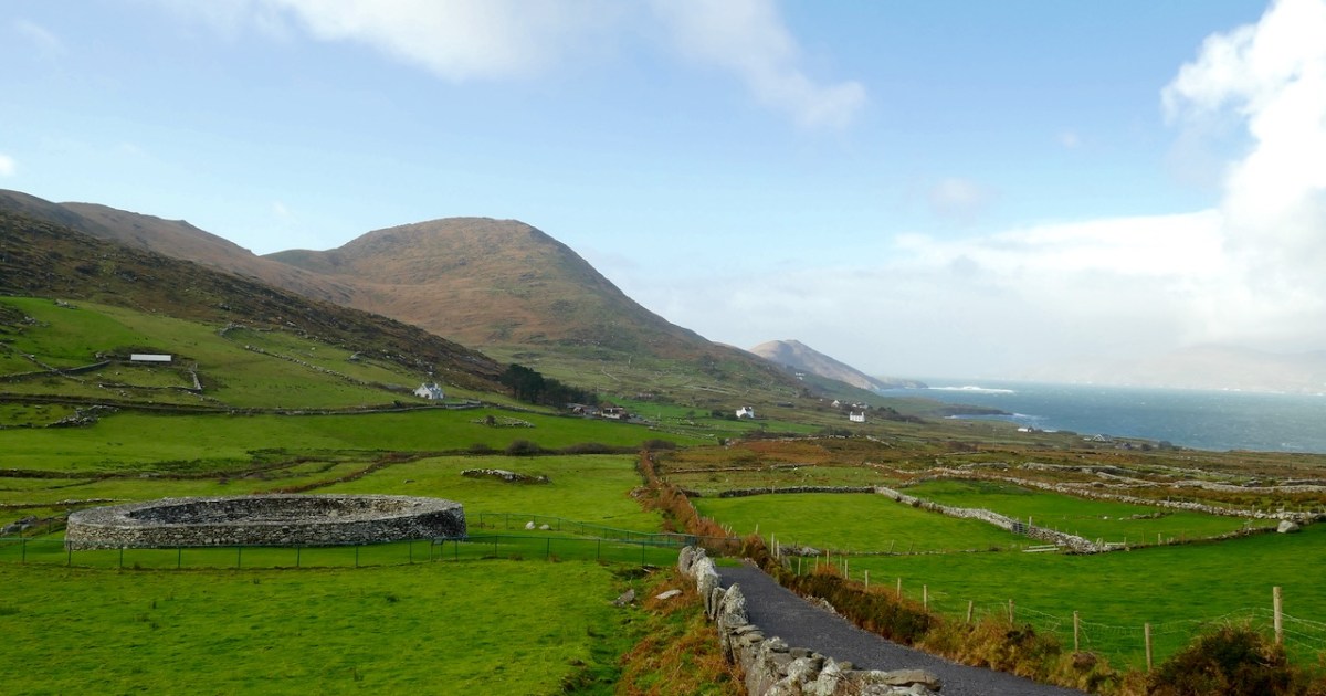
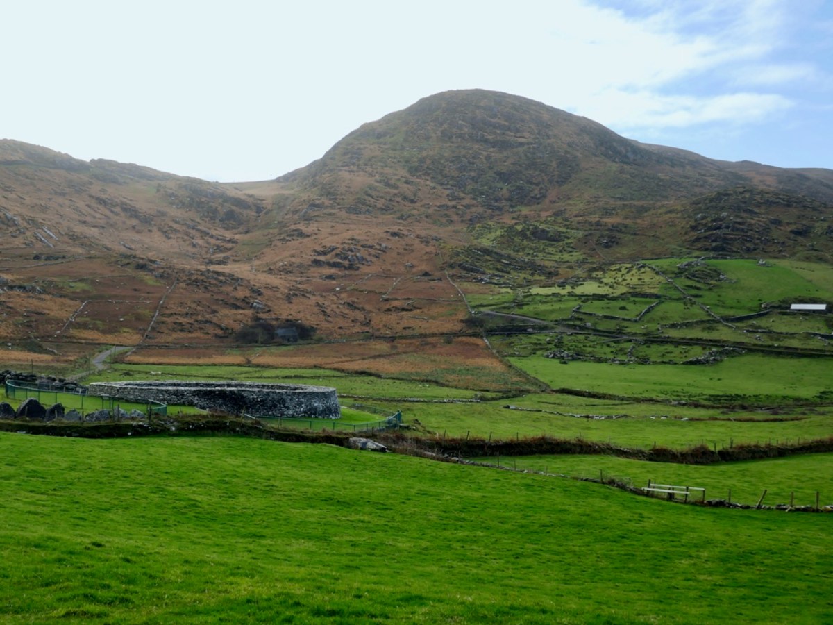
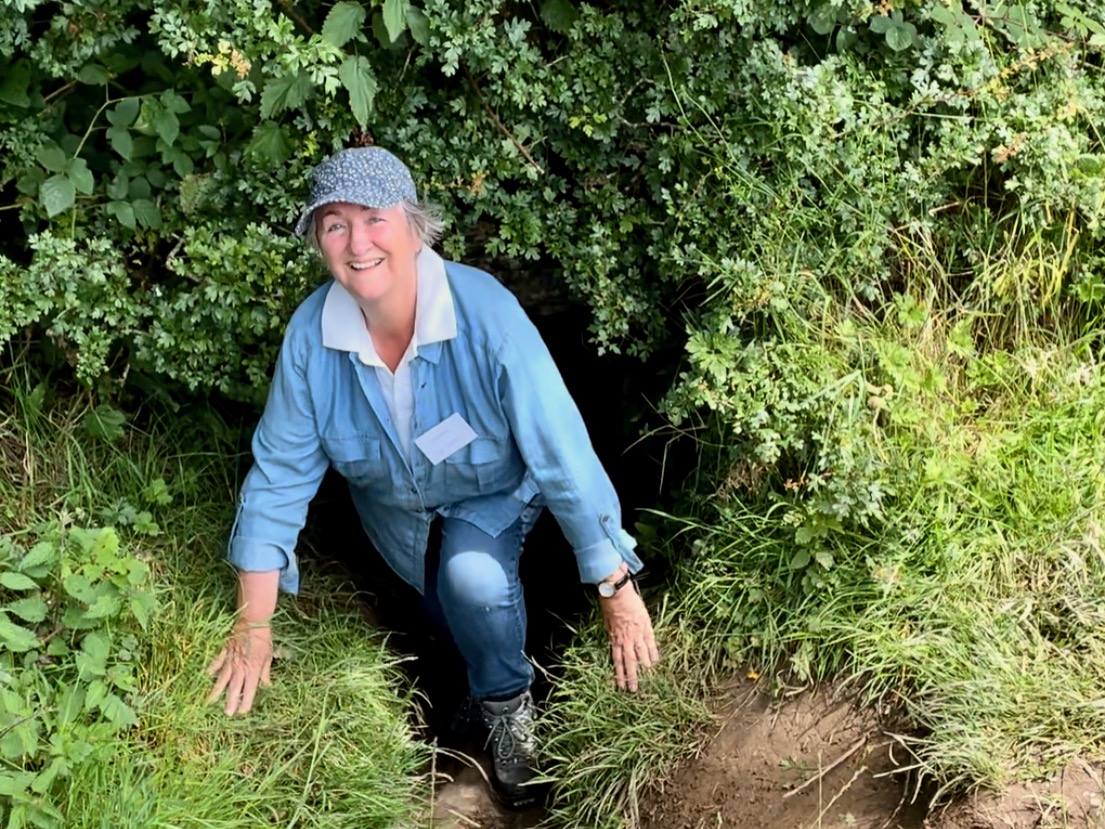
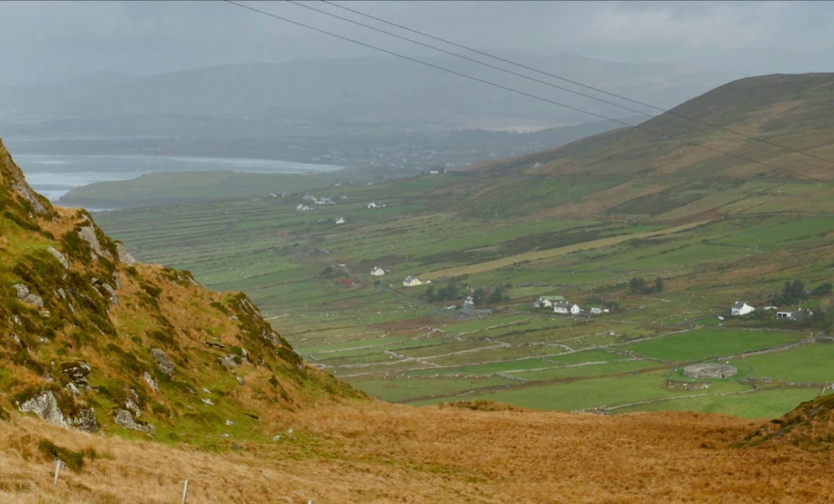
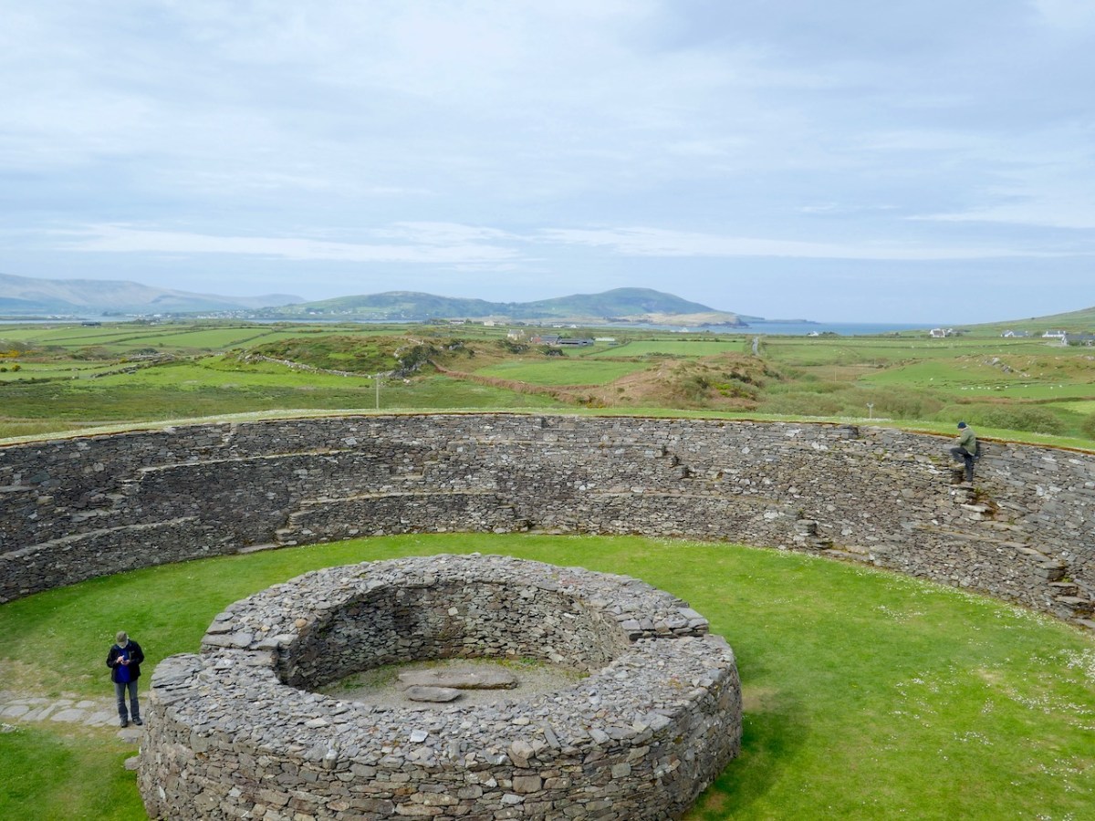
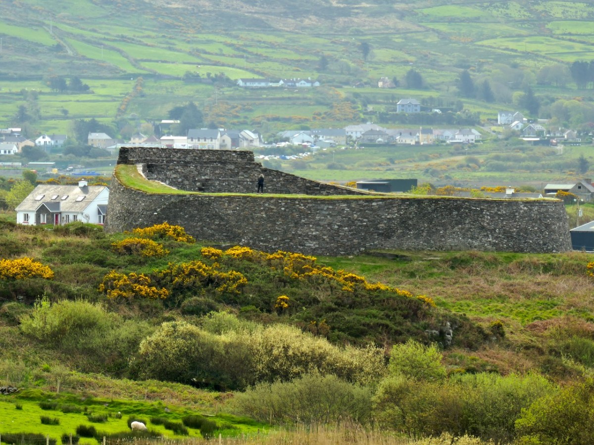
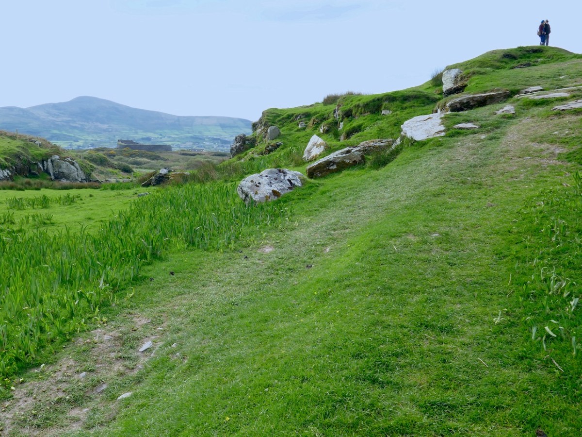
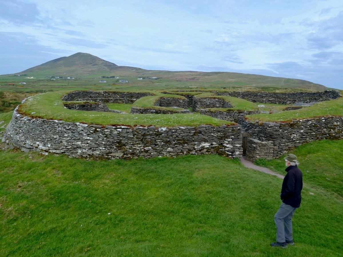
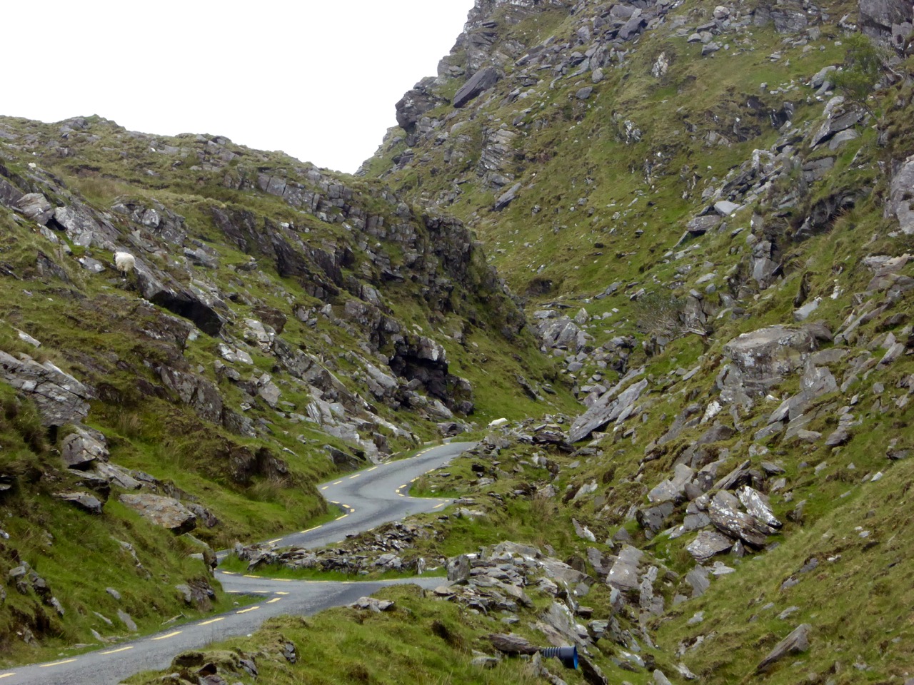
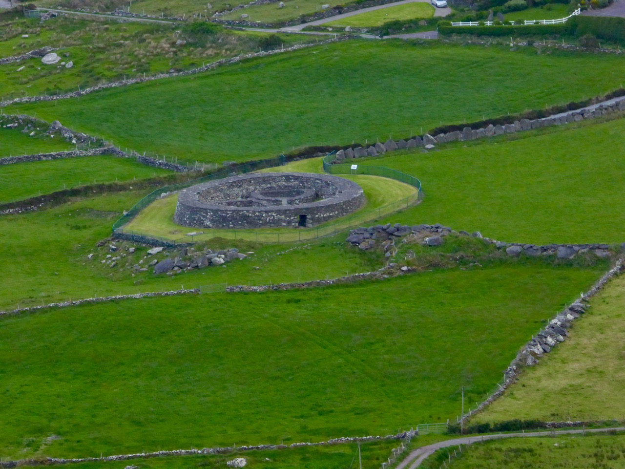
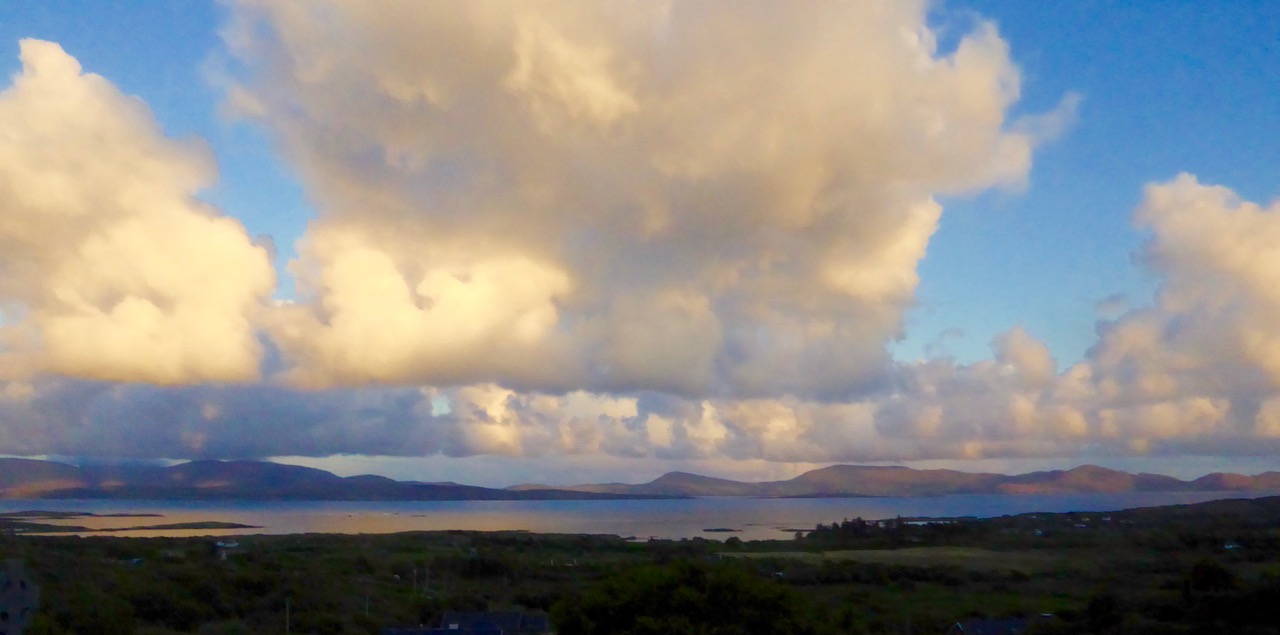
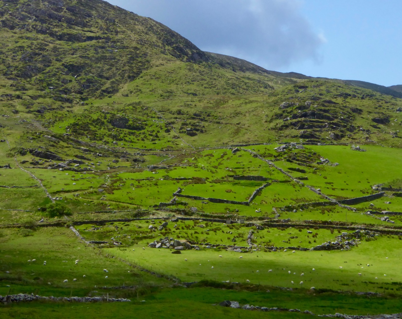
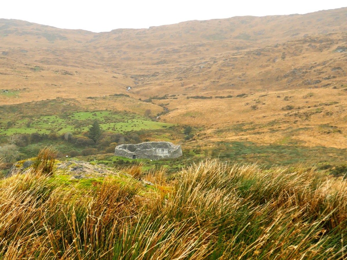
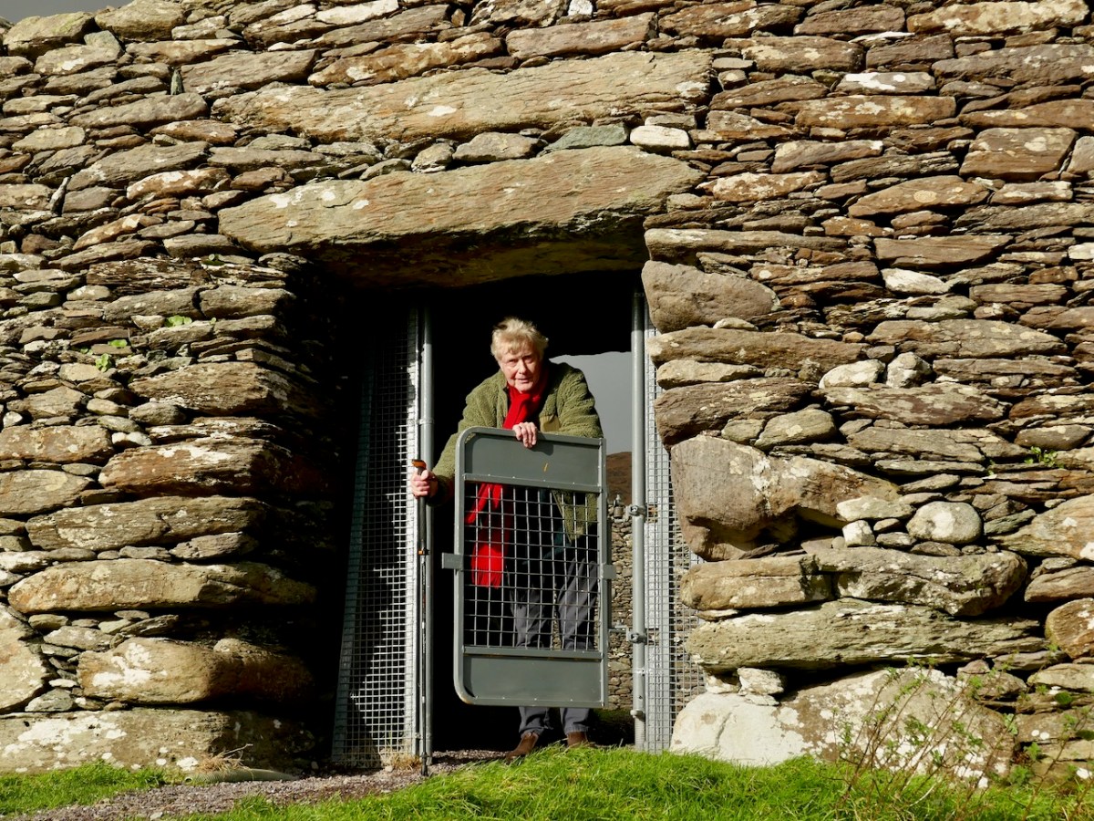
Our last, and most magnificent, cashel in this series is Staigue. Majestic, imposing and mysterious, it sits at the head of a long valley with views down to the sea, almost 4kms away.

Staigue is the one that has never been excavated, and so it is the one that we can project our own speculations on regarding its age, its function, and its association with the fairies.

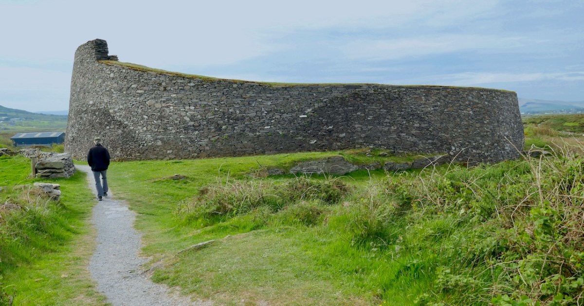
The thing that distinguishes Staigue from the other Cashels in Kerry I have written about so far is its sheer size. It’s what provokes awe. The first to write about it, in 1821, was the then-landowner F C Bland, who said:

When the appearance of the country, which is barren and uninviting, is considered, it must create surprise, what could have been the inducement to erect such a structure in such a place; and, when the  traveller, whose curiosity has supported him through a long journey, the latter part of which for ten or twelve miles has been through a wild, uncultivated, though not an uninteresting country, first approaches it, he experiences a sensation of disappointment. For it stands a single object on a hill, and from its figure (being round) producing but little effect of light and shade; and, having no familiar object by which to measure its magnitude, and its importance being rather diminished by the extent and desolation of the surrounding scenery, he attaches a meaner opinion to it than it deserves. But when he enters it, he is struck with astonishment; and his imagination almost instantly transports him to distant ages lost in remote antiquity. He vainly endeavours to figure, in his “mind’s eye,” the beings who erected it, their manners, habits, and costume; until, “lost and bewildered in the fruitless search,” his mind returns to sober investigation, again to lapse into conjecture. This effect is not lost by familiarity:—I have visited it a hundred times, and have always experienced the same sensation.

Description of a remarkable Building, on the north side of Kenmare river commonly called Staigue Fort. Transactions of the Royal Irish Academy, Vol XIV, Dublin, 1825

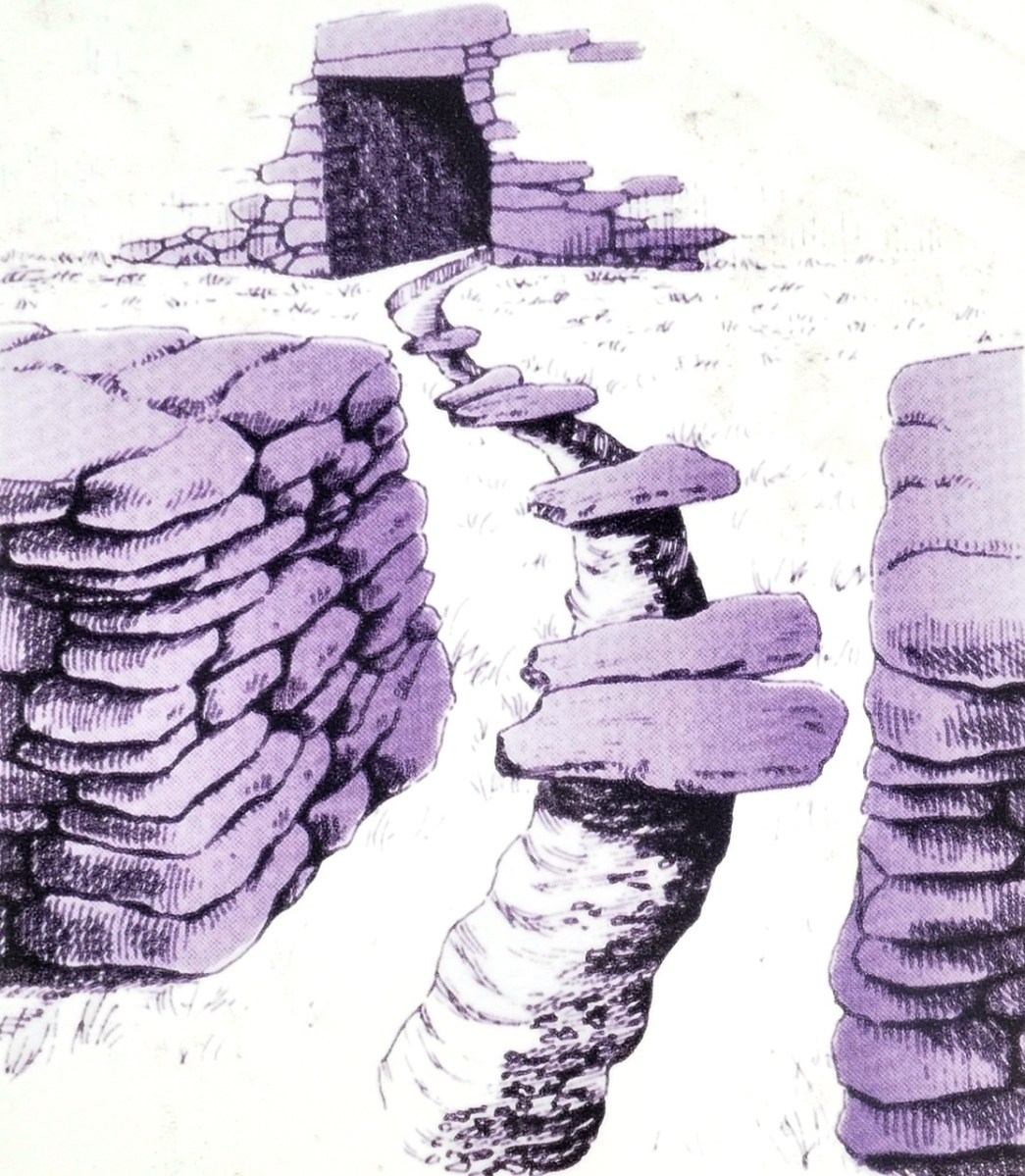
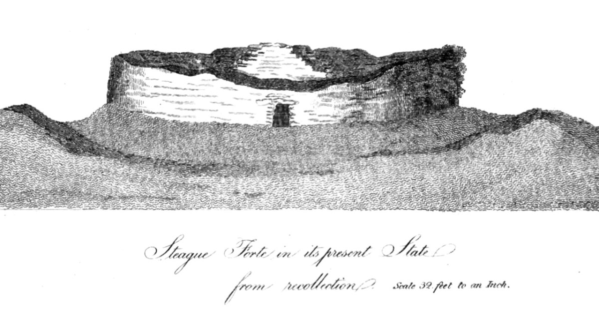
I know how he felt. Bland did a series of measurements and drawings of the fort, and they provide a charming antiquarian look at how it was 200 years ago, when it had been in use as a cattle pound. That’s one of his drawing at the head of this post. Here’s another.

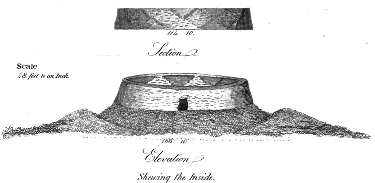
But his account is more than charming – it provides an indication of how the fort looked at that time (even though the drawings are not exactly accurate). This is important because we need to know what interventions have been made over the years to the fort – interventions that can significantly altar the profile and appearance of the fort, as we have seen in the other three. For example, he referred to an ‘eve stone’ a term that is unfamiliar to me, and said:

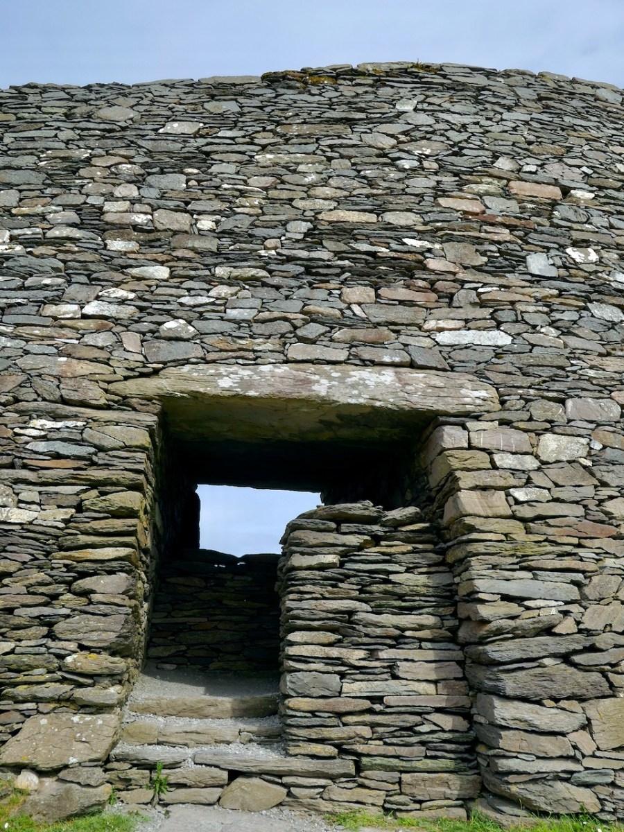
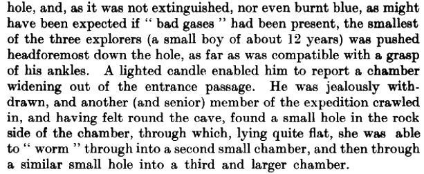
In one part, where the wall is perfect, it is surmounted  by a projecting eve stone, which, when complete, must have added greatly to the effect of the whole. This is indeed the only attempt at ornament in the entire building.

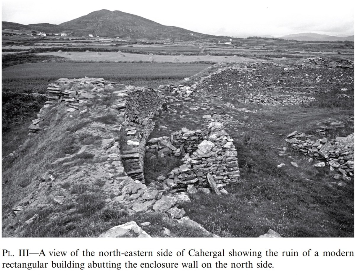
His own drawing do not show any special feature and whatever it was, no really obvious eve stone has survived the two centuries since he wrote this account. However, the National Monuments record does state The rampart stands to a maximum external height of 5.7m at N, where both Bland and Dunraven noted a number of coping stones projecting slightly over its inner wall-face (1825, 18-19; 1875, 24). Two of these remain in situ, and average 1m x .4m x .08m thick. Perhaps I need to go back and take a closer look.

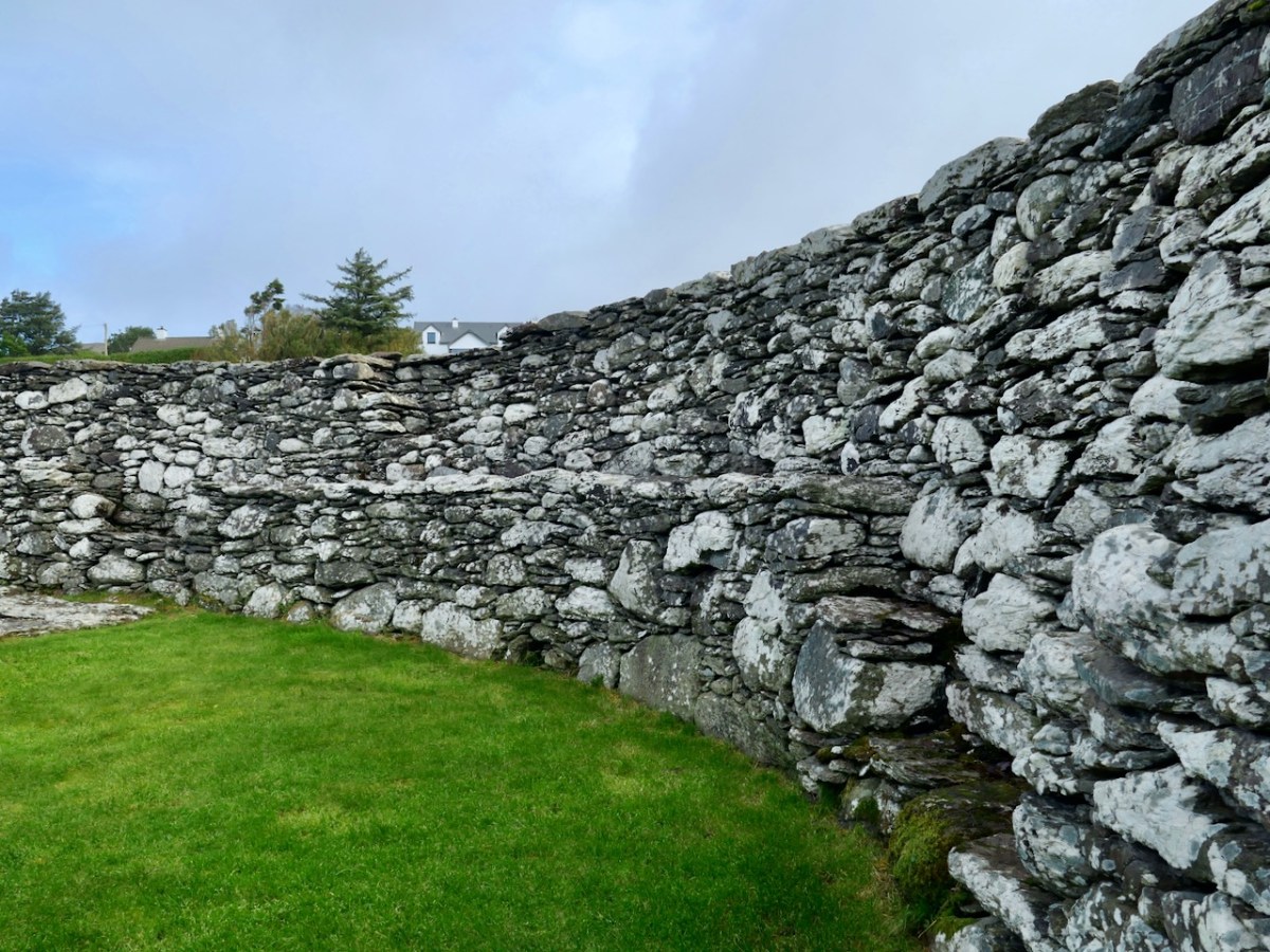
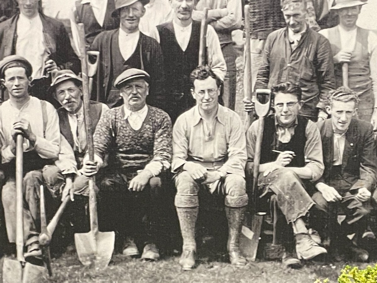
The good news is that, of all the cashels we have examined so far in this series, Staigue seems to have remained most true to its original state. That is not to say it is identical to how it was 200 years ago – it has been tidied and stabilised, although when and by whom remains uncertain. There is a suggestion that Bland himself employed local workmen to do some restoration work, and another that the OPW did some in the 19th century. 

While no records of these works remain, overall, the fort looks similar now to the older images we have of it. Historic edifices like Staigue cannot be left to crumble if significant numbers of people are visiting it. Sooner or later, as people climb on the walls, knocking off stones, it will deteriorate, creating a safety hazard and a dangerous situation for the monument itself. 

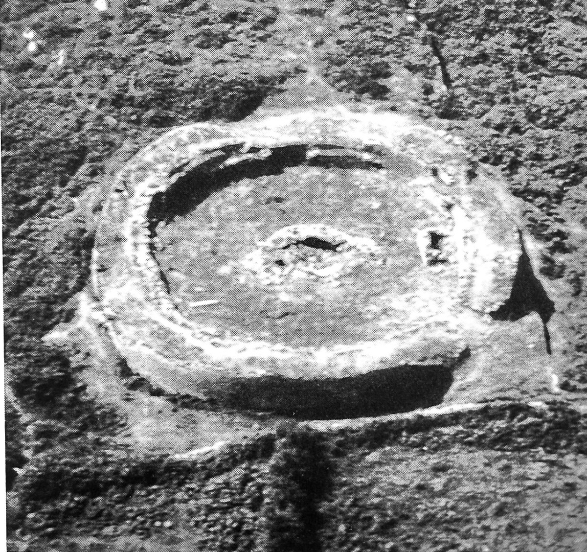
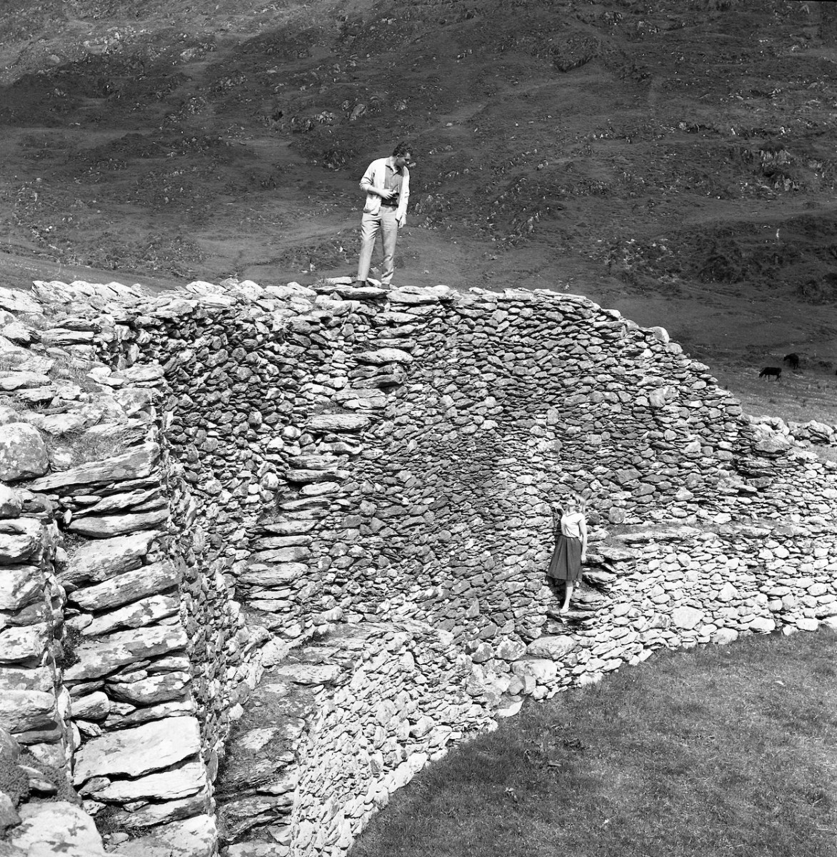
The trick is to intervene as sensitively as possible while still providing safe access and I would say that this has been done well at Staigue, although readers may want to weigh on on this question. The photos above and below are from the Irish Tourist Board collection (used in compliance with their Creative Commons License) – they amply demonstrate that climbing on the walls was as irresistible in 1964 as it is now. The ditch around the fort is also quite obvious in the aerial photo.

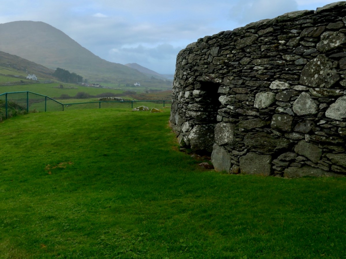
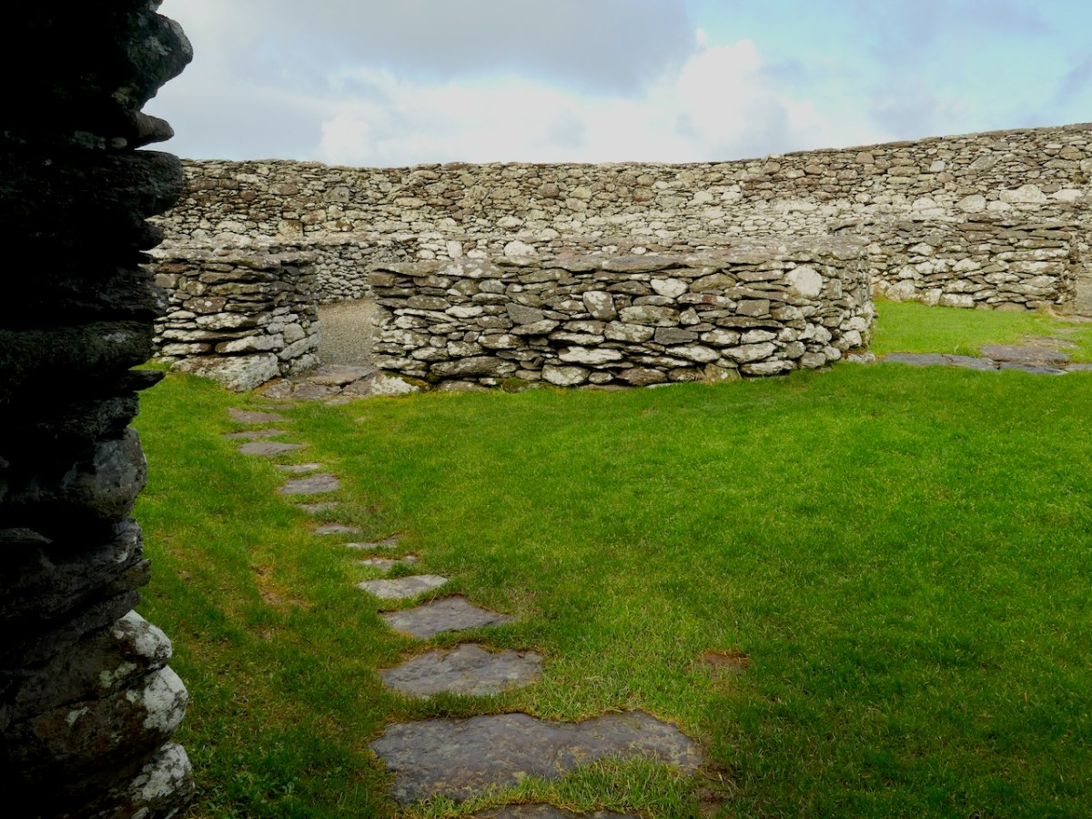
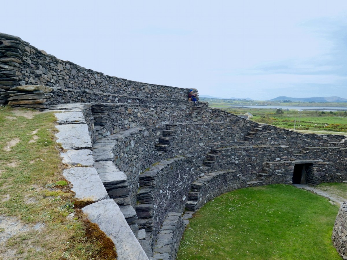
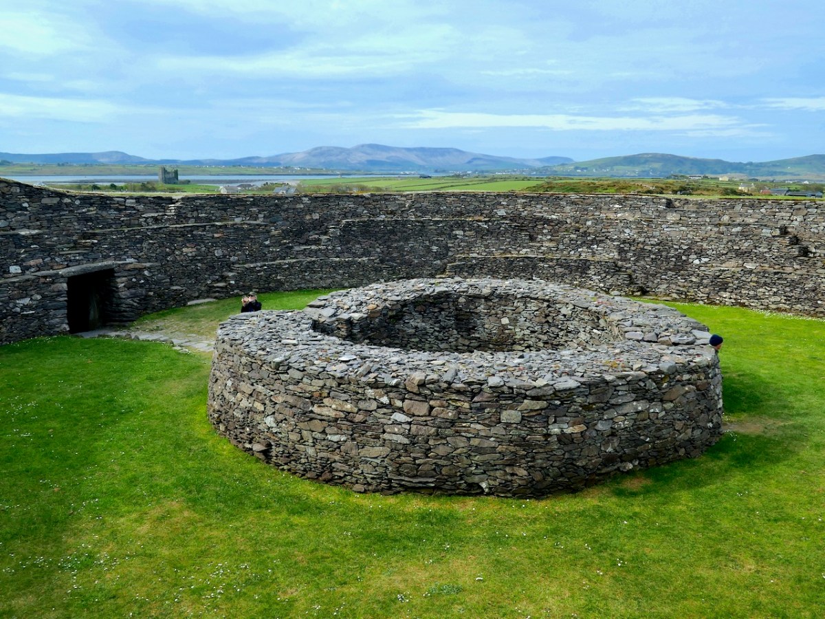
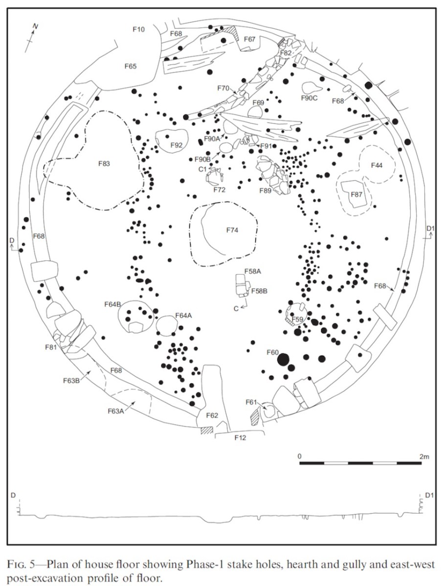
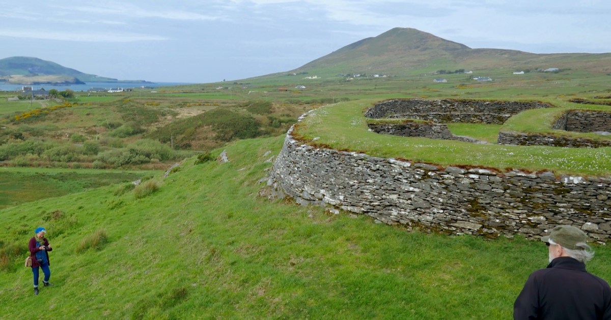
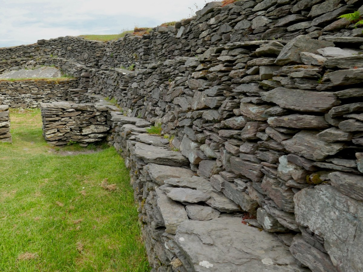
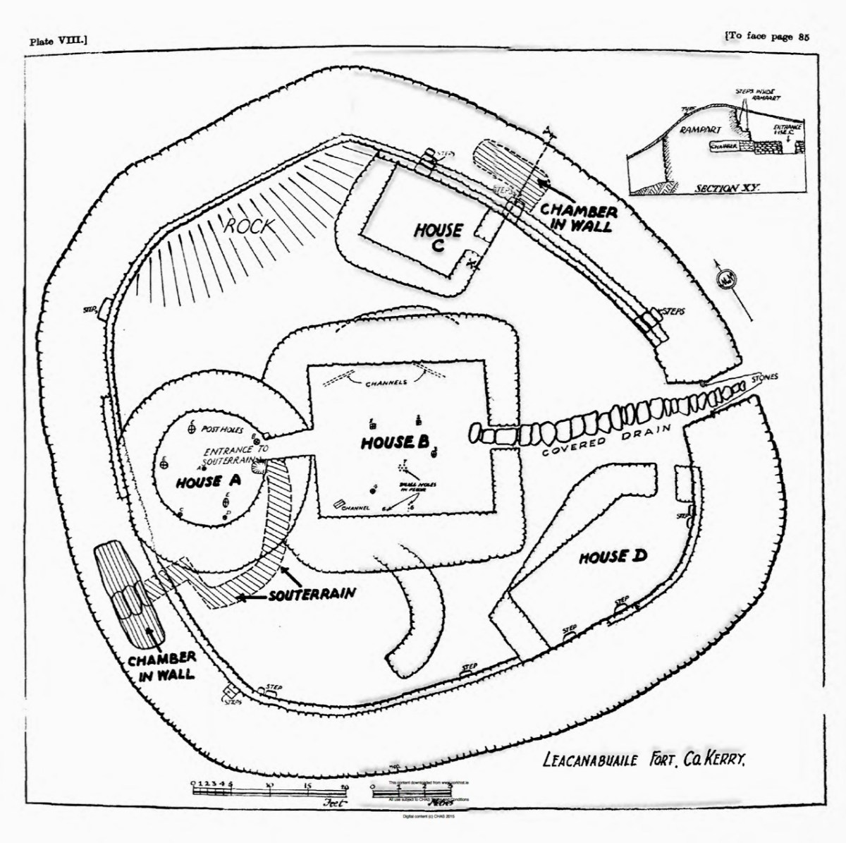
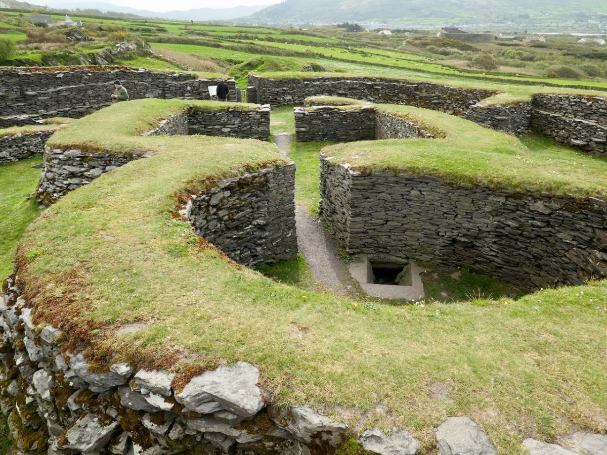
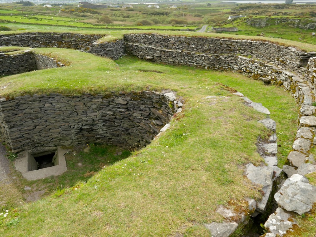
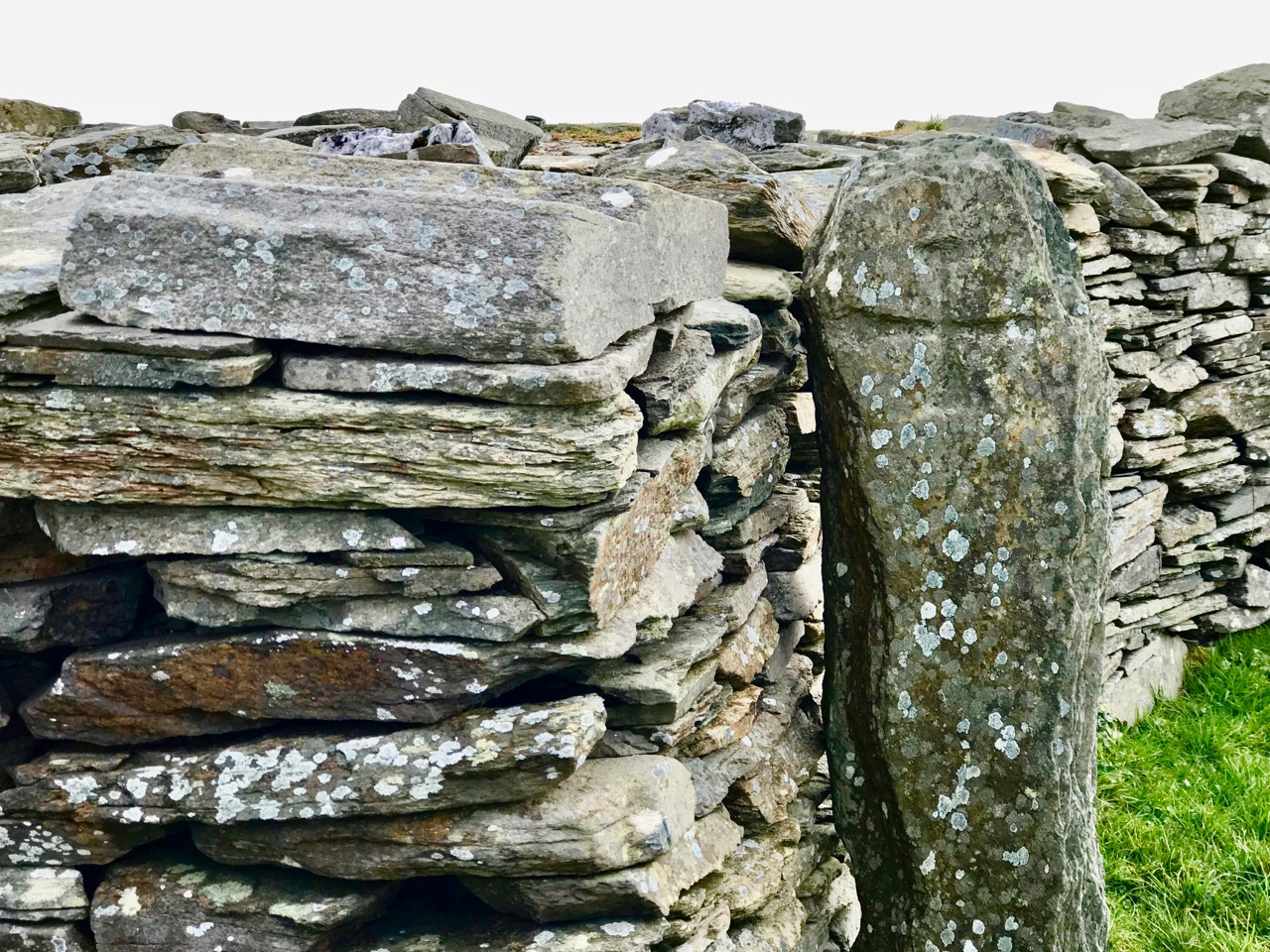
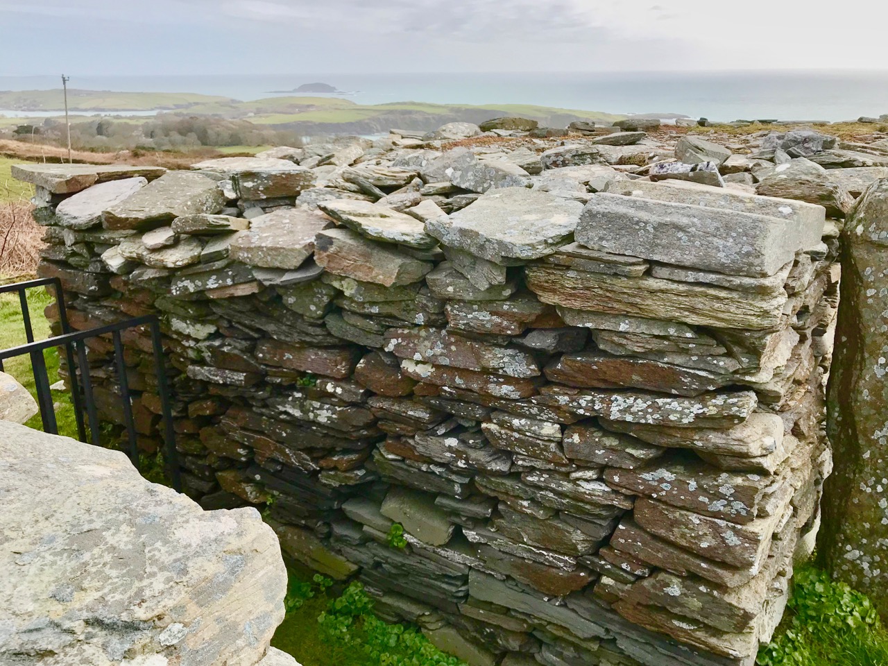
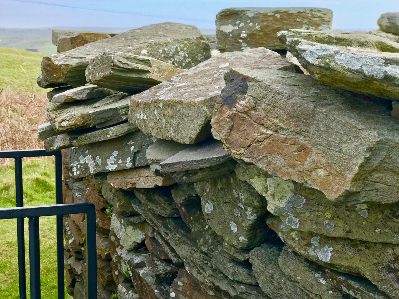
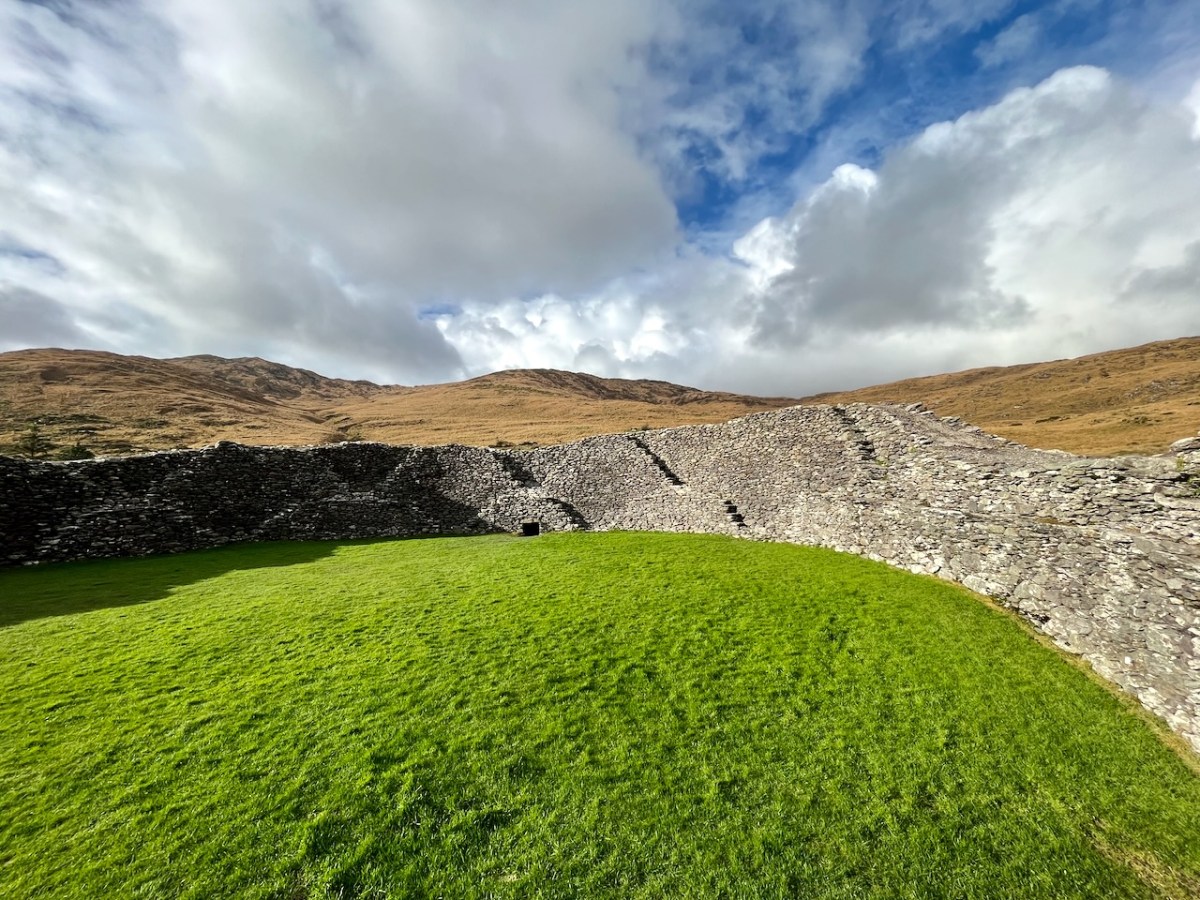
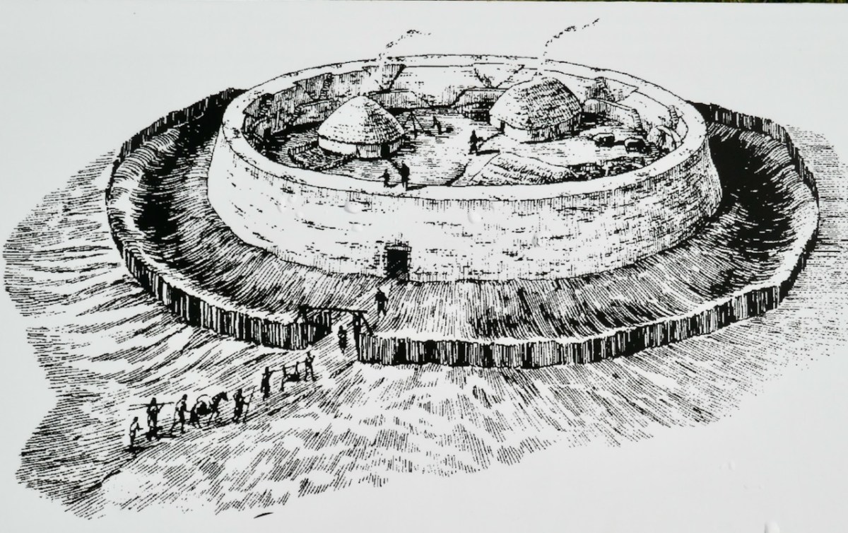
In essence, Staigue is similar to the other Cashels, with massive walls, two internal rooms or ‘cells’ in the walls, an entrance through the walls on the south side, and sets of stairs giving access to the top of the walls.

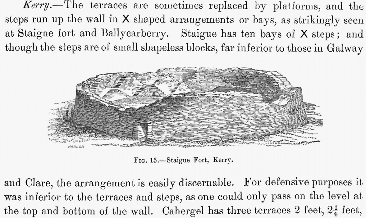
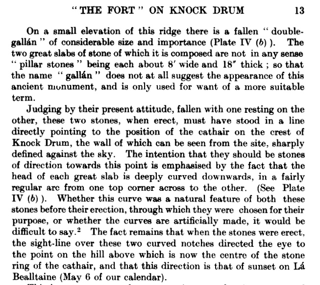
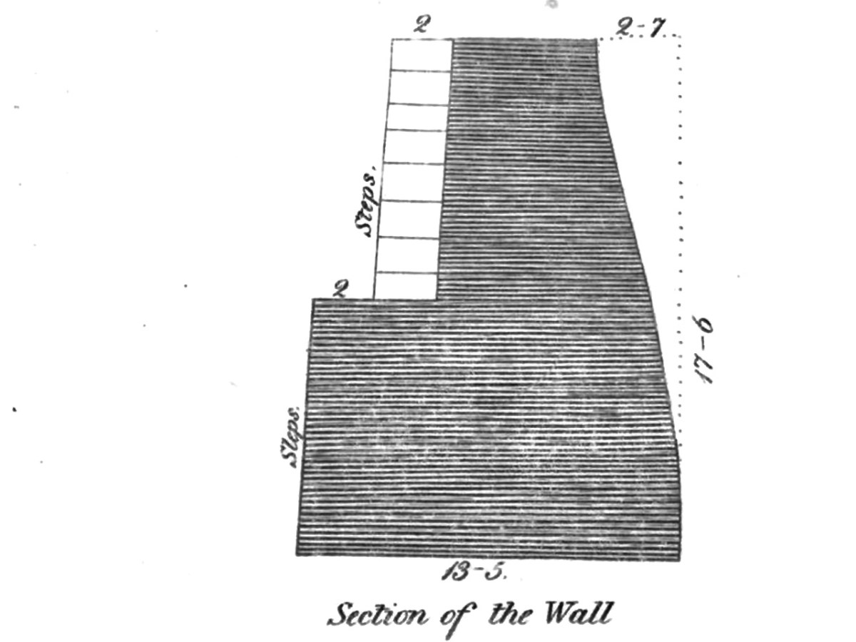
The stairs – the Irish word staighre (pronounced sty-rah) may have given the cashel its name – are the most striking feature. Commonly referred to a X-pattern, the first set lead up to a flat ‘landing’ from where the next set take off in both directions. You can see this really well in this 3D model of Staigue done by The Discovery Program. The image below is a still from the model – click here to go to it – it’s fun to manipulate it for yourself.

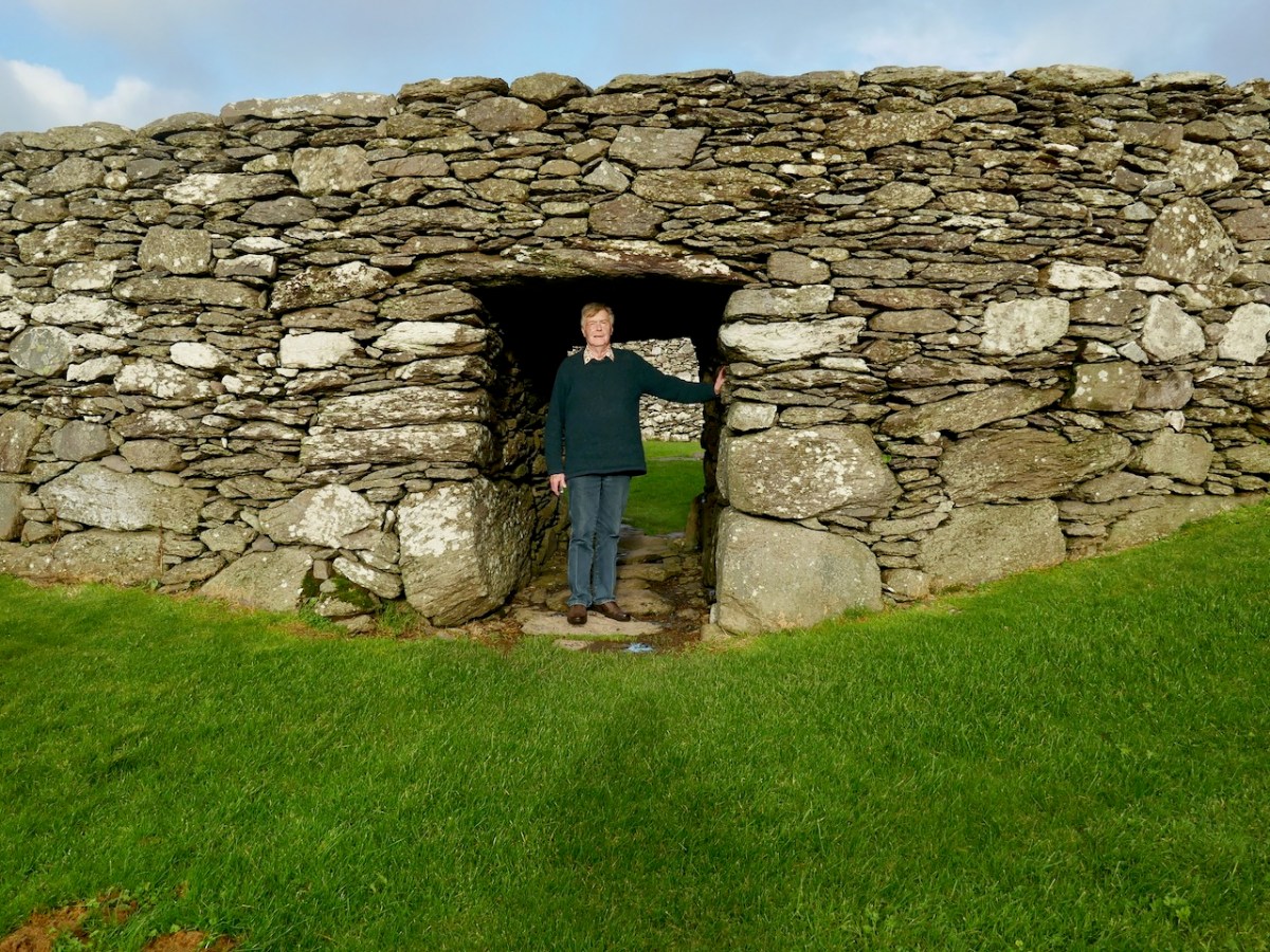
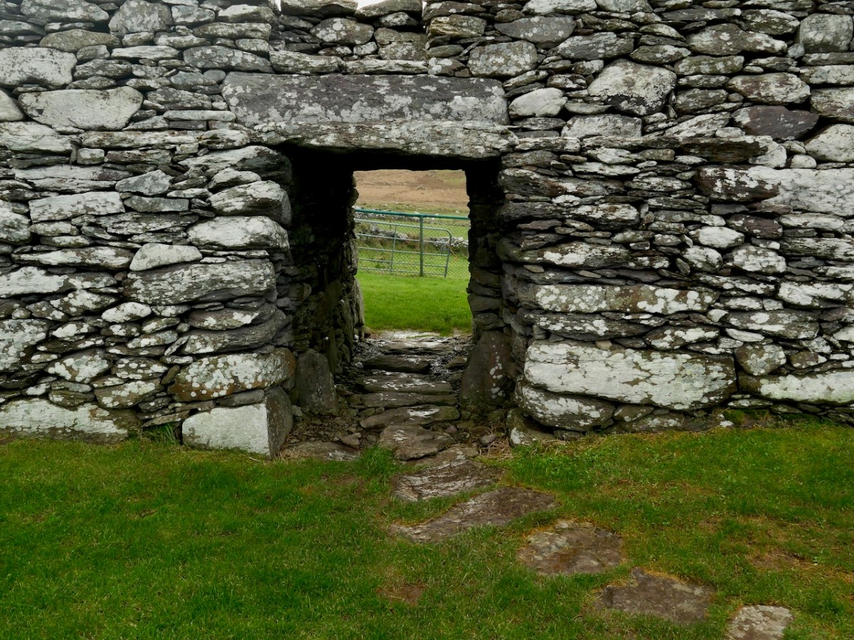
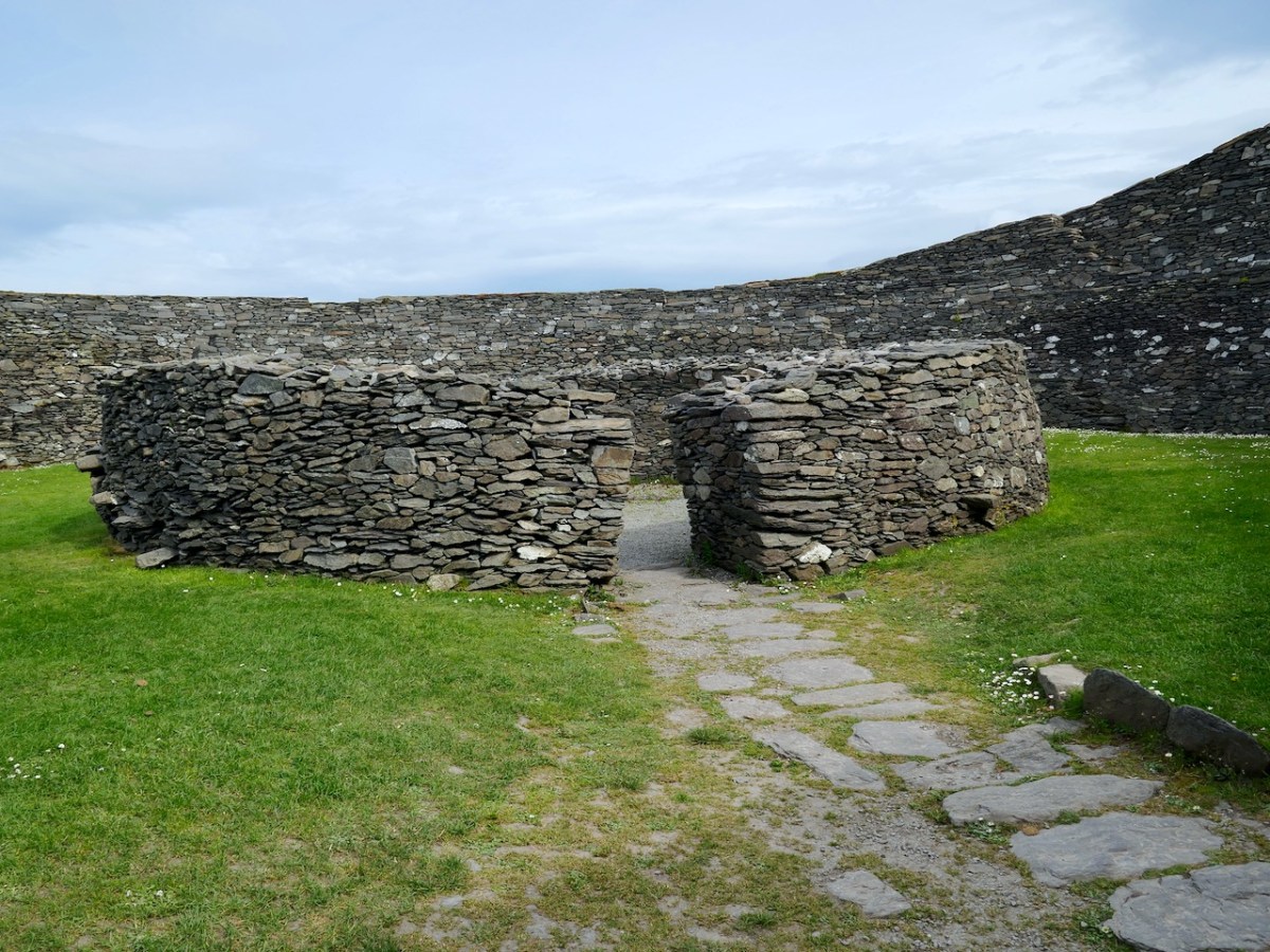
The entrance, surmounted by not one but two massive lintels, leads through the south wall, with a slightly inclined profile. The walls is lowest at this point. 

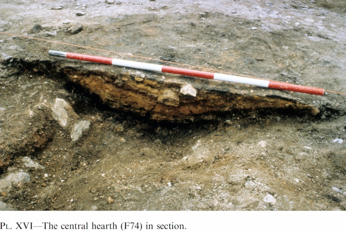
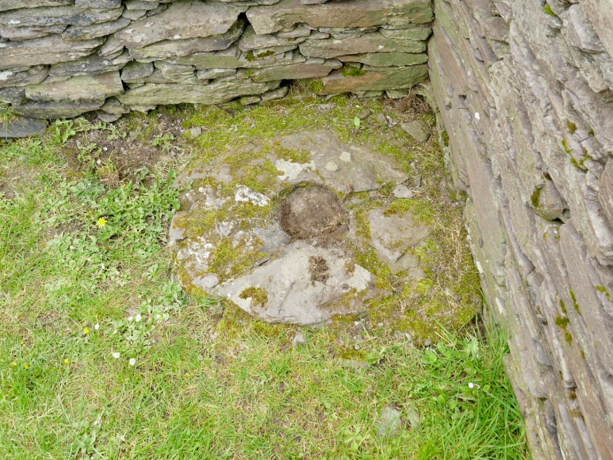
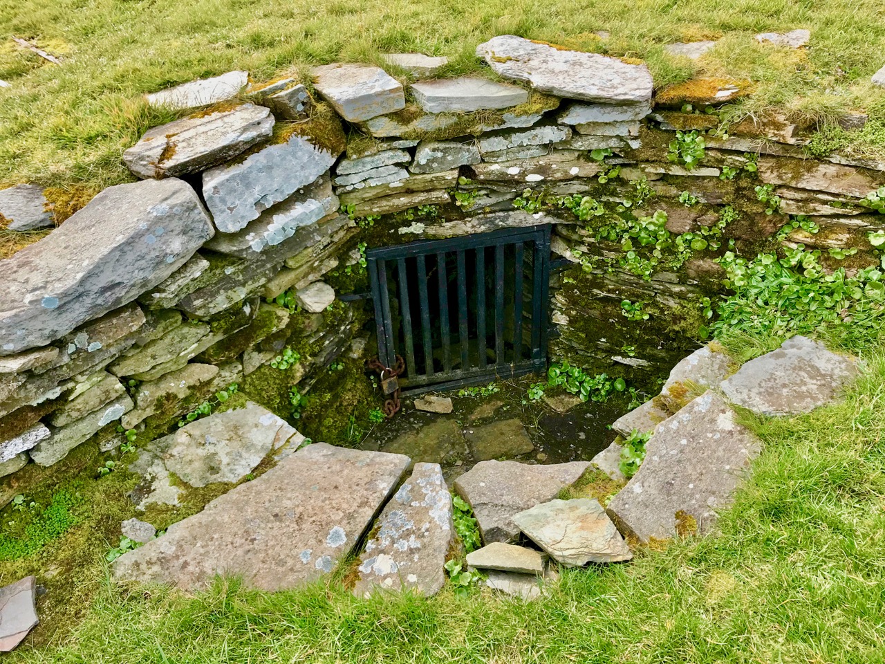
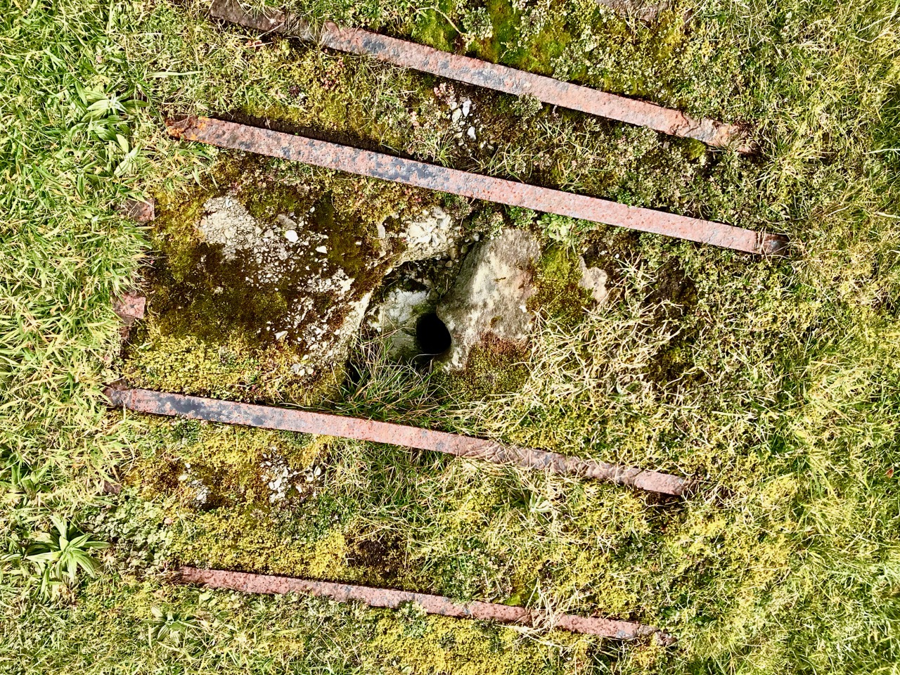
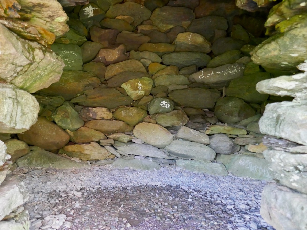
The two mural chambers are to the left of the entrance and opposite it. Their use is unclear, but they may have functioned, like souterrains, as cold storage for food.

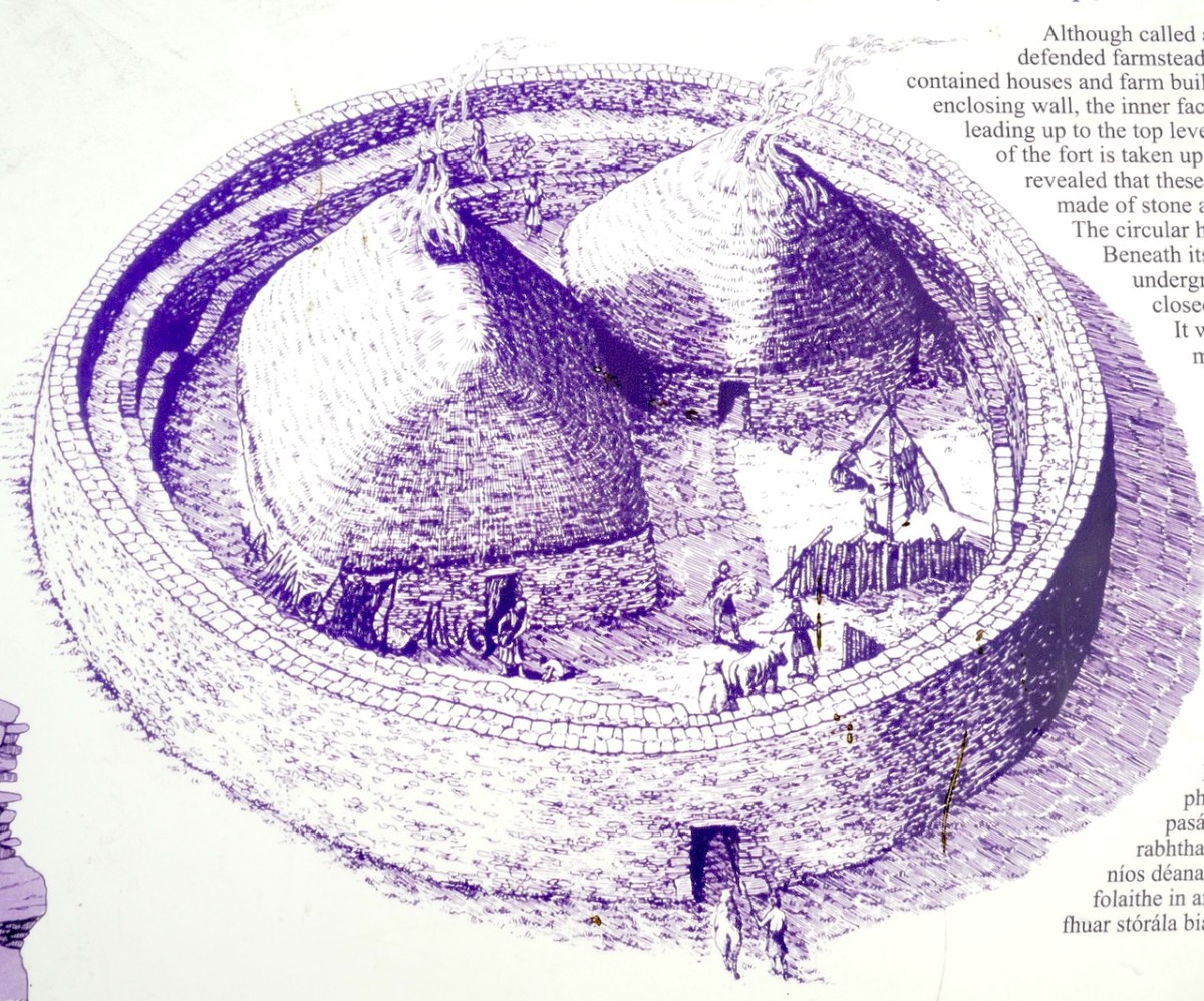
We do not know what buildings may have been inside the fort, although, as we saw in the other three, it was common for these cashels to have houses, whether for dwelling or for ceremonial use (as at Cahergal) or both. It is highly likely that any future excavation of Staigue would reveal similar constructions. The OPW sign (extract below) makes that assumption and says The fort was the home of the chieftain’s family, guards and servants, and would have been full of houses, out-buildings, and possibly tents or other temporary structures.

You remember our old friend General Vallancey from Beranger’s West Cork? In that post I told you that he was an antiquarian of the fanciful sort – forever banging on about druids and Chaldeans and coming up with far-fetched theories. In fact he pronounced Staigue to be a Phoenician amphitheatre! Perhaps Bland’s romantic illustration, below, put him in mind of such an interpretation.

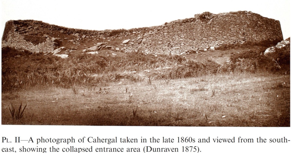
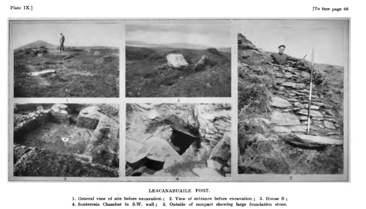
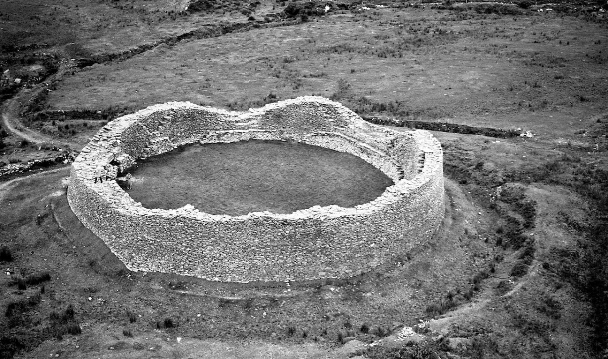
Westropp, one of whose main activities was bringing common sense to antiquarian discourse, in a series on forts written between 1896 and 1901, situated Staigue very much in line with other stone forts on the Western seaboard. The photograph below is from that series. He acknowledges the defensive nature of the huge walls, but declined to use what he saw as the simplistic term “fortress”.

As for their use as cattle pens (as Bland had suggested), he says:

It was, however, not unusual to keep the cattle in the residential fort; we find this in legend, as in the case of the cattle of Iuchna the curly-haired, and in that story, so often quoted, of the three forts of Ventry. What is stronger evidence is that the ancient laws of Ireland made provision for seizing cattle kept in forts, and even for keeping them impounded therein on dark nights. That this extended to later times we have seen in the fort-names Cahernagree, Lisnagry, &c., and perhaps even in the “pounds” of Dartmoor and the local name for Staigue fort “Pounda-na-Staigue.”


The Ancient Forts of Ireland: Being a Contribution towards Our Knowledge of Their Types, Affinities, and Structural Features. (Plates LII. to LIX.). Author(s): Thomas Johnson Westropp Source: The Transactions of the Royal Irish Academy, 1896/1901, Vol. 31 (1896/1901)

Westropp saw these forts as having multiple uses, much as Con Manning did more recently – places of assembly, of ceremony, and, if a dwelling, that of a high status individual. Indeed the command of resources it would have taken to build Staigue is staggering. The fact that it was surrounded by an outside ditch (no longer very obvious) might also add to its indentification as defensive. The photo below is from a 1950 piece by Angus Graham (Some Illustrated Notes from Kerry, in
The Journal of the Royal Society of Antiquaries of Ireland, Vol. 81, No. 2 (1951), pp. 139-145
)

We have seen that the three other Kerry Cashels have been dated to the Early Medieval and Medieval period: Leacanabuaile to the 9th and 10th centuries, Cahergal in use between the 7th and 9th centuries and again during the 11th and 14th, and Loher from 400 to 1600. It is puzzling therefore, that the OPW sign at the fort assigns a likely date of the early centuries AD before Christianity came to Ireland. In other words, the Iron Age. This assertion, of an Iron Age date, is repeated in various online sources about Staigue (including an even more vaguely worded reference to “during the Celtic Period.”). There is no evidence that Staigue was built significantly earlier than the other Kerry Cashels. In all likelihood, it belongs in the same medieval tradition of cashel-building.

If you get to Kerry, go visit all four of these remarkable testaments to our past. You will find yourself wondering at the context in which they were built, and the complex and highly stratified society in which resources could be marshalled to build something that would serve to remind all who saw it, who’s in charge here!

All four posts in this series can be found here.

Cashels in Kerry 3: Loher

I had the opportunity to visit Loher Fort in Kerry recently, so I have decided to expand this Cashels in Kerry series to four and I’m including it in the list. I’m leaving Staigue till last.

Loher Fort was excavated for four seasons in the 1980s by an archaeologist from UCC. Yes, that’s right, four seasons! You might reasonably expect, therefore that this would be the fort that would yield a thick report full of details and illustrations of what was found, some radiocarbon dates, some historical context – but shockingly, the only report ever forthcoming was a few paragraphs provided to Excavations.ie. I quote it in full now.

The fourth season of excavation was completed during 1985. The site may be classed as a cashel, 20m in internal diameter, with rampart walls, 2m thick.

Prior to excavation the interior of the site was composed of stone fill to a depth of 2m. On removing this fill, 2 stone structures were uncovered. Both of these had walls surviving to a height of 1m and 1m in thickness. One structure is circular (clochan type) and the other rectangular. The circular structure is c. 5m in diameter and the rectangular structure is 7m x 6m in extent.

The interiors of both these structures have been excavated. This revealed no great depth of occupation deposit but did reveal a good stratigraphic sequence of structures. Essentially, there are 5 identifiable structures including the above two. In the area of the surviving circular structure, an earlier stone-built circular structure was uncovered. This was pre-dated by a wooden structure constructed of driven stakes.

The rectangular structure was pre-dated by a circular wooden house, again of driven stakes. There is also the possibility of another post-built structure in this area. Apart from the above mentioned stratigraphic relationships, the latest circular structure pre-dates the rectangular stone structure. Other features include a souterrain associated with the circular house, and a parapet walkway and mural steps.

Finds include glass beads and a tanged knife. Organic material includes shell, carbonised seed remains, fish scales and fish bones.

https://excavations.ie/report/1985/Kerry/0000602/

That’s it – that’s all we know, apart from a very broad assigned date in the overview of Medieval (AD 400-AD 1600)

Interestingly archaeologist Aoibheann Lambe, the rock art expert, has identified a number of pieces of rock art in an around the fort, including on stones used as building materials. While these pre-date for fort by several thousand years, it is evidence that people were living in this area for millennia. It’s easy to see why – it’s a spectacular setting, with access to the sea and a location that provides a strategic point of domination over the surrounding landscape.

As at Leacanabuaile, there was also a souterrain, although there is no indication on the ground now of where it was, and we have no record of what it looked like and no plan. It was under the round house, which is the earlier of the two houses. Here’s what the National Monuments records says about that:

The entrance to a souterrain is located in the W half of the interior of the house. Measuring 1.1m x 1.3m, it gives access to a drystone-built lintelled passage, 1m high, which runs E-W for 3m before turning sharply to N. The excavation revealed that the construction of the souterrain post-dated that of the house, and that an earlier stone-built circular structure in the area of the house was, in turn, pre-dated by a wooden structure constructed of driven stakes.*

What is a souterrain exactly? As the name suggests, it’s a man-made underground passage, often associated with ringforts and cashels. They may have had a variety of uses, but perhaps the main one was as a root cellar to preserve food. That’s me, above emerging from one of the most famous of of our Irish souterrains, Oweynagat at Rathcroghan. They’re a common class of archaeological monument – there are over 1,000 in Cork and over 800 in Kerry. Folklore is rich with stories of souterrains that stretch for miles, that end up in the sea or in a nearby castle, but alas although we know of complex examples with passages leading to multiple chambers, most are quite short and contained within the general area of the ringfort. For more on souterrains, see this wonderful site. 

There was also a covered drain leading from the fort entrance to the house, and another between the two houses. Not quite the fine paving that was found at Cahergal, but certainly a way of keeping your feet dry on what were no doubt well-worn paths. There’s no mention of this in the brief report, but obviously the OPW, who conducted the reconstruction, knew about this, as did National Monuments who commissioned the interpretive plaque. Is there, in fact, more information available somewhere? I would be happy to stand corrected.

The walls and stone steps, which are a standout feature of these Kerry Cashels, are described in the National Monuments record. Note they use the word Caher instead of Cashel – both mean ‘stone fort.’

Caher Wall: This consists of a rubble core faced internally and externally with random courses of well-built drystone masonry. Much of the external face, which is battered, is concealed by a substantial build-up of collapse and field-clearance material. The wall, which is up to 4m in basal thickness, varies in external height from 1m to 2.5m and internally from 2.5m to 3.3m. A lintel-covered paved entrance passage. . . leads into the interior of the site from SSE. A terrace, reached by means of seven inset arrangements of opposing steps, occurs on the internal face of the caher wall at an average height of 1.3m. The arrangements of steps occur at irregularly spaced intervals, and the individual sections of the terrace to which they give access average .6m wide. Traces of a short section of a second terrace, also furnished with steps, occur above the first in the N sector of the wall.*

Because we have no access to a proper excavation report, we don’t know how closely the reconstruction efforts at Loher were based on the findings. However, from the little information we have it seems that what we see now on the ground is a reflection of what was left after multiple periods of occupation, one of which (perhaps the earliest phase) included a house built with wooden stakes. 

Like Leacanabuaile and Cahergal, it seems that once the excavation is over, the OPW moves in and ensures that what is left, if it is to be open to the public is made safe for visitors. If that was all they did, we might all, perhaps, be a little less confused now about what these forts looked like originally. But the instinct to reconstruct is strong, as well as the perceived need to tidy up the place, round off sharp corners and keep the grass trimmed to golf course standards. The information plaques the National Monuments folk provide are exceptionally well designed and full of welcome information.

What we can say is that it’s a wonderful site, impressively built and situated, and adds to the sum total of what knowledge we have of how high-status individuals constructed statement dwellings or ceremonial spaces for themselves in medieval Ireland. 

  • The description is taken from the online inventory maintained by National Monument for all archaeology sites in Ireland, available to search here:

All four posts in this series can be found here.

Cashels in Kerry 2: Cahergal

Cahergal is undoubtedly one of the finest examples of a stone ringfort or cashel in Ireland. What makes it outstanding is not the overall size of the enclosure or the height of the enclosing wall but the quality of the drystone masonry, the width of the entrance, the thickness of the wall and the well-planned and executed almost symmetrical stairs and terraces on the inner side of the wall.


Excavations at Cahergal, Co. Kerry:
A Venue for Royal Ceremony in Early Medieval Corcu Duibne

All quotes in this post are from the 2016 excavation report by Conleth Manning of National Monuments*. Con’s report deals with the 1986 brief excavation near the entrance, and his own 1990-1991 excavations inside the cashel. The excavations established a date for the fort – it was originally built between the mid 7th and the mid-9th centuries – as well as providing evidence for its status and uses. It also established the basis upon which most of the restoration work was done – although note I say ‘most.’ In the photo above you can clearly see the old and newer stonework.

Like Leacanabuaile, this was a rather tumbledown ruin before excavation and restoration projects. All that incredible masonry work did not save it from the ravages of time, although the exceptionally high standards of building became clear as it was dug out from the jumbles of stone and grass that covered it.

The initial stages of building included the walls, with its staircases, the entry passageway and the fine paving, as well as the round house in the interior.

The stairs and terraces on the inside of the walls are one of the striking features of this fort. There are two levels of terraces along most of its length, but in one area the stairs went up to three flights. The excavation report states, The third set of steps probably led to a wider viewing terrace, which was likely to have been flanked externally by a parapet wall.

After the excavations the OPW continued to work on the restoration of the fort and this finding was interpreted to mean that this section of the walls was much higher than other sections. This led to a decision to raise the top of the wall in this section, leading to the somewhat startling profile we see now. According to Con Manning this is a skewed interpretation by the OPW and it is highly unlikely that it reflects what the wall actually looked like.

The entrance to the fort had completely collapsed but excavation revealed how deep it had been. A pair of upright jamb stones and fallen lintels were found, leading to the reconstruction as we see it today.

The house was circular and the amount of fallen stone inside led to the conclusion that the roof was originally made of stone, probably using a corbeling technique. If this was the case, this house is the largest round building known to support a stone roof, well known from church sites (such as Kilmalkeader) where the stone roofs are rectangular and steeply pitched. 

A very finely laid-down pavement led from the fort entrance to the door of the house. The pavement was delineated at the side by edge-on kerb stones.  The house originally had three doors, with the main one positioned across from the entrance to the fort, and accessed by walking along the pavement.

Internally, there was a central fireplace (Feature F74 in the pan below). Stake holes around this central feature were probably to support a beam or spits for cooking purposes. The fireplace itself showed that numerous fires had been burned in it. Other stake holes supported furniture for sitting or sleeping.

The strange thing about Cahergal is that the excavations yielded very few finds (compared to Leacanabuaile, for example) and what was found mainly dated to later periods of occupation. So – what was going on during the original period of occupation – mid 7th to mid 9th centuries? Manning speculates that this was actually a royal site, built to impress, to inspire awe, and perhaps to entertain. Ritual feasting would take place in the main house, which would be cleaned carefully afterwards and readied for the next great occasion.

The three doors might support its interpretation as a royal site. Manning says:

In each case the side entrance might have been for people of lower status, with the main entrance being reserved for kings, nobles and important guests. On the other hand one could regard the three doorways as symbolic, three being a magical number as in the triads, and in this case could symbolise the three divisions of Corcu Duibne. In the tale of Branwen daughter of Llyr, in the medieval Welsh Mabinogion, a royal hall with three doors is mentioned in the house of Gwales (Grassholm), where one door, facing Cornwall, was kept permanently closed with a taboo on opening it.

This interpretation of the function of the fort and house – designed to impress and to underscore the prestige of the builders – reflects the later castle-building of Irish chieftains. Here in Ivaha, for example, the O’Mahony clan built tall, overpowering castles to cement their control over the land and the sea around them. Cahergal is within sight of two other cashels – the Castles of Ivaha were often within sight of each other too. Annals tells us that the Taoiseach of the O’Mahony clan built a castle for each of his sons, or other members of his ‘derbfine’ – the family group from which the chief was chosen. 

As if to confirm this possibility, Ballycarbery Castle, a 15th century tower house, lies within clear sight towards the coast. Was this a continuation of the same tradition by the same family – the Falveys? Manning concludes his report by stating:

This [high-status] phase ended with a burning of the internal features and subsequent, probably occasional, lower-status use of the house between the eleventh and fourteenth centuries. Iron forging took place here in the fourteenth century. After the eastern half of the stone roof collapsed and the structure was abandoned for some time, it was roughly rebuilt as a D-shaped structure probably in the fifteenth century.

The last period of occupation was the modern period – the small building built against the wall in the photograph below was probably a sheep-pen noted by an antiquarian visitor.

The final fort we will talk about is Staigue – in many ways it’s the most spectacular (despite not being as well built as Cahergal) but it has not been excavated so less is actually known about it. Meanwhile, if you can’t get to Cahergal but want a Cahergal experience, visit the marvellous Voices from the Dawn – Howard works his 3D magic on this page.

*Conleth Manning. Excavations at Cahergal, Co. Kerry: A Venue for Royal Ceremony in Early Medieval Corcu Duibne. Proceedings of the Royal Irish Academy: 2016, Vol. 116C

All four posts in this series can be found here.

Cashels in Kerry 1: Leacanabuaile

We have been in Kerry a few times this year and visited three stunning sites – Staigue (above), Leacanabuaille and Cahergal (sometimes written Cahergall) – all of which fit the definition of stone forts, often referred to as Cashels. For non-Irish readers, cashel is pronounced the same way as castle, but with the sh sound in the middle –  don’t say cash-elle. 

Each of these also fit in to a category that has been labelled by archaeologists as the Western Stone Forts, and they were the subject of research by the Discovery Program several years ago. The forts included under this title, about 25 in all, dotted along the western seaboard, were chosen because of their their large size, or prominent location or because they have complex or massive defensive features.

In a fascinating talk available to view online, archaeologist Claire Cotter walks us through several examples of such forts. In relation to size, she points out the huge investment in effort to build those walls, once you go over about 2 metres in height. Of course the walls have to be very thick as well, to carry the weight of all that rock and to ensure they didn’t fall over. Inside, a feature of Staigue and Cahergal are the stone staircases arranged in a X shape – they make for a strong visual statement. Leacanabuaile (below) has stepped levels on the inside of the walls to give access to the parapet. Let’s take a look at each fort in turn to see what’s unique and what’s common among the three of them. 

We’ll start with Leacanabuaile, pronounced Lacka – na – boolya and meaning the flagstones of the enclosure, or possibly the flagstones of the summer pasture. Large flagstones, or leacs, do litter the way up to the fort.

Leacanabuaile was excavated in the summers of 1939 and 1940 by Sean P Ó Ríordáin and J B Foy. Ó Ríordáin was a revered Irish archaeologist and his book, Antiquities of the Irish Countryisde was our text for first year in the Archaeology Department at UCC, where he had been the professor before O Kelly. That’s Ó Ríordáin in the middle, below at the Lough Gur dig in Limerick, with O Kelly furthest to his left. As an aside, he was married to Gabriel Hayes, the sculptor – one of her major works is mentioned in this post. She did the drawings of the finds, which you will see further down.

For most of the following, and all the quotes, I am taking the information from the excavation report, which was published in the Journal of the Cork Historical and Archaeological Society for 1941. The marvellous CHAS has made their old journal available online, and this report is here. Leacanabuaile is situated in the middle of a concentration of forts, close to Caherciveen and all within a  mile or two of each other, and in the case of Cahergal, in clear sight, as you can see below.

Before the excavation it was in very poor condition – the walls had collapsed and it looked more like an earthen ringfort, with just traces of the stone wall showing through here and there. It was so unremarkable, in fact, that it was left off the Ordnance Survey maps. 

The excavation uncovered not only the massive nature of the walls, but four houses inside, a souterrain, and mural chambers. This was before the commonplace use of radiocarbon dating in Ireland so the usual way of dating a site like this was through the finds and through comparison with similar sites. Using these methods, Ó Ríordáin says:

 The close dating of the Leacanabuaile site is not possible, but it may be noted that the finds correspond to material from sites dated by more significant objects to the ninth and tenth centuries AD.

The fort is not quite round and this was due to the undulation of the rocky hilltop on which it was built, the builders having to work around the steep slopes. The souterrain and the mural chambers were built at the same time as the walls. 

Of the houses inside the fort, three were built at the same time as the fort – round house A and two others which now lie under house B. Houses D and C were the last to be built.

In regards to the material cultural objects found during the excavations, and what they reveal about the inhabitants, Ó Ríordáin states

Elaborate brooches and glass objects, for instance are notable by their absence. Bronze is rare and there is no evidence of its having been worked on the site – crucibles are not forthcoming: iron working is evidenced by the iron slag found. On the other hand, the inhabitants were probably quite well provided with the more vital necessities of life. They had . . . a dual source of supply – the sea and the land. The plough-sock and the querns show show that grain was cultivated, the bones show that domestic animals were kept and eaten, while the fare was added to by the collection of shellfish from the coast and by the capture of birds, particularly sea-birds.

The sea birds included heron, duck, goose, cormorant, puffin and razorbill, while the domestic animals were ox (most numerous), sheep, and pig. Also found were evidence of horse, dog and red deer.

What we see on the ground today is the result of conservation work undertaken by National Monuments as Leacanabuaile was taken into state care. Ó Ríordáin describes how 

. . .the walls of the fort and the enclosed buildings were restored by building up, to some extent, the destroyed portions, so as to provide a level top surface which should stand the better the ravages of time. The lines of the old work have been carefully followed and the new building has been marked off from the old with a thin line of concrete. . .[stone objects] were set in cement in House B, so that they may be conveniently inspected.

So – what you see now at Leacanabuaile is as a result of the excavation and the subsequent conservation by National Monuments. Ó Ríordáin remarks, the skill with which the workmen used the material to build in the old manner is a good example of the survival of a technique in a given environment. That reminded me of our own experience with Building a Stone Wall. I also regretted that I hadn’t read the report before I visited so that I could find that thin line of concrete and take a photograph of it for this post. 

We’ll take a look at Cahergal next, also excavated, this time by our friend Con Manning in the 1980s and 90s. This is a more complex site and the report is much longer so it will be a challenge to summarise in a blog post, but I’ll do my best. 

All four posts in this series can be found here.

Knockdrum Stone Fort

There is no firm line that denotes where our most south-westerly Irish peninsula begins. Our series, Mizen Magic, has reported on walks, roads, views, history and archaeology which can definitely be defined as belonging to the Mizen (which we tend to think of as being to the west of, and including, its ‘gateway’ – Ballydehob). Perhaps we should start a series titled Magic Beyond The Mizen – in which case this would be the first: a report on a very prominent site about half an hour’s drive along the coast east of where we live: a historic structure – built within the last 2,000 years – but which contains evidence of much older human activity.

Here is an overhead view – the best way to see and understand the layout and construction of Knockdrum Stone Fort, which occupies a superb hilltop location in the townland of Farrandau between Skibbereen and Castletownshend. Thank you, Dennis Horgan – our professional West Cork aerial photographer – for allowing us to use this image: have a look at his website for other examples of his work, and for details of his excellent photographs and books.

The Fort is located on a high ridge (although not on the summit of the ridge) with far-reaching views both inland and to the south, over the sea. The header picture looks from the Fort out to the west over Castlehaven to Galley Head in the far distance; the view in the picture above is due south – looking towards Horse Island, and the stone wall of the Fort is in the foreground. From these breathtaking vistas it’s reasonable to conjecture that Knockdrum Fort has a strategic siting, providing views of anyone approaching from the sea, and able to signal their arrival to dwellers in the ‘interior’ – the lands to the north. We cannot know for sure that stone fort structures had this – or any other – specific purpose: many theories have been advanced. Comparison with other examples is worthwhile. One of the largest stone forts in Ireland is Staigue Fort, near Sneem in County Kerry.

Staigue Fort (above) has a diameter of 27.5 metres, the present wall height is 5.5 metres, and the wall thickness is 4 metres. At Knockdrum the diameter is 22.5 metres, the present wall height is 2 metres and the wall thickness around 3 metres. The Duchas information board at Staigue says:

. . . This is one of the largest and finest stone forts in Ireland and was probably built in the early centuries AD before Christianity came to Ireland. It must have been the home of a very wealthy landowner or chieftain who had a great need for security . . . The fort was the home of the chieftain’s family, guards and servants, and would have been full of houses, out-buildings, and possibly tents or other temporary structures. No buildings survive today . . .

The picture above shows the present interior of Knockdrum Fort: the stone walls are likely to delineate a former building here. In the corner of the inner stone enclosure is the entrance to a ‘souterrain’ – a series of underground passageways. The souterrain is outlined on the following drawing of the Stone Fort which was made in 1930 after a detailed investigation of it by Vice Admiral Henry Boyle Somerville, the younger brother of writer and artist Edith Somerville of Castletownshend. Boyle, his life and his tragic death, is the subject of Finola’s complementary post today.

Finola is also discussing Boyle Somerville’s interest in the alignments of archaeological structures. In Boyle’s paper for The Journal of The Royal Society of Antiquaries of Ireland, 1931 (title page below), he presents the evidence that this Fort is on a solar alignment.

Boyle sets out the case for an alignment based on the Knockdrum Fort:

. . . This conception of the earlier use of the site of the cathair [the stone fort] for purposes which may perhaps be termed “religious,” seems to be borne out by the following fact. At a horizontal distance of about 600 yards to the E.S.E of the cathair, and at 210′ difference of level below it, there is a small rocky ridge standing up from the surrounding grass land. The name of the ridge is “Peakeen Cnoc Dromin,” The little peak of the white-backed hill . . .

The following paragraphs and photos are from the Journal paper:

Finola and I are familiar with the Peakeen Cnoc Dromin from our researches into Rock Art: the uppermost stone (which does appear similar to the capstone of a fallen dolmen) is heavily cupmarked. The photos of the Peakeen (above) were taken before we had any idea that they might form an alignment connected with Knockdrum Stone Fort. We will have to revisit again at Bealltaine. Boyle confirmed his alignment theory by personal observation:

He went on to suggest:

. . . It is one of the clearest instances of intentional orientation between two ancient, and artificially formed monuments that can be imagined . . .

Of course, it can’t be the case that a cupmarked stone dating from anywhere between 3,000 to 5,000 years ago was in any way connected with a stone fort that dates from the early part of the first millennium AD. However, I have as yet omitted an important piece of information: at Knockdrum Fort, high up on the hill, are two further ancient cupmarked stones – and significant ones: the larger also exhibits Rock Art. Somerville illustrated them in 1930, and Finola recorded them in detail in 1973.

Images above are of the stones recorded at Knockdrum: topmost is Boyle’s drawing from 1930. Below Finola’s drawings are photographs of the large stone lying by the Fort entrance today: it is known that this has been moved, possibly during Somerville’s time. The old photograph immediately above is from the Coghill Family Archive and shows Arthur Townshend beside the stone, which is standing. Arthur was born in 1863: this photograph may record the occasion of the expedition by the young Somervilles and ‘their cousin’ (quite possibly Arthur) to Knockdrum described below, which took place in 1875. It is the presence of Rock Art and cupmarks at the Fort itself which tells us that the site must have had significance in far earlier times (perhaps that’s why the fort was sited in that location – rather than on the summit of the ridge), and Boyle’s reported alignment would have been with the carved rocks (or the important location that they marked) rather than with the comparatively modern stone fort.

The souterrain in the enclosure of Knockdrum Fort (entrance in top photograph – ‘chimney’ in lower photograph) was explored in 1875, as Boyle recounts:

The ‘band of three youthful archaeologists’ are likely to have been Somervilles: Edith (the eldest, then 17), Boyle (then 12 – it was he who was lowered down into the discovered ‘cave’ by his ankles!) and, probably, a cousin. Great adventures, which would undoubtedly raise eyebrows today.

Within the fort enclosure is this cross-marked stone. It was apparently leaning against the wall in Boyle’s days, but has now been embedded close to the entrance. We visit this site often: this time we noted some significant disruption to the upper level of the dry stone walling, possibly caused by the fierce storm winds earlier this year. Compare the detail below with Dennis Horgan’s aerial view above, taken a few years ago.

Some damage has also been suffered to retaining walls on the green boreen leading to the Fort from the main Skibereen – Castletownshend road (a walking route only), and on the stone walls beside the 99 steps which take you from the green path to the top of the hill. These are passable with care, but it is hoped that this monument – which is in State ownership – will be deservedly returned to good order before too long: it is one of the historic wonders of West Cork.

Into the Kingdom

To the Skelligs

The Kingdom? No, we didn’t go to Britain – we went to Kerry. It’s always been called the Kingdom, possibly based on ancient Irish precedents, although other theories abound. Many people think it’s because of the sheer magnificence of the scenery, and I wouldn’t disagree.

Ballinskelligs Bay

Ballinskelligs Bay. The first photograph is also Ballinskelligs Bay, with a glimpse of the famous Skelligs Islands in the background – subject of a future post, we hope!

Our journey took us on the Ring of Kerry, along the south side of the Iveragh Peninsula, by the sea. This is prime tourist territory – bus after bus passed us and every lay-by was thronged with camera-wielding tourists, including us. We came back through the middle of the peninsula, through deep valleys and high mountain passes.

To Ballaghbeama

Not for the tour busses!

These are not roads that busses can manoeuvre through, so we had it mostly to ourselves, the locals, and a few tourists armed with small cars and good maps. I love this Iveragh backcountry. It’s where I spent my student days, conducting my research. I even recognised the place where I crashed my Honda 50 into a bog.

Ballaghasheen Pass

Although it seems totally mountainous, vast sheltered valleys occupy some of the hinterland of the Iveragh Peninsula  

We visited two stone forts, the mighty Staigue and the lesser-known Loher, and of course some rock art. Staigue Fort is generally reckoned to be Iron Age (about 250AD), while Loher, although very similar, was built later, around the 9th Century.

Staigue Interior and outlook

Loher Stone Fort
Staigue Fort (upper), at the head of a long valley, commands views to the sea. Loher is also strategically sited with extensive views all around.

We toured Daniel O’Connell’s House at Derrynane and took the Nature Trail walk along the dunes, using the app developed by local man Vincent Hyland.

Shoreline walk

Wild flowers a-plenty on the dunes at Derrynane. Top: Sea Pinks and Sea Sandwort. Bottom: Pyramidal Orchid and Kidney Vetch

We searched in vain for the holy well devoted to Saint Crohane, patron saint of Caherdaniel – we’ll have to go back with Amanda to help us find it.

Across to the Beara

We didn’t find St Crohane’s well but when we finished our search, in twilight, this is what was waiting for us. The mountain range in the background is the Beara Peninsula in Cork

In fact, the primary purpose of our trip was to re-connect with cousins that I haven’t seen for about 45 years. The last time I saw Annie and her siblings they were kids, and we were all piled on to a donkey and cart in a vain attempt to get from Lamb’s Head to Staigue Fort. It’s a long story, but suffice it to say that the donkey came out the winner. Most of the family still live around Caherdaniel, in jaw- dropping surroundings, and we were accommodated and hosted with true Kerry hospitality.

The view from Annie's

Top: The view from Annie’s house, across to Lamb’s Head where the family grew up

Along the way we saw a house shaped like a ship (Robert has more – much more – about this!), had our first experience of bottle-feeding a lamb, and we watched Rex the sheepdog gently herd a flock of chickens into their pen for the night. We visited my cousin Betty’s grave – she died a few months ago, the heart of the family, much mourned. It was, we hope, the first of many visits, back and forth.

Abbey Island

Abbey Island, Betty’s last resting place, must be one of Ireland’s most beautiful graveyards. To access it, you must walk across the sand and keep an eye out for high tides. The original monastic site was founded by St Finian in the sixth Century, although the ruined church, Ahamore Abbey, probably dates from the 10th Century.

This post is to give you a flavour for our neighbouring county and to show you why it is justly famous for its history and archaeology, but most of all for what is surely some of the most spectacular scenery in the world.

Lamb's Head to Scariff and Deenish IslandsScarrif and Deenish are the two islands out from Derrynane Bay. Uninhabited for 40 years, they are the site of salmon farms now. We walked down Lamb’s Head to get a better view of them.

Tiny green fields

As in West Cork, everywhere in Kerry you can see the traces of tiny settlements. Abandoned long ago, possibly after the famine, each field may have provided enough potatoes for one family. Now only the sheep graze peacefully.

Ballaghbeama Gap

We headed home through the Ballaghbeama Gap. On the south side is Ireland’s greatest concentration of prehistoric rock art. We wrote about this in our post Derrynablaha Expedition.

Down from Ballaghbeama

Heading down towards Derrynablaha and home

Derrynane Sunset

It was hard to leave Derrynane!