Out in the Field

During the West Cork History Festival field trips, led by Roaringwater Journal last week, treats were in store. Many thanks to volunteers Jenny and Ray who worked hard to provide the refreshments (and who baked the scones!) on Friday’s ‘Art and The Great Famine’ excursion, which arrived at Reen Farm in time for tea.

Artist John Kelly‘s cows are abundant at his home at Reen, and the experience of the connections with this unique place and Famine times were admirably and sensitively presented by Siobhan Burke of West Cork Experiences (she’s on the left, facing the bronze tree, below).

The day included organised visits to the 110 Skibbereen Girls project at the old workhouse site in Skibbereen – where we were given a presentation by artist Toma McCullim – and a guided tour by West Cork Arts Centre’s Zenda Williams of the Coming Home – Art and The Great Hunger exhibition at Uillinn, followed by a visit to the mass famine graves in Abbeystrewery, where Philip O’Reagan of the Skibbereen Heritage Centre explained the site’s enormous significance. Just as well we had those scones to bolster us up!

On the previous day we began the ‘West Cork Archaeology’ tour at Knockdrum Fort, where – in benevolent weather – you get the most spectacular views (above). Finola talked about the Rock Art on the site, which takes it back in time perhaps 5,000 years, and she also explained about the alignment with the Bealtaine sunset discovered by Boyle Somerville, described here – and which we witnessed ourselves earlier this year (below).

Highlights of that day’s expedition also included an entertaining time at Castletownshend hosted by George Salter-Townshend (below, he’s leading us into the Castle which has been owned by his family since medieval times).

After more on archeoastronomy from Finola, at Drombeg Stone Circle (above), a further treat was in store at Castle Salem, near Rosscarbery, where we were given a tour and talk by its owner Peter Daly (below).

We were delighted to be given the opportunity to provide this ‘lead-in’ to the History Festival weekend itself which – as last year – was a roaring success. If you didn’t go to it, take a look at the festival programme, and see what you missed!

Because our time has been taken up with the festival we haven’t written any posts this weekend. Normal service will be resumed next week. I can’t resist finishing off with another look at John Kelly’s sculpture garden at Reen.

Boyle’s Bealtaine: Rock Art, Ancient Festivals, and Archaeoastronomy

Bealtaine is one of the great ancient festival days, the one that heralds the beginning of the season of fertility in crops and animals. It marks the mid-point between the spring equinox and the summer solstice, making it a cross-quarter day, and this year it fell on May the 5th. For the non-Irish speakers out there, it’s not pronounced bell-tane, but byowl (to rhyme with owl, the bird) – tinnuh – Byowltinnuh. If you’re really keen on getting it right, you can listen to it here.

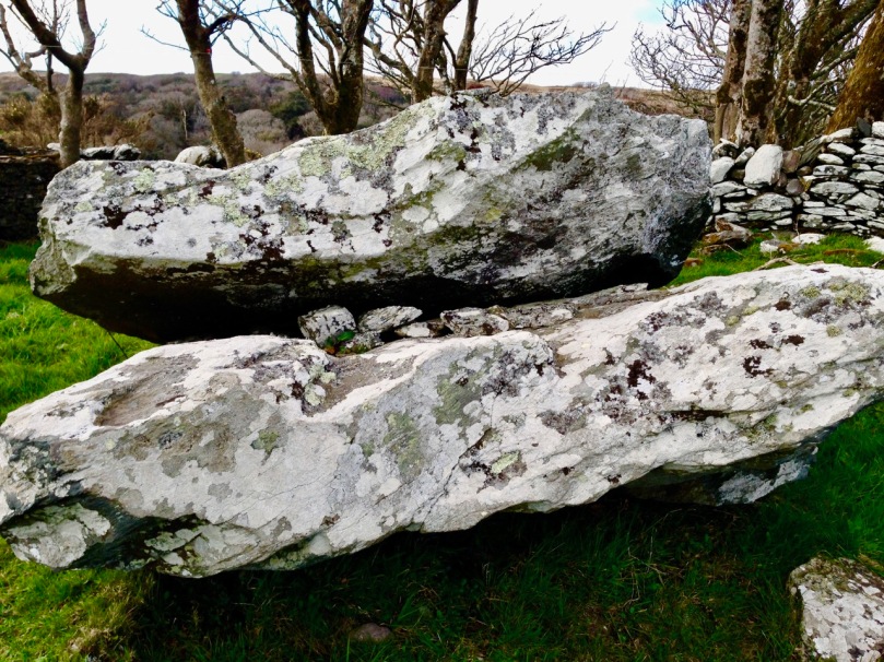
Things did not look promising as we arrived at the Giant’s Grave – cloud and fog

We devoted two posts recently to the subject of Boyle Somerville. The first was a post about his life and his pioneering work on what is now called archaeoastronomy, but which he called the new science of Orientation. The second was about a site that was close to his home in Castletownshend, Knockdrum Fort. In Boyle’s own article on Knockdrum (available online with a JStor subscription), he notes a particular orientation between two fallen galláns (or standing stones) on a slight prominence in the grounds of Drishane House, to Knockdrum Fort itself at sunset on Bealtaine in 1930.

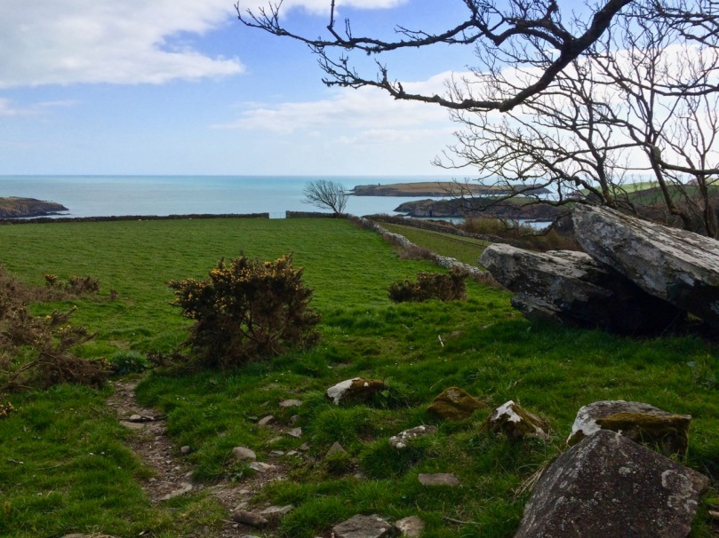
Standing behind the Giant’s Grave, Knockdrum Fort is clearly visible on the horizon

On that day, he states, he stood on the fallen galláns and watched the sun set directly over Knockdrum Fort. Yesterday, we did the same thing. It was a nerve-wracking business as not only cloud cover but a constant drifting fog obscured the hills and we were not hopeful that we would be able to see anything at all. But Boyle was up there, looking down on us, and at the last minute the clouds parted and there was the sun, exactly where he said it would be, angling slowly down to the fort.

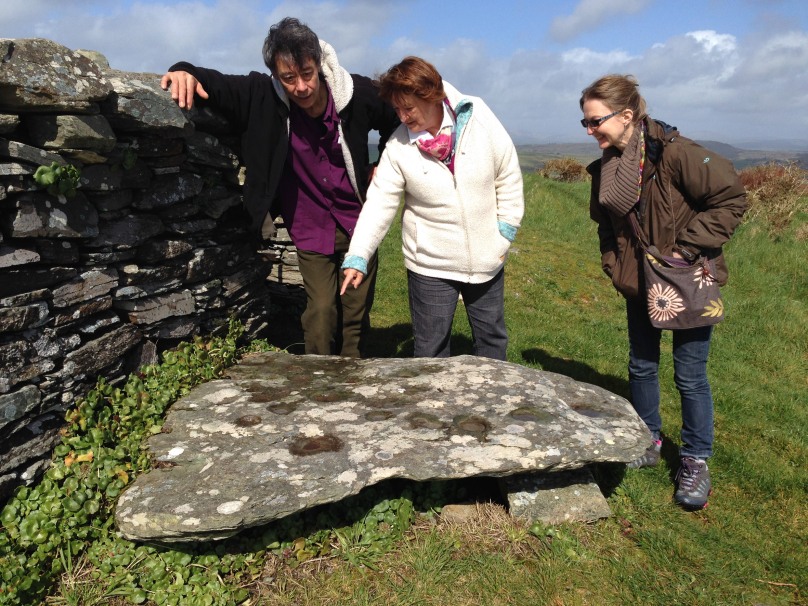
The sun lights up the Giant’s Grave, making the cupmarks on its surface more visible

Watching this descent was a real highlight of my life here in West Cork. First of all, it felt really special to be on the same spot as Boyle Somerville, 88 years later to the day, and verifying his sighting by recording the phenomenon with photographs and video. If anyone else has done it in the intervening years, we can find no record of it, but would love to hear about it.

Secondly, this is essentially a rock art story, rather than a stone fort story. As Boyle himself pointed out, the stone fort at Knockdrum is but one piece of evidence of a long and continuous use of this commanding site. There are two carved stones at Knockdrum, one outside the fort with cup-and-ring type carvings, and a cup-marked stone currently lying within it. Look back at Robert’s post to see photographs and drawings of these two stones. These examples of rock art are likely the oldest artefacts on the site, dating to between four and five thousand years ago. There is also a cross-inscribed slab, possibly indicating an Early Medieval use of the site for ecclesiastical purposes. The stone fort itself may have been a relatively recent period of occupation, marking it as the fortified residence of a high-status individual about a thousand years ago. Boyle felt it may even have been used for look-out and defensive purposes in the seventeenth century.


Robert’s 2014 drawing of the surface of the Giant’s Grave capstone with 17 cupmarks

But the fallen galláns, known locally as the Giant’s Grave, also have cupmarks, tying them to the rock art tradition. The upper surface of the top slab has 17 cupmarks. Boyle counted 19 and the National Monuments record has it as 12, showing how difficult it can be to accurately identify man-made marks on a rough and heavily-lichened surface.

The Giant’s Grave, or fallen galláns, from the west side

While Boyle described this monument as two fallen galláns, it is unclear whether the placement of the two stones, one on top of the other, is accidental or deliberate. If deliberate, then this may be another type of megalithic structure, perhaps similar to a boulder burial (or clochtogle, as he preferred to call them). The orientation, then, as observed by Boyle in 1930 and by us in 2018, is from this probably Late Neolithic or Bronze Age structure to the place where other other pieces of rock art originally stood. Intervisibility, or the visibility of one piece of rock art from another, is well established in the Irish rock art literature. While we have written before (see here and here) about orientation from a piece of rock art to horizon markers, we have never before recorded a specific orientation, involving a solar event on a calendrical day, between rock art sites. So, this is a first for us, and may be a first for Ireland.

This is the Gortbrack stone, on its stand in the Stone Corridor at University College, Cork (UCC). It came from the townland next to Knockdrum Fort

In fact, it is easy to forget that three other examples of rock art come from adjoining townlands because they are no longer in situ: one is in the grounds of Drishane House and two are in Cork City. Six pieces of rock art less than 3 kilometres apart make for a ‘concentration.’

Above, the rock art currently in the grounds of Drishane House, but originally from Farrandeligeen

The Drishane House stone came from Farrandeligeen, immediately west of Drishane townland. In the field notes kept by Boyle, and discovered by Dr Elizabeth Shee, he notes that the stone was originally built into the wall of an outhouse. . . but was brought to Drishane House by Colonel Somerville in about 1880, for safe keeping.

This is one side of the Bluid Stone (both sides are covered in cupmarks), which is housed at the Cork Public Museum

The other two pieces are from the townlands of Gortbrack, immediately to the west of Farrandau (the townland in which Knockdrum Fort is situated) and Bluid (either East or West) which is to the west of Gortbrack. Gortbrack is in the Stone Corridor at University College Cork, and the Bluid stone (an unusual two-sided example) is at the Cork Public Museum. Both had been in the possession of Boyle Somerville, and were presented to UCC after his death. They had been brought to him by local farmers who knew of his interest in such things. We can only lament that of the six separate examples of rock art known from this immediate vicinity, we can be reasonably confident that only one, the Giant’s Grave, is in its exact original location. Neither of the two pieces at Knockdrum Fort are precisely where they were found, but at least they do not seem to have been moved more than a few metres from their original situations.

There is scope for much more investigation of this intriguing group – we shall call it the ‘Boyle Somerville Rock Art Concentration’. But for now, let us once more raise a toast to Boyle, pioneering archaeoastronomer of West Cork.  His legacy lives on.

Knockdrum Stone Fort

There is no firm line that denotes where our most south-westerly Irish peninsula begins. Our series, Mizen Magic, has reported on walks, roads, views, history and archaeology which can definitely be defined as belonging to the Mizen (which we tend to think of as being to the west of, and including, its ‘gateway’ – Ballydehob). Perhaps we should start a series titled Magic Beyond The Mizen – in which case this would be the first: a report on a very prominent site about half an hour’s drive along the coast east of where we live: a historic structure – built within the last 2,000 years – but which contains evidence of much older human activity.

Here is an overhead view – the best way to see and understand the layout and construction of Knockdrum Stone Fort, which occupies a superb hilltop location in the townland of Farrandau between Skibbereen and Castletownshend. Thank you, Dennis Horgan – our professional West Cork aerial photographer – for allowing us to use this image: have a look at his website for other examples of his work, and for details of his excellent photographs and books.

The Fort is located on a high ridge (although not on the summit of the ridge) with far-reaching views both inland and to the south, over the sea. The header picture looks from the Fort out to the west over Castlehaven to Galley Head in the far distance; the view in the picture above is due south – looking towards Horse Island, and the stone wall of the Fort is in the foreground. From these breathtaking vistas it’s reasonable to conjecture that Knockdrum Fort has a strategic siting, providing views of anyone approaching from the sea, and able to signal their arrival to dwellers in the ‘interior’ – the lands to the north. We cannot know for sure that stone fort structures had this – or any other – specific purpose: many theories have been advanced. Comparison with other examples is worthwhile. One of the largest stone forts in Ireland is Staigue Fort, near Sneem in County Kerry.

Staigue Fort (above) has a diameter of 27.5 metres, the present wall height is 5.5 metres, and the wall thickness is 4 metres. At Knockdrum the diameter is 22.5 metres, the present wall height is 2 metres and the wall thickness around 3 metres. The Duchas information board at Staigue says:

. . . This is one of the largest and finest stone forts in Ireland and was probably built in the early centuries AD before Christianity came to Ireland. It must have been the home of a very wealthy landowner or chieftain who had a great need for security . . . The fort was the home of the chieftain’s family, guards and servants, and would have been full of houses, out-buildings, and possibly tents or other temporary structures. No buildings survive today . . .
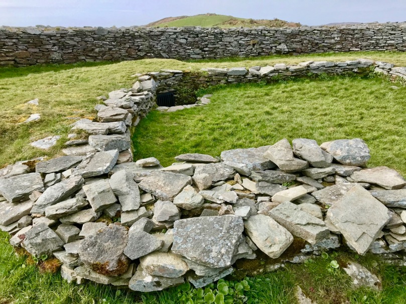
The picture above shows the present interior of Knockdrum Fort: the stone walls are likely to delineate a former building here. In the corner of the inner stone enclosure is the entrance to a ‘souterrain’ – a series of underground passageways. The souterrain is outlined on the following drawing of the Stone Fort which was made in 1930 after a detailed investigation of it by Vice Admiral Henry Boyle Somerville, the younger brother of writer and artist Edith Somerville of Castletownshend. Boyle, his life and his tragic death, is the subject of Finola’s complementary post today.

Finola is also discussing Boyle Somerville’s interest in the alignments of archaeological structures. In Boyle’s paper for The Journal of The Royal Society of Antiquaries of Ireland, 1931 (title page below), he presents the evidence that this Fort is on a solar alignment.

Boyle sets out the case for an alignment based on the Knockdrum Fort:

. . . This conception of the earlier use of the site of the cathair [the stone fort] for purposes which may perhaps be termed “religious,” seems to be borne out by the following fact. At a horizontal distance of about 600 yards to the E.S.E of the cathair, and at 210′ difference of level below it, there is a small rocky ridge standing up from the surrounding grass land. The name of the ridge is “Peakeen Cnoc Dromin,” The little peak of the white-backed hill . . .

The following paragraphs and photos are from the Journal paper:

Finola and I are familiar with the Peakeen Cnoc Dromin from our researches into Rock Art: the uppermost stone (which does appear similar to the capstone of a fallen dolmen) is heavily cupmarked. The photos of the Peakeen (above) were taken before we had any idea that they might form an alignment connected with Knockdrum Stone Fort. We will have to revisit again at Bealltaine. Boyle confirmed his alignment theory by personal observation:

He went on to suggest:

. . . It is one of the clearest instances of intentional orientation between two ancient, and artificially formed monuments that can be imagined . . .

Of course, it can’t be the case that a cupmarked stone dating from anywhere between 3,000 to 5,000 years ago was in any way connected with a stone fort that dates from the early part of the first millennium AD. However, I have as yet omitted an important piece of information: at Knockdrum Fort, high up on the hill, are two further ancient cupmarked stones – and significant ones: the larger also exhibits Rock Art. Somerville illustrated them in 1930, and Finola recorded them in detail in 1973.

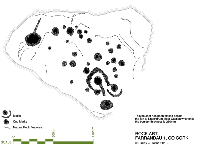
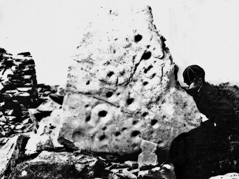
Images above are of the stones recorded at Knockdrum: topmost is Boyle’s drawing from 1930. Below Finola’s drawings are photographs of the large stone lying by the Fort entrance today: it is known that this has been moved, possibly during Somerville’s time. The old photograph immediately above is from the Coghill Family Archive and shows Arthur Townshend beside the stone, which is standing. Arthur was born in 1863: this photograph may record the occasion of the expedition by the young Somervilles and ‘their cousin’ (quite possibly Arthur) to Knockdrum described below, which took place in 1875. It is the presence of Rock Art and cupmarks at the Fort itself which tells us that the site must have had significance in far earlier times (perhaps that’s why the fort was sited in that location – rather than on the summit of the ridge), and Boyle’s reported alignment would have been with the carved rocks (or the important location that they marked) rather than with the comparatively modern stone fort.

The souterrain in the enclosure of Knockdrum Fort (entrance in top photograph – ‘chimney’ in lower photograph) was explored in 1875, as Boyle recounts:

The ‘band of three youthful archaeologists’ are likely to have been Somervilles: Edith (the eldest, then 17), Boyle (then 12 – it was he who was lowered down into the discovered ‘cave’ by his ankles!) and, probably, a cousin. Great adventures, which would undoubtedly raise eyebrows today.
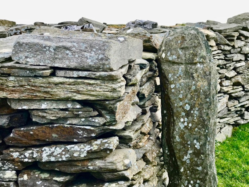
Within the fort enclosure is this cross-marked stone. It was apparently leaning against the wall in Boyle’s days, but has now been embedded close to the entrance. We visit this site often: this time we noted some significant disruption to the upper level of the dry stone walling, possibly caused by the fierce storm winds earlier this year. Compare the detail below with Dennis Horgan’s aerial view above, taken a few years ago.

Some damage has also been suffered to retaining walls on the green boreen leading to the Fort from the main Skibereen – Castletownshend road (a walking route only), and on the stone walls beside the 99 steps which take you from the green path to the top of the hill. These are passable with care, but it is hoped that this monument – which is in State ownership – will be deservedly returned to good order before too long: it is one of the historic wonders of West Cork.

Boyle Somerville: Ireland’s First Archaeoastronomer

Henry Boyle Townshend Somerville (1863 – 1936) is mostly know in Ireland now for how he died, murdered by the IRA in 1936. And that’s a tragedy in many ways, not least of which is that the notoriety of his death has obscured his important contributions to Irish archaeology and especially to the once-controversial field of archaeoastronomy, of which he was a distinguished pioneer. [The portrait above is by Walter Stoneman and used with permission from the National Portrait Gallery under a Creative Commons License.]

Boyle was about 30 in this photograph. This illustration is from Somerville and Ross: A Biography by Maurice Collis. The family lived in Drishane House, below, in Castletownshend, West Cork. 

Boyle was one of the famous Castletownshend family of Somervilles that included Edith, the writer with Violet Martin of the Irish RM stories. He was her favourite brother and companion on youthful adventures, including the incursions into the souterrain at Knockdrum Fort, armed only with a poker and a candle. See Robert’s companion piece about this ancient site.

Boyle drew the first proper survey of Drombeg and his observations established the winter solstice orientation. Today, crowds gather to witness this spectacular event

He went off to sea in 1877 at the early age of 13 – seafaring was in the Somerville blood – and rose through the ranks of Commander, Captain and finally Vice-Admiral. Throughout his time in the navy he was engaged in surveying and in hydrographic, intelligence and research projects all over the world. He collected ethnographic materials (now in the Pitt-Rivers Museum) and wrote papers on his experiences.

Another one of Boyle’s stone circle solar events, this one occurs at the autumn equinox at Bohonagh

But it was astronomy that fired his imagination, and specifically the astronomy of ancient sites. Following on the work of astronomer Norman Lockyer, he surveyed monuments in Scotland and Ireland and demonstrated that many of them had significant solar, stellar and lunar orientations. His 1927 paper, simply titled Orientation, in the first issue of Antiquity is a readable and well-argued essay that argues for the acceptance of the importance of calendrical observations to early farming communities.

The Bohonagh complex of monuments as Boyle described them – a stone circle, a cup-marked stone and a boulder burial

It is hard to remember now that the scientific community of the time was dismissive, but even the writer of his obituary in the journal of the Royal Society of Antiquaries of Ireland could not resist a patronising summation:

He was an accomplished surveyor and careful observer, and if the theories as to the orientation of megaliths which he held are not universally accepted, his investigations have resulted in presentations of an accuracy too often absent from the surveys of many writers on those subjects.

Makes him sound like a crank, doesn’t it? But let’s go back to that bit about being an ‘accomplished surveyor and careful observer.’ In paper after paper, he did just that – carefully observed and documented the archaeological monuments of West Cork and elsewhere. It was he who first described the West Cork Stone Circles and coined the term recumbent, providing properly surveyed plans and making careful notes of the way in which they offered sightings to solar events at significant times of the year through the axis provided by the line running from the ‘entrance’ through the ‘recumbent.’ (For an explantation of how this all works, see our post Ancient Calendars.)

Reenascreena Stone Circle with its surrounding shallow fosse

Take a look at a couple of his papers for the Cork Historical and Archaeological Society. The first, on Five Stone Circles, is a good example of how he conducted his surveys. The second, titled Prehistorics sets out the case for a proper classification system for megalithic structures. Most of the terms he recommends, such as Standing Stone, Stone Row, Stone Circle, Passage Grave and Cup-Marked Stone are familiar to us and in everyday use now and he probably didn’t coin the terms. However, one of his terms never gained acceptance, and I think that’s a pity. It’s the charmingly named ‘Clochtogle’ and it’s what we now call a Boulder Burial. But in fact Clochtogle is a better term in being simply descriptive rather than assigning a function, since, as he points out in his paper, and as I pointed out in this post, there is precious little evidence that points to these monuments being burial places and they seem singularly unsuited for that function.

The Rathruane Clochtogle

Clochtogle is based on the Irish term cloch tógáil (cluck toe-gawl) which simply means raised up or lifted stone. We have lots of them in West Cork. In looking at the photograph of the Rathruane clochtogle (do you think this term might still catch on?) I am struck by how it seems to mirror the shape of Mount Gabriel in the background. Boyle, in his writings, did point out that not every monument was oriented to quarter or cross-quarter calendrical events: some, he said, may have other traditions reflected in their orientations. In our own investigations of West Cork monuments we are constantly struck by how many encompass views of Mount Gabriel.

Brian Lacey has an excellent paper in the Journal of the Royal Society of Antiquaries of Ireland* in which he describes Boyle Somerville as an important and distinguished. . .Irish archaeologist. . .and one of the founders of international archaeoastronomy. He details his various contributions to the field, and does not shy away from mentioning his less-than-scientific interest in ley-lines and also in the use of a medium to communicate with the builders of Drombeg. Edith, along with most of their circle (and indeed many of the literati of the time) routinely used mediums and ouija boards. After his death, as her biographer Maurice Collis puts it, Edith ‘lost no time in getting into touch with Boyle.’ But this does not detract from Boyle’s ultimate contributions: Without any doubt, states Lacey, Boyle Somerville was an extremely important and internationally-influential Irish archaeologist for his time. He deserves to be remembered better and celebrated with pride in this country.

Boyle’s death, at the hands of an IRA hit squad, triggered a national outcry. There’s a good account of it here so I won’t repeat the information that is widely available. I will emphasise, though, that the murder horrified the local community and brought together Catholic and Protestant in mourning the death of one who was highly regarded and universally respected in Castletownshend. Edith determined to raise a monument to the memory of her beloved brother and the notion that took was to erect a bench outside the entrance to Drishane House for the use and enjoyment of the village. She asked Seamus Murphy to execute it, one of his first commissions. Next time you come by, linger at this spot and reflect on the life of Vice-Admiral Boyle Somerville. Accomplished, erudite, decorated and distinguished, he is remembered by those who knew him by the simple and deeply moving words Cómharsa Maith – Good Neighbour.

*The Skibbereen and District Historical Journal, Vol 7, 2011, also has a paper by Brian Lacey about Boyle Somerville, substantially similar to the one in the RSAI Journal. It is not available online.


Castle Haven

The entrance to Castle Haven. Horse Island is separated from the mainland by the charmingly named Flea Channel.

The entrance to Castle Haven. Horse Island is separated from the mainland by the charmingly named Flea Channel

South West of Skibbereen lies a deeply indented section of the coast known as Castle Haven. It is perhaps best known for the town that clings to the steep hill on its west side – Castletownshend. We have written much about Castletownshend itself, about Edith Somerviille and about the lovely St Barrahane’s Church and its Harry Clarke windows. But the whole inlet is an explorer’s paradise, yielding up its treasure to us on successive visits so this post will be about other things to see around the Haven.

Castle Haven

Catle Haven on a misty day. The inlet was guarded by two castles: this one at Raheen and another at the entrance to the Haven

The Haven is shallow at its top end, but up to the spit of land that runs across it near Reen Pier, it provides a deep and sheltered harbour for boats, and a popular sailing ground. We like to drive down the road that runs above the eastern side of the Haven. It’s twisty and a bit treacherous but at a certain point it presents a view of the whole inlet, dominated by Raheen Castle.

Raheen Castle

This was a castle of the O’Donovan clan, built in the late 16th or early 17th century. It didn’t last long – it was attacked by Cromwellian forces in 1649 and the collapsed upper stories may be the result of cannonball damage.

Raheen Corner machicolation

Continuing to the end of the east side brings you past Reen to the wonderful harbours of Myross and Squince, but that’s a post for another day. Now we’ll return to the west side of the inlet and visit two spectacular archaeological sites, Knockdrum Fort and the Gurranes Stone Row, before proceeding down into Castletownshend.

Knockdrum interior and views to north

The interior of Knockdrum Stone Fort, with square hut site in the middle. The fort commands panoramic views across the countryside and out to sea

To get to Knockdrum Fort, you have to park at the large church about 2km before the village. Walk downhill about half a kilometre until you get to the signposted green road to the fort. A pleasant trudge brings you to a set of steps and these lead up to the site. This is an excellent example of an early medieval stone fort – the kind of fortified homestead that marked the residence of a family of high status before the Normans taught us how to build tower houses.  From this site there are striking views across Castle Haven.

Entrance to Knockdrum

The entrance to Knockdrum Fort, looking towards the entrance to Castle Haven. Outisde the entrance is this large rock, covered in cup-and-ring art

But there’s more to this place than just the fort. There’s an early Medieval cross slab just inside the entrance, and a fine example of 4000 or 5000 year old rock art just outside it. There’s another piece, a cupmarked stone, inside the fort, lying on the ground. All three are here thanks to the activities of Boyle Somerville, a keen amateur archaeologist and brother of Edith Somerville who lived in Drishane House, just below the fort. Farmers who found such items would bring them to him and he placed them here for safekeeping. Also inside the fort you will see evidence of a souterrain – an underground passage used for storage when the fort was active.

Knockdrum cross slab

If you look north across the valley once at Knockdrum you will see a stone row on a nearby hill. These are the Garranes ‘Fingers’. (They are on private land so you should seek permission to visit and make sure there are no bulls in the fields.) The best way to access them is to tramp through the fields across the road from the entrance to Knockdrum. It’s well worth the effort – once you get up to them you will see that more uprights are now lying on the ground. This was originally an alignment of at least five stones, unusually tall and thin, positioned so that they would be visible on the skyline from many directions.

Gurranes Fingers

Drive down towards the village now, until you get to the entrance to Drishane House. To the right of the gate is a bench dedicated to Boyle Somerville. In 1936 he was shot dead by the IRA, who claimed he was recruiting local young men for the British Navy. He was liked and respected locally and, outraged by the deed, the people of Castletownshend raised money for this memorial. If the house is open (there will be a sign) this is a wonderful place to visit. For a small charge you can wander around the extensive grounds and visit the Edith Somerville Museum. We love to go in spring, when the bluebells provide a vivid carpet and a photographer’s paradise.

Drishane house driveway in spring

Drishane House driveway in the spring, with the giant macrocarpa (a Californian cypress tree)

Down to the village now and up to the church. But this time, instead of heading inside to see the Clarke windows, or behind the church to view the graves of Somerville and Ross, cross the graveyard until you find a gate at the far side and head east along the edge of the field towards the water. There you will find the remains of a structure labelled as a star-shaped fort on the OS map. Nowhere near as enormous as the massive star-shaped Charles Fort in Kinsale, nevertheless it is a reminder of a time when the sleepy village was not as peaceful as it is now. Dating to the 1650s, not a lot remains, just enough to confirm that this was a structure built for defence. Along the way you might also see a ruined square tower, known as Swift’s Tower. This was built as a belvedere, (a place to admire the view) and legend has it that Dean Swift visited and liked to write there.

Left is the remains of a bastioned fort, labelled as a ‘Star-Shaped Fort’ on the OS map. Right is the belvedere, where Swift is said to have written

Drive back out of town now and take the left turn after the entrance to Drishane House. Follow this road for about a kilometre to a sharp left turn, just before a small crossroads and turn left down a narrow road that ends at the sea. A tower house used to guard this part of the Haven but nothing remains of it now except a stump covered in ivy and brambles. But wander around the graveyard and admire the picturesque siting of the old church, already in ruins by the mid-1600s. This is a good example of a classic West Cork graveyard. Most graves are marked by simple stones at the head and foot, with no inscriptions. 

Castlehaven Graveyard atmosphere

There are some family plots and some more elaborate memorials, including one for Ellen Buckley, second wife of O’Donovan Rossa (although his name, interestingly, does not appear on the headstone).

Castlehave graveyard, old church

To the immediate left of the graveyard you will find a stile leading to a green path. Take this path and walk up though the luxuriant woods past a rushing stream until you come to a little wooden bridge.

Path by the stream

On the other side is a holy well, cut into the hillside and decorated with ribbons and fishing floats. Make a wish, or say a prayer – this is a special place and still visited and maintained by local people.

Take OS Discovery Map 89 with you. Most of the sites I describe are actually marked on it. But if you get lost, have fun, and let us know what you discovered!

Path through woods