Illaunloughan

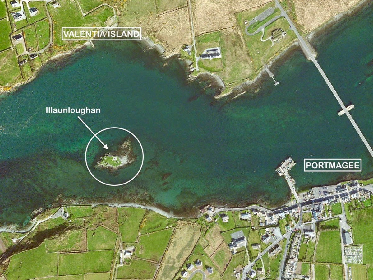
We embarked on a sea voyage in order to explore the island of Illaunloughan, which is off the coast of Kerry not far from Portmagee. To the north is Valentia Island. It is said that this tiny landfall – only 0.3 acres in area – is the smallest of Ireland’s offshore islands which contain medieval monastic remains.

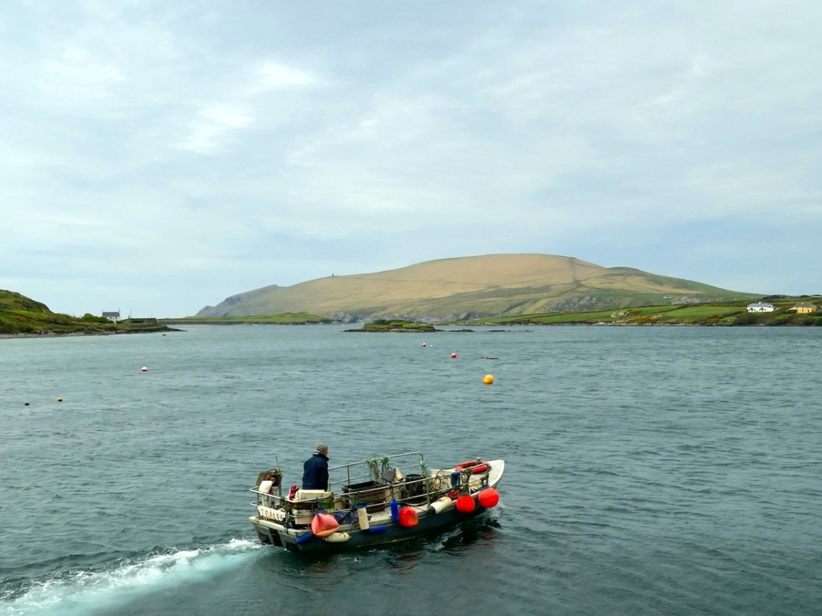
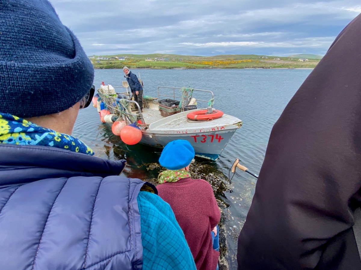
Our sea journey was on board an aluminium fishing boat – there it is, below, with the island of Illaunloughan in the background.

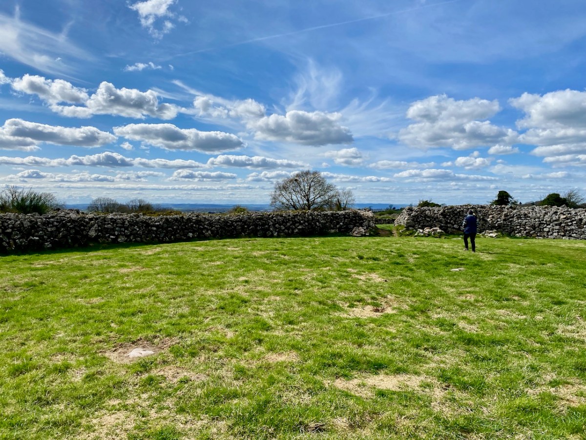
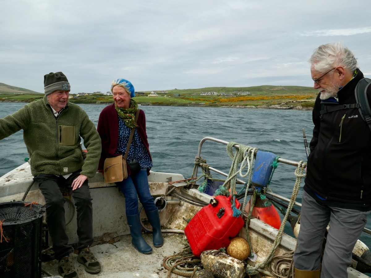
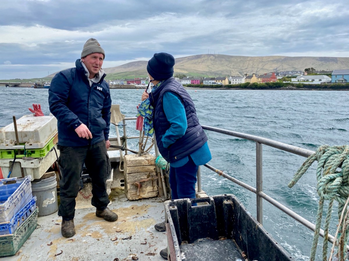
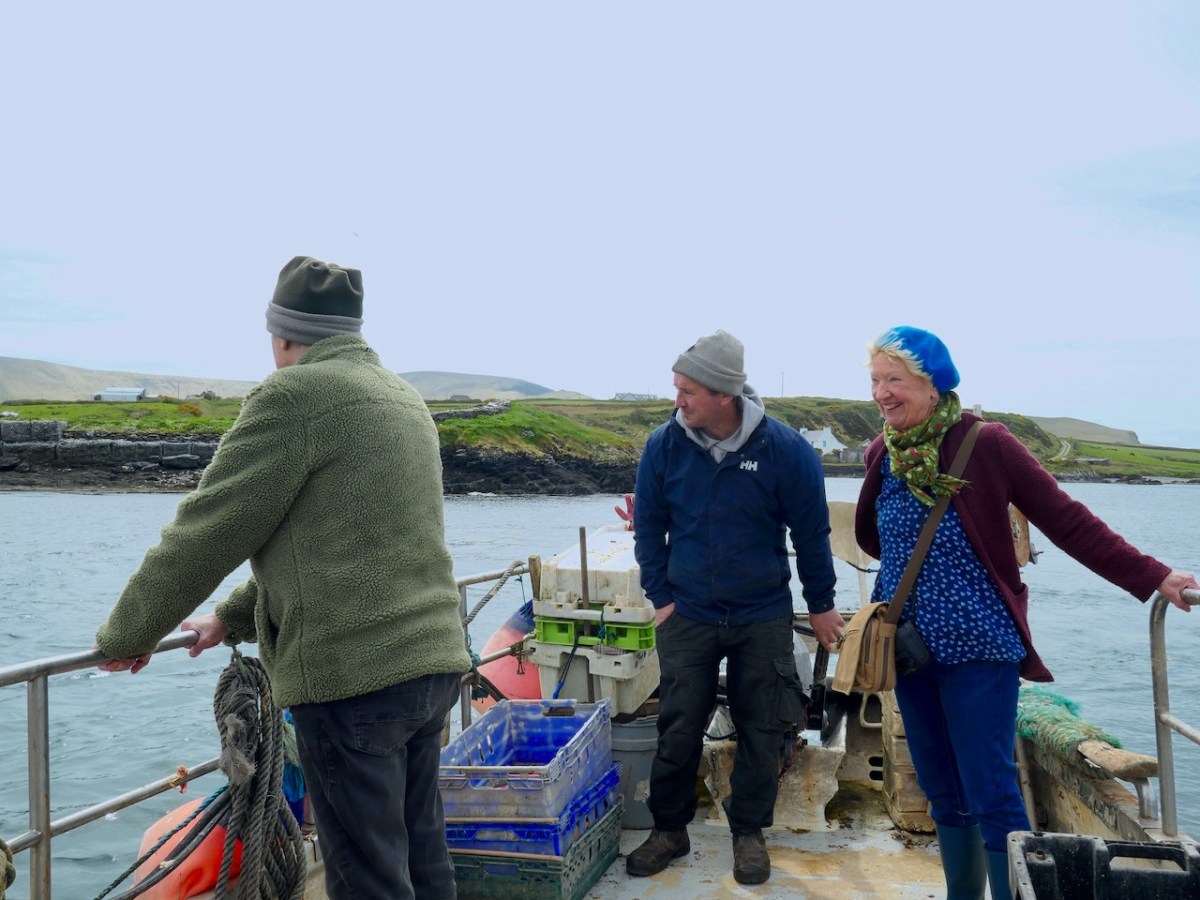
And there’s the full crew (two pics below): myself, Amanda, Peter, David the boatman and Finola. We were – as you might guess – on an archaeological expedition in Kerry, which included the search for a holy well on this island.

You can see Portmagee in the background of the photo above. It’s not a long journey: just a few minutes from the harbour there. In fact it is said that on a couple of tidal events during the year you can actually walk across to Illaunloughan, but the voyage was far more exciting for us!

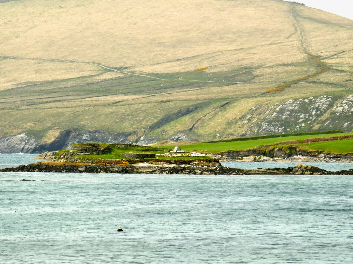
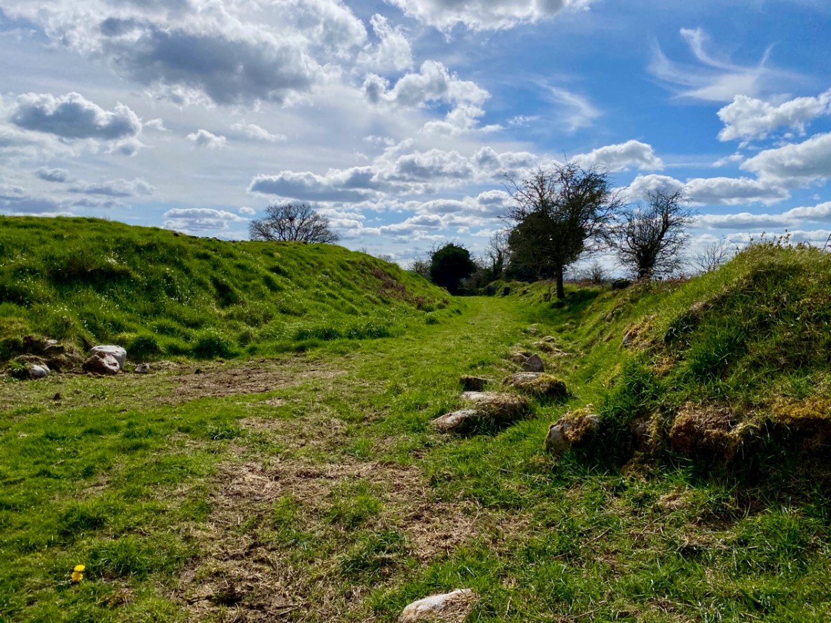
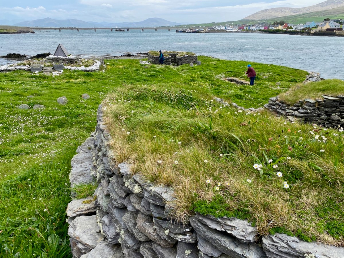
This is the view of the island as the boat approaches it: you can see various of the archaeological features. It doesn’t take long to explore – but it’s fascinating. A full survey of the surviving monuments was undertaken by Jenny White-Marshall and Claire Walsh in the 1990s: this resulted in the publication Illaunloughan Island: An Early Medieval Monastery in County Kerry, Wordwell Press, 2005. Here is a synopsis:

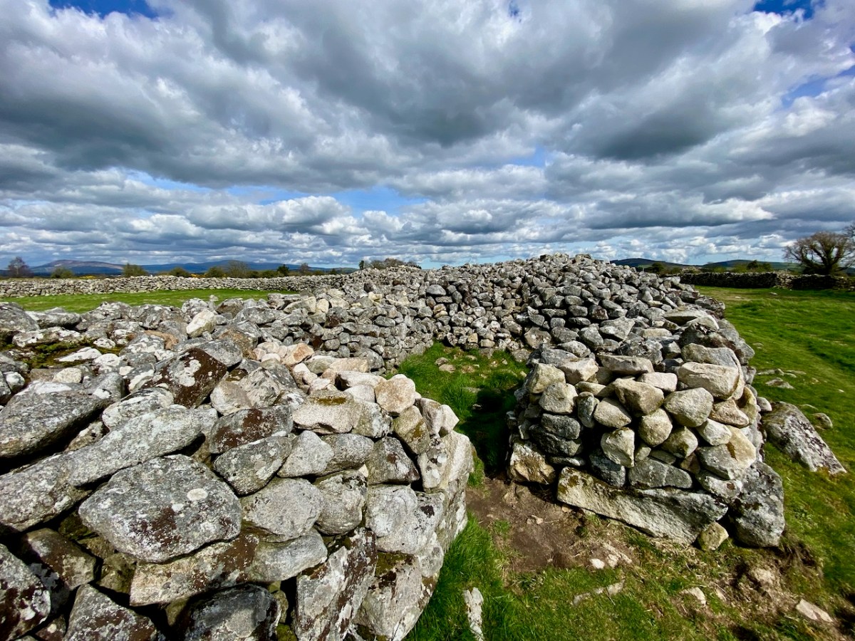
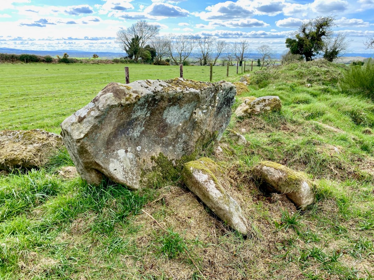
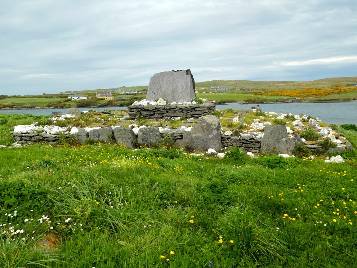
 . . . The gable-shrine is one of a small group of reliquary shrines that occurs at the western end of the Iveragh Peninsula: similar examples are found at Killoluaig, Kilpeacan and Killabuonia. These shrines or specially marked graves are generally ascribed to the founder. The base of the gable-shrine at Illaunloughan consists of a large terraced mound, 9m by 7.6m, which rises to a height of 1.5m. The mound is partly built on an area of rock outcrop which was levelled off on its southern side with soil, stone and pea-gravel. Vertically set kerb-stones and masonry walling were placed along the edges to retain this fill; the mound has been eroded on the northern side by the action of the sea. White quartz stones of varying sizes were liberally scattered over the mound. At its western edge stone steps lead up to an area of rough paving that surrounds a rectangular drystone structure on which stands the slab-shrine. The end-slabs are missing. When the side-slabs were removed an underlying core of pea-gravel and white quartz was exposed. This sealed two small, irregularly shaped, stone-lined cists, each of contained neatly stacked exhumed human bones. A minimum of three individuals, all male, is represented in this skeletal assemblage which comprised fragments of the skulls of two individuals, a single mandible, and several long bones. Large numbers of scallop shells and white quartz pebbles were placed both within and around the cists.
The eastern quadrant of the gravel mound was evidently planned as a cemetery for monks who wished to be buried close to their saints, for at least five bodies were interred here. These were laid side by side, and were extended inhumations oriented from east to west, with the heads to the west.
Following excavation, much of the shrine platform was dismantled. This revealed three rock-cut graves, all oriented from east to west, sealed beneath the mound material. The graves, located on the north-eastern, the southern and the western sides of the shrine, clearly predate the construction of the mound and shrine. Fragments of human bone were recovered from two of them, including a sizeable part of a shattered femur, found at the western end of the grave. No bone was recovered from the third grave. It is hoped to determine, through trace element analysis, whether the bones in the earlier graves represent parts of the individuals translated into the cists beneath the gable-shrine. The evidence so far collated on the Illaunloughan shrine indicates that it is a multiperiod structure. The presence of a sacred focus (an earlier shrine?) is strongly suggested by the earlier graves, though no trace of any such structure survives. C14 (AMS analysis) dating of bone from the cists beneath the gable-shrine has yielded a date in the early seventh century for one individual and the middle of the eighth century for a second. Half-scallop shells, present in the fill of the cists and on their stone lids, were clearly of some significance to those who interred the translated bones. Some of the scallop shells from the shrine have been perforated and they may have been suspended from cords. The scallop is, of course, the emblem of St James, whose remains were ‘discovered’ in a field of shells in Compostela, north-western Spain, in AD 813. The shrine at Compostela rose to prominence as a place of pilgrimage in the eleventh century (Harbison 1991, 22). This may be further evidence of refurbishment of the shrine at a late period . . .

National MoNuments Historic Environment Viewer

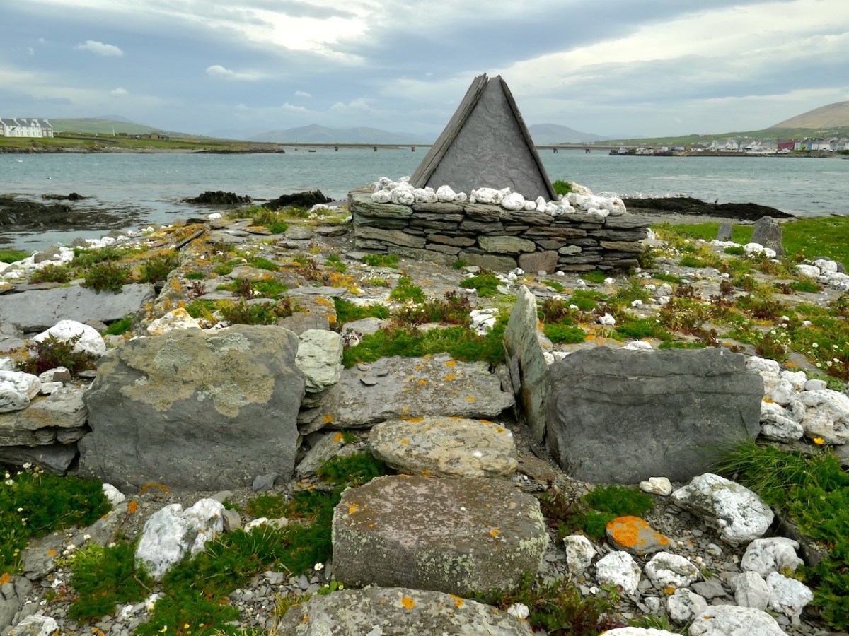
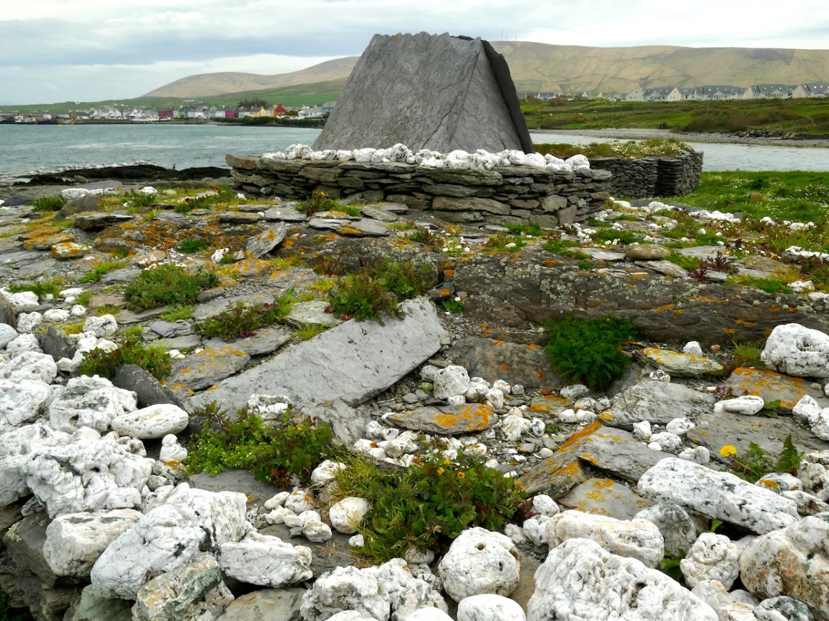
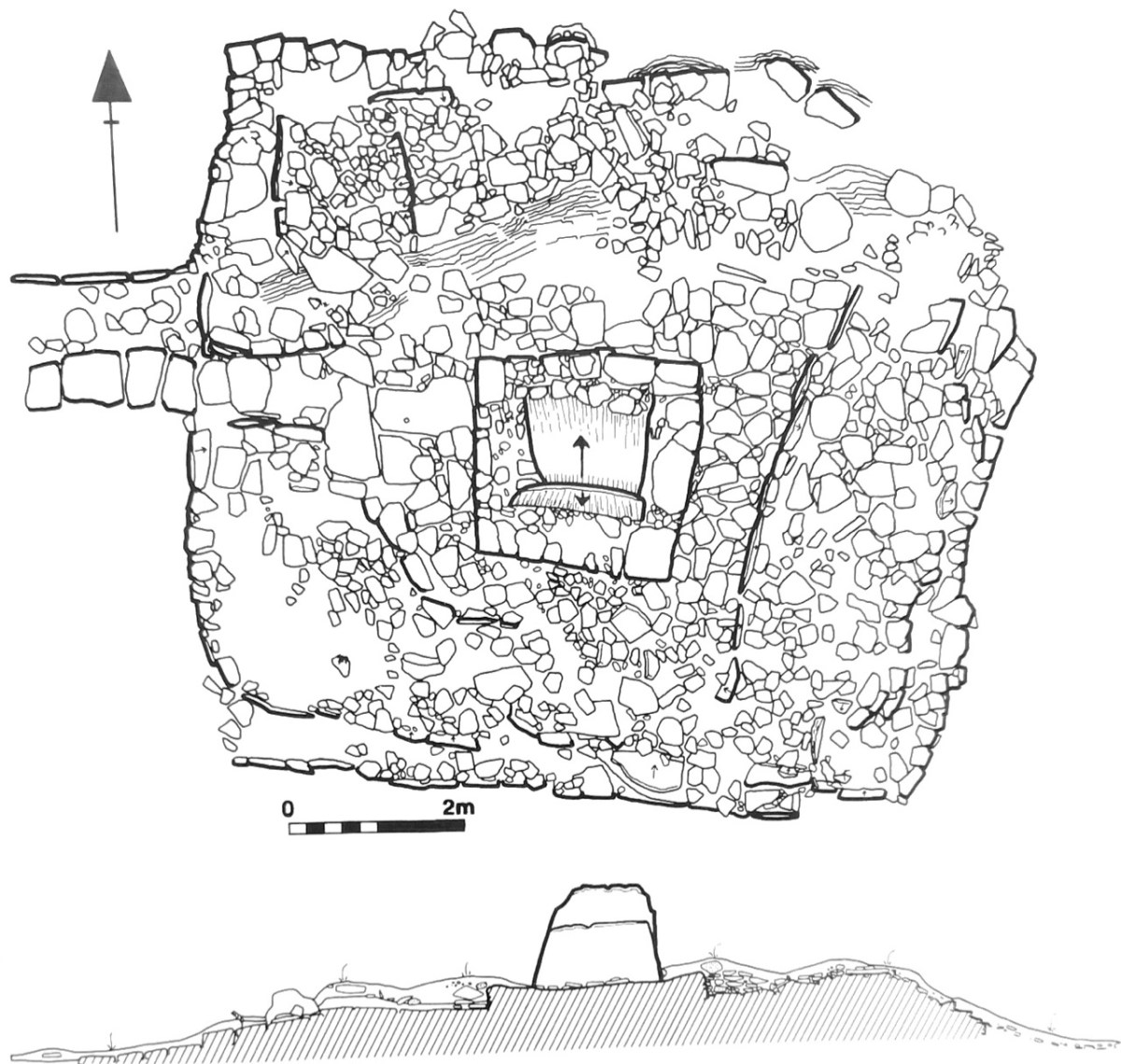
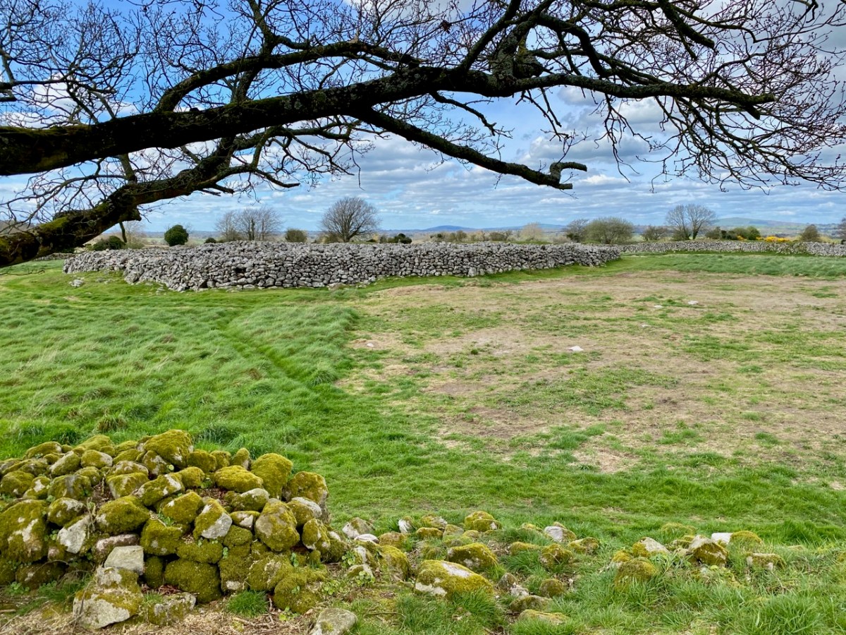
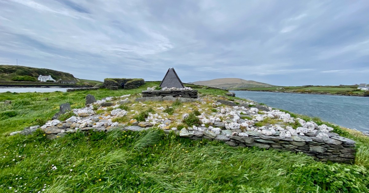
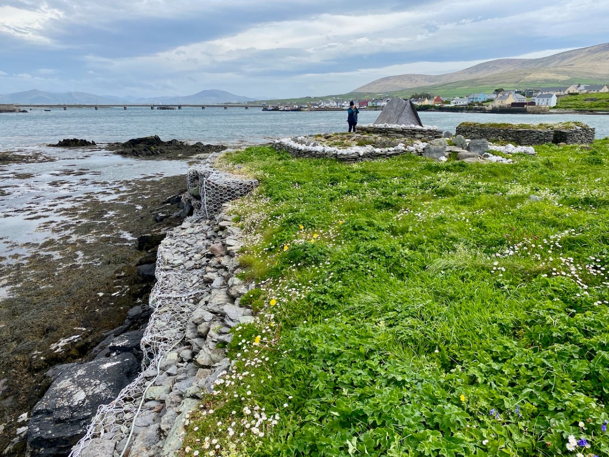
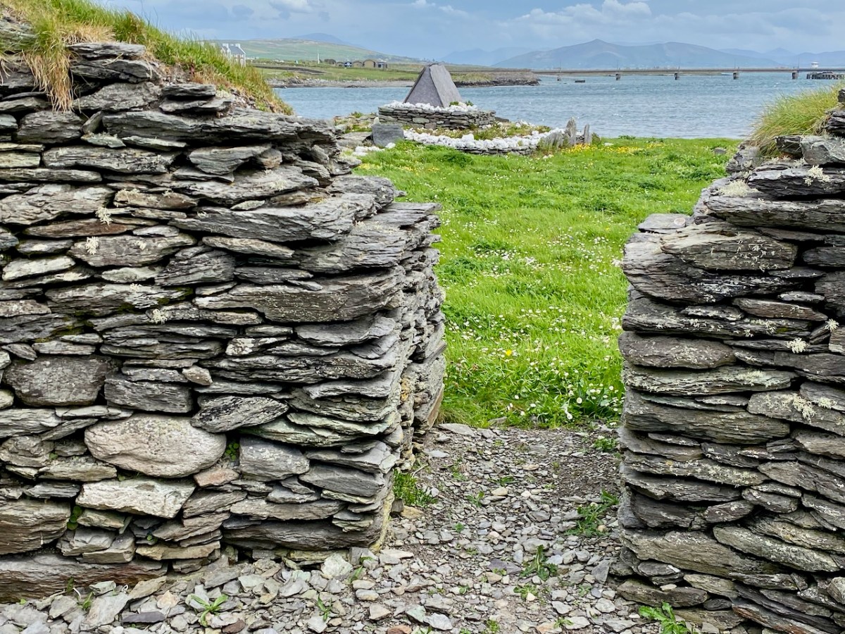
Two views of the gable shrine (upper photographs) together with a scaled drawing from the National Monuments Service (above). This distinctive site, with its embellishments of white quartz pebbles and slate capping, suggests an internment of some great importance – probably a local saint. The gable-shrine was reconstructed after excavation and is now complete. Note from the description above (National Monuments Service) that three rock-cut graves were revealed under the present structure – empty – and the suggestion has been made that the later shrine was constructed to ‘translate’ the earlier burials because of the significant status of those who were buried there.

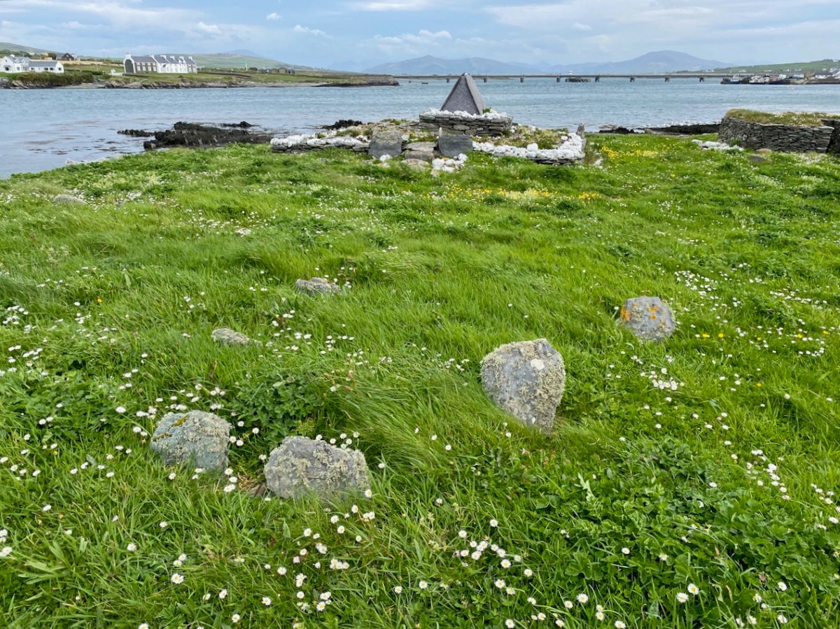
The gable shrine seen with the bridge from Portmagee to Valentia Island in the background. In front of the shrine are (probably much later) grave markers. It was common practice to put burials close to anciently sacred sites: in fact, up to the 20th century Illaunloughan was used as a cillín for the burial of unbaptised infants and as a graveyard by local people.

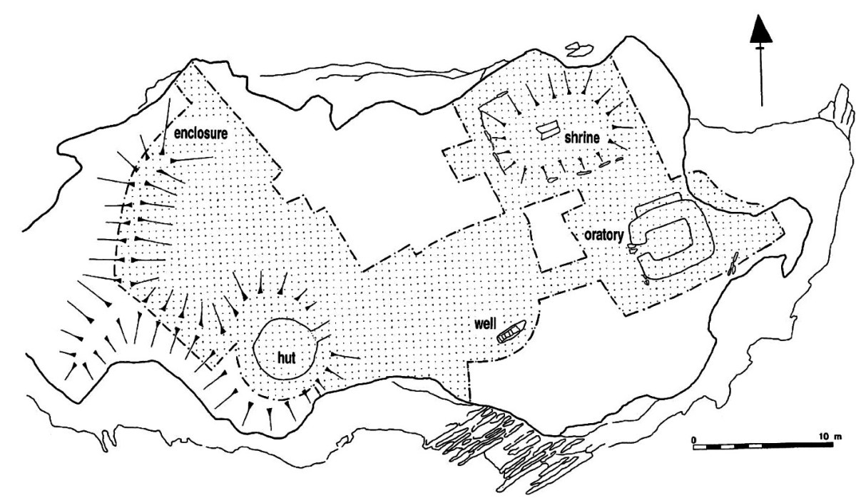
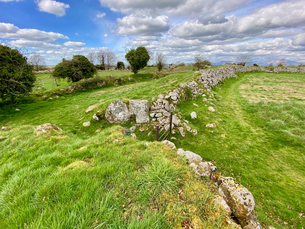
This plan of the island (National Monuments Service) shows the principal features: the gable shrine, an oratory, a stone hut and a well. It also serves to show how small the island actually is – yet it supported a community of men and children (one of the three burials in the shrine was seven or eight years old). Their main diet is said to have been fish and seafowl based. The drystone oratory (church) was excavated and radiocarbon dated to the 8th century. The excavations of the surrounding land revealed that a range of domestic and industrial activities were undertaken, including fine metal-working, bone-working and cereal processing (Irish Heritage News 2018).

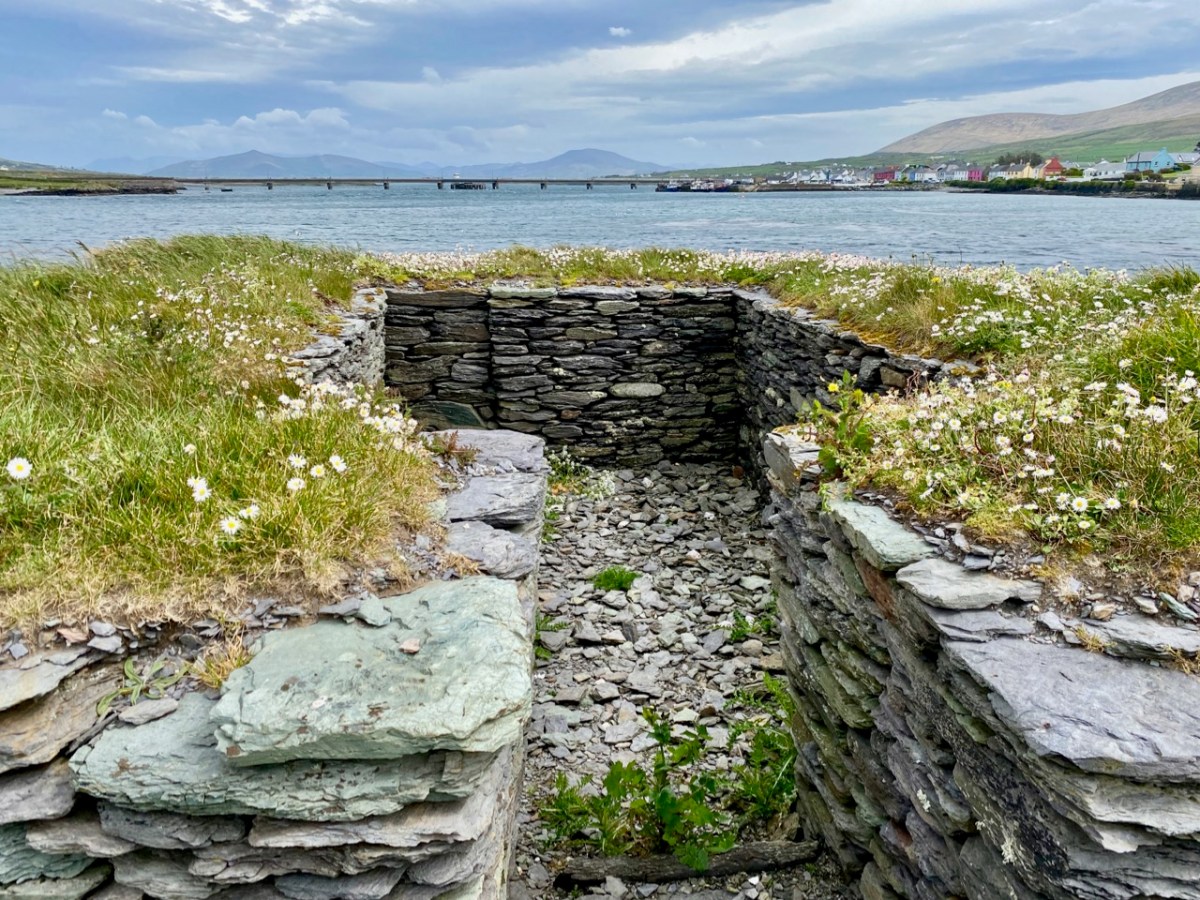
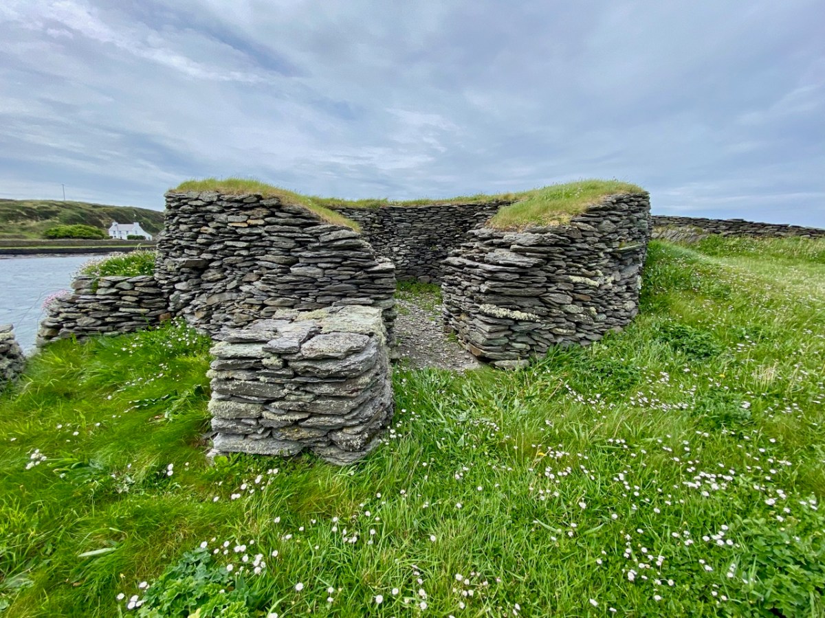
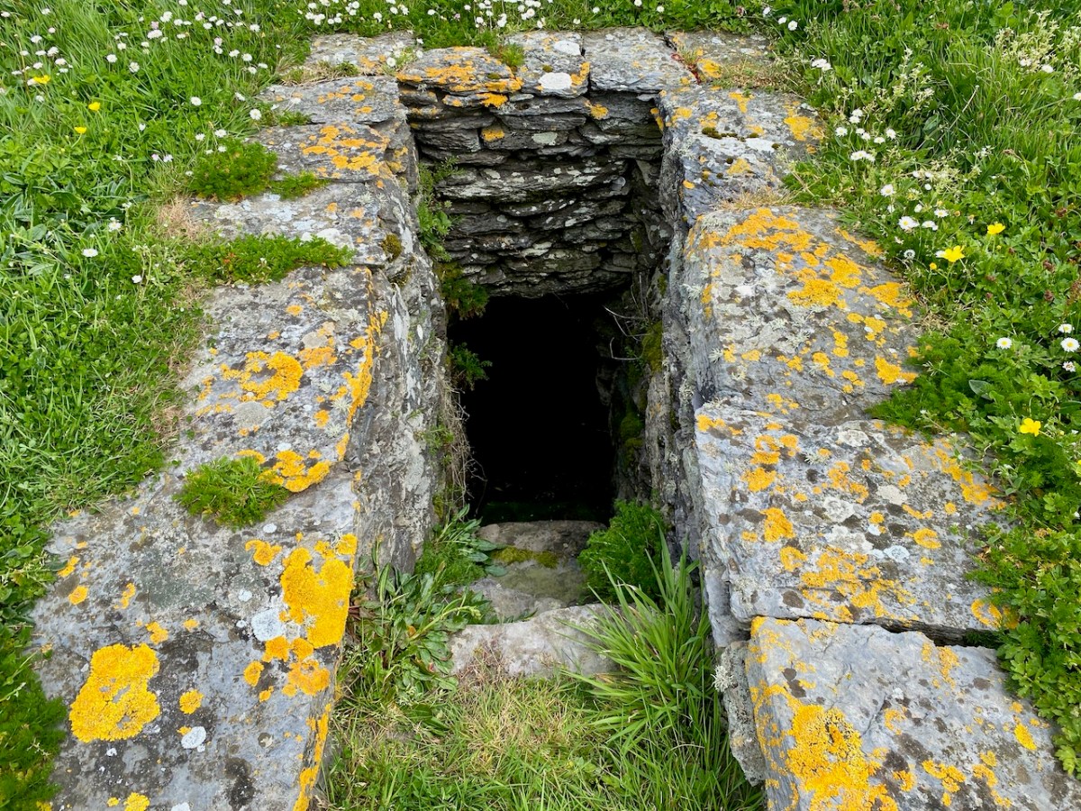
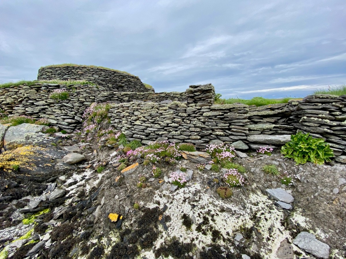
The pics above show the oratory, a stone hut and the well. The latter would have been a necessity for any permanently based community on the island: Amanda’s particular interests in holy wells made her wonder whether this one had any local folklore or dedication.

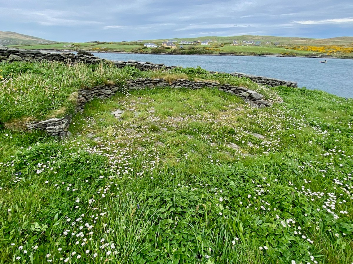
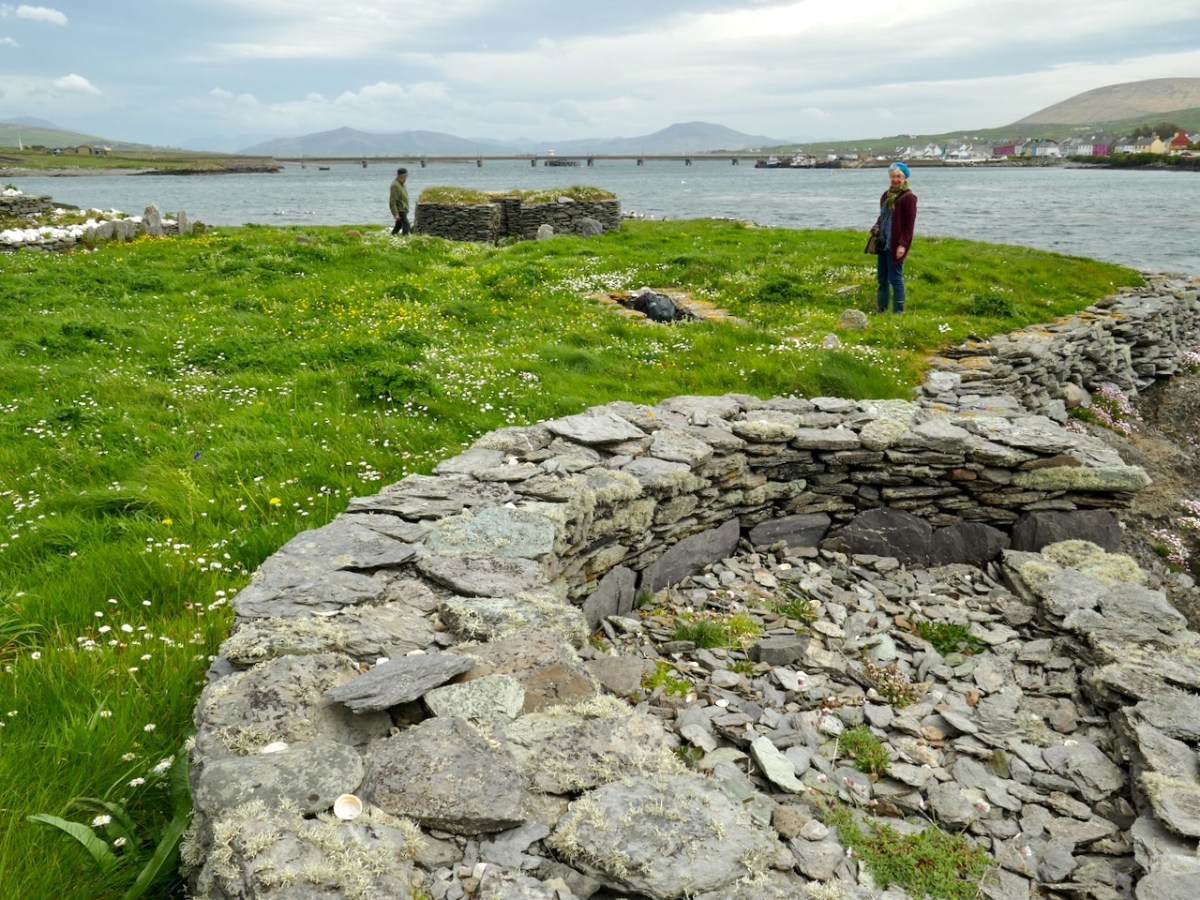
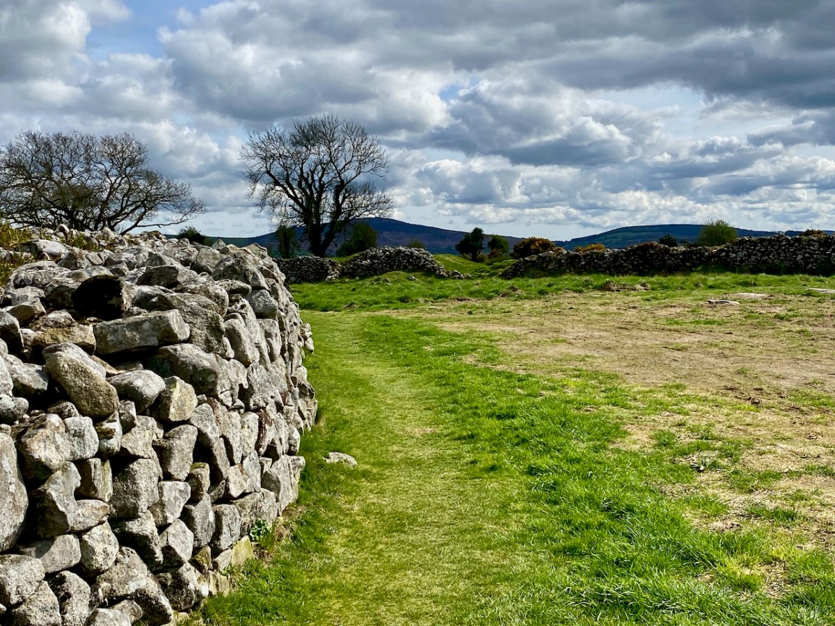
Further areas of worked stone marked out enclosures or terraced areas which would have had some significance to the community based there. After excavation, the island’s features have been returned to good structural condition. The site suffered some serious vandalism in fairly recent years. Fortunately, its general lack of access has provided some protection.

This felt to us a very special site, and we were privileged to be able to visit it. If you read the book about it, you will see that the thinking of those who carried out the excavations was that it was active from the 7th to the 9th centuries. In more recent times this dating has been questioned – possibly because radio-carbon dating results have been revised since those findings. It is now being suggested that use of the monastic site may have continued into the 11th century: we have to note that a Hiberno-Norse coin of 1020-35 was found under the paving of the plinth surrounding the gable shrine. White-Marshall and Walsh suggest this could be evidence for the use or maintenance of the shrine in the 11th century, while another commentator – Cormac Bourke (in reviewing the excavation report) – has suggested the continuous use of the site into that period.

For Amanda, the dedication of this site to a local saint would be important. Two saints named Lochan appear in the Martyrology of Tallaght (c. AD 800); one could have been the founder. It’s also worth noting that Saint Finnbar of Cork was baptised Lochan: he was educated at Kilmacahil, Kilkenny, where the monks named him Fionnbharr (white head) because of his light hair. His dates in any case do not fit with Illaunloughan: Finnbar was born around 550.

The island of Illaunloughan is low-lying, and at some risk of future indundation if climate change leads to drastic sea-level rise. We were fortunate to get the opportunity to visit this magical place, thanks to our local boatman – who bore us safely back to dry land!

PS Many thanks to Amanda ClarkeHoly Wells of Cork & Kerry – for dreaming up this remarkable adventure. And for finding us a boatman!

Sugar Loaf

We were unexpectedly in County Wicklow, and had a day or two of sunshine. To take advantage of this, we found our way up to the Great Sugar Loaf, with every good intention of climbing to its peak – 501 metres above sea level. I’ll come clean and mention that the starting point for the walk is already halfway up this elevation – and also we didn’t make it all the way on this occasion, as we were heavily overdressed! Only yesterday we still seemed to be in the grip of a very harsh winter, so had assumed that gloves, scarves and thick jackets would be the order of the day. In fact, quite a few other climbers were clad in tee shirts and shorts…

The upper view was taken on the path going up to the top – this morning. The lower view – taken a couple of years ago from Bray Head – gives a good impression of the Great Sugar Loaf (the furthest peak on the right) as the high point in a range, rather than a lone conical summit. There is also a Little Sugar Loaf which – in this view – is the high point in the central range in the photo. From other places, the ‘Little’ loaf also appears like a conical ‘peak’. Have a look at the pic below, where I have tried to show both ‘cones’ in the same view.

This photo, which dates from the early 1900s, is taken from the old beach in Greystones: the Little Sugar Loaf is over to the left, while the ‘Great’ one is at the left end of the further ridge (photo by William Alfred Green (1870–1958) – courtesy of Ulster Folk Museum). Below – the same view of the two ‘sugar loaves’ taken from the Marina, Greystones, today.

Here’s another view of the ‘Great’ loaf, with further pics of today’s adventures below, including the prospects from on the hill:

The area deserves considerable further exploration. The extracts below are from the Schools Folklore Collection, recorded in the 1930s: valuable commentary and memories collected from local inhabitants.

. . . If we were to visit Kilmacanogue over a hundred years ago it would present to us a very different appearance from what it does now. Our journey would be by the end of the Sugar Loaf Hotel of today, up the school lane, turning west for about a quarter of a mile and crossing the present day Rocky Valley road and following in a south-western direction along the foot of Sugar Loaf mountain. On our left was a church (in Brerton’s Garden) but not even the ruins of this remain. It is said the monks fled from this church in the Penal days, burying behind them their gold chalice, which still lies hidden in the field still know as the Church field. The road leading from Kilmacanogue to Kilmurry (now known as the Old Road) was the Coach Road between Dublin and Wexford. At the Kilmurry end there is a plot of ground about one acre known as Kilmurry Green which is believed to have been an old burial ground. The lane leading off from this road to the present main road near Kilmurry Dispensary locally known as Connolly’s Lane is supposed to have been lined with houses. The field on the North side of this lane (now in the possession of Miss Powell) is called the Street Field which indicates that a village must have been there at one time. The south part of Kilmurry Green contains the sites of two buildings – the stones, are still to be seen there, which marked the foundation of the gable. Traces of graves remain, though the place has not been used as a burying ground within any person’s memory . . .

Schools folklore Collection Kilmacanogue, Bray
Teacher: Caitlín Ní Chuinneáin

The Great Sugarloaf was a popular subject for artists. Examples are these watercolours: from Views of Bray and the Sugarloaf, County Wicklow, circa 1820 John Henry Campbell (1757-1828) – Whytes.ie. Back to the Schools Folklore Collection: we were particularly interested in the mentions of Red Lane, where there was evidently once a church, burial ground and holy well: it is said that none of these are visible today, but we will pencil in some further visits to have a closer explore.

. . . At the Southern extremity of Kilmurry bordering on Calary are two ruins which are popularly called Leghteampall or the Monasteries. These ruins stand in two adjacent fields, separated by a narrow lane (Red Lane). They lie east and west of each other in the Kelly’s and Whelan’s land, that in the west forming a square of thirty two yards each way. On the south side stands an angle of ancient wall built of stones and mortar 4′ 2″ high 2′ 2″ thick. There is a clump of stones and thorns at the north side 30′ long by 12′ broad and 2’2′ in height. There is an ancient holly tree in full vigour at the south-east angle a cross is cut in the tree and funerals stopped here and recited the prayers for the dead. About thirty yards east of there are the traces of an ancient church. A few stones of irregular shape remain in the foundation of the south wall; the stones appear to have been carried away from the north side within a comparatively late period. A heap of stones and rubbish occupies the place of the western gable, along which lies a large shapeless lump of a stone, having at the top a rudely formed cavity 7″ deep and 9″ in diameter at top, narrowing gradually to the bottom. This was a holy water stoup, one of the rudest ecclesiastical antiquities. An ancient decayed ash tree stands on the north of the church and graves may be traced in several places around it, though it has not been used as a burying ground for a long time. About a furlong south west of this place is a holy well called Bride’s Well (in Chapman’s Lane) at which Patrons were held, but none was held there within the last forty years . . .

Schools folklore Collection Kilmacanogue, Bray
Teacher: Caitlín Ní Chuinneáin

This winter scene is courtesy of Wiki Commons: we would like to visit at that time of the year, although the mountain may well not be hospitable then. Below – that’s the somewhat unusual gateway to the car-park at the Great Sugarloaf: take care when entering!

Rathgall Hillfort

Our journeys in search of important Irish archaeology can take us a long way from home. Today’s subject – the impressive Rathgall Hillfort – is located in County Wicklow, on the east side of the island. But it is well worth a long journey: its size is impressive – it occupies an 18 acre site. And the history of the place goes as far back as the Neolithic age. We visited on a brisk spring day, when the clouds were determined to contribute to our appreciation of this monument.

The size and longevity of this hillfort push it into a rare category. The substantial central rampart of stone walling is medieval, but the outer rings of stone and earth appear to have considerably earlier dates.

. . . Rathgall was a site of quite exceptional importance in the centuries spanning the birth of Christ, an importance that was clearly pan-European. The variety of structural information that the excavation yielded is unprecedented in the Bronze Age and the extraordinary concentration of artifactual evidence from the site has not been matched elsewhere in the country. Rathgall opens a wide range of questions concerning, not merely the nature of the Ireland’s later Bronze Age, but also the role of the hillfort in contemporary cultural developments . . .

Professor Barry Rafferty 2004

Plan of the hillfort and surrounding earthworks taken from the site notice board. Red lines indicate the site excavations. This board states that:

. . . Rathgall Hillfort is a hilltop settlement enclosed and defended by four concentric ramparts which can be dated to the early and middle Neolithic period . . . The outer three ramparts are stone and earthen banks and are likely to be prehistoric in date. Within the central enclosure there is evidence of metalworking, a cemetery and a round house; all dating to the Late Bronze Age . . .

The two photographs above are taken from the time of archaeological investigations which commenced in 1969. The results of those excavations, which covered a number of years, have yet to be formally published. [Late edit: Elizabeth Shee has informed us that the findings will be published this summer by Wordwell, through the work of Katherina Becker of UCC. Many thanks, Elizabeth, we will look our for that]. The investigations found evidence that this was the site of an important and busy Bronze Age factory for metalworking (axe and spearheads, swords) and for pottery, jewellery and glass beads. In total over 50,000 pottery fragments were found, as well as 3,000 bronze and gold artefacts.

Rathgall from the early OS map. The importance of the site was realised and kept in use by successive generations.

Our knowledge of the societies that centred their life on settlements such as these in Ireland is sparse: here, and elsewhere, we are left with evidence of their stone structures (which will outlast us) but also intriguing finds – the following quotations summarize some of Professor Rafferty’s work here (courtesy of Rath Community Group and The Heritage Council):

1969 – 1971 . . . It took over 3 years to dig out the entire 15 metre wide section of the inner circle. Within an hour of starting work, he [Professor Rafferty] had located pottery pieces. Over 10,000 finds were from the inner circle; glass objects, clay moulds, stone and gold objects. Post holes indicate that there was a small house-like structure within the circle. The ditches were filled in with black material among the stones. An oval pit was discovered near the centre of the house. It had a carefully placed large boulder on top of black material almost covering the pit. The pit had been back filled in with yellow clay around the boulder. When the black clay was taken out, they found a small gold-plated copper ring, 1 cm wide approx, embedded in burnt baby’s bones. They came to the conclusion that this was a ritual burial pit . . .

1972 – 1973 . . . They moved to the southern slope of outside of the inner circle and were getting 400 finds per day. Prof Rafferty got down to prehistoric levels after 1 foot in some places. This area was “jampacked with artefacts, glass, gold, animal bones, pottery and basket remains.” Rabbits had done a lot of damage and stones were removed by people over the years. They found hundreds of clay mould fragments embedded in a black clay-like substance. Clay moulds are always broken when found as they could only be used once. The moulds were made for swords or whatever was needed: copper was poured in and in order to get out the sword etc, the mould had to be broken. He found a smaller crucible with traces of lead in it, parts of blades of swords or rapiers, spearheads, cauldron legs but not the cauldron . . .

1974 . . . In Bronze age times people were buried crouched down in a foetal position and put in a clay pot. The remains of a female and child were discovered in such a clay pot at Rathgall, buried in a pit underneath large slab stones. Eighty eight glass beads were uncovered, which is the largest quantity found in any Bronze Age site in Ireland. These beads are 1 – 3 cm wide, mostly circular in shape, blue-green in colour and with a hole in them. This collection is unprecedented in the late Bronze Age of Ireland and is also one of the largest from a single site as yet discovered in Western Europe (Rafferty and Henderson 1987). Prof Rafferty found a 2cm twisted gold cylinder with its ends finely hammered and a dark green glass bead mounted in the middle, 2 – 3cm wide. Tiny delicate loops of gold were attached to each end. This is an object of great beauty and advanced technological expertise. He also found a metal disc with mercury gilding on it. Mercury gilding was used to stick gold to bronze. He got this piece analysed by the British museum and the piece was dated back to 1000 BC. Before it was analysed, the Irish professionals were uninclined to believe that this came from Ireland as nowhere in the world had mercury gilding been found that dated back further than 400 BC. Prof Rafferty felt that this emphasised the exceptional importance of the Rathgall site . . .

While visiting this site I was reminded of an adventure we had last summer in Northern Ireland. You’ll find it here. There we discovered The Giant’s Ring: that earthwork struck us as ‘gigantic’. But it only occupies an area of 2.8 hectares. Our latest exploration is over 7 hectares! That makes it Cyclopean, surely! While this Co Wicklow site has been examined by archaeologists, we certainly don’t yet have all the answers as to why it existed, nor do we know everything we would like to about those who built it. We just can’t help expressing a sense of wonder at this – and other – artefacts which have made their marks on our landscapes. We are grateful to those who have explored and labelled these sites, and also to those who make sure they are conserved for our future generations, who might find more answers than we do as to their origins.

Urban Dolmen

We are used to searching out archaeology in the Irish countryside. More unusual, perhaps, is finding examples in an urban setting. Here’s one – at Cromlech Fields, Hackettsland, Dublin.

This particular example of a prehistoric structure has survived the encroachment of the city suburbs and is, in fact, in good condition and apparently accepted as part of the landscaping in a dense housing community. It is well-placed in a slightly sunken setting within a substantial green area. It is known variously as the Shanganagh Portal Tomb, Hackettsland Cromlech, or Ballybrack Dolmen. And it’s ancient: portal tombs can date back four or five thousand years – some even more. This arrangement of stones has seen civilisations evolve significantly, but it sits there unchanged.

The historic 25″ OS map of Ireland – surveyed from the late 1890s and into the early 20th century. It is clear from this edition that the ‘dolmen’ was still sited in open country at that time.

Illustration from: A Hand-book of Irish Antiquaries by William F Wakeman, 1903.

. . . We cannot conclude our notice of this class of monuments without making some mention of the very interesting example remaining at Shanganagh, near the village of Loughlinstown, and not far from the ancient church of Killiney. Though inferior in size to several which we have already described, its dimensions are considerable; and as it remains, to all appearance, in its original state, the student will find it an object well worthy of his attention. The covering stone measures in length nine, in breadth seven, and in thickness three and a half feet, and is supported upon four stones. The highest part of the pile is nine feet above the level of the adjoining field . . .

William F Wakeman

You may want to be aware of the full range of portal tombs in terms of relative scale. Have a look at my post here from a few years ago: it features the largest of the Dolmens in Ireland (and, perhaps, in the world). That one provides challenges in terms of how it was constructed: the capstone, which has been raised on to supporting rocks, is estimated to weigh over 160 tons. Also, this post from Finola offers detailed information on these structures generally. Here is a nineteenth century view of how such monuments were erected:

Megalith or Monstrosity?

Some intriguing arrangements of stones here – and some enigmatic reporting of their significance as history. We are a long way from West Cork – in fact, over on Ireland’s east coast, among the fine estates of Killiney. We can’t help but search out examples of archaeology wherever we go, and a red dot on the Historic Environment map is always a good starting point, as is anything with an enigmatic name.

In this case, the red dot is just to the left of the ‘Pagan Temple’ at the top of the 25″ OS map – but look at all the other intriguing names in the locality!

Here’s a close up -extracted from the 1888 OS map, highlighting the site that we are looking at today. With Templeville, Druid Lodge, Druid Hill and Stonehenge as neighbours, the Pagan Temple demands a closer look!

It was last week’s subject – the writer and photographer Thomas Holmes Mason – who directed us to this County Dublin location. As a significant producer of picture postcards, Mason has left a large body of work, even though many of his photographic plates were destroyed in a warehouse fire in 1963. The National Library of Ireland houses a comprehensive collection, and I am grateful to them for this image, above, which shows an intriguing stone formation on the Killiney ‘Pagan Temple’ site. It is referred to as The Sun and Moon stone by some antiquarians, and the following description appears on the current Historic Environment Viewer:

DU026-010—-

Scope note

Class: Megalithic structure

Townland: KILLINEY

Description: “. . .This enigmatic structure is located within an area enclosed by a hedge on top of Druid Hill. In the E side of the enclosure are three irregular granite boulders that form a façade behind which is a larger boulder containing a setting of stones that form a seat. To the W of this are two large granite slabs set on their long axis. There are tool marks present. This structure appears to be a folly but it may incorporate the remnants of an earlier monument . . .”

Archaeology.ie Historic Environment Viewer

The Archaeology.ie write-up is accurate. In addition to the ‘chair’ (which Finola is elegantly modelling while trying not to sit in a puddle!) there are two further irregular granite boulders – but one of them (detailed in the T H Mason photograph) looks like two circles – hence ‘sun and moon’ – but is in fact a single boulder, here seen from the ‘front’ face:

The right-hand side of this stone has some marks carved on it (by human hand) – possibly part of a large circle that outlines this half, while the vertical ‘groove’, central to the boulder, also appears to have been chased out. It’s worth noting as well, perhaps, that there are two small holes drilled on the back face of this stone, one on each side but not aligned on any centre. Additionally, there is also a small hole drilled on the back face of the second stone:

This article – by William Wakeman – appeared in The Journal of the Royal Society of Antiquaries of Ireland December, 1896. It introduces an element of scepticism, which we should perhaps explore. The excellent Killiney History website has collected together a number of writings and observations about this site.

John Dalton writing in 1858 seems quite satisfied of the antiquity of the Judgment Seat. The Gazetteer of Ireland states “A well-preserved Druidical circle with its priests’ seat and its sacrificing stone, occur within a carefully kept enclosure, behind Mount Druid demesne, and near the Martello Tower, but is made accessible by the proprietor to respectable visitors.”

Killineyhistory.ie

William Wakeman, a well known antiquarian of the last century, appears to have been the first to condemn these remains as spurious. “Formerly it was enclosed within a circle of great stones and a ditch. The circle has been destroyed and the ditch so altered that little of its original character remains. The seat is composed of large rough granite blocks and, if really of the period to which tradition refers it, an unusual degree of care must have been exercised for its preservation. The stones bear many indications of their having been at least rearranged at no very distant time. Small wedges have been introduced as props between the greater stones. The right arm is detached from the other part, to which it fits but clumsily. The whole, indeed, bears the appearance of a modern antique, composed of stones which once formed a portion of some ancient monument.”

Killineyhistory.ie

These photographs were taken by William Frazer in 1898. The arrangements of stones at that time are very similar to what we see today – well over a century later – but with far less growth of ground cover.

Above: Druid’s judgement Seat, Killiney – from Library of Ireland archives.

Elrington Ball [1863–1928] confirms this view of the Druid’s Judgment Seat. The stones of which it is composed formed part of a Sepulchral memorial dating from very early times, consisting of three small cromlechs, surrounded by a circle of upright stones about 135 feet in diameter, and, at the time of its first attracting attention, in the 18th Century when everything prehistoric was attributed to the Druids or the Danes, it was assumed to be a Pagan Temple . . . Near the circle was discovered at the same time an ancient burying place, and some stones with curious markings, which are still to be seen. The burying place was of considerable extent, the bodies, which were enclosed in coffins made of flags, having been laid in a number of rows of ten each . . .

Killineyhistory.ie

Finally Woodmartin [Traces of the Elder Faiths of Ireland 1902 Vol 11] makes the sweeping statement: the entire structure leaves the unmistakeable impression of very modern fabrication, and it is a mere clumsy attempt to gull the public . . . As seen to-day these relics of antiquity present rather an unlovely picture, in an obscure and ill-kept corner, surrounded by an unsightly hedge, where weeds and brambles share their ancient sanctity; they seem to arouse but little interest . . .

Killineyhistory.ie

Today, the jury seems to be out on what we are looking at on this site. Time has undoubtedly changed the shape of things: wouldn’t we like to go back a while and see the burying place of considerable extent with all those . . . bodies, which were enclosed in coffins made of flags, having been laid in a number of rows of ten each . . . ? But we do appreciate that a former landowner must have donated the land to excite our interest!

A good tailpiece from William Wakeman

Mason’s Islands of Ireland

We’ve had a book on our shelves for years, and it has been overlooked: The Islands of Ireland by Thomas H Mason.

Here’s the wonderful cover, and anyone who knows their books will be aware that it’s published by Batsford, and has a cover painted by Brian Cook. Our copy is well weathered, but still recognisable as the work of Cook: the graphics are very distinctive.

This is Brian Cook – in fact he is known as Sir Brian Caldwell Cook Batsford, and he lived from 1910 to 1991. He added the name ‘Batsford’ when he became Chairman of the publishing firm: his mother was a Batsford and his Uncle Harry headed up the firm for many years, although it had been founded back in 1843. Those of my generation will remember the very distinctive cover illustrations, all produced by Brian – with a mid-20th century style – and many still used to this day.

Another of Brian Cook’s book covers – showing the North Devon coast, not far from where I lived for many years. The Batsford Countryside, History and Heritage series included The Spirit of Ireland by Lynn Doyle (1939), and The Face of Ireland by Michael Floyd (1937). Many of the early books are now considered collector’s items, so we are fortunate to have The Islands of Ireland close at hand.

Brian Cook and his daughter, Sophie, in March 1970 (Evening Standard Library). Having had a quick run-down on the cover artist, let us now look more closely at the writer,Thomas H Mason: an article in the Irish Times – Oct 22 2003 – provides a background to the Mason family. They go back to the early 1700s and are described as ‘The oldest family business in the State’. When Seacombe Mason set up his own business at 8 Arran Quay, Dublin,

. . . His list of sale items included “telescopes, glasses, microscopes, concave and opera glasses, celestial and terrestrial globes of all sizes, electrical machines with apparatus – goggles for protecting the eyes from dust or wind, ditto for children with the squint . . .

Irish Times

The descendants of this early business – now Mason Technology – are based in Dublin, Cork and Belfast, but it’s Thomas H who interests us. Thomas Holmes Mason was born in 1877 and died in 1958, having moved the company into a new sphere. His grandson, Stan explains:

. . . In the late 1890s he introduced photography to the business in the form of picture postcards. We went on to become the biggest producer of picture postcards in Ireland, right up until the 1940s. My grandfather was interested in archaeology, ornithology, historical sites on the islands off Ireland, interests which brought him all over the country with his full-plate camera. He built up a huge and very fine collection of pictures which, unfortunately, were destroyed by fire in 1963 . . .

Irish Times

Examples of the photography of Thomas H Mason, also the header: views of Clare Island, Co Mayo. Initially, the ‘Islands’ book seems slightly disappointing: we would like to have seen something of the islands in our part of the west: Roaringwater Bay. But these do not get a mention!

Key: the map in the book, which covers islands in Mayo, Clare and Kerry. Perhaps a further volume might have set out to include the south-west? But – what Mason has given us is a fascinating photographic insight into life on the Blaskets when they were still inhabited; and sketches of the worlds of the Aran Islands and the Mayo islands from nigh on ninety years ago.

These two photographs show Clare Island during Mason’s visits in the 1930s. Note the castle, above, also included on Brian Cook’s cover painting. That is -of course – the headquarters of Gráinne Mhaol, probably better known as Grace O’Malley (1530 – 1603) – Ireland’s Lady of the Sea. But her story is far too long to tell here: she will have a post of her own in the future! Granuaile Castle overlooks Clew Bay, in Co Mayo.

The last image for today, from Thomas H Mason: Blasket Island Cottage. This is an invaluable record of a remote way of life: perhaps ‘timeless’ – apart from the clock in the alcove by the fireplace!

Look out for more from this writer and photographer – and more about ‘the Lady’ too!