Hail the Mail

Rossbrin wall box

The first act of the Irish Free State after independence was to paint all the post boxes throughout the country green. It was a brilliant stroke – royal red replaced by emerald green in one of the most visible and ubiquitous symbols of national administration.

Penfold Skibb

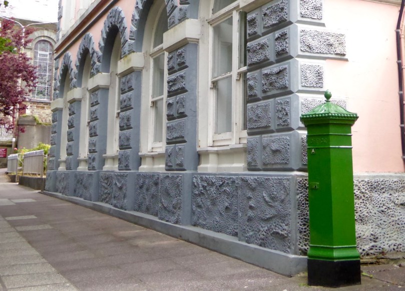
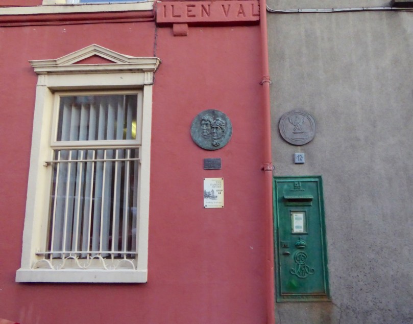
The Penfold post box in Skibbereen, one of only a handful left in Ireland

Ironically, the post boxes themselves did not change, so the royal insignias were simply over-painted by the new colour. The result was a charming mixture of tradition and adaptation that serves as an ongoing reminder of the history of Ireland and its institutions.

A commemorative sheet of stamps which are going on sale to mark 200 years since the birth of Anthony Trollope (Royal Mail/PA)

Special stamps issued by the Royal Mail in 2015 to celebrate the bicentenary of the birth of Anthony Trollope

The first post boxes were introduced to Ireland in the 1850s by the novelist Anthony Trollope, then a Surveyor for the Post Office. Trollope was happy in Ireland and wrote several novels and stories set here, although they are not the works for which he is most remembered.

Trollope Book Cover

We don’t usually think of Anthony Trollope as an Irish novelist but he lived here for almost 20 years, spent working for the Post Office and writing

One of the earliest models for a free-standing post box came to be known as the Penfold, after its designer, J W Penfold. They were manufactured and deployed from 1866 to 1879 and very few have survived in Ireland to this day – only six are known and of these only three are still in operation. Skibbereen has one of those, and very fine it is: one hundred and fifty years old and still in daily use!

Penfold Acanthus Leaf

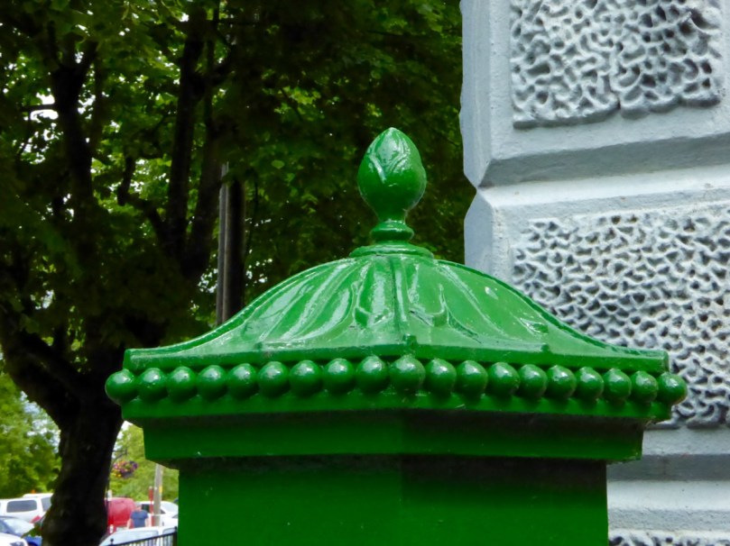
The hexagonal Penfold designed was apparently inspired by the Temple of the Winds in Athens (although the Temple is octagonal), with the addition of an acanthus leaf on the cap and a smart bud-shaped finial and beading.

BenQ Digital Camera

Photograph of the Temple of the Winds from Wikipedia

Our Skibbereen Penfold is in excellent condition: note the royal insignia and the entwined VR for Victoria Regina.

Penfold Skibb closer

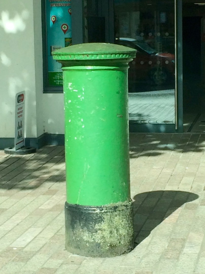
The Penfolds were replaced by round pillar boxes because there were too many complaints that the hexagonal design caused letters to stick. These cylindrical boxes can be seen everywhere in Ireland still, although mostly in towns and cities. The one below is on Grand Parade in Cork.

Cork Post box

Ferguson post box book

In his book The Irish Post Box, which I gratefully acknowledge as the source of much of the information in this blog post, Stephen Ferguson describes the three main types of post boxes that have been developed for use in Ireland: pillar, wall and lamp. In rural areas, such as West Cork, wall and lamp boxes are the most common forms I have encountered.

Skibb wall box

Here’s a representative wall box in Skibbereen. Interestingly, it’s part of a mini-complex of historical markers including the plaque to the Clerke sisters (see my posts From Skibbereen to the Moon Part 1 and Part 2 for more about these remarkable women and their family) and signs for the Skibbereen heritage walking trail, all mounted together on the wall of what was the main bank in Skibbereen during the Famine period.

Skibb post box

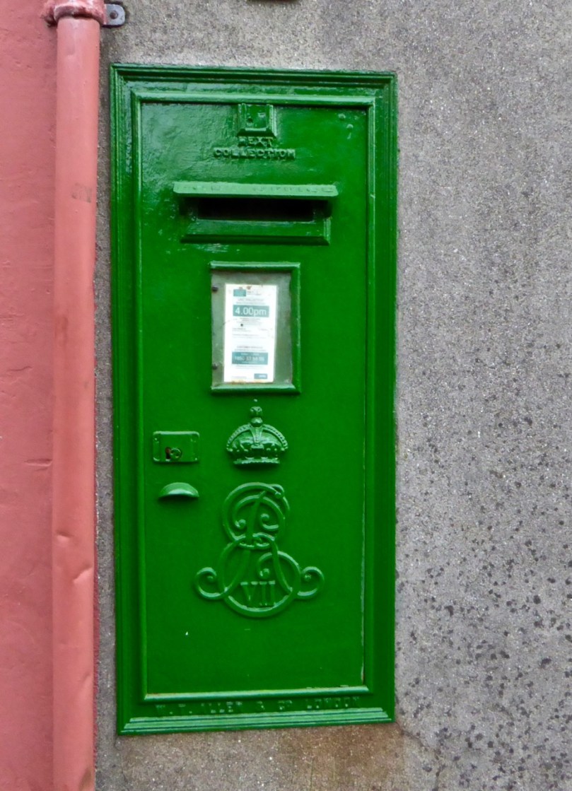
The box was manufactured by W T Allen and Co of London and bears the ornately scrolled insignia  and crown of Edward the VII, which places it between 1901 to 1910.

Bantry Wall Box

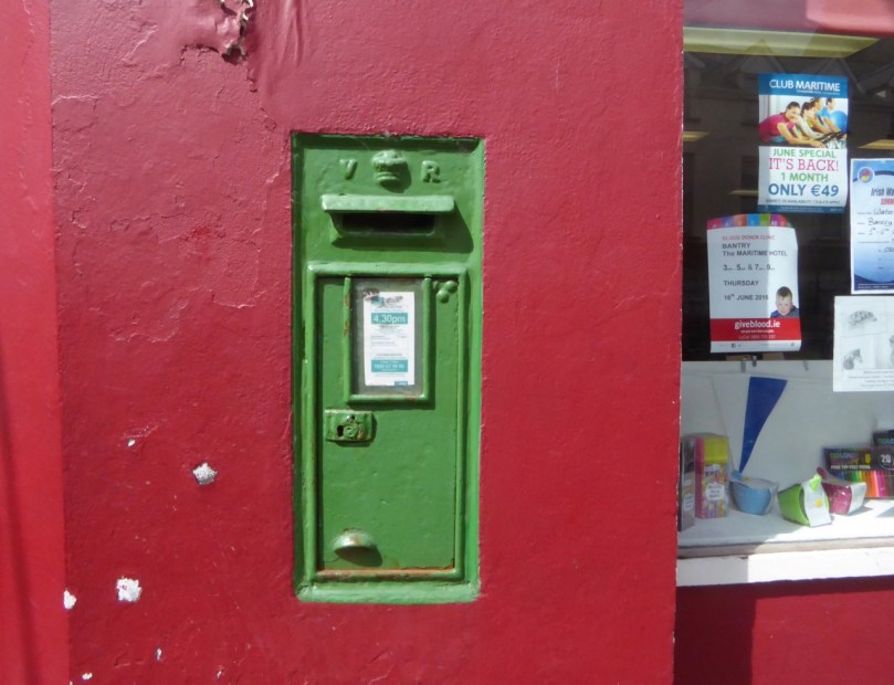
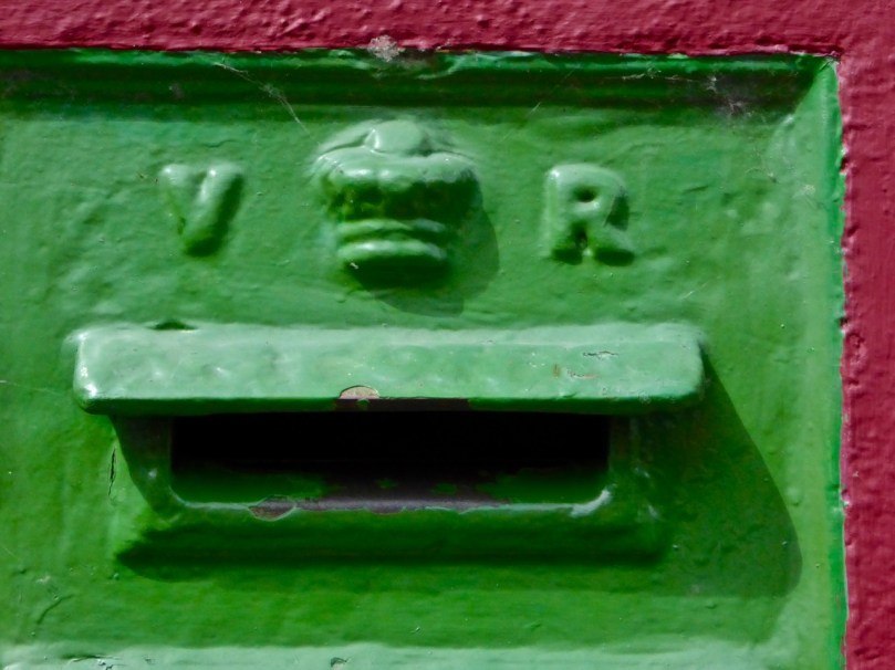
Here’s another nice one in Bantry, a Victorian one, although this time the VR lettering is simpler than on the Penfold. This one has been painted so often that the embossed POST OFFICE on the protective hood has almost disappeared under the layers.

Bantry Wall Box closer

Lamp boxes were designed for remote areas where a suitable wall might not be readily available. Ferguson explains: 

Lamp post boxes, based on a design used by the United States Postal Service, were first introduced in 1896 in London as a response to calls for more post boxes throughout the city. Affixed to a street lamp, the boxes were used at locations where the expense of a pillar or wall box could not be justified. In Ireland, however, they were often deployed in rural areas where, attached to a telegraph or specially erected pole by metal clips, they were very useful in extending postal collections to remote and sparsely populated regions. Tucked under hedges or used sometimes as a smaller version of a wall box, these post boxes were relatively cheap to make and easy to install and they symbolise…the extraordinary influence and reach of the Post Office as an institution at the height of its powers.

Post box near Barleycove

Driving or walking around rural Ireland, look out for ‘lamp’ boxes. Here’s one from the road near Barley Cove.

Pole Box near Barley Cove

Post_Box_P_T_SE_Washington_Street__Cork.
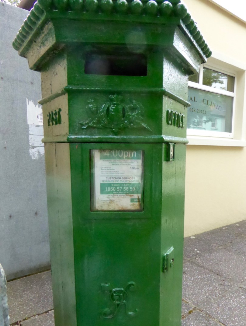
A closer inspection reveals this one bears the P & T logo that was in use between 1939 and 1984, before it was replaced by the brand ‘An Post’. Sometimes the old royal initials were ground off the boxes, or sometimes the doors were replaced with new ones bearing the P&T lettering, but it seems that considerations of cost (always paramount with the careful Post Office) allowed many to simply remain in place as they were. In the early years of the new state, some were embossed with the Saorstát Éireann logo (even sharing the door with a VR insignia) but that practice was relatively short lived and I have found no examples to it yet in West Cork. The website Irish Postal History has this example from Washington Street in Cork.

Most scenic postbox

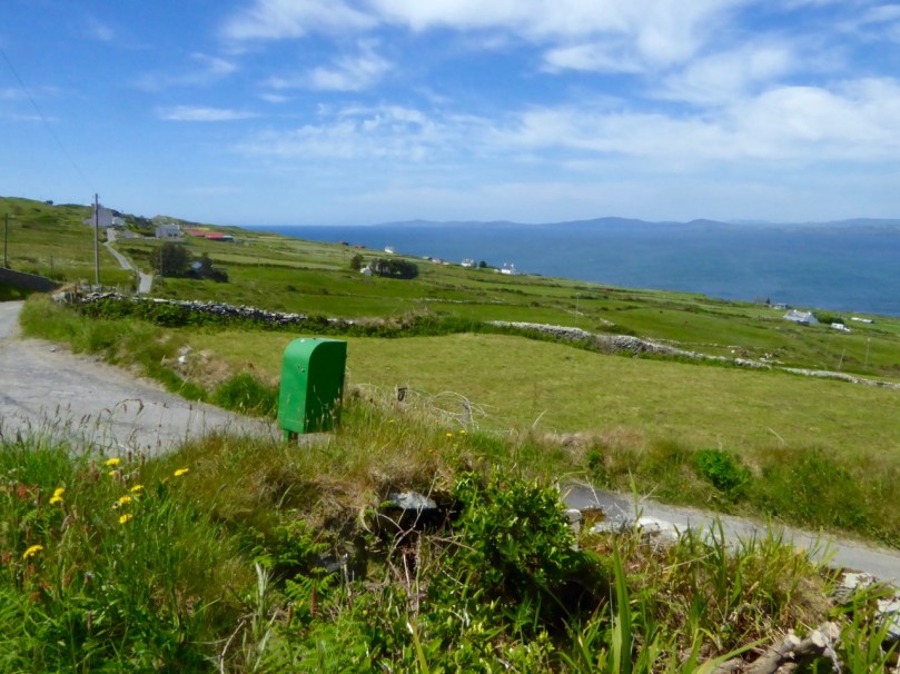
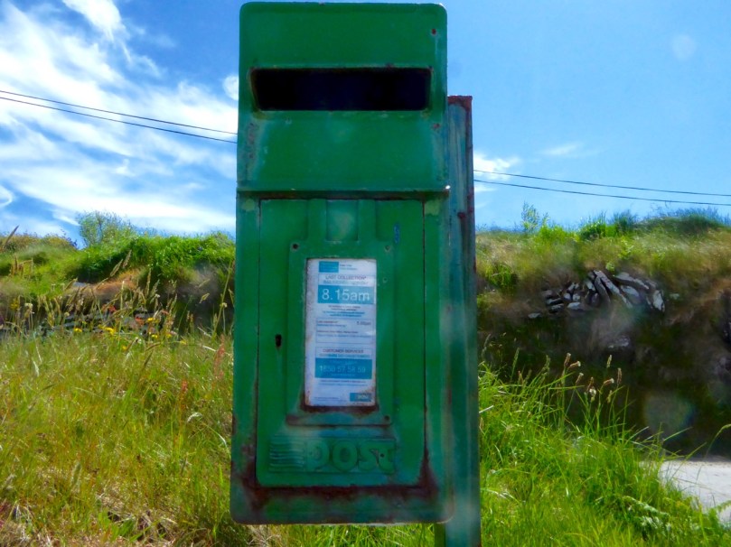
On Cape  Clear – the most scenic post box in Ireland?

If no lamp post or suitable pole existed, a simple stake was erected to which a box could be attached. Cape Clear Island didn’t get electricity until the 1970s, so this post box (above and below) must predate the advent of poles. The logo, however, is that of An Post, which was established as the new brand in 1984. Perhaps the poles were only erected island-wide after the submarine cable was laid in the 1990s.

Cape Clear post box closer

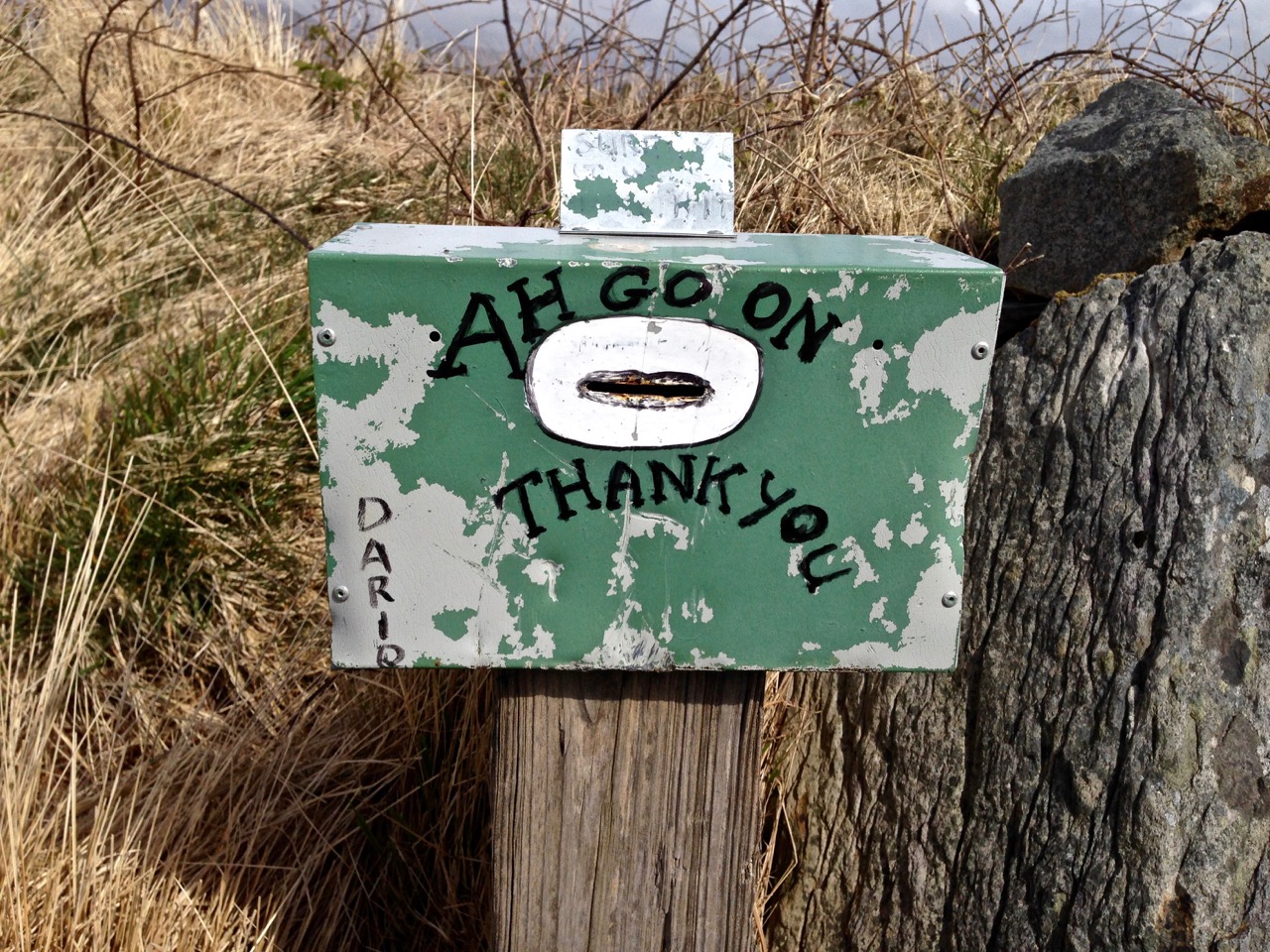
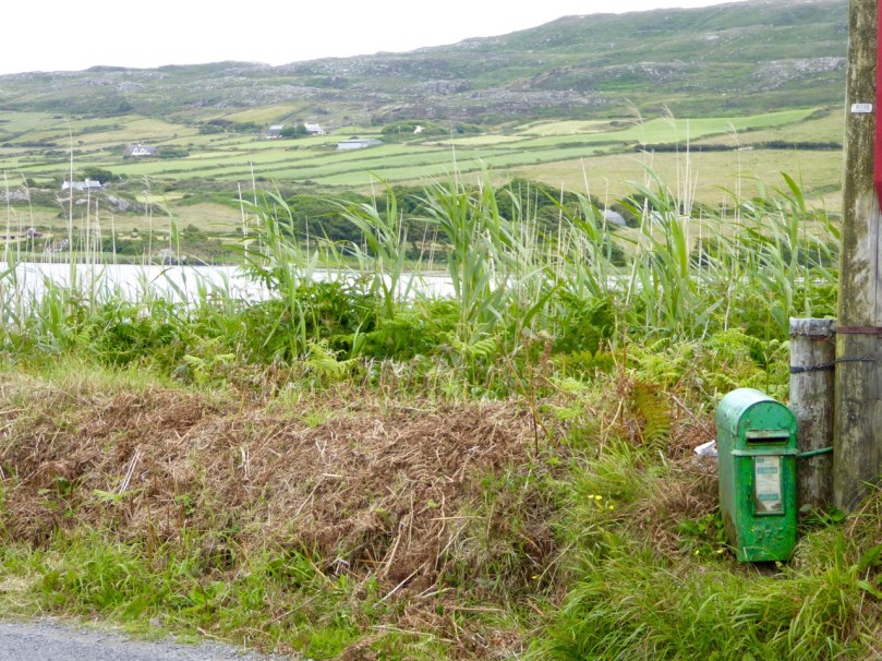
Not all mail boxes have been retained for active use – so what happens to them? Many simply remain in situ, as a picturesque reminder of times when we actually wrote to each other instead of texting or emailing. The one below at Rossbrin, near Ballydehob, was once attached to the wall outside the old schoolhouse. The first photograph at the start of today’s post shows its location.

Rossbring Wall box 3

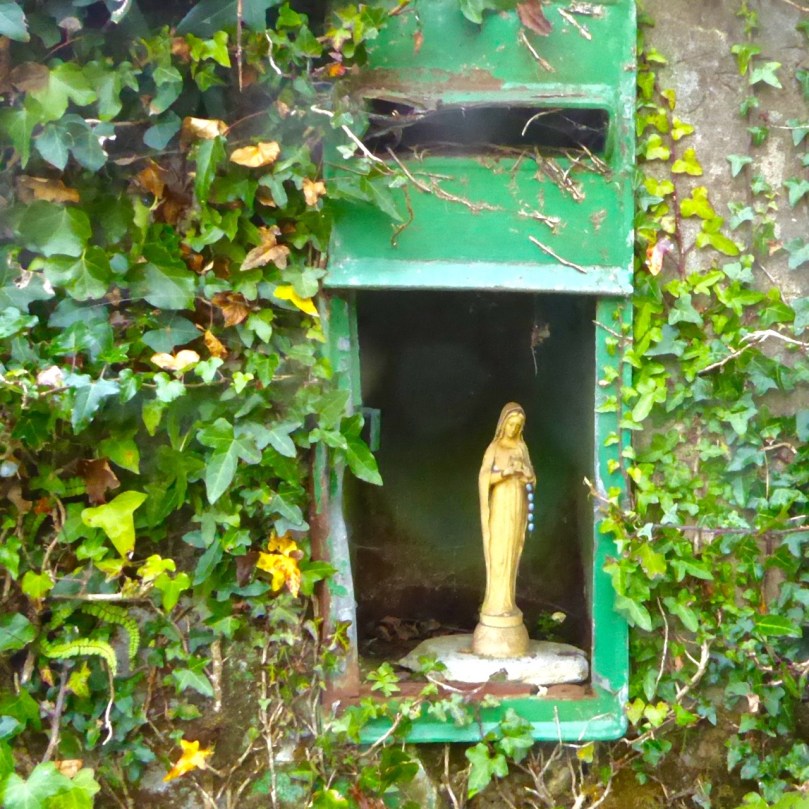
And this one, at Ahakista, has been repurposed as a wayside shrine.

repurposed

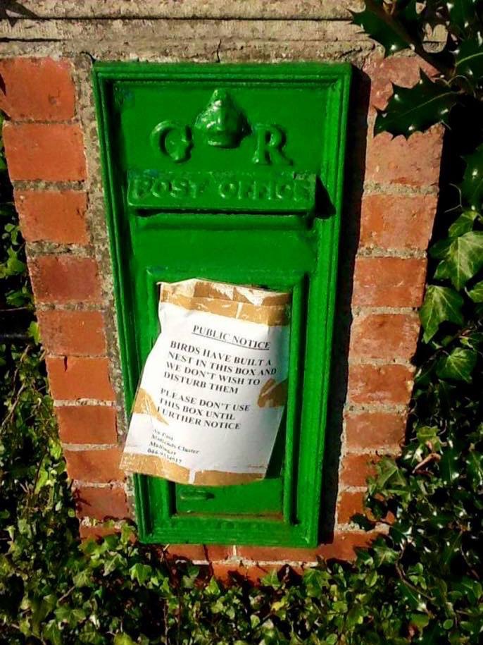
But even if it’s still in use, sometimes a mail boxes can’t be used for its real purpose, but has more important work to do! I don’t know where this last photograph was taken or whose work this is – it was widely circulated on the internet – but I would be happy to credit the photographer if I knew who it was. Delighted to have this also as an example of a post box from the reign of George V, 1910 to 1936.

Post box birds nest

Good Signs

Ah go on...

A collection of words (mainly) seen on signs around and about west Cork (and occasionally further afield) in recent times. They need no explanation. Enjoy them!

I have my own favourites; I’m always directing my own children to digest this one…

children and fathers

…And, lest we err, there’s always something to remind us:

no drink

Discovering Carrowmore

stone and sky

At the heart of the Coolrea peninsula in County Sligo lies one of the greatest megalithic complexes of ancient Ireland, An Cheathrú Mhór or Carrowmore as we call it today: the Irish name means ‘The Great Quarter’. Spread over a plateau of some 150 acres and centred on the high point of Listoghil are thirty recognisable tomb sites but it is suggested that there were once at least a hundred monuments here.

Carrowmore 1

The Carrowmore monuments that we know today cover over 150 acres: it’s likely that there is much more to this site which has been lost, or which remains to be recovered

The changing landscape has taken its toll: from the 18th century onwards land clearance and quarrying have damaged and obliterated many of the remains and even as recently as 1983 Sligo County Council sought to place a municipal landfill dump adjacent to the known sites. Fortunately a few alert local residents objected and took the case to the High Court in Dublin. Initially their objections were overruled but in 1989 an appeal to the Supreme Court was successful and the very important landscape context of Carrowmore has been saved, hopefully for all time. In that same year the state commenced purchase of a part of the site and has developed a sensitively planned visitor facility now run by the Office of Public Works. Since then more of the surrounding site has been purchased and is in public ownership.

stone and skyscape

Carrowmore landscape: this view to the great central cairn on Listoghil shows the nature of the terrain and the context of the monuments which it is so important to preserve

It’s the integrity of the complex that is so special here. The monuments found at Carrowmore are called boulder circles, though several have central dolmens or rudimentary passages. Generally around 12 to 15 metres in diameter, the circles contain 30 to 40 boulders, usually of gneiss, the material of choice for the tombs. Sometimes an inner boulder circle is also present.They are considered to be an early type of chambered cairn, or passage grave, though in fact, they may be the ancestor of a few monument types. This is the view of local man Martin Byrne, historian, artist, musician and our tour guide for the day. He pointed out to us how the passage of each of the boulder groupings is oriented, not towards a solar or calendrical event but to Listoghil, where an enormous cairn encloses a box-like stone chamber with a large capstone.

Monument, mountain and sky

One of the boulder circles at Carrowmore with its central chambered tomb. This view is looking away from Listoghil and towards another significant landscape feature, Knocknarea, which is topped by the cairn known as Queen Maeve’s Tomb, 6 km to the west. There are 6 more mountain-top cairns on the peaks of the Ox Mountains to the south. The central focus of the Carrowmore complex is the cairn on Listoghil, although this is not as dramatically visible as many of the surrounding cairns

The chamber on Listoghil has been given a modern context, with the original cairn covering having been cut away to allow access. This chamber displays the only examples of rock art to be found so far within the Carrowmore complex. This is hard to see in normal lighting conditions, but successive observations have enabled these images to be made:

Listoghil carvings Guillaume Robin 1994

The formerly covered central chamber of the Listoghil cairn: top left is a photograph taken during excavations by Göran Burenhult in 1996-98 – this shows three boulders in front of the tomb which are said to have been an earlier Neolithic monument displaced by the tomb construction. Top right is the OPW interpretation board for the chamber and above are drawings of the rock art on the edge of the roof slab compiled by Guillaume Robin

It’s startling to discover that the Carrowmore complex could be over 6,000 years old: carbon dating from some of the finds has suggested this. If so, then it’s the earliest of the passage grave cemeteries in use in Ireland. Many cremated remains have been found over this site (spread over a long period of time), although unburnt human bones were also recovered in the Listoghil chamber. It could be speculated that the focal point of Listoghil must have been the resting place of a very important person – or dynasty; we will never know for sure. 

‘Accidental’ rock art and rock scribing noticed on monuments at Carrowmore: these boulders have natural markings on them but it is possible that the monument builders were attracted by these marks, which may themselves have inspired carvings

The Carrowmore complex has been visible enough historically to attract the attention of antiquarians – which is useful for later archaeologists, as some parts which are now lost have been historically recorded, albeit using methodology which would nowadays be considered inadequate. Gabriel Beranger, who was born in Rotterdam in 1725, settled in Dublin in 1760 and was a notable illustrator of antiquities in Ireland during a long lifetime; he visited and recorded Carrowmore. A local landlord, Roger Walker, carried out some excavations of the tombs in the 19th century but made no significant records; it is suggested that he was a treasure hunter. George Petrie surveyed the site and numbered the tombs in 1837 but it was another 50 years before archaeologist William Gregory Wood-Martin made the first methodically recorded excavations. William Wakeman produced some exquisite watercolour sketches in 1879. More recently Swedish archaeologist Göran Burenhult undertook detailed studies between 1977-1982 and 1994-1998 and this work included the excavation and subsequent reconstruction of the Listoghil cairn.

Upper Left: the work of Gabriel Beranger who visited the area in the 1700s – this shows Queen Maeve’s Tomb on Knocknarea. Upper right: William Wakeman’s watercolour of Tomb 4 in 1879 (Sligo County Library). Above: Listoghil chamber tomb today

Our guide Martin has studied the complexes at both Carrowmore and Carrowkeel (a future destination for us) for many years and is imbued with the archaeology and the landscape. He gently pointed us to the fact that relationships can perhaps be seen between the profiles of some of the boulders – particularly the capstones of the tombs – and the more distant landscape. I find this fascinating: I have always felt, as an architect, that there should be a conscious designed relationship between any building that is erected by human endeavour and the setting of that building within nature. Could these parallels that we might be seeing at Carrowmore be conscious?

Dolmen and Mountain

Rocks reflecting nature? Were the capstones chosen to specifically echo the landscape context? A debatable – and very subjective – notion…

My day was made when I discovered that Martin was a musician – as is Margaret, and I joined them in their colourful house for a little session!

martin + margaret

Susan’s Burren

Valerian

Valerian provides a carpet of red in a Burren field

We want ‘A Susan Day’, we told her – and what a day we got! Readers may remember our visit (Showing off West Cork) from Susan Byron of Ireland’s Hidden Gems. We’ve been planning a return visit ever since, so that Susan could show us HER Burren. 

Fields of Stone

I’ve written about the Burren before – the unique karst limestone landscape full of heritage and wildflowers in West Clare. But this time we had the benefit of Susan’s intimate knowledge of the place – she lives there and has been exploring it for years. Since we only had one full day, she planned an outing that covered everything we love about this part of Ireland – you’ll see what I mean.

DESTINATION
Our destination: Turlough Hill

Leaving the car in a convenient spot, we set off up a long green road, Susan pointing out the wildflowers as we walked, here and throughout the day. We stopped at numerous places to admire features in the landscape: Corcomroe Abbey, for example, lay below us in all its medieval glory.

Corcomroe

Corcomroe – a wonderful site to visit if you’re in this area

Our first real stop was St Colman’s Holy Well. It’s a beauty, with all the remote wildness that lends such atmosphere to these ancient sacred spots. One of our blogging heroes, Ali Isaac of the wonderfully researched and entertaining site Aliisaacstoryteller had visited this same route a couple of weeks earlier. We were walking in her footsteps, although in reverse. She tells of her journey here and has extensive details about the holy well and St Colman here.

St Colman's well

St Colman's Well 2

Robert and Susan at Colman’s Well and a peek into the interior of the well

Ali had walked through the Burren in time to see the last of the electric blue Gentians that grow here and in the Alps. They were gone by the time we got there, but we were not disappointed in the wildflowers, which were everywhere underfoot in the most prodigal abundance.

Carpet of Orchids

Bloody Cranesbill, left, and a white orchid

Brilliant magenta Bloody Cranesbill jostled with delicate Orchids and tiny yellow Potentilla (or Cinquefoil), while Wild Thyme scented the air. One field was awash in Valerian. A rare Lesser Butterfly Orchid was spotted in the long grass and lovely Burnet Roses in a hedge.

Clockwise from top left: Burnet Rose, Lesser Butterfly Orchid, Mountain Avens and Spotted Orchid

Milkworth

Milkworth lurking in the grasses

Hiking up Turlough Hill was an excellent opportunity to see how the Burren is laid out. From below, it looks like bare rock, but as you ascend, you realise that the hills are stepped in a series of terraces, the evidence of retreating beach levels after the ice age. These terraces provide important forage for sheep and cattle, who, in turn, help in the regeneration of the plant life. The going isn’t easy – we didn’t stick to any defined path but simply clambered up the steep slopes. The flat parts had been deeply rutted by cattle hoofs – we had to be vigilant to prevent stumbles and ankle injuries.

Turlough Terraces

But the rewards were enormous – ever-increasing panoramas of North Clare, across Galway Bay and south into the hinterland.

Cattle enclosure?

We had an objective in mind. At the top of Turlough Hill, and most visible in arial photographs, is a prehistoric ‘village’ of over 150 hut sites and some larger enclosures. On the summit is an enormous cairn.

Turlough Hill

Turlough Hill 2

Hut site and cairn

From the top: An aerial image of the hut circles and cairn (look closely!)  from the National Monuments Service, a hut circle looking north to the sea, a hut circle looking towards the cairn

This mysterious site has been the subject of an initial investigation to establish the extent of it. The report had this to say:

Even though the hut sites, in a morphological sense, are domestic in character, it is very hard to see their role and function as primarily domestic, considering their location on this inaccessible and exposed hilltop. The activity that required the building of about 150 hut sites on this inaccessible and extremely windy summit, consisting mainly of bare bedrock, was most likely of a strong social and/or ritual character, with few direct links to secular way of life.

Susan on Cairn

This will give you a sense of how huge the cairn is

Earlier this year, Dr Stefan Bergh of UCG conducted a preliminary excavation within the hut-site concentration. You can read about that in this Irish Times piece. We saw the neatly back-filled trench, and look forward to his results.

Trench

Coming down, as all hikers know, is often more difficult than going up – the knees certainly protest! In this case, some chunks of it were accomplished by dint of sliding down on my butt and picking the thorns out afterwards. Oh – and the tick! Do check yourself after all walks in long grass where cattle and sheep have been grazing.

From the Cairn

The view from the cairn

We ended up at an early medieval site that quickly banished all thoughts of aching muscles – Oughtmama, of the Seven Churches. Meaning The Breast of the High Pass, there are actually only three churches at Oughtmama, but they pre-date the 12th century Cistercian foundation at Corcomroe, and as such they are excellent examples of early monastic structures in the Romanesque tradition.

Oughtmama Churches

There are several examples of churches built with ‘cyclopean’ masonry in Clare, and here at Oughtmama you can see the huge stones used in the courses of the outer walls that give it this name. Associated with St Colman (of the Holy Well) these churches probably fell into decline after Corcomroe was completed.

We hiked back to the car in the soft afternoon sunlight. It’s hard to believe that one day could be so packed with experiences. Thank you, Susan, for sharing YOUR Burren with us. We’ll be back – we’ll let you know when to put the kettle on again.

Wild Thyme

Wild Mountain Thyme