Sherkin Friary

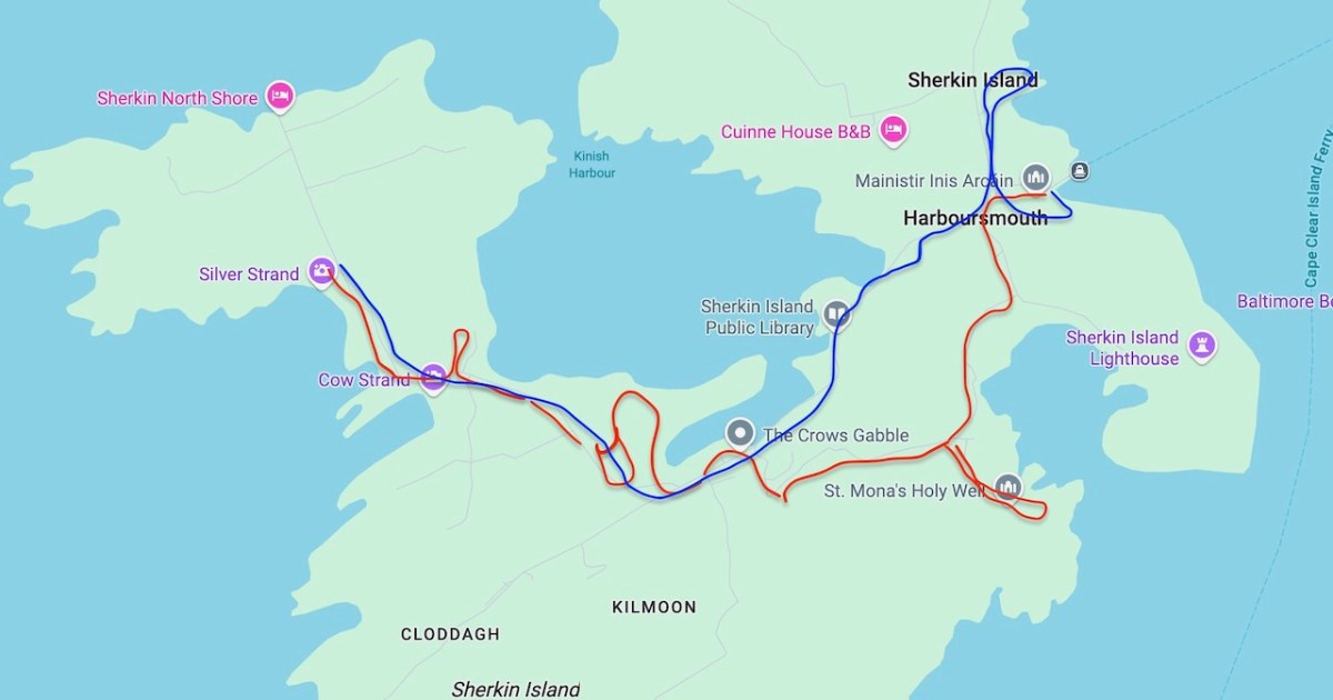
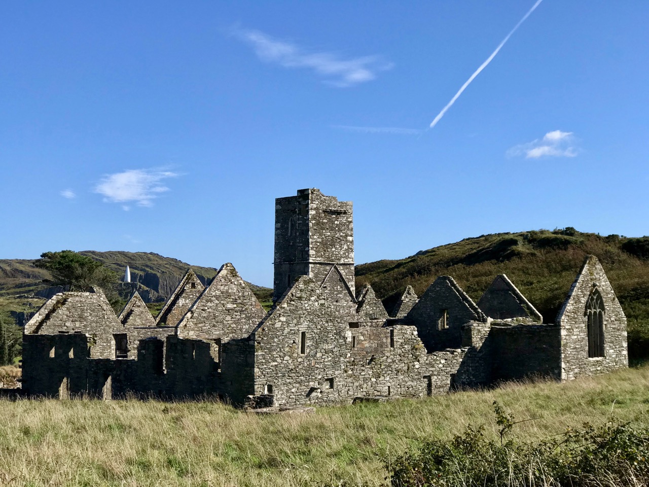
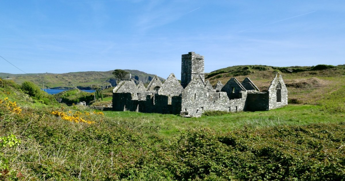
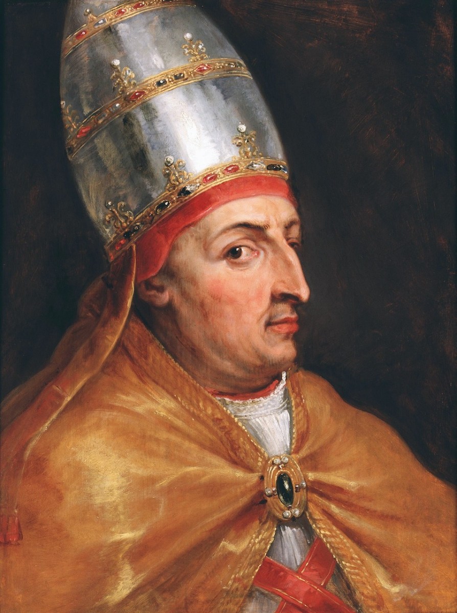
The Franciscan Friary on Sherkin Island (also called the Abbey) was established by Fineen (Florence) O’Driscoll, chief of the wealthy O’Driscoll clan, which had its headquarters in what is now Baltimore, but which, in the middle ages, answered to the name of Dún na Séad – Fort of the Jewels (how’s that for flaunting your wealth?). We know this because Fineen applied to the Pope himself for permission to found a friary. The Pope was Nicolas V, here seen in his portrait by Rubens. Although he was only Pope for eight years he was highly influential and responsible for many church innovations (such as the Vatican Library) and buildings (he started St Peter’s Basilica). He’s certainly giving Rubens the side-eye.

Ann Lynch, who excavated the Friary between 1987 and 1990 (source of much of the information below) tells us that Nicolas, despite being so busy in Rome,  

. . .in 1449, mandated Jordan Purcell, bishop of Cork, his dean, and a canon of Ross to license and to found a friary in his territory in honour of God, St. John and St. Francis. . . This reference is thought to refer to Sherkin Island (also known as Inis Arcain) and the licence explicitly states that the friars are to be under the jurisdiction of the Observant movement. There is no reference to building the friary however until 1460-2 when the  founder is given as Florence O’Driscoll.

The Franciscan Friary on Sherkin Island, Co. Cork, Excavations 1987-1990,

Ann Lynch, 

Journal of the Cork Historical and Archaeological Society, 2018, 55–127

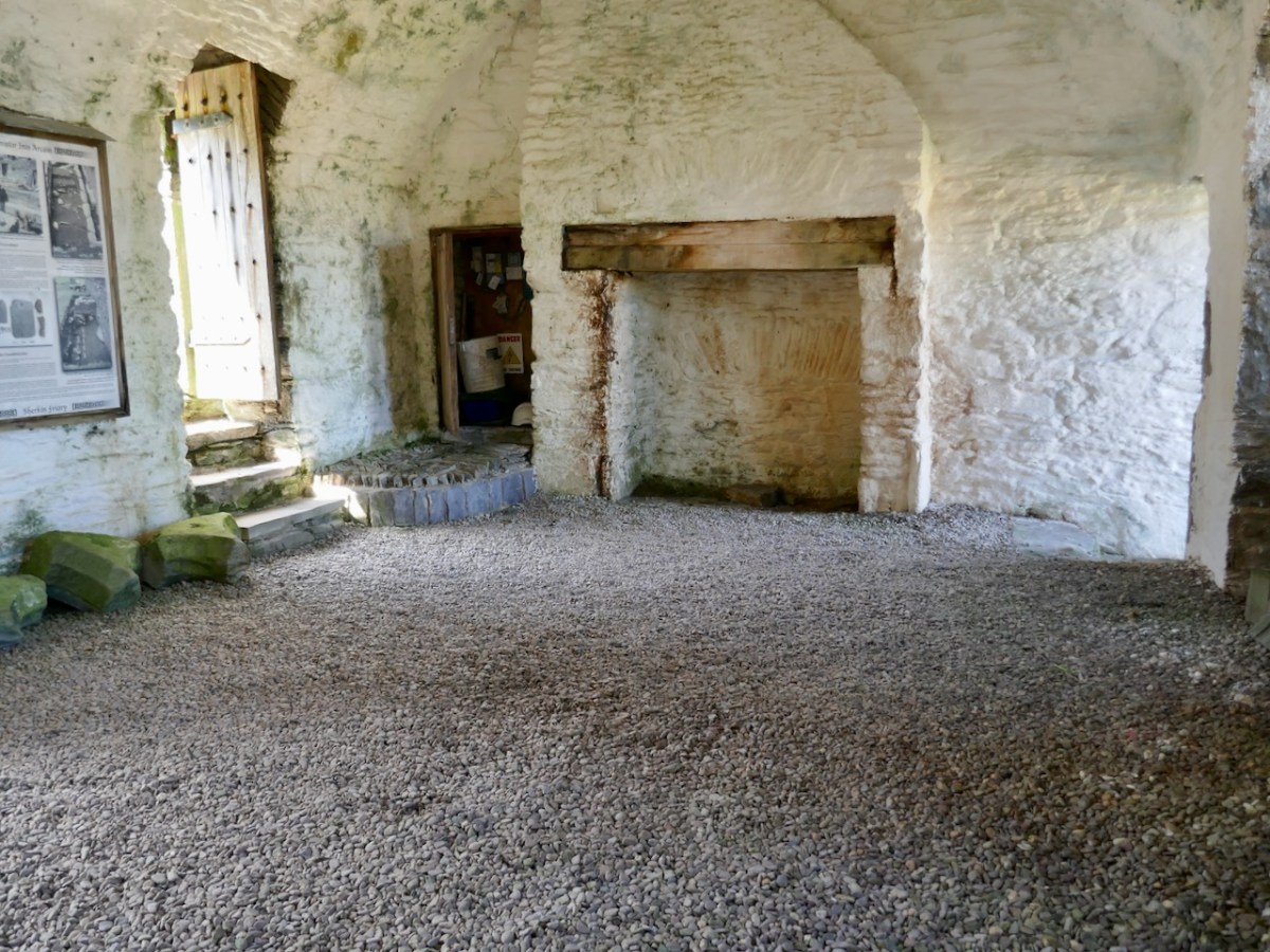
The Observant Movement aimed to restore the order’s focus on poverty, simplicity, and communal living as originally envisioned by Saint Francis. They did indeed seem to have lived a simple life – the only comfortable room in the place, and one use for communal living, was the chapter house, below.

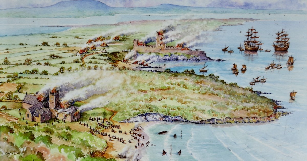
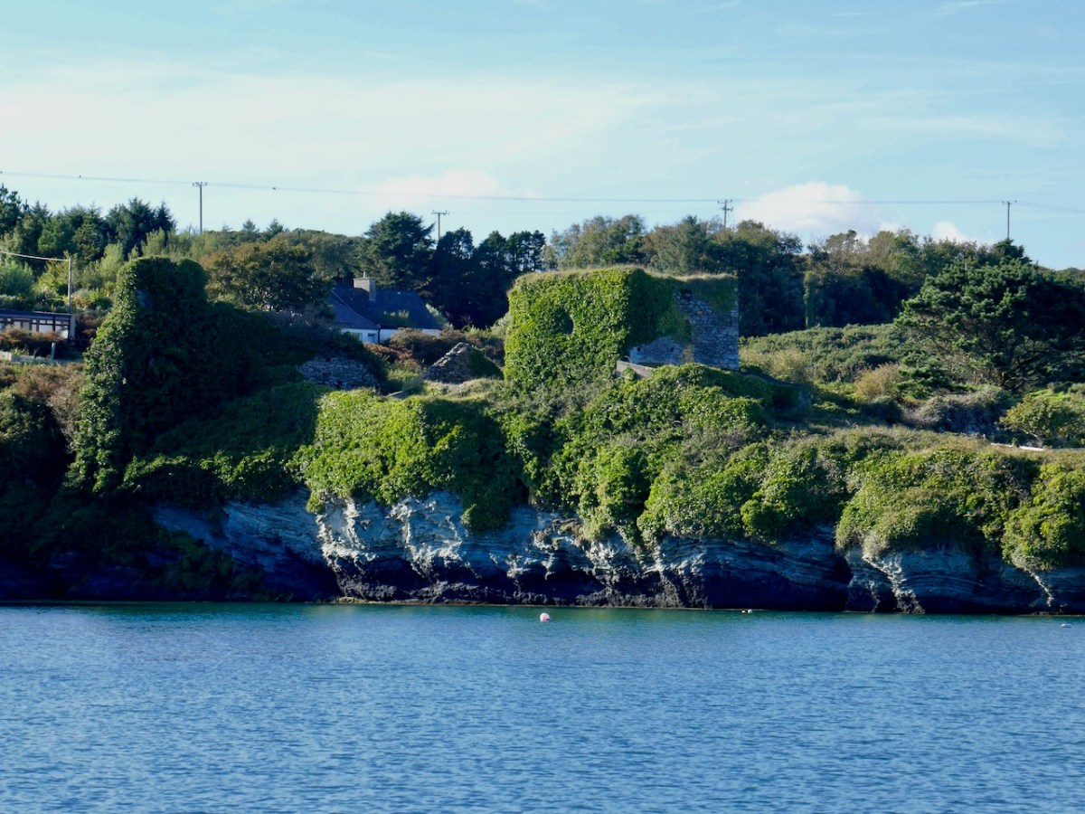
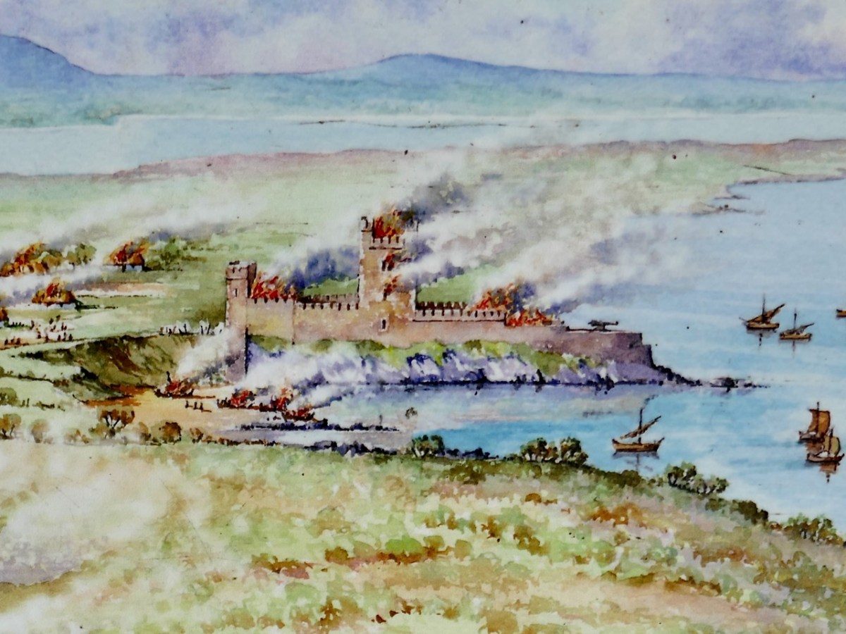
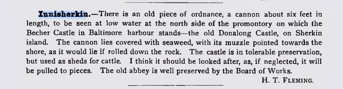
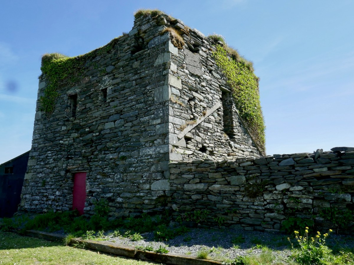
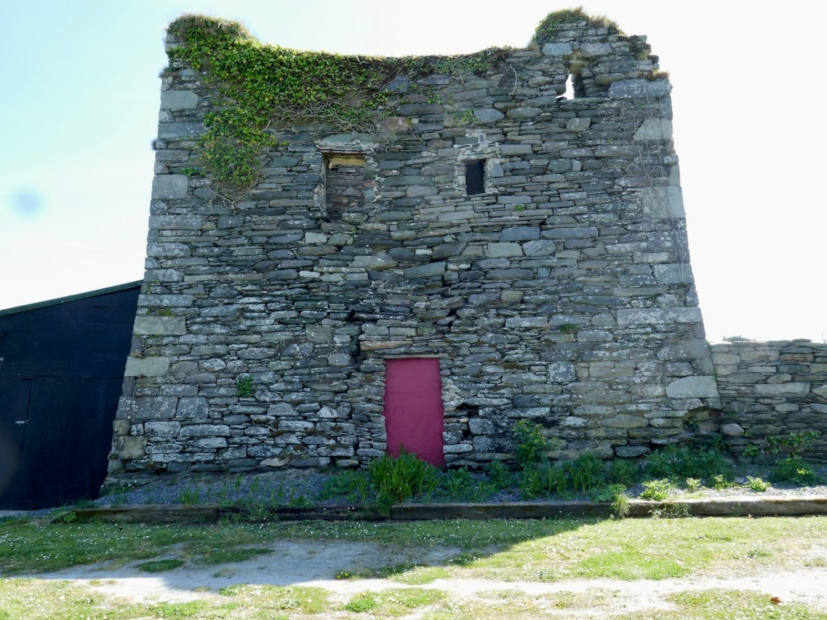
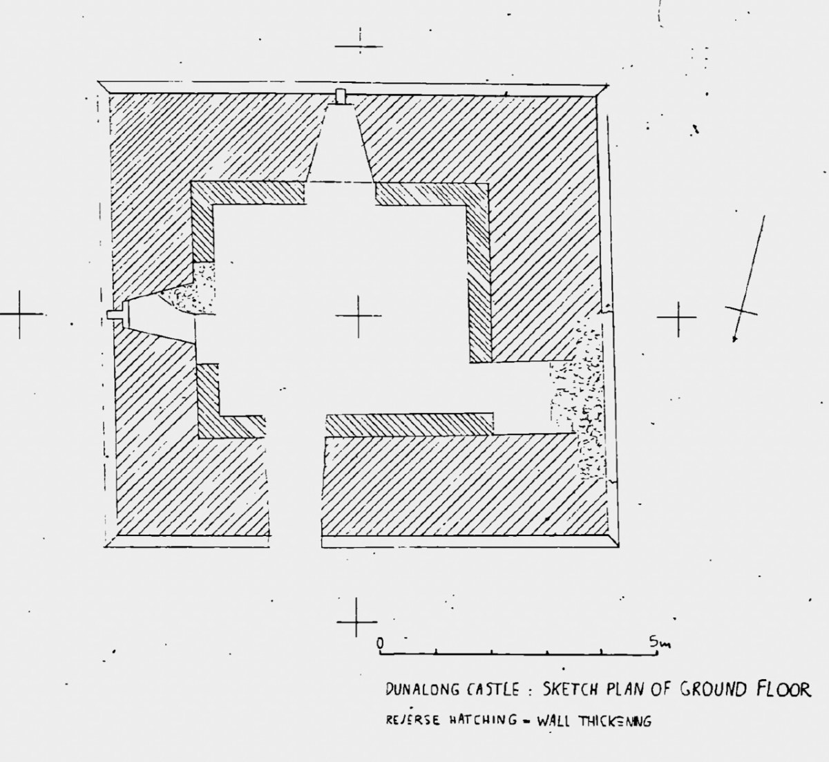
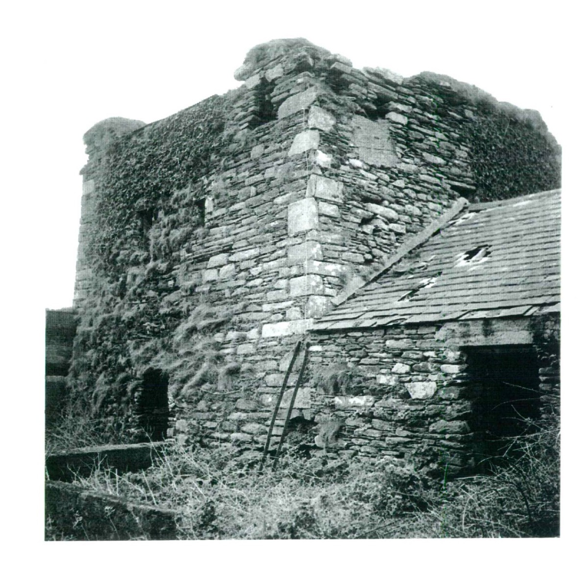
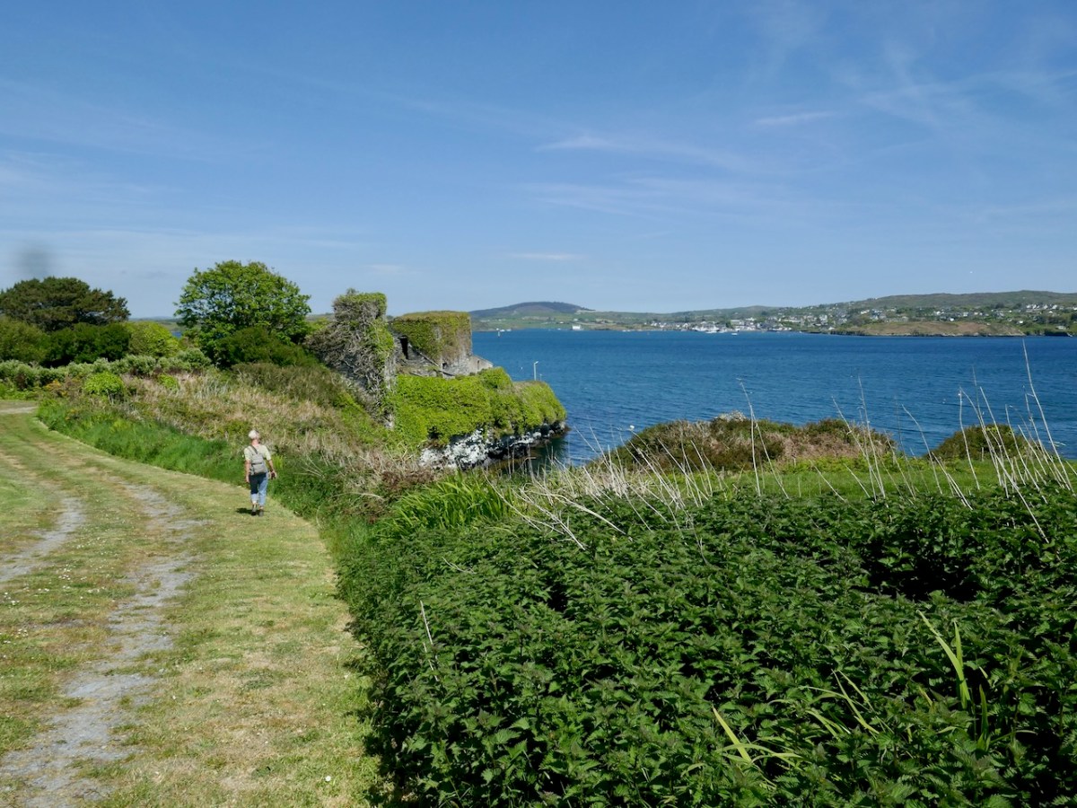
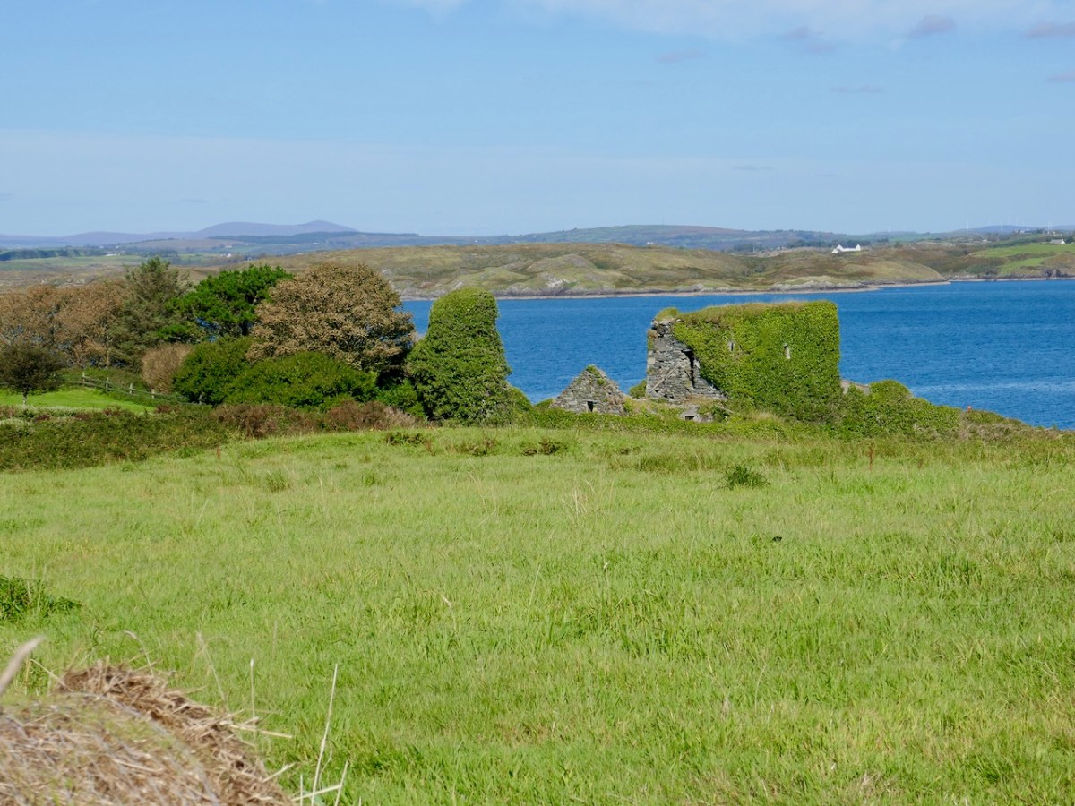
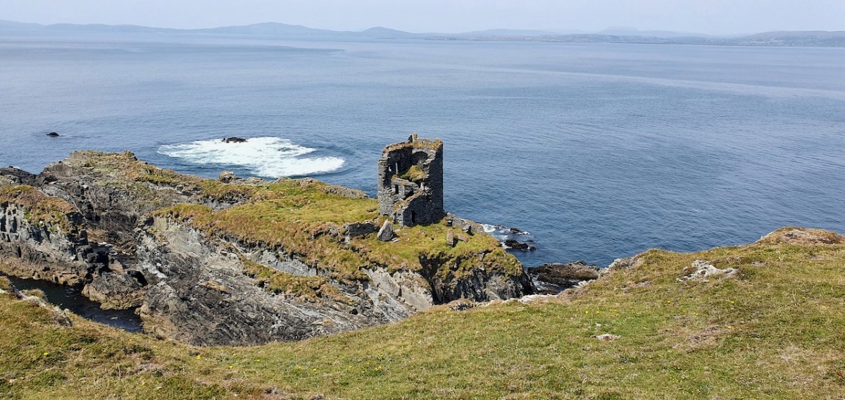
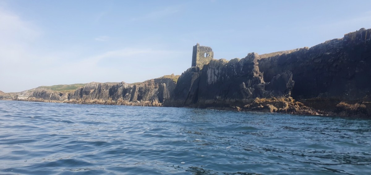
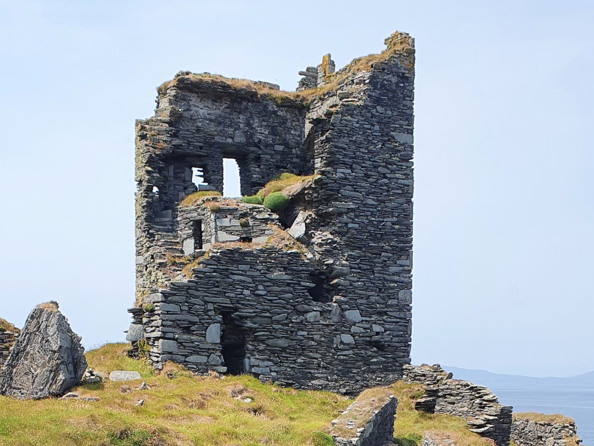
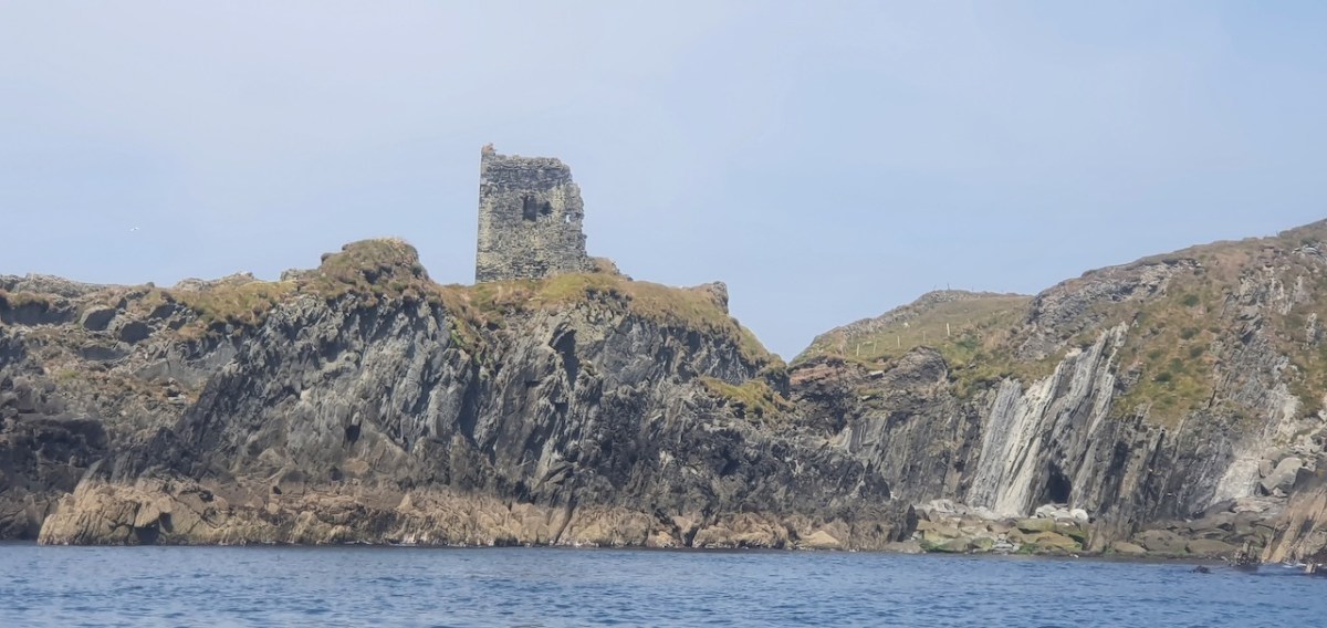
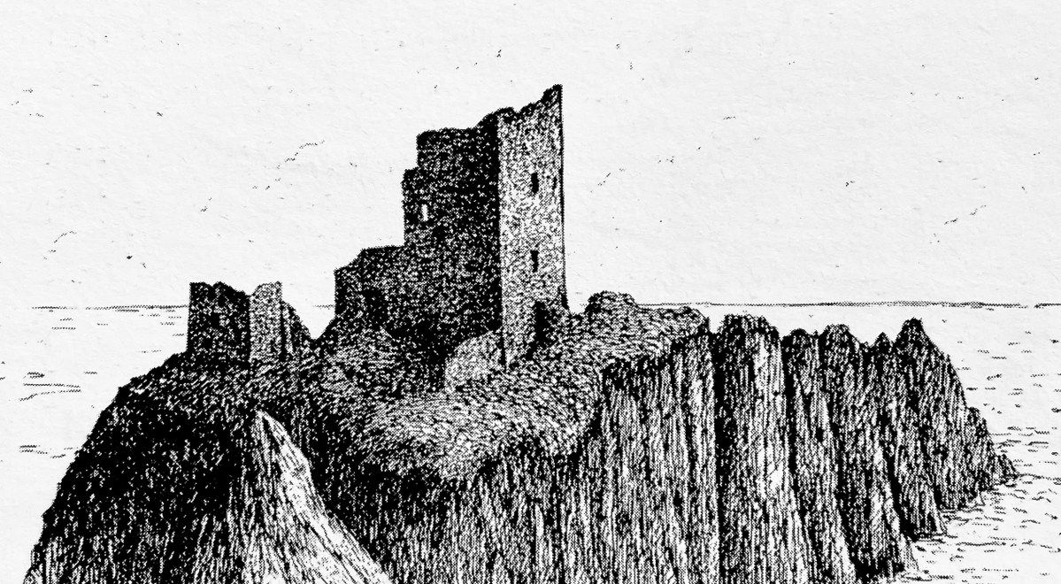
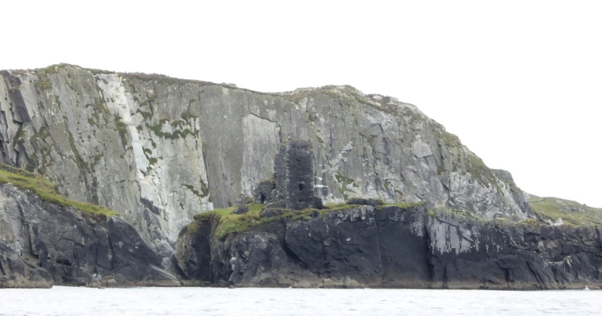
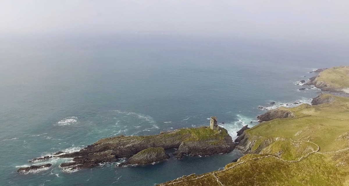
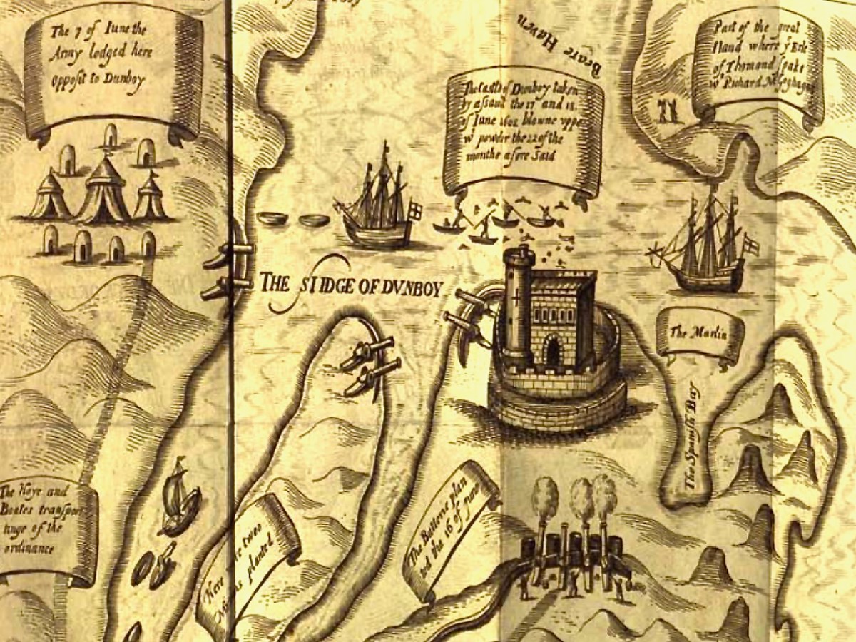
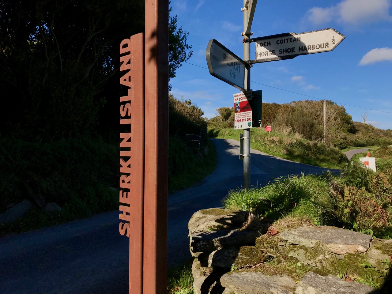
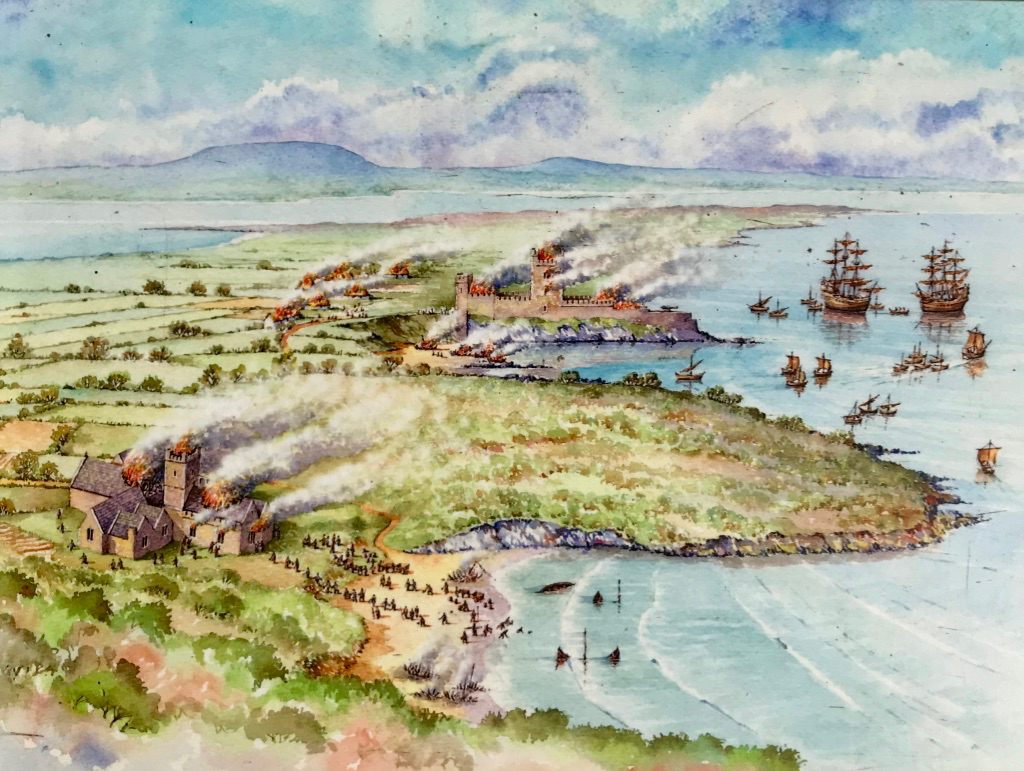
The siting of the Friary, close to Dun na Long Castle (see last week’s post) was not unusual in medieval Ireland, apparently. The castle was supposed to provide protection for the Friary, while the Friary afforded spiritual benefits to the castle inhabitants and the O’Driscoll chiefs. However, as we have seen last week, this didn’t go according to plan. The Waterford men sacked the castle in 1538 and plundered the Friary, setting it alight, and leaving it badly damaged.

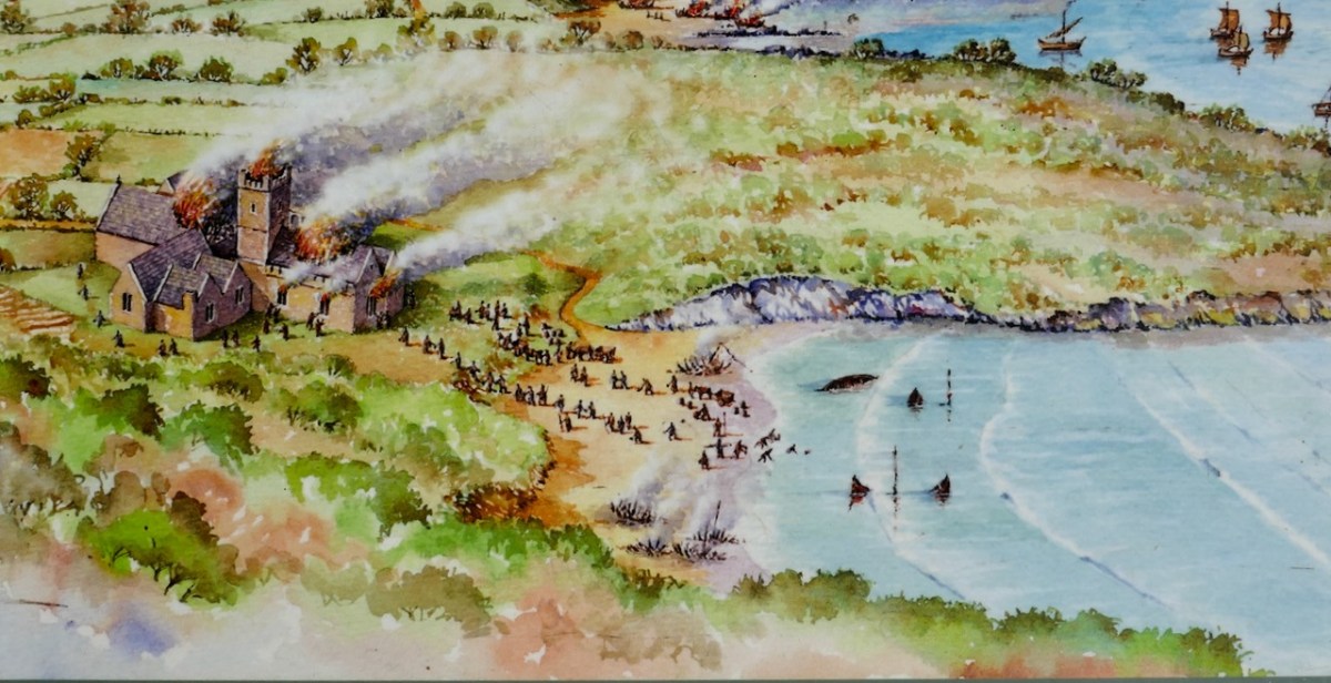
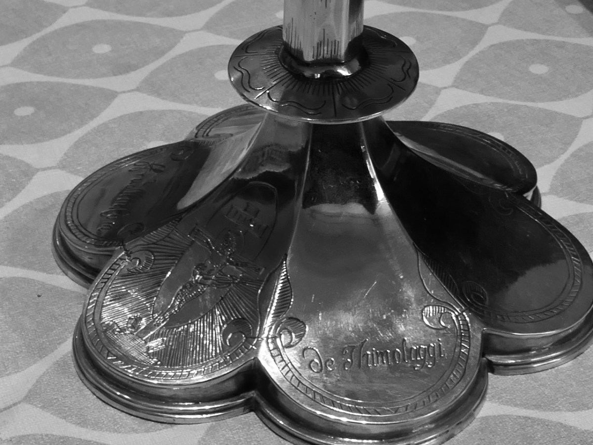
They also made away with the Friary bell, as well as some chalices and other valuables. Below is the base of the famous Timoleague Chalice, probably very similar to what was stolen. You can read the story of the Timoleague chalice here.

While the Friars fled for a while, they did return and lived at the friary until the last of them, Fr Patrick Hayes, died sometime after 1766. The Bechers took possession of it at that point and held on to it until they handed it over to the Commissioners of Public Works in 1892. It has been in the care of the State since then.

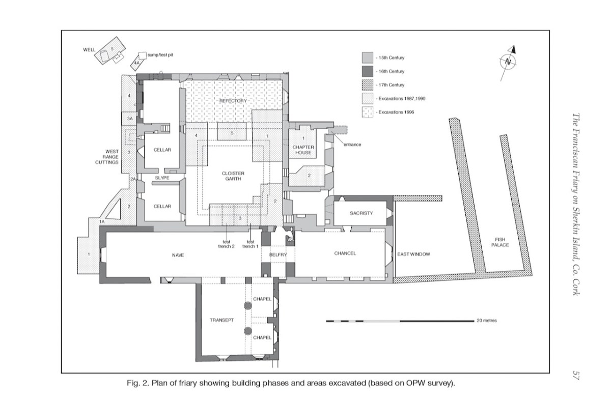
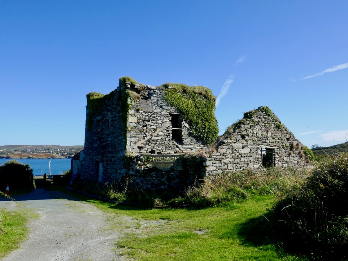
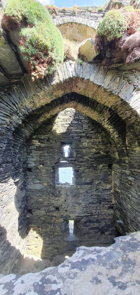
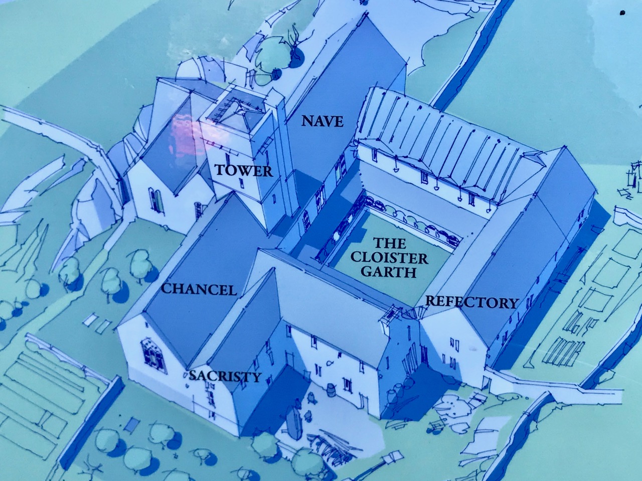
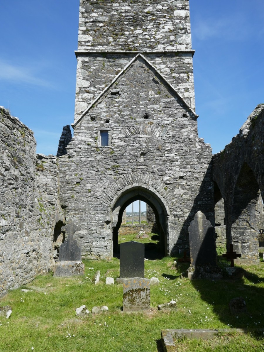
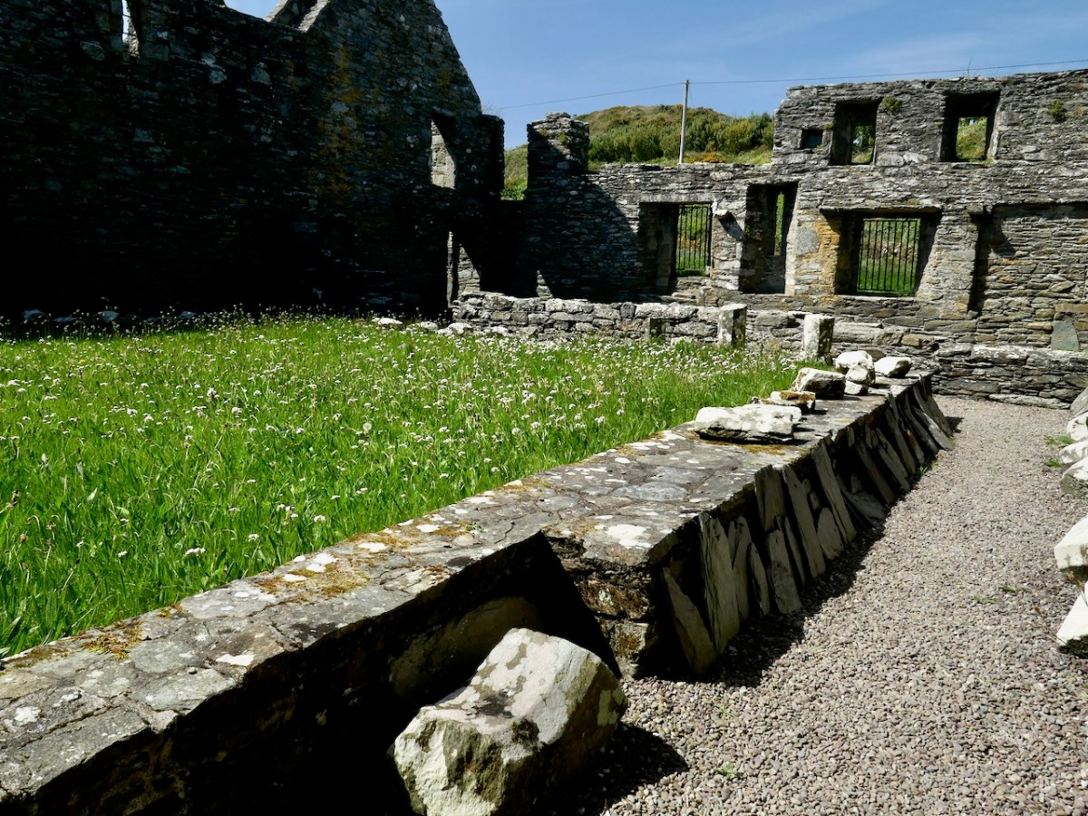
In form, the Friary is fairly typical of Franciscan houses in Ireland, with a long nave and chancel church, a bell tower, a cloister, side chapels, and a chapter house and refectory. 

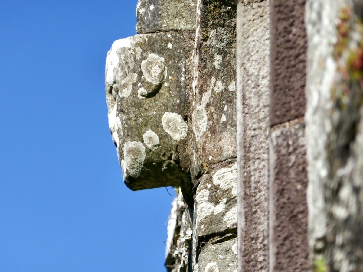
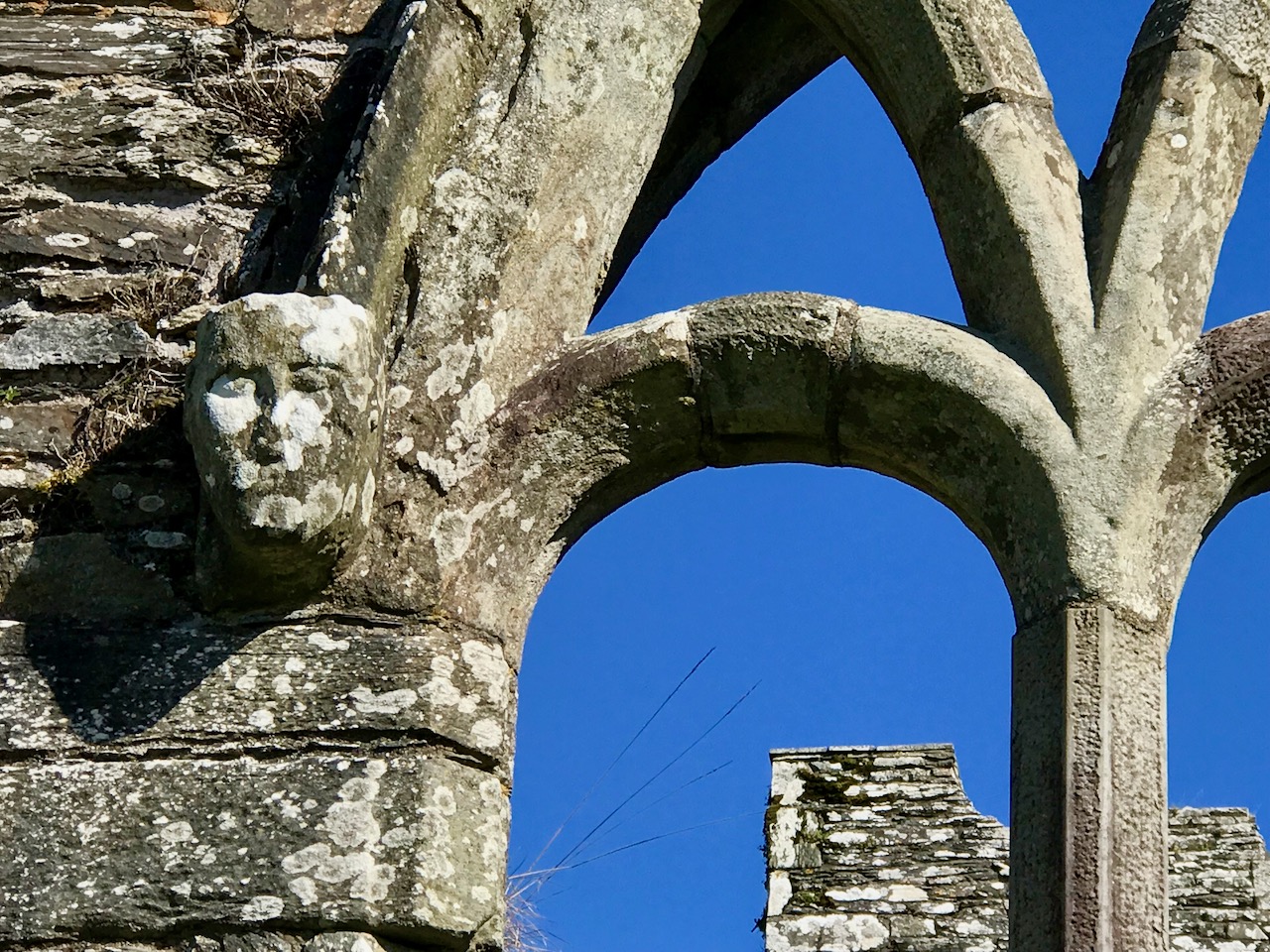
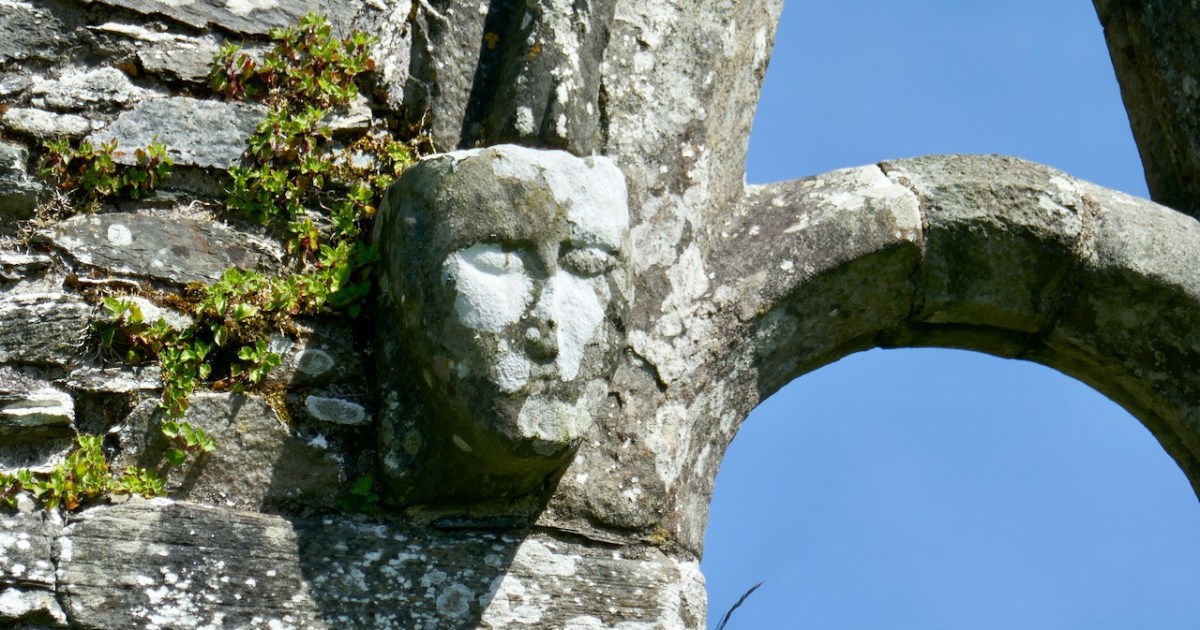
The nave and chancel run slightly north of east-west, due to the lie of the land. The West window has three lights and attractive tracery. We know that these would have contained stained glass, since fragments were found during the excavation, but we don’t know what they would have depicted. One of the charming features of this window are the heads – two still present although the one at the apex is too worn to make out, and a third indicated by a gap at the base of the hood moulding.

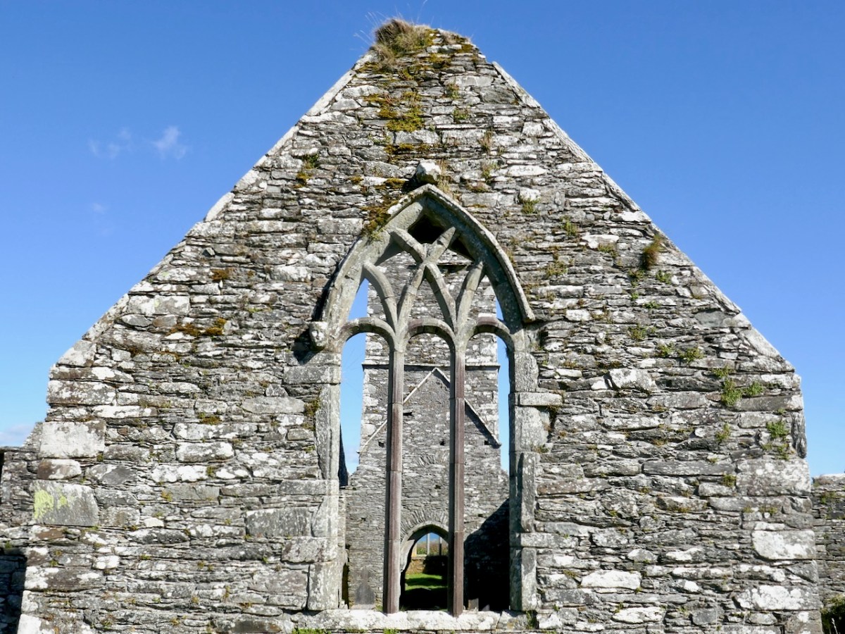
I am tempted to see a female saint in  the one head that is still fairly complete. After all, St Mona is the patron saint of Sherkin, so why would it not be her?

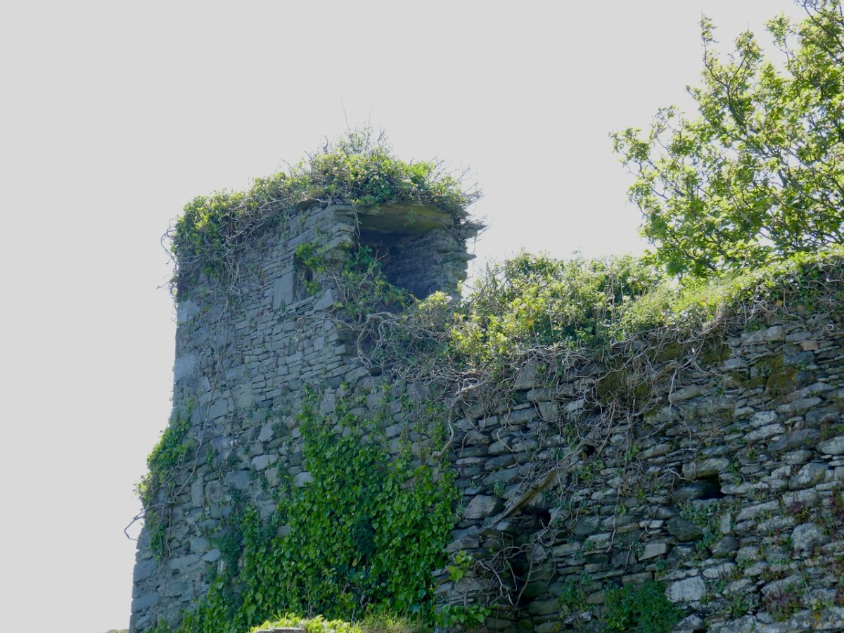
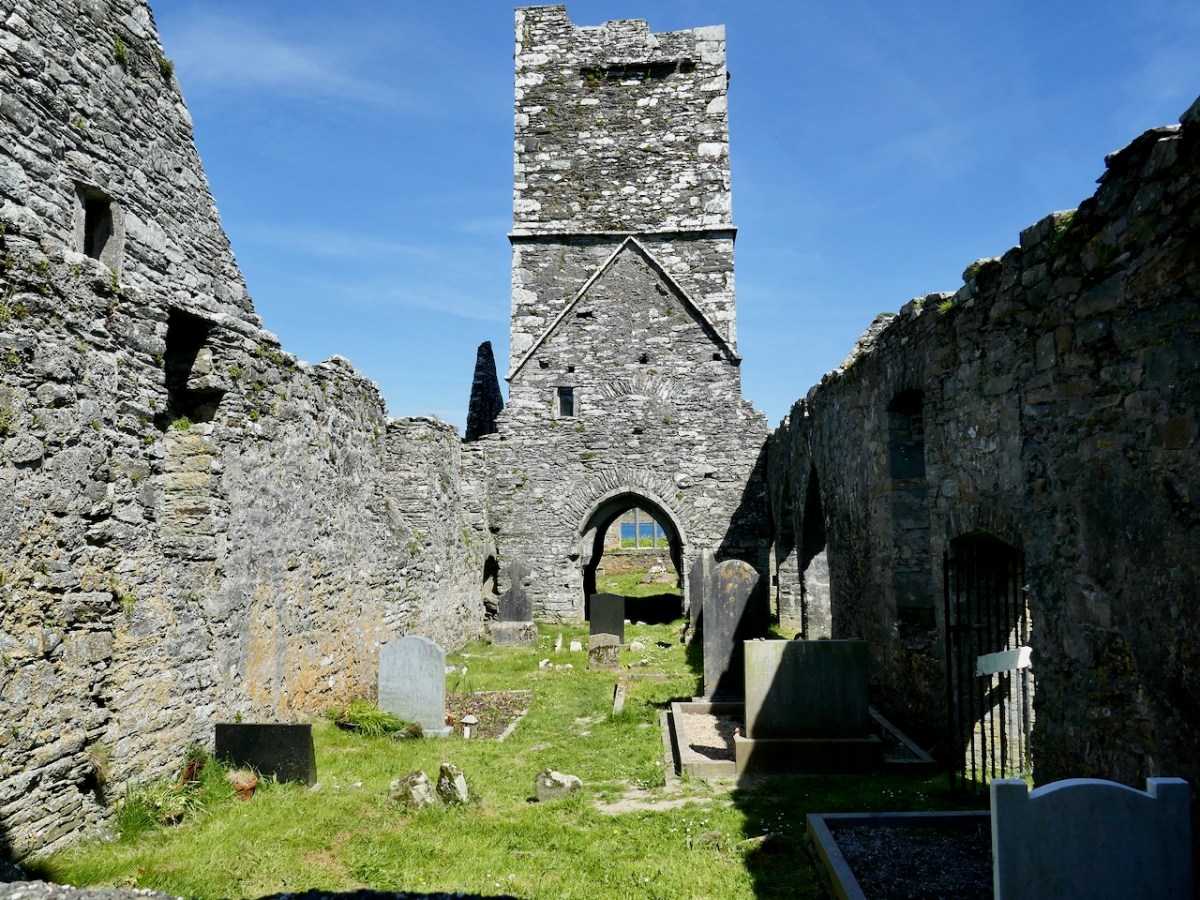
The tower or belfry, situated between the nave and the chancel, is a familiar feature of Franciscan Friaries – we see the same thing (although on a larger scale) in Timoleague.

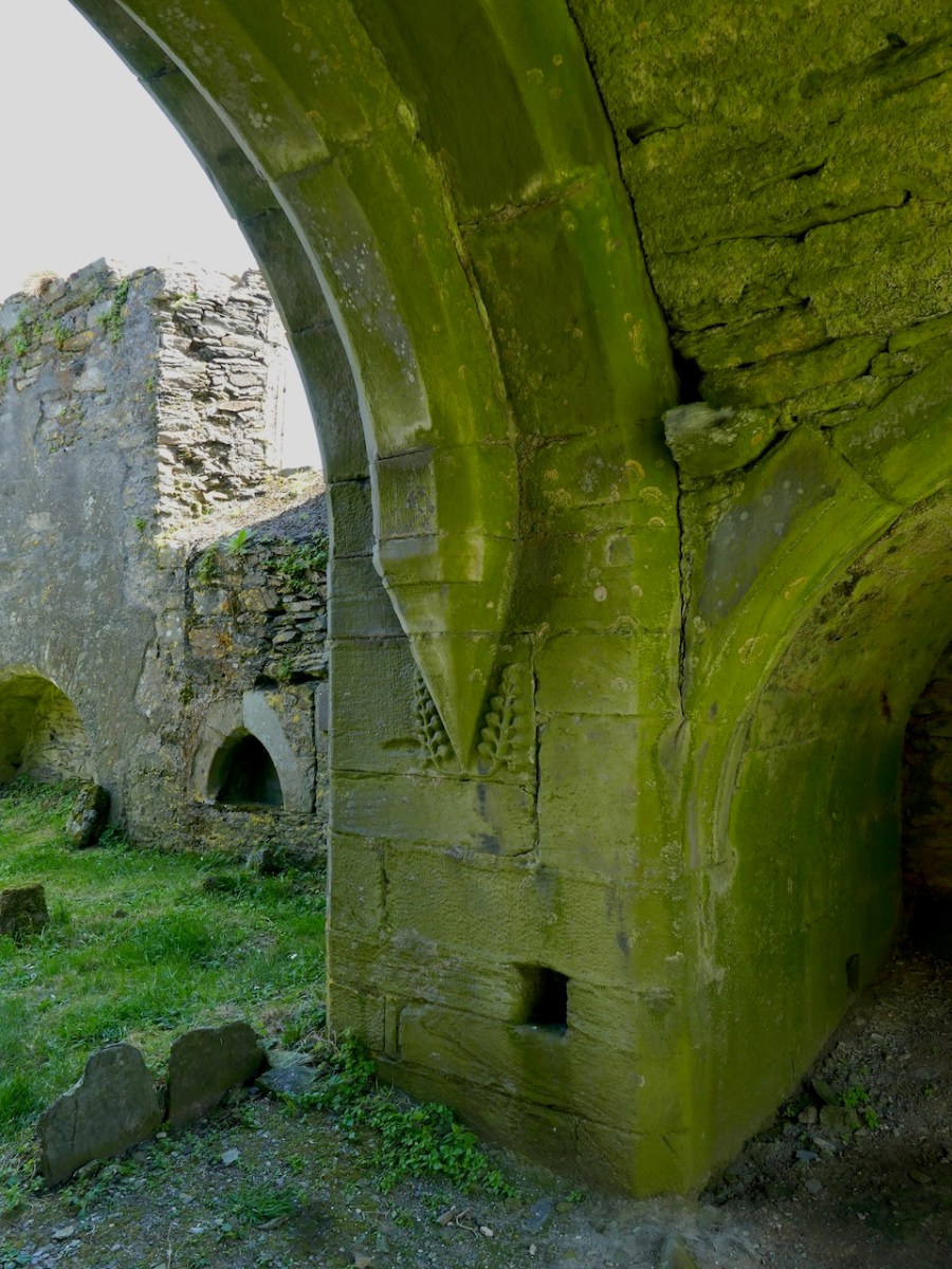
The base of this Sherkin tower has a little decorative carving – a very welcome note of frivolity in what is overall a plain building. Although, of course, we do not know how it was decorated: it may have had frescoes and painted walls and have been quite colourful, although generally the strictly observant friaries were not highly decorated.

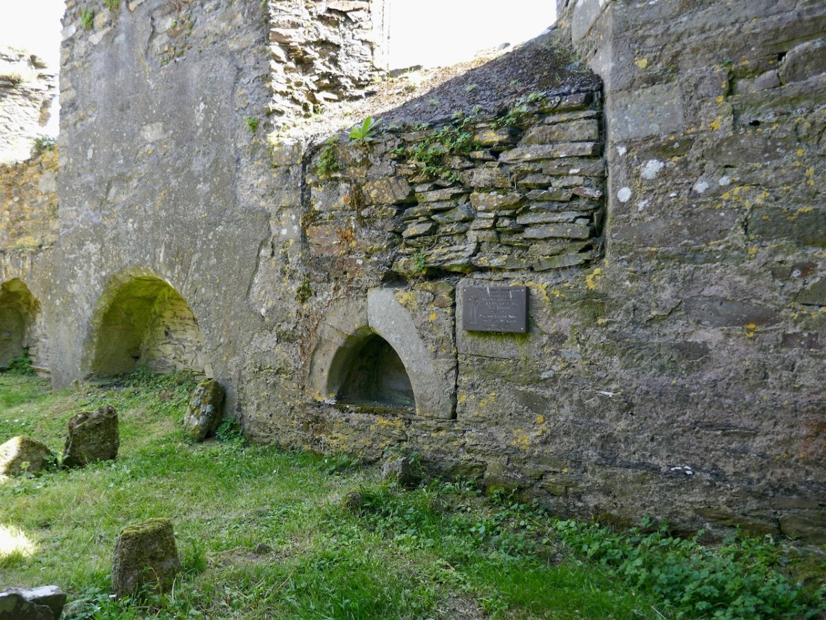
The chancel (the inner sanctum) also has an eastern three-light tracery window, identical to the one at the west end. There are various niches in the walls in the chancel, and I am wondering if one of them might be an Easter Sepulchre. I have just been learning about these in the latest Archaeology Ireland magazine, in a fascinating piece by Christiaan Corlett. You can read more about them here. In essence they were resting places, from Good Friday to Easter Sunday, of the crucifix, the Host and various other sacred elements, all of which would have been contained in a carved box, which was then deposited in the niche. This niche certainly fits the bill, except that it is on the south wall, rather than the more normal north wall.

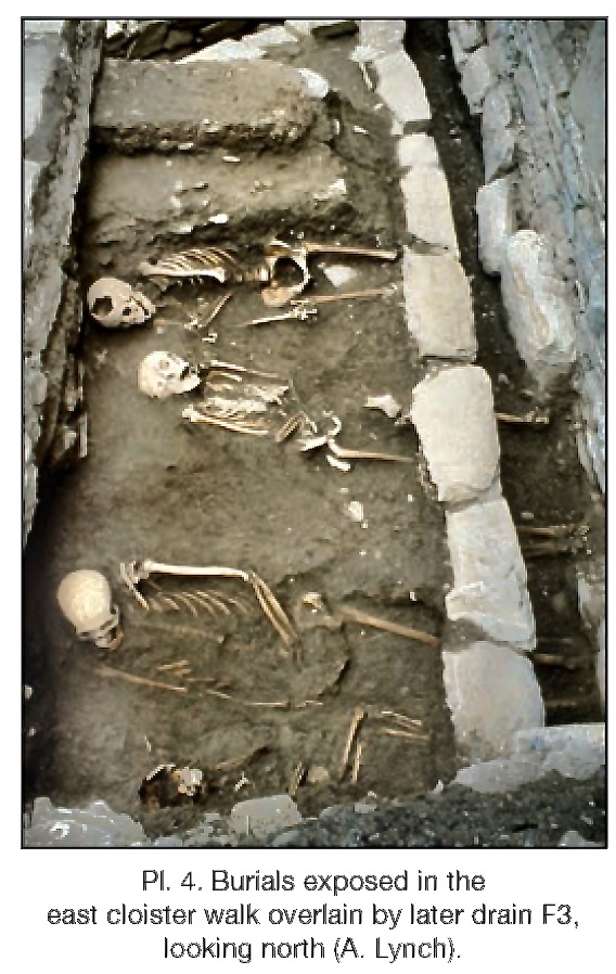
The cloister was filled with rubble when Ann Lynch started her excavations. Nothing of it was to be seen, but as you can see the excavation revealed a small but perfectly formed feature.

And it seems that this is where the monks were buried! As the friars were pacing the cloister walk, intoning their office, they were walking on ground above the bones of their brethren who had died before them. Twenty four of them were found, aligned with their heads to the west and their feet to the east. There were no grave goods: they were buried as simply as they had lived.

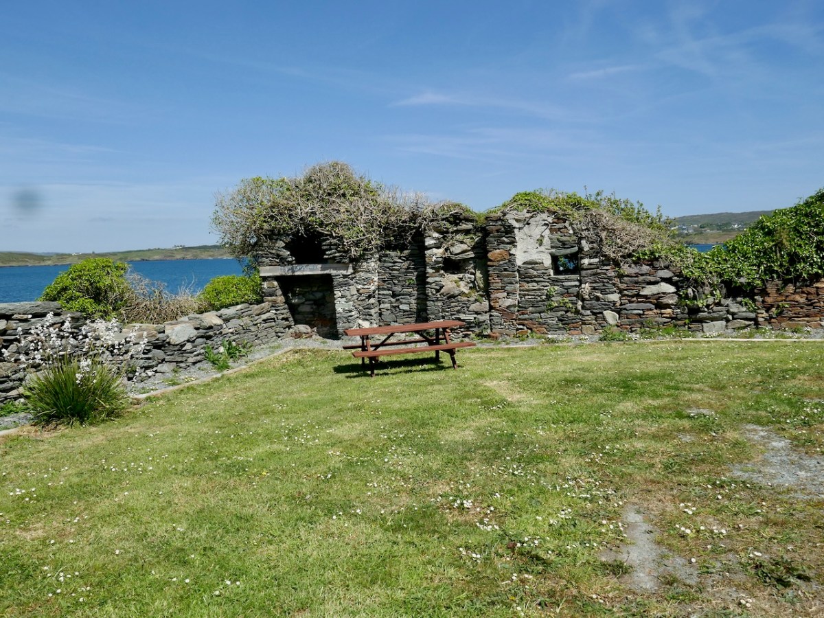
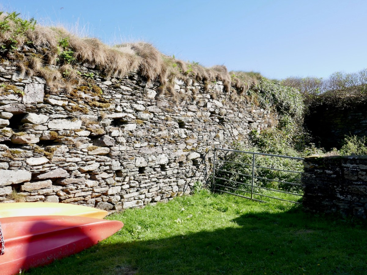
Later, in the 17th and eighteenth centuries, the west end of the friary was used as a fish palace – a place for curing fish and packing them into barrels. The holes in the walls in the image below would have held press-beams. See Robert’s post Fish Palaces and How They Worked, for more on this. Somehow that seems like an ignominious end for a place built as a focus of worship. 

Today, the first thing you see as you step off the ferry is the friary, peaceful and beautiful in its island setting. It has seen its fair share of turbulence, of industry and of neglect. Now it reminds us that life goes on despite all that, but it never stays the same.

Dún na Long Castle, Sherkin Island

Last week I left you at the threshold of the Castle and Friary on Sherkin, promising to come back to them this week. As I read up about them, though, I realise that each deserves a post of its own, so we are going to look at the Castle first.

What we see now is a pale shadow of what the castle looked like in the 15th century. The Friary was built in 1460 and the castle, or tower house, around the same time, maybe a few years later.

The builder of both was Florence O’Driscoll, chief of the wealthy and warlike O’Driscoll clan, whose headquarters were in Baltimore. It was one of a series of O’Driscoll Castles, which also included Oldcourt, Rincolisky, Lough Hyne and Ardagh, as well as Dún an Óir on Cape Clear, Dún na nGall on Ringarory Island. If you have not already done so, take a look at my posts on Dún an Óir, the Fort of Gold, on Cape Clear Island – it will give you some background into the operations of the O’Driscolls and their network of Castles. And this page has a list of all my castle posts and browsing them will explain all the terminologies, such as bawn, or raised entry

Like the O’Mahonys to the west of them, the O’Driscolls derived their income from control of the waters of the eastern side of Roaringwater bay – and specifically control of the fisheries. And that income was considerable: enough to build all those castles, to mount a fleet of ships, to import the finest wines from France and Spain, and enough to endow a friary where Franciscans could pray for the souls of Florence and his descendants so they could be assured of safe passage to Heaven.

Dún na Long (Fort of the Ships) was strategically sited indeed. It had a good view across to Baltimore but more importantly of the entrance to the inner waters – anything that sailed between Sherkin and the mainland was immediately spotted. It was also very close to the Friary, and could defend it if necessary – although that didn’t quite go according to plan, as can be seen from the top photo, a picture of the Battle of the Wine Barrels that took place in 1537 between the O’Driscolls and a force from Waterford, come to take their revenge on the O’Driscolls for their constant raiding of the cargo ships.

Let’s take a closer look at that drawing to see how the artist represents what Dún na Long looked like originally. Due to the shape of the promontory it occupies a long and narrow space, rather than the square or rectangular area we have come to expect, of a tower house surrounded by a Bawn wall (see Illustrating the Tower House). So the bawn wall is there, but elongated to run the length of the promontory. The tower house itself occupies a central position and there is one corner tower on the landward end. Note that the artist shows a huge cannon on the seaward end of the castle. This would have been unusual for an Irish castle, but there is some evidence for it. In the 1895 Journal of the Cork Historical and Archaeological Society, a  Mr H T Fleming notes this:

Wandering around the ruins, it is possible to see the remains of what was once there. The central tower now stands to only two stories. There is an entrance on the ground level, but this is an enlargement of what was originally a window ope. The actual raised entry was in the west wall – you can see it in the photograph below, although it has been much altered. It probably looked like the ground floor and raised entry configuration at Dunmanus Castle.

There is a pronounced base batter, Samuels, in his Tower Houses of West Cork, provides a sketch plan which shows how impressively thick the walls are. 

When he was doing his field work, in the 90s, there was still a roof on the pig shed built onto the west wall and he provides this photograph of how the central tower looked at that time.

The small corner tower can be clearly seen in the photo below as Amanda is wandering down to the castle. 

That tower occupies the corner position on the bawn where the wall that runs along the landward side meets the wall that runs along the sea, closest to the Friary.

In the sketch, you can see the Waterford force has made its way onto the land and is firing at the castle from that side. What is left of this wall has been extended using modern concrete block.

After the battle of Kinsale in 1601, the current clan chief, another Finghín, handed over the castle to the Spaniards, who in turn surrendered it to the English under Captain Harvey. Since that time it has led an anonymous and ignominious existence as a cattle or pig shed.

Nowadays, the site is much tidier than when I have visited in the past. A picnic table provides a pleasant spot to look out over the sea and think about what life was like in this castle in the 15th and 16th centuries. 

Exploring Sherkin

On  a gorgeous day in May, Amanda and I set off to have a day for ourselves on Sherkin Island. No reason, just because it’s there and it’s wild and beautiful and historic.

We caught the 10:30 ferry from Baltimore. It’s a short ride, but along the way you pass the Beacon and get a great view of the Sherkin lighthouse.

We decided to take a Horseshoe Trail – I have provided a map showing our outbound walk in red and our return walk in Blue. It was all easy walking, no steep hills, and since the weather had been so clement in May we didn’t need boots (although Amanda is seldom parted from her wellies).

The Horseshoe Trail is well marked, but narrow, and fringed by wildflowers. I had trouble identifying this one – is it Charlock? Or some kind of Mustard? 

The trail leads down to vistas over Horseshoe Harbour on the south side of the island – a secluded and beautiful cove with Thrift covering the foreshore and Bluebells and Stitchwort in abundance everywhere.

I was fascinated by this little house, standing sentinel over the harbour. What a situation – and it obviously has a history. Above the door is the Papal insignia along with Anno 1932 Congressus

This, of course, is a reference to the Eucharistic Congress, held in Dublin in 1932. Here’s a wonderful account of that time by West Cork Historian, Kieran Doyle

It was the biggest thing to happen in the new state. My parents used to talk about it. Dad was in the Phoenix Park (along with a quarter of Ireland’s population) to hear John McCormack singing Panis Angelicus. Perhaps it was that experience that persuaded him to study for the priesthood. Fortunately for this blog, he discovered his error after a year, and my mother a few years later. But take a listen to what my father heard in 1932.

My mother, by the way, was found of quoting Brendan Behan who said that during the Eucharistic Congress, “Grafton Street was lousy with Bishops”.

But I digress! Let’s get back to Sherkin – although if anyone knows more about why this attractive cottage sports a 1932 Eucharistic Congress sign, do leave a comment.

Our next stop was St Mona’s Holy Well. This is a discrete little well tucked into the hillside of a fern-covered valley. Although Amanda had to battle her way to this well when she first visited, this time we discovered that a recent pilgrim had cleaned up the well and provided very welcome signage. Amanda’s blog provides lots of detail and a link to more information about St Mona, patron saint of the island, who has given her name to the townland of Kilmoon. 

We enjoyed a coffee (I had packed a flask, fearful of a caffeine withdrawal) overlooking Horseshoe Harbour (photo by Amanda) before setting off back to join the main road through the island. My top photo shows the terrain leading to and from the well – we had the real sense of being in a hidden valley.

A detour brought us to a piece of archaeology – a cupmarked stone. Robert and I visited this several years ago and he wrote about it here, so you can take a look at the stone with its 14 cupmarks. I am not giving the location of this as it is on private land

We stopped for a sit-down along the way – the little cafe wasn’t open, but a sleepy cat presided over our rest stop and the Free Palestine sign provided the backdrop.  

On we went then, to Cow Strand where a lovely surprise awaited – good coffee and snacks and a teepee to sit under – it was pretty hot by now (photo by Amanda).

From there we walked to the magnificent Silver Strand, with a view to Cape Clear. 

Sherkin Island is home to the medieval castle, Dún na Long (Fort of the Ships) and a magnificent ruined Friary. A wander around these two monuments was our final destination and to my enormous surprise, as it had never happened before, we were able to go inside the friary. The next blog will take up the story from there. 

Fort of Gold 2: The Castle

This post will be about the castle itself, as a follow-up to Part 1 about the promontory and historical background. I received some very interesting comments on the name, Dún an Óir, which I interpret as Fort of Gold, and I will write more about that at the end of this post. If you are not familiar with castle architecture, before you start, you might want to browse my castles page and pay attention to how they were built and what the castles of Ivaha generally looked like. Unless otherwise identified, all the photographs in this post were kindly sent to me by Tash, one of our readers. In this one, taken from the sea, the impregnable siting of the castle can be appreciated.

The castle was surrounded by a bawn wall, clearly visible still. Three floors (ground, first and second) were surmounted by a ‘partial vault’, above which was the principle chamber or solar – the private domain of the castle owner and his family but also where visitors were entertained.  Above that was a mezzanine floor and above that again was a wall walk, accessed via a spiral staircase from the main chamber. 

In her paper on this castle*, Sarah Kerr points out that it is, in fact, unlike the other O’Driscoll Castles of Dún na Séad and Dún na Long, and indeed other West Cork Castles, in that it only had one entry, at the ground-floor level. It is possible, she says, that the tower was so well defended naturally by its position, that a raised entry (an additional line of defence) was unnecessary. She also points out that a raised entry functioned as a status symbol, since it was the entry used by the chief to access the private rather than the public spaces within the tower. Perhaps Dún an Óir was therefore a lower-status castle, occupied by a garrison rather than by a chieftain. She provides this plan

Another unusual feature is the small projecting tower that contained the garderobes. You can see that projecting addition in the plan, above, and in the photograph, below. The entry led up, via a mural staircase to a door giving admittance to the first floor, and carrying on to entries at the second and third floor levels. From there, another stairs led up to the wall walk.

Flat slabs were used to dress the outside of the walls, the same construction method as at Dunlough, although not as finely built. 

Instead of a complete vault, such as we see at Dunmanus or Rincolisky, there is a ‘partial vault’, described by Samuel:

Two free arches resembling ‘slices’ of a barrel vault were built. The gaps between the arches and the walls created were lintelled over with large overlapping slabs. This ‘economy’ vaulting was much lighter than a complete vault. 

The Tower Houses of West Cork by Mark Samuel

In fact, this type of internal vaulting is not that unusual in West Cork – we saw it at Dunlough and in the small tower at Dunworley. At Dunlough, we can still see many of the large slabs of slate that once bridged the gaps between the arches of the partial vaulting, while at Dunworley the roof is still intact. In Tash’s photograph below you can see the double arches and the full extent of the three floors below them, as well as the chamber above which would have had a pitched wooden roof..

The top room, or chamber, was very high with a pitched roof supported at each end with an archway. The archway also allowed the top of the wall to be kept clear to form a wall walk. A conjectural reconstruction drawing at Ballinacarriga conveys the idea, although Dún an Óir only had one arch, not two.

The battlements have disappeared – they were likely Irish crenellations consisting of stepped merlins and crenels (see here) – but the wall walk can still be discerned. As you can see below, the steps can still be climbed by those brave enough.

Quite a bit of the bawn wall survives, although of course it would have been much higher (possibly as described here). If the sheer cliffs were not enough to deter any thought of attack, the walls would have provided an additional barrier. Unfortunately, they were not able to withstand cannon fire, let alone the passage of hundreds of years. Sarah Kerr has an interesting take on this wall:

Bawns are often considered an additional defensive feature, or at least deterrent. Dún an Óir’s in this regard is somewhat excessive as anyone who could scale the rocky façade of the promontory would likely not be deterred by additional few metres of wall. The bawn, however, would have provided the inhabitants a layer of safety against accidental falls and protection from some of the inclement weather, such as high winds and storm waves from which Roaringwater Bay gets its name. These humdrum practicalities of the medieval lived experience have often been overlooked in castleology or castle-adjacent buildings archaeology, however, it is this very granularity which deepens our understanding of how these buildings worked.


Networked Control: Tower Houses in Ireland by Sarah Kerr

The bawn, in Samuel’s estimation, (that’s his plan above) was big enough to accommodate quite a large herd of cattle. An interesting feature is that of an outside kitchen with an oven, reminding me of what was uncovered at Rincolisky, another O’Driscoll castle, in recent excavations. In the plan above the oven is the circular feature at the north corner of the tower. Other buildings stood inside the bawn, although their purpose is not clear. There may have been a gatehouse, and the ‘possible wall embrasure’ in Kerr’s plan is viewed by Samuel as a corner turret. Samuel lays out what he can interpret of the various walls that surround the castle:

The continuous and well-preserved north wall of the bawn terminates to the west with a return that runs a short distance north before being broken away. This is the inner face, a turret with gunloops which defended the bawn. The curved outer wall enfiladed the mainland with three widely splayed gunloops.

The interpretation of the ruins east of the tower house is more difficult. Erosion has removed the eastermost part of the defences. Two separate walls on the east side of the tower diverge from its orientation; running approximately due east they seem to have formed the north and south walls of a smaller enclosure containing another building. At the west end, the north wall meets a wall (the junction is destroyed) with a gate which abuts the north face of the tower. The robbed jambs of a large gate survive on the east face of the wall and indicates that the gate swung inwards to the west where another enclosure presumably existed. A deep drawbeam is visible in the south jamb. This gate now leads almost directly into a deep ravine. A fair-weather landing stage may have once existed on this side of the island but it would have rarely have been safe to use.


The Tower Houses of West Cork by Mark Samuel

Sarah Kerr positions Dún an Óir in a network of O’Driscoll castles that together worked to control the resources of Roaringwater Bay, to levy fishery dues, monitor trade, and defend territory when necessary. Within this network, the highest status tower, and probably centre of administration was Dún na Séad (Baltimore). The highly visible nature of all these castles, some on promontories and all visible from the sea, were ‘manifestations of authority, wealth and status.’ She posits that: 

Due to Dún an Óir’s lack of a slipway, natural harbour or rock-cut steps, it is unlikely that manging the fish produce was a primary role at this dwelling, particularly as Dún na Long and Dún na Séad were more suited to such tasks. Instead Dún an Óir probably managed the victualing and collection of fees from passing ships, indicating that the tower houses worked in unison. It appears that each tower house had a specific role which complemented one another, as such they were unique actors that performed as a network

Networked Control: Tower Houses in Ireland by Sarah Kerr

It’s surprising how much we can tell from the remains of this once prominent symbol of power. It will never be on a tourist trail and I would not advise anyone to try to access it – but as you can see, Tash and his group managed it.

In response to my first post I had several suggestions for alternate titles on Facebook. Ruamann Ua Ríagáin proposed an alternate interpretation as Dún an Ár, or Fort of the Slaughter. There are no indications that there was any tradition of cattle-slaughtering at this site, nor any record of a massacre. However, it remains a possible interpretation. Another reader, Tom Driscoll found another Dún an Óir which was assumed to come from Dún an Ochair, meaning Fort on the Brink/ Cliff Edge. Certainly apt for this location. Finally, note the long comment on Part 1 by OVERSEASGREATGRANNY who is trying to trace similarly named forts and relate them to Irish history – quite fascinating.

When the storms rage over Roaringwater Bay it is natural to wonder how long this castle can last, isolated on its spit of land and open to the full force of nature. But it is also a comfort to know that the castle builders built it so well that it has lasted now since it was built around 1450 and battered in 1601. Here’s to another few hundred years!

Thanks again for the superb photos, Tash!
Sarah Kerr of UCC has kindly shared with me her draft paper, Networked Control: Tower Houses in Ireland. I thank her sincerely for permission to quote from this unpublished paper.

Fort of Gold 1: The Promontory Fort

I have been gifted with a marvellous set of photographs of Dunanore, or Dún an Óir – an O’Driscoll Castle on Cape Clear. The gift came from one of our readers, Tash, and I am very grateful indeed. Regular readers know that I like to use my own photos, and I do have some that I took from the sea (like the one below) but I have none of Dún an Óir from the land, let alone from the castle itself! 

And that’s because, as you can see from the drawing by Jack Roberts at the top of this post, this castle is situated in a very perilous location, on the edge of a cliff, on a small island, essentially, making access a hazardous scramble up from a rocky beach. It was once connected to the rest of Cape Clear by a narrow causeway but this has long collapsed. It was still there in the 1770s when Charles Smith visited. In his The Ancient and Present State of the city of Cork Vol 1, he wrote:

And this brings us to the name – Dún an Óir. It means, of course, Fort of Gold, and some of the old legends about this place talk about the name coming from stories of buried treasure. But in fact, this has been the name of this fort since the first maps of this area were made in the fifteen hundreds and it speaks to the wealth of the O’Driscoll clan who built it. Remember, their other stronghold, now called Baltimore, was Dún na Séad, or Fort of Jewels (on at least one map given as Castle of Perles). On Sherkin, their castle was Dúnalong – or the Fort of the Ships – that’s it as it is now, below.

There are many accounts of their fleets of ships, and the battles they waged against the Waterfordmen in which they came out the worst for wear when Dunalong was attacked. The scene below, from an information sign on Sherkin, shows the Battle of the Wine Barrels, 1537, with both Dunalong and the Friary on Sherkin in flames

Dún means ‘fort’ but seems to be especially applied to promontory forts in the southwest. Before the castle was built, therefore, it is likely that the O’Driscolls fortified the headland, which may date well back to the Early Medieval period (400-1200) or even to the Iron Age (500BC to 400AD, or 500BCE to 400BC for those who prefer the secular version). The Illustration below is taken with permission from Dún an Óir Castle: an uncertain future, by Dr Sarah Kerr, and shows the present state of the castle, marooned on what was once a promontory connected to the Island.

Our Promontory Fort man is Thomas Westropp (see here and here), and he wrote about Dún an Óir in his 1914-16 paper for the Royal Irish Academy, Fortified Headlands and Castles in Western County Cork. Part I. From Cape Clear to Dunmanus Bay. He visited the site, but like many a good explorer before and after him, did not venture out onto the promontory, but satisfied himself with what he could see from the high ground above it. That included the promontory and ruined castle, the rather ominously named Tonelunga (The sea-bed of the Ships), the end of the promontory called Caenroan (quay of the Seals), the inlet between the promontory and the cliffs, Coosadoona (the Little Harbour of the Fort) and the high cliffs behind the fort, Foilacuslaun (Cliffs of the Castle). All of these are marked on the 19th century twenty-five inch map.

Westropp writes about Dún an Óir as one of three Promontory forts on Cape Clear Island, although in fact there are more than that, as identified by the National Monuments Record – each yellow dot below is one.

Here’s one of them (below), Lios Ó Móine (the Fort of the Meadow – lios is usually used to designate an earthen ring fort): the description and then the photo are by National Monuments Service (NMS). In the photo you can see the narrow neck of land leading out to the promontory. This is likely what the spit leading out to Dún an Óir may have looked like.

Description: In rough pasture, at the foot of a steep N-facing slope on Stuckaunfoilnabena, a headland on the NW coast of Clear Island. A narrow eroding neck of land (Wth 3m; L 15m) leads to the roughly anvil-shaped headland. Across this neck of land are the remains of three earthen banks and the shallow remains of three fosses. Further examination of the remains was not possible for safety reasons.

Curiously, the NMS does NOT identify Dún an Óir as a promontory fort – here is what it says: 

Description: The location of the tower house ‘Doonanore Castle’ (CO153-015002-) on a promontory, on the NW shore of Clear Island, suggested that it may have been built on the site of a promontory fort. However, there are no visible surface traces of an earlier defences across the promontory. The promontory is now isolated at high tide but was connected to mainland by causeway until 1831.

However, it has this to say about the earthwork identified on the high ground: 

In pasture, on a steep N-facing slope to the E of the tower house known as Doonanore Castle . . . An earthen bank . . .extends upslope in a S to SW direction from a modern E-W field boundary wall on the cliff-top at N and ends at a large outcropping rock on the edge of another cliff. This bank appears to have formed part of the defences on the land approach to the castle from the E. The bank has three contiguous linear stretches [and] there is an entrance near the N end. There is a possible hut site near the centre of the enclosed area. The short promontory on which Doonanore Castle stands is a possible coastal promontory fort.

So, as you can see, although the NMS declines to label it a promontory fort because there are no longer any signs of banks or walls, it does concede that it is possible. It also extends the defences of that fort to the higher ground above it.

Back to Westropp – He quotes:

the poem of O Huidhrin, before 1418, tells how “0 hEidersceoil assumed possession of the Harbour of Cler.” It was of some importance to the foreign traders in wine and spices, and so figures in all the early portolan maps. Angelino Dulcert, in 1339, calls it Cap de Clar ; the subsequent portolans, Cauo de Clara, 1375 and 1426 ; Clarros, 1436 ; C. d’Clara or Claro, 1450 and 1552, and, to give no more, Cauo de Chlaram, in 1490. The 0 Driscolls’ Castle probably dates between 1450 and the last date. It was probably on an earlier headland fort, as it is called Dunanore. In 1602 it surrendered without resistance to the English, who burned it.

Westropp goes on to say

Dr. O’Donovan, in his ” Sketches of Carbery,” gives a few notes on the later history. He says there was a garrison at the Castle in Queen Anne’s time, and mentions the huge iron ring-bolt, set in the rock, to which the O Driscolls formerly moored their galleys in the creek. The last is improbable, even to impossibility: no one could moor galleys in the dangerous wave-trap, open to the most stormy and unsheltered points. The islanders regard the ruin as haunted, and tell of the singing of ships’ crews in its vaults. One “Croohoor” (Conor) O’Careavaun (Heremon’s grandson) lived as a hermit there in the eighteenth century. Another legend tells how, in 1798, the inhabitants painted the Farbreag Rocks and pillars so as to resemble soldiers in uniform to keep away the French ! If any truth underlies this, it is probably based on the idle act of some revenue or other officers, in the endless leisure of their island station.

In the map above, of the southwest end of the Island, you can just make out the name Firbreaga, almost covered by the O of OSI. Fir Bréaga means The Lying Men, an apt translation given Westropp’s story. No doubt the name is older than 1798, and may refer to the cliffs at that end seeming to be less dangerous from the sea than they actually were. Note also the two yellow dots for two more promontory forts- Doonthomas (Thomas’s Fort) and Coosfoilaskehaun (the Small Harbour of the Knife-Edge Cliff).

Westropp’s description of the promontory upon which Dun an Óir sits is poetic:

The path runs up a very slight ledge, flaking away and high above the creek, along the face of a cliff of polished silvery slate. The low neck joined it to the mainland, and the nearly perpendicular strata make the dock-like creek of Coosadoona, fort-cove, to the south Beside this cove, opposite to the castle, an enormous precipice rises high above the tower top. In the other direction is a noble view across the wide, porpoise-haunted bay, and its low islands to the blue, many-channelled Mount Gabriel, and on to Mizen Head. 

In fact, very little is known about the history of Dún an Óir before the Battle of Kinsale in 1601. We can deduce from its strategic location that the O’Driscolls used it to keep an eye on every ship that sailed in and out of Roaringwater Bay, to exact fishing dues before the rival O’Mahonys could get to the incoming vessels, to curb the power of those O’Mahonys, and to establish their dominance over the land of Cape Clear Island. (See this post for more on the map above.) Because the castle would have been rendered, probably in some shade of white or near-white, it would have been visible from all around Roaringwater Bay, and have represented a potent statement of supremacy.

After the Battle of Kinsale the Castle was seized by Captain Harvey, as described in Pacata Hibernia:

‘While these things were on doing, Captain Roger Harvy sent a party of men to Cape Clear, the castle whereof being guarded by Captain Tirrell’s men, which they could not gain, but they pillaged the island and brought thence three boats; and the second day following the rebels not liking the neighbourhood of the English, quitted the castle, wherein Captain Harvy placed a guard. At this time Sir Finnin O’Driscoll came to Captain Harvy and submitted himself.’

This illustration, from Pacata Hibernia, is of the siege of Dunboy Castle, the stronghold of O’Sullivan Beare, on Beara Peninsula. The destruction of Dún an Óir is described by James Burke in his article Cape Clear Island in the Journal of the Cork Historical and Archaeological Society Journal of 1908. Rather than Harvey simply taking over the castle, Burke relates the following:

Its central arch and the steps leading to its upper portion remain; but the huge pieces of its eastern wall now lying about show how severely it has suffered from the havoc of war. This wholesale destruction occurred when Dunanore Castle, together with the island, was captured on the 22nd of March, 1601, by Captain Roger Harvey, following on the defeat of the Spaniards at Kinsale. By means of the artillery he planted on the high ground adjoining it, he battered down the eastern wall and compelled the garrison to surrender, for which and other services (as Dr Donovan writes in his “Sketches of Carbery”) he was granted at the time a commission by Lord Deputy Mountjoy as Governor of Carbery.

It is far more likely that the ruined state of the castle is a result of the natural passage of time than the ‘havoc of war.’ For one thing, it would have been a monumental task to deploy artillery overland on Cape Clear. Any cannon fire would have come more naturally from the English warships we know were in use during this period and therefore, the damage would have been to the seaward side of the castle – but this side is actually intact.

A romantic view of the ruins of Dún an Óir above, by W Willes.* Next week we will look at what is left of the castle and what we can tell from that. I’ll be using the marvellous photos from Tash in that post.

*From: Picturesque Ireland : a literary and artistic delineation of the natural scenery, remarkable places, historical antiquities, public buildings, ancient abbeys, towers, castles, and other romantic and attractive features of Ireland, by John Savage, 1885.

A Walk on Sherkin Island

You can’t live in West Cork without constantly being aware of the sea – it’s all around us. And the offshore islands are always in our view as we look across Roaringwater Bay. It’s easy to get to the inhabited ones: there are good ferry services that run year round, although they can be hampered by winter storms. In this picture – above – the Cape Clear Ferry is leaving Baltimore, while the Sherkin Ferry is arriving to collect passengers for that island, including us: on a whim we went across on a wonderful warm September afternoon.

It’s a short sea voyage to Sherkin – all of 15 minutes! But it’s always exciting to be on the water. That’s the lighthouse on Sherkin in the picture above: it was built in 1885 of cast-iron construction and is now fully automated, as are all of Ireland’s lighthouses today.

We did have an aim – to find a piece of Rock Art that may be the earliest physical evidence of human occupation on the island. It’s a cupmarked stone in the townland of Kilmoon, overlooking Kinish Harbour. It was a fair walk to the west, over deserted roads and through fields. After a bit of backtracking we managed to find the stone, well weathered but with its markings still visible. It is situated with panoramic views all the way round, taking in the peaks of Mount Gabriel, Mount Corrin and Mount Kidd on the mainland: surely it must have been placed with those views in mind?

This picture shows the cupmarked stone in its present setting, just inside a private garden (if you go, please make sure you seek permission from the owners of the house!), while the one above shows the panoramic distant view which the stone commands.

Here is the surface of the stone which is heavily blotched with lichen, but it is possible to make out the well defined cupmarks: there are 14 in all. If you want to find out more about cupmarked stones and how they compare with Rock Art in general, we wrote this post a while ago. It sparked off a whole lot of debate (have a look at the comments at the end of that post) – and there is still much to be discovered in a history that may go back 5,000 years.

Our main mission was accomplished, but we couldn’t resist taking in some other historical sites while on the island. Firstly, we had a good look at the Franciscan friary – situated in the townland of Farranacoush – which has a colourful history. Here is a description from the current Irish Franciscans site:

. . . Permission for this foundation was given by Rome to Finighin O’Driscoll in 1449, but it was not until just after 1462 that the Observant friars actually arrived. The friary became the traditional burial place of the O’Driscoll’s. In 1537 the citizens of Waterford burned the building in retaliation for acts of piracy by the O’Driscolls. The great bell of the friary was on display in Waterford as late as 1615. There is no evidence to suggest that the friars were disturbed by the events of the Reformation until the island was garrisoned by the English following the Battle of Kinsale. The friars soon returned and, except at the height of the Cromwellian persecu­tion, were active all during the seventeenth and well into the eighteenth centuries. The last friar, Fr Patrick Hayes, died soon after 1766 . . .

In the picture above – taken from the OPW information board – you can see the attacks of 1537 by ‘the citizens of Waterford’ on both the Friary (in the foreground) and the O’Driscoll stronghold of Dún na Long (beyond). The castle was subsequently partially rebuilt and was garrisoned by a Spanish force in 1601. It was then acquired and restored by the Becher family in 1655 and remained in their ownership until the late nineteenth century. We went to see what remains of the castle today.

Our visit to Sherkin only took an afternoon – albeit a golden one. There’s plenty more to see there – and other islands to be investigated. And an endless exploration of history to be had in the landscapes of West Cork.