
The series continues! In my previous posts on Napoleonic Signal Towers around the Irish coast (the posts are listed at the end of this one) I stated that 81 towers were built between 1803 and 1806, of which 20 were situated in the County of Cork. Today’s example is firmly within the chimerical district of West Cork. I use the word ‘chimerical’ in this sense: “. . . existing only as the product of unchecked imagination . . .” as there is actually geographically no such place as West Cork, even though we write about it all the time – and claim to live within it!

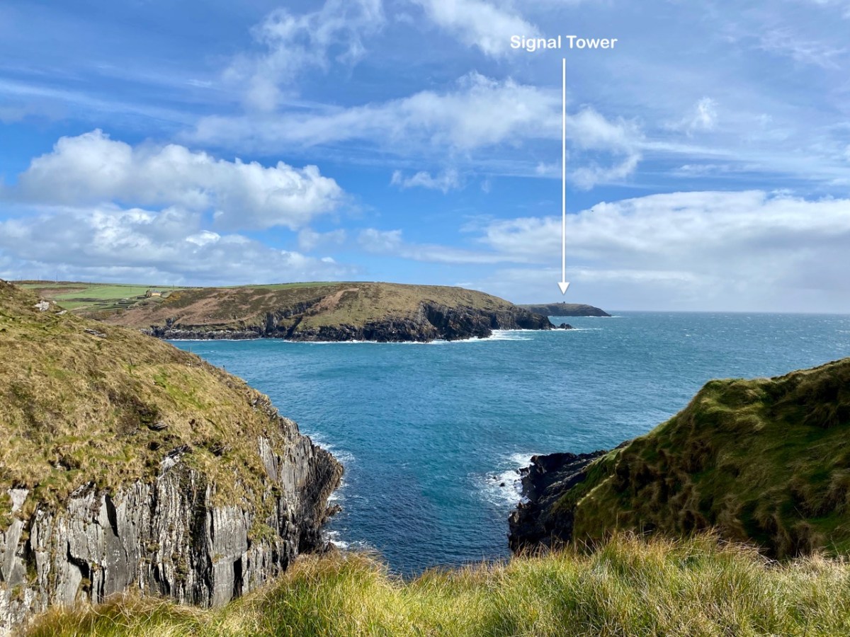
Today’s example has various names: Seven Heads (it’s sited on one of them); Leganagh (that’s the immediate locality) and Ballymacredmond, which is the townland name. It is also called Travarra on some maps and by local people: that is the name of a bay which is over a kilometre to the north-east (and refers to the Barry family who lived in the district). From this tower can be seen another to the west (Dunnycove or Galley Head – which I have written about here), and to the east the tower at The Old Head of Kinsale, here, which is in the present day the best standing example as it has been fully restored and is open to visitors as a historic structure.
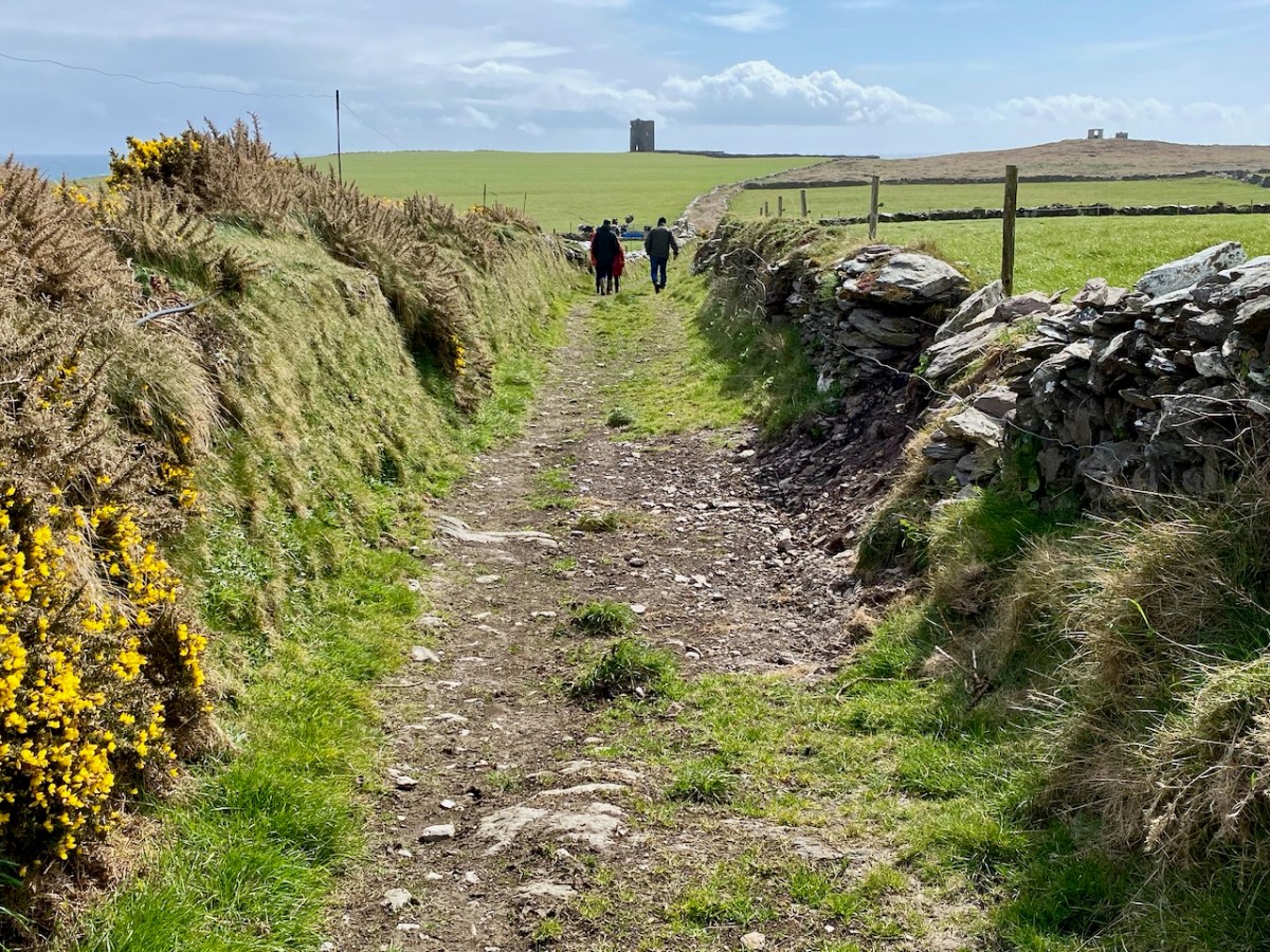
The first two photographs in this post show the Seven Heads Tower which we visited a few days ago as part of a very full expedition which also took in holy wells, promontory forts, and some impressive medieval structures. We had the local help and expertise of guides Diarmuid Kingston and Tim Feen, and were accompanied by our friends Amanda and Peter Clarke, whom you have met frequently in our writings: Amanda runs the Holy Wells of Cork and Kerry blog. The pic above shows our group walking along the clearly defined old roadway which was built to access this signal tower.

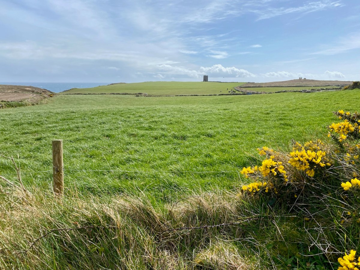
We also had bovine company (above)! This is a constant when you are walking in West Cork. As you can see, our day was mixed, with dark storm clouds and high winds interspersed with good spells of sunshine. The varying light enabled some dramatic photography:


The defined trackway and various well-built stone walls – which I am assuming are contemporary with the tower – show what a significant undertaking this project was in the early years of the nineteenth century. One particular wall to the west of the tower is a noteworthy structure as it is high (between 1.5 and 2.5 metres in places) with some puzzling lintolled openings. The photograph below I have borrowed with thanks from Dominic Creedon as I was unable to get close due to very adverse weather.


You can make out this enigmatic wall on the Google Earth image, above. It is parallel with, and to the west of, the old access road, and forms the western boundary of three rectangular fields. I can find no information on this wall on any history or archaeology sites. I’m tentatively suggesting that it might have been constructed as part of the signal tower works to create a sheltered garden or external storage area: the towers accommodated crews on a rotating basis while in use, and the ‘garden’ – if that is what it was – could have provided a welcome source of fresh produce.

This remote site is also of interest as it has the ruins of two World War 2 Coastal Lookout Posts within a short distance of the Napoleonic-era Signal Tower. I haven’t been able to find out why two were needed here: I can only assume that the first did not prove to give sufficient surveillance. This twentieth century context and link is not unusual, as both lookout posts and signal towers effectively served the same purpose: to keep a watch out for enemy activity, and to alert the appropriate authorities if such activity was spotted. In reality, no such activity was ever reported during either conflict. Written records exist from all the WW2 LOPs (Lookout Posts). Here is an example page from the Seven Heads site, typical of all such records:


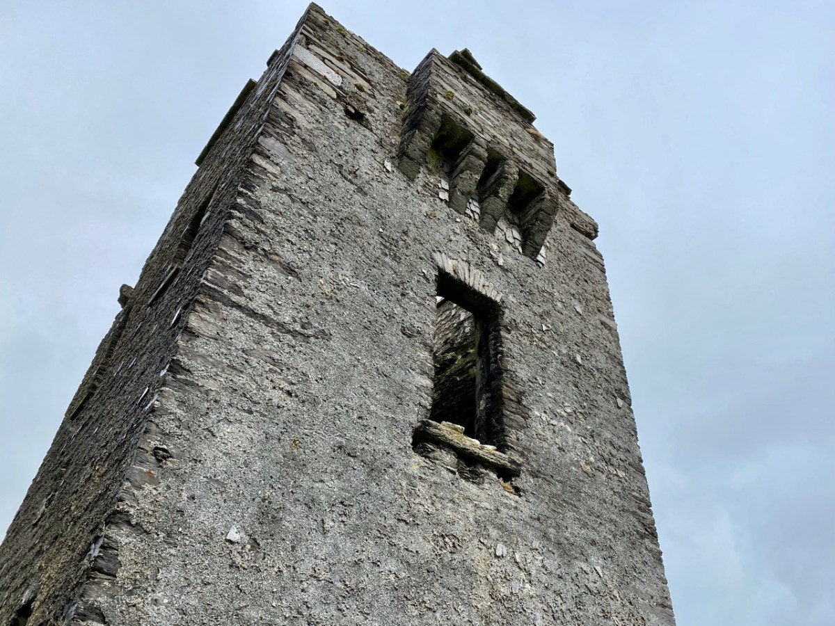
Above are various views of the Signal Tower: it is typical of such structures in general design and layout. Note the machicolation incorporated into the upper parapet: this is an echo of the design of medieval tower houses. The Seven Heads building is an open ruin and is slowly deteriorating. It is sure to crumble away over time. The Seven Heads Walking Trail takes you past the site.

Tailpiece: the pic below is taken from the Dunworley promontory fort, looking towards Seven Heads, and the final pic shows the dramatic sky which enhanced our visit.

The previous posts in this series can be found through these links:
Part 2: Ballyroon Mountain, Co Cork
Part 3: Old Head of Kinsale, Co Cork
Part 4: Robert’s Head, Co Cork
Discover more from Roaringwater Journal
Subscribe to get the latest posts sent to your email.

Oh my, great pics and narrative- also a timely reminder that we haven’t yet managed to get to Galley Head. And ( shame on us) didn’t know that the signal tower at The Old Head was open to visitors. Some done, more to do for sure..
LikeLiked by 2 people
Well, Una, there are over 80 signal towers around the coast of Ireland: visiting them could keep us busy for life!
LikeLiked by 1 person
I always wonder who it was planned and facilitated the positioning of these towers. `How were they paid fr`/ How long did they take to build? They were built by craftsmen, that much is obvious.
Was there some obscure government department that dealt with the deployment, ordering, execution?
LikeLiked by 1 person
Michael, the work was under the supervision of Rear Admiral Hawkins Whitshed RN acting for the Lord Lieutenant (Lord Hardwicke). Building of the towers was commenced in 1804 and mostly completed (81 towers) by 1806. It seems likely that the workforces for each tower were assembled locally. I’ll by writing more on this in a later post.
LikeLike
Those fascinating lintelled openings, I believe we have several examples here in the Blackstairs. My hunch is they were clever accesses for sheep from field to field, thereby avoiding a weak gate opening and the need to maintain same. A few loose boulders would block up the entrance quickly again! I’ll try send you a photo from here, but it would be most interesting to hear more Cork theories. Paddy
LikeLiked by 1 person
Thank you, Paddy. That’s really interesting. What intrigues me is the height of this particular wall – much higher than the field boundaries generally in the area, For shelter, surely? It’s a wild place…
LikeLiked by 1 person
What a day! This was in a such a dramatic and remote position I couldn’t help but wonder what it was like to be posted here and how long a shift was. You have managed to take some wonderful photos considering the weather was quite so challenging!
LikeLiked by 2 people
Good question, Amanda. We are told that there were generally six men posted to each tower on a ‘shift’ – “…with a distinct apartment for the officer…!” I imagine they were probably there for a few weeks at a time.
LikeLiked by 2 people
Greetings Robert, I take a little exception to the Napoleonic descriptor. The era yes, but not the builders thereof. Presumably the British Admiralty, perhaps starting a long tradition of contracting building to Irish enterprise! All the best. PD
All the best Paul Dyson 818 371 9516
>
LikeLiked by 2 people
Thank you Paul. They are always described as ‘Napoleonic era’ and it was because of the threat of an invasion by the French forces who would support the unrest of the general population in Ireland that they were built, After the French revolution, of course, it was feared that a similar uprising might be generated within the British Isles against the ‘ruling classes’…
LikeLiked by 1 person
So interesting and such a beautiful area! Thank you for an amazing story of your trip! Gary from the USA
LikeLike