Night’s Candles are Burnt Out

There’s a wealth of tales to be told about the first decades of independent Ireland. The 1920s and 1930s saw a flourishing of confident projects portraying a nation on the cusp of change, establishing itself in Europe and beyond. One such was the hydro-electric scheme at Ardnacrusha on the River Shannon. Foundations were laid in 1925 and works completed within four years, providing the young country with what was then the world’s largest power station. The intention was to enable everyone in Ireland to avail of the most trendsetting modern commodity: electricity.

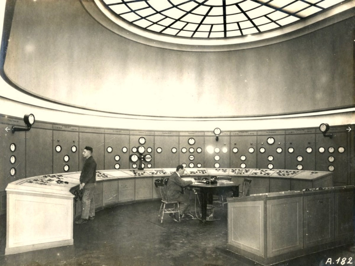
The documentary photo above looks like a scene from a science-fiction film: it’s the control station at Ardnacrushsa, shortly after the completion of the project. This, and many other of the illustrations which I will refer to, are taken from the excellent ESB Archives: I am very grateful to them for the use of these. The building of the huge dam and power station was documented in fine detail – and not just in words and photographs. The notoriously outspoken and visionary artist – Seán Keating – chose to record the accomplishments in his own medium, painting.

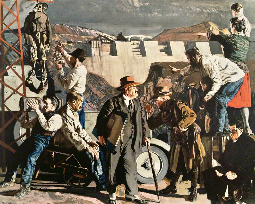
This is one of Keating’s works from the time: Night’s Candles are Burnt Out. (Thanks to Gallery Oldham). It is, perhaps, the finale of his series drawn and painted during the construction of the works – which he undertook on site under his own initiative and without a sponsor. Art historian (and biographer of Keating) Dr Éimear O’Connor suggests:

. . . Keating went down to Ardnacrusha because he knew that the construction project was emerging history. It was all happening around where he was born and raised. The machinery was going to carve up this landscape that he saw as ‘a medieval dungheap’, that was how he described it in later years. And this was a metaphor for him, the whole thing was all about Ireland moving forward into modernity. Night’s Candles features the dam at Ardnacrusha, but also includes a group of figures in the foreground, all of whom represent different aspects of what Keating saw as the Ireland of the day. When he showed it at the Royal Hibernian Academy in Dublin, it was called ‘the problem painting of the year,’ which Keating thought was hilarious. They couldn’t get their heads around this idea of what he was trying to do at all . . .

O’Connor: Seán Keating: Art, Politics and Building the Irish Nation, 2013 (Irish Academic Press)

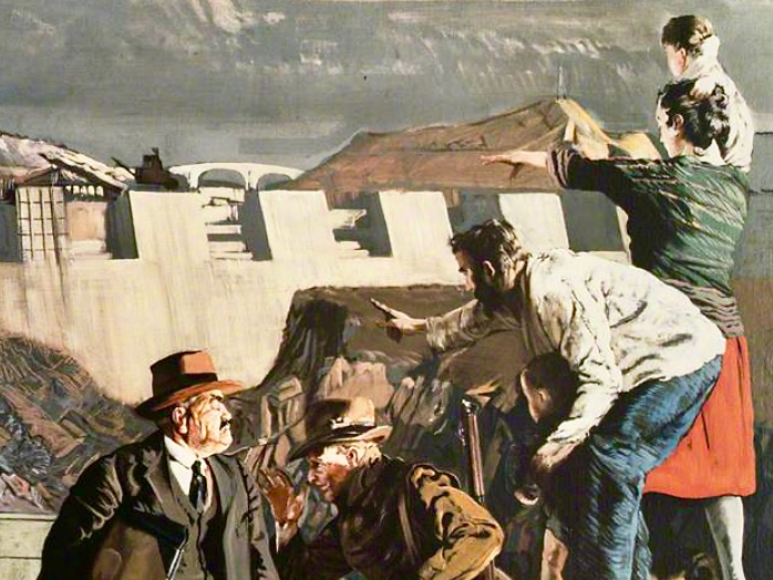
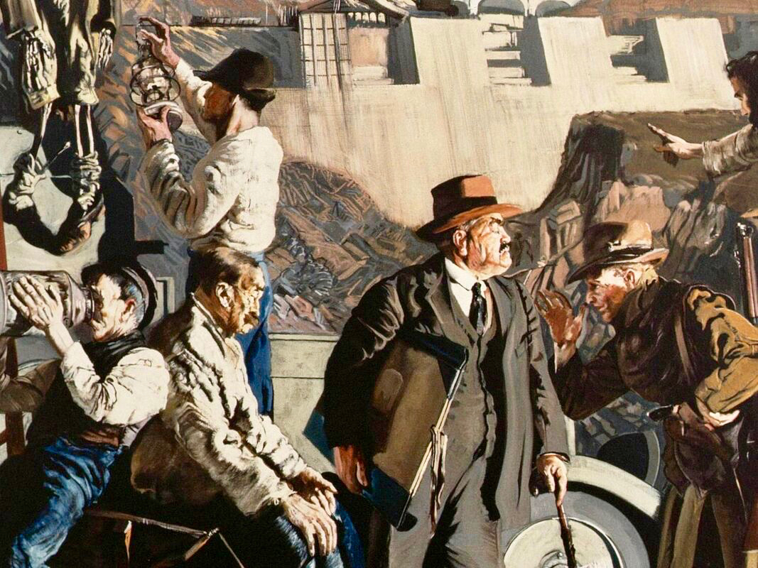
In this detail from the painting we see Keating himself (top right) together with his wife and sons, pointing to the vision of Ireland’s future. On the left of the full painting is Keating again, inspecting a hanging skeleton, perhaps reminiscent of the Famine. Most significantly, perhaps, at the bottom right is a priest reading by the light of the candle. O’Connor is clear about this portrayal:

. . . It tells you an awful lot about Keating and his attitude to the Church at the time. Like many others in the cultural sphere in Ireland, he was disappointed with post-Treaty Ireland, with successive governments and the Church, who were in cahoots, if you know what I mean. He knew well that the whole country was tied up with them, and with that kind of organized religion that was deeply conservative. And Night’s Candles is very much an expression of that disappointment, I think . . .

O’Connor: Seán Keating: Art, Politics and Building the Irish Nation, 2013 (Irish Academic Press)

It’s worth dwelling on this painting a little longer, and viewing Keating’s thought processes, through O’Connor’s eyes:

. . . What Keating was trying to do was reflect upon a country on the brink of change. It was in those years, in the 1920s, that the term ‘gombeen man’ came into being. We all know that it means the kind of businessman or politician who’s making money off the backs of everybody else. And that’s the gombeen man in the middle of the painting. I think it’s quite clear that Keating’s hope was that modernity, as represented by Ardnacrusha, would end all that stage-Ireland paddywhackery that had prevailed for years . . .

O’Connor: Seán Keating: Art, Politics and Building the Irish Nation, 2013 (Irish Academic Press)

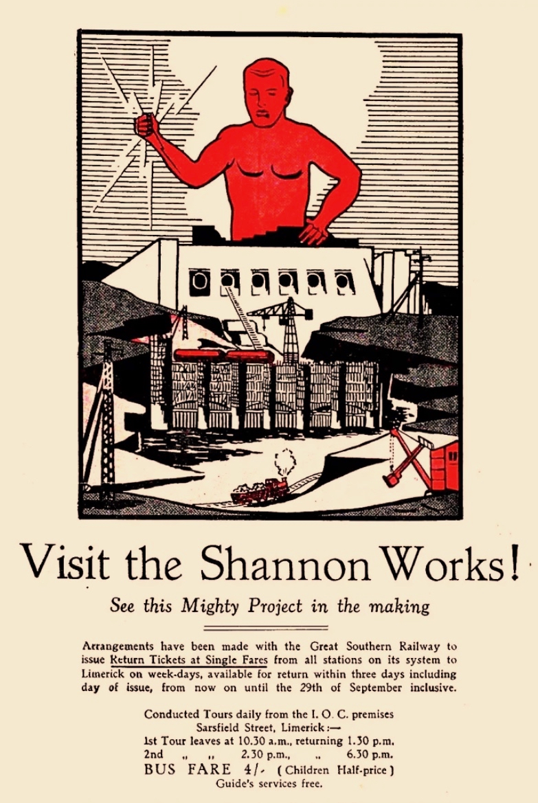
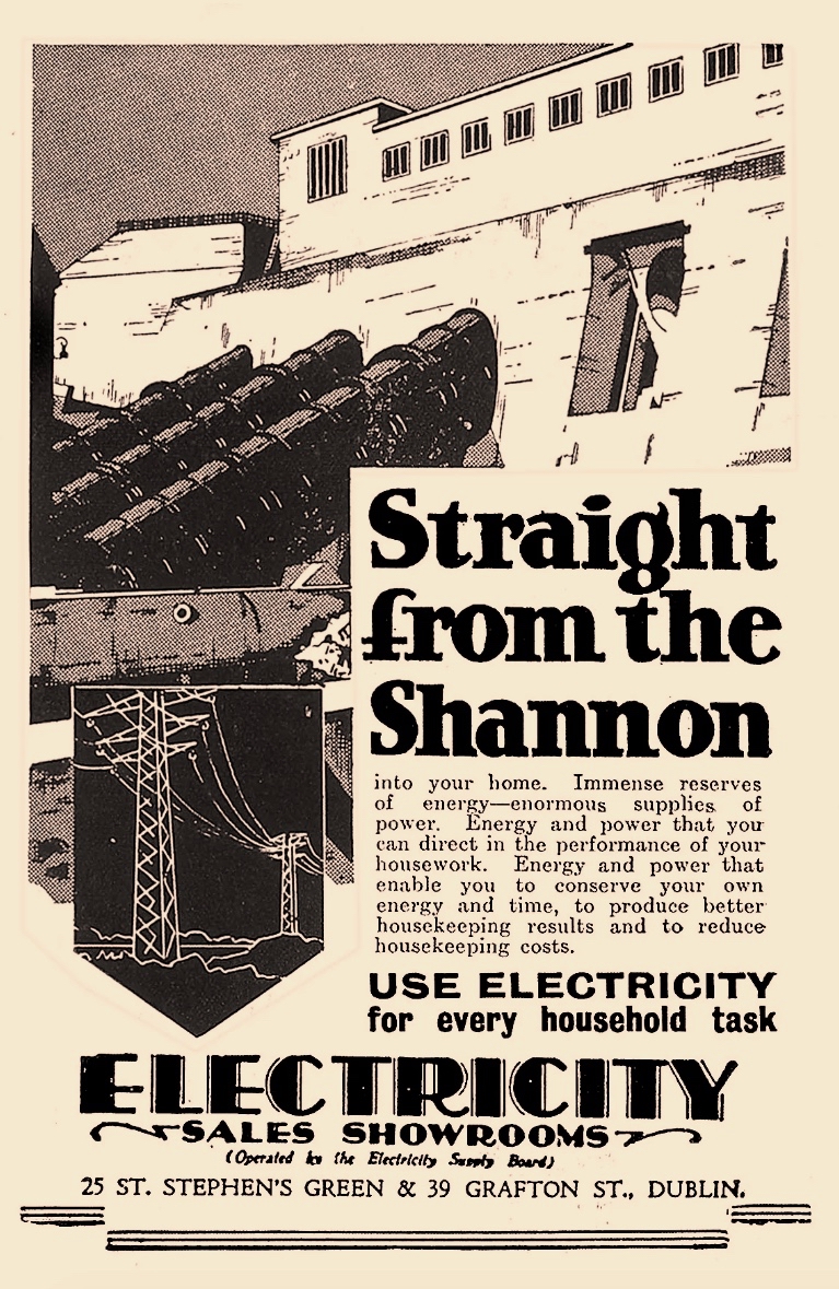
Above – posters from the time of the construction work at Ardnacrusha (ESB Archives). It was certainly the most exciting project in Ireland’s young days, and tourism was encouraged. Hand-in-hand with the major works themselves went a crucial publicity campaign to encourage people to embrace the coming of a readily available electricity supply to homes and businesses. The steps taken to try and ‘get the message across’ was an uphill task. Considerable funds were expended – and a large sales force garnered – to tour the country and persuade the population to buy into the project.

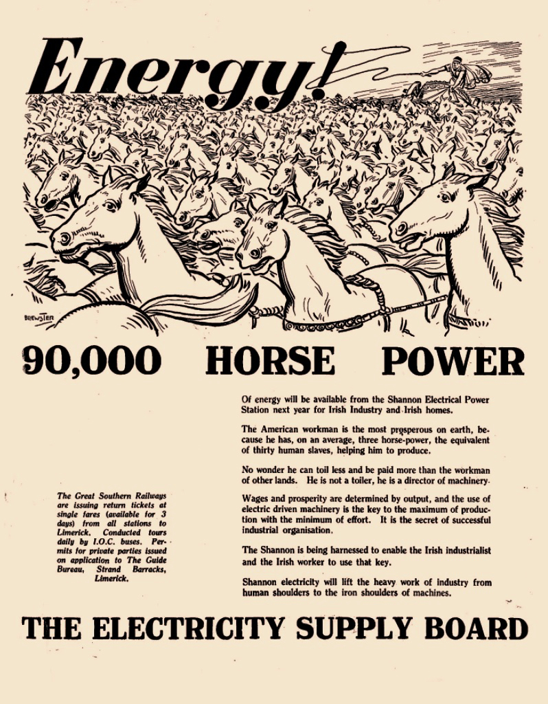
The visuals, humour and underlying psychology of this Ardnacrusha construction-era promotional poster really appeal to me. In case you can’t read the ‘small print’, this is the message that’s being pushed:

. . . 90,000 Horse Power of energy will be available from the Shannon Electrical Power Station next year for Irish Industry and Irish homes . . . The American workman is the most prosperous on earth, because he has, on average, three horse-power, the equivalent of thirty human slaves, helping him to produce. No wonder he can toil less and be paid more than the workman of other lands. He is not a toiler, he is a director of machinery . . .

Post-Famine, America was always seen as the ‘golden land of opportunity’ for Irish emigrants. Now, in 1930, we are being told that Ireland will have the capability to match those fabled fortunes!

. . . Shannon Electricity will lift the heavy work of industry from human shoulders to the iron shoulders of machines . . .

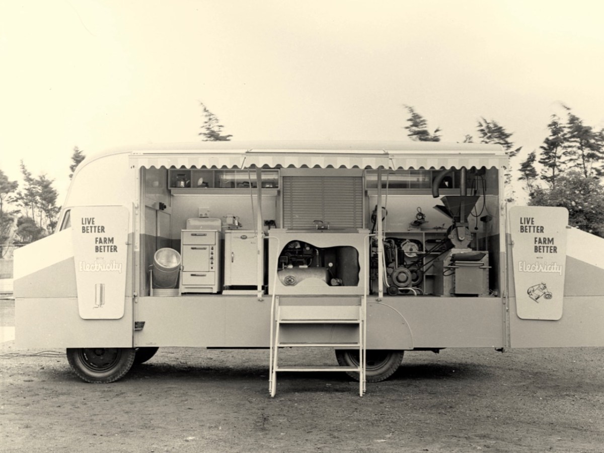
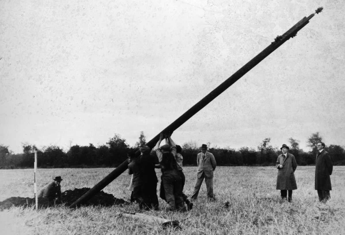
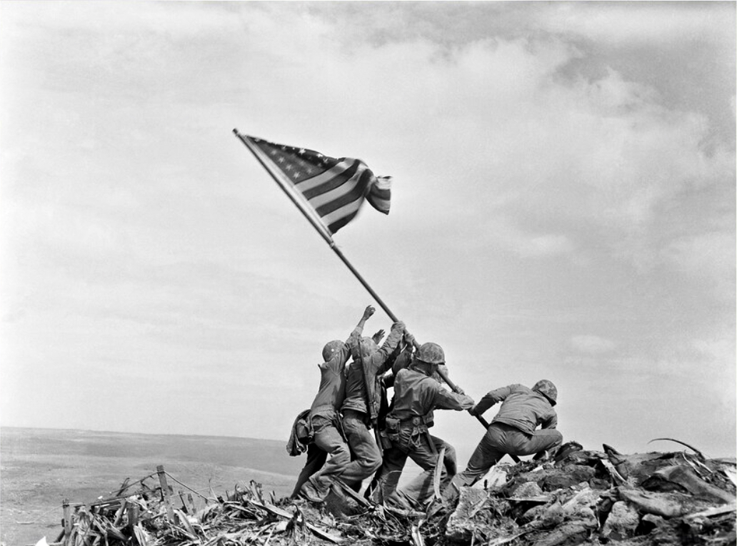
The coming of electricity across Ireland opened up markets for retailers to vend a host of innovative gadgets. This mobile electricity showroom from the 1950s (ESB Archives) covers the gamut of lighting, cooking, refrigerating, water supply to sinks using pumps, milking machines and labour-saving devices for farms. In a future post I want to focus on Rural Electrification, which was a long haul: taking poles and wires out into the extensive hinterland. This was – arguably – the most heroic part of the process of electrification, and we can’t help wondering whether the following somewhat iconic ESB print of the first ‘peg’ being raised at Kilsallaghan, on 5 November 1946 was inspired by the famous Iwo Jima Victory photograph taken by Associated Press photographer Joe Rosenthal on February 23 1945 (lower pic). Both portray a moment of triumph.

Many thanks are due to Michael Barry who referred me to material from the ESB Archives covering our own West Cork areas. Watch out for our commentary on this in a forthcoming post!

The Elusive Lighter (Sweet Ilen – Part 8)

This photo of the West Cork Hotel beside the Ilen River, Skibbereen (courtesy of the NLI Lawrence Collection) captures a moment in time. It was taken in the very early 20th century – probably before 1910. Clearly seen are the hotel itself – opened in 1902 – the old iron road bridge which was superseded in 1964, and the railway bridge behind it carrying the line to Baltimore (which was opened in May 1893). That bridge still exists, of course, although the line closed in 1961. To the right of the photo is the Old Steam Mill, originally constructed as a flour mill by Thomas Marmion in the 1830s. This building stands on Steam Mill Quay.

The Irish name for this town, an Sciobairín, is said to mean a small inlet for docking boats. Steam Mill Quay is the first of five quays which served the town, suggesting a period when the river itself (tidal to just north of the town) was the life blood of the community:

. . . Skibbereen was a settlement served by water. The River Ilen is tidal and in the early 19th century boats of up to 200 tons could navigate to Oldcourt, within two miles of the town centre. From there goods were transferred into ‘lighters’ (unpowered barges) and then brought into the quays where there were warehouses and a Custom House. Now, sadly, Skibbereen’s waterfront is a bit neglected and its active past shipping history is no longer obvious. Five historic quays have been identified along the river: Steam Mill Quay, Long Quay, Levis Quay, Minihane’s Quay and Chapel Quay . . .

Roaringwater Journal

Here is the Custom House – now a private residence on Townshend Street. The first edition of the OS map (above the photo) marks the location. It’s a fine building, clearly of some standing, with its decorative niches and curved fanlight. The existence of this building in the town emphasises the historic significance of importation and trading of commodities, probably primarily by water transport, to Skibbereen when it was operating. I was surprised to find that Hansard – the official record of the actions of the British Parliament – has one entry pertaining to the Skibbereen Custom House. From it we learn that its business was transferred to Bantry in 1890, and that this was a cause of concern to some of the townspeople and local fishermen:

. . . DR KENNY (Cork, S) I beg to ask the Secretary to the Treasury whether he is aware that owing to the transference of the Custom House from Skibbereen to Bantry very great inconvenience and injury are caused to the Baltimore fishing industry; whether, according to existing Customs arrangements in Skibbereen. the Deputy Officer of Customs in that town is unable to give permission for the discharge of cargoes of ice absolutely essential for the preservation of the fish caught by the Baltimore fishermen, and also that it is impossible for him to obtain permission by telegraph from Bantry to do so, and whether, in consequence, steamers for conveying the fish have to wait at Baltimore the arrival from Bantry, 24 miles distant, of the Superintendent of Customs; and whether he will take steps to have abated the inconvenience complained of, by restoring the Custom House to the Skibbereen district?

Hansard record of Commons Sitting 08 May 1890 § 469

There is a further record giving the response by the then Secretary to the Treasury: it lacks sympathy!

. . . Mr. JACKSON (Leeds, N) I am informed that it is not the fact that very great  inconvenience and injury have been caused to the Baltimore fishing industry through the transference of the principal Customs Offices for the Port of Skibbereen from Skibbereen to Bantry. The Board of Customs have ascertained that no delay has been caused by this change in the discharge of any vessels, nor need any delay or inconvenience be occasioned thereby, as the Officer of Customs still stationed at Skibbereen is now empowered to deal with any Customs business, there or at Baltimore, that may require attention, under exactly the same conditions as were in force previous to the change referred to. No occasion has, therefore, arisen for making any alterations in the. present arrangements . . .

Hansard record of Commons Sitting 08 May 1890 § 470

Here’s a distant view of Skibbereen from the west, probably taken in the early 20th century (courtesy of the NLI Lawrence Collection). On the left, the roadway (today’s N71 going from the town towards Ballydehob) has the track of the Schull railway (or – more properly – ‘tramway’) on its verge. The old bridge into town and the West Cork Hotel are visible, as they are in the header picture. What is noticeable is that there is no sign of any navigation of the Ilen River. I have looked carefully through over 200 early photographs of the town and it is the case that none shows any river craft. Hence my title today (and I apologise for taking a long time to get to this) The Elusive Lighters. We have no detailed records of any boats that used the river, and the quays, except that they were shallow-drafted unpowered barges. The term ‘lighters’ usually refers to ‘dumb’ boats (unpowered) used to offload cargoes from ships and transfer these to quays further inland. How were the Ilen boats built, and what did they look like?

Here’s a guess – something I found in an old engraving (not from anywhere in West Cork). The boat is being ‘poled’ or swept along by a figure with a large oar, while a ‘steerer’ handles the helm. It would almost certainly have been built from timber. After a coaster, steamer or sailing ship arrived and moored at Oldcourt, the cargo would have been offloaded to the lighter, which would have to await a rising tide before setting out for Skibbereen. The return journey would have to be carried out when the tide was falling.

It would be great to find the remains of such a boat on the Ilen, but very little would survive of a working craft dating back over a century and a half. The wreck above is on the River Barrow Navigation at Lowtown. Here’s another old wooden boat which lay beside the tidal Ilen itself a few years ago: it may still be there!

While my nostalgic soul would like to think that some trace might remain of the old Ilen boats and the quays that they served, I know that is unlikely. River traffic on the tidal Ilen would have been in its hey-day in the early part of the 19th century and would have been affected by the sufferings of the Great Famine which heavily hit Skibbereen. After some recovery, the arrival of the railway line from Cork in 1877 ensured that river trade could no longer survive: it’s ironic, perhaps, that the first locomotive on the Skibbereen to Schull tramway was named Ilen.

This post is the latest of a series that studies the full length and history of the Ilen River. Previous posts can be found here: Sweet Ilen : Sweet Ilen – Part 2 : Sweet Ilen – Part 3 : Sweet Ilen – Part 4 : Sweet Ilen – Part 5 : Sweet Ilen – Part 6 : Sweet Ilen – Part 7. Volume 18 of the Skibbereen Historical Journal (2022) includes an article Sweet Ilen – the story of a river: Part 1 – Source to Tide penned by myself. This is to be joined by a second part in this year’s Journal. Look out for it!

Here’s a link to the ever fascinating Skibb Historical Society, while the Journals can be purchased through this link.

Swanton’s Store on Levis Quay, Skibbereen a few years ago. Many thanks to the Skibbereen Heritage Centre for this image

All At Sea

Arklow, Co Wicklow, had a ‘first’ for Ireland: the first offshore wind-farm installation in the country, and the first in the world to employ wind turbines rated over 3 MW. Phase 1 of the project, commissioned in June 2004, consists of seven GE 3.6-megawatt generators. The total output of 25.2MW seemed good at the time but the improvements in technology since it was constructed are considerable. A second phase, currently being planned, aims to achieve an export capacity of up to 800MW.

Going back in time a bit, we can see that Ireland has always been at the forefront of wind technology. Above is a still from an RTE news piece on 23 October 1987. This reports on the installation of two state-of-the-art (then) wind powered generators on Cape Clear Island, in West Cork.

. . . The new technology was funded largely by the Germans and came in at a cost of around £500,000. The two wind-powered generators stand fifty feet above the top of the island and provide 30 kW each from the turning of their 12.5-meter blades. The National Board for Science and Technology claims that this new technology is the first of its type in the world as it integrates wind generation with diesel generators and battery storage creating a complete power supply . . .

RTÉ Archives

(Top) another still from the RTÉ news piece, and (above) aerial view of the site. The masts and turbines are still in place today, although they have been disused since the island was connected to the mainland for electricity supply via a subsea cable in 1996. (Below) we photographed the surviving turbines on the island in 2016.

Wind power goes back a very long way, of course. Here (above) are some very picturesque ancient examples from La Mancha, in Spain. Here’s another (below) – Pitstone Windmill in England: an interesting composition with newer technologies in the background.

Compare technologies old and new (below)!

In West Cork we are no strangers to the more recent developments in this expanding field, although at present all land based. The scale and form of the machinery is, of course, increasing apace. These examples are on the hills close by us:

But it’s the vast resource of our relatively benign coastal waters that offers the most for the country’s still young wind-power industry. There’s a further example being planned in County Wicklow: the Codling Bank Wind Park scheme. Currently in the consultation stages, it is hoped that construction will be completed in late 2028. 73 turbines are planned, to be sited on the shallow Codling Bank, some 20km out in the Irish Sea. This project – the largest so far in this country – has the potential to power 1.2 million homes using natural resources. It will also provide welcome employment for a large work force. And – in my eyes – an elegant contribution to the marine environment. Well done, Ireland!

Photomontage of the Codling Bank Wind Park seen from the shore at Greystones. Thank you to http://www.codlingwindpark.ie for the dynamic illustrations.

12 Arches of Ballydehob – Pics for Christmas Day!

Last week’s post The Twelve Arches of Ballydehob proved a most popular subject. Ballydehob’s railway viaduct – dating from the late nineteenth century can’t be ignored. It was fairly easy to put together another dozen pics of the structure, making a good Christmas Day theme to take your minds off turkey and stuffing!

As we have lived not too far from the viaduct over the last ten years, we have seen it – and photographed it – in many of its moods. And it’s a constant backdrop, of course, to life in our West Cork village. Below – here it is, supporting a very ancient tradition, on St Stephen’s Day (that’s me on the right!):

“No Wrens Were Harmed in the Making of this Post!” That was the title of my RWJ article on the Wren Day festivities in Ballydehob in 2019 – pre-Covid. It was great to be out and about in the village, echoing a custom which has been passed from generation to generation. When I grew up in England I joined in the Mummers’ tradition there: I followed it for much of a lifetime, and even now can recite the whole play without a prompt… “Here comes I, Bold Trim Tram: Left hand, press gang – press all you bold fellows to sea…”

Something else which could do with a revival is the Pedalo tradition. Pedalos were brought out of storage for an unique occasion in the summer – a project named Inbhear, an art installation by Muireann Levis. Here is own my post about it.

I was pleased to have this photo of the viaduct in my collection. If the scale looks a little wobbly it could be because this – and the train – are models sited at the West Cork Model Railway Village at Clonakilty. Below – a local company, in Ballydehob, has chosen to use the bridge in its title.

We showed you some of Brian Lalor’s work last week. Here’s another of his drawings. It is dated 1975: he tells me he has plenty more viaduct pics if I write another post in the future.

Atmospherics a-plenty: we have them all the time in Ballydehob. We do live in one of this world’s most inspiring places… Have a very good and atmospheric Christmas, everyone! And – safe journeying if you are out and about.

The Twelve Arches of Ballydehob

As we are approaching the traditional Twelve Days of Christmas I thought it fitting to give you Twelve views of Ballydehob’s iconic viaduct. Our West Cork village of Ballydehob has many claims to fame. It has been the centre of a great Irish art movement in the mid-twentieth century (have a look at this site). But earlier – between 1886 and 1947 – it was an important stop on the Schull & Skibbereen Tramway. This was a three-foot gauge railway line which must have been a great wonder to those who witnessed it in its heyday. There are fragments of it still to be seen, but its most monumental structure remains with us: the twelve-arched viaduct at Ballydehob.

Above: Brian Lalor was one of the creatives who settled in Ballydehob back in the artists’ heyday (he is still here today). The railway viaduct was a great source of visual inspiration to him and to his artist colleagues.

Here (above) is another Lalor work depicting the viaduct (many thanks, Brian). Behind the arches in this print you can see the former commercial buildings on the wharf, now converted to private use. At first glance you might think what a fine masonry structure this is. In fact, most of it is mass concrete. Look at the close-up view of the arches below: they are cast and faced in concrete, albeit the arch-stones are made to look like masonry. Only the facing infills and the parapets are actually of stone. This is quite an innovative construction for its time. Barring earthquake it’s certain to endure.

I was not surprised to find how often images of this engineering feat have inspired artists and others working in creative fields. Here’s a particularly fine example from the days of the artist settlement around the village in the mid-twentieth century (below): this one is a batik by Nora Golden.

I really like this moody photograph by Finola: it demonstrates the elemental nature which repetition and shadow gives to the scene. (Below): we have to see the way over the top, now a public footpath. The railway was a single track narrow-gauge at this point.

The ‘Tiny Ireland’ creator – Anke – has sketched this wonderful caricature of our wharf area, showing the 12-arched bridge in context. Finola has written about Anke. You can buy your own piece of Tiny Ireland through her website, here.

How better to look at the bridge in context than this view from Aerial Photographer Tom Vaughan. Thank you, Tom, for allowing us to use this magnificent image. Here’s the link to his own website. You will find excellent gifts for the connoisseur here. The last of our ‘Twelve Arches’ (for now) has to show us the bridge in its rightful use. I think this postcard – from the Lawrence Archive -dates from the early 1900s. I can’t resist quoting the caption for the rail buffs among you!

. . . A Schull-bound train has stopped especially for the photographer: this is Ballydehob viaduct looking north. The train comprises GABRIEL, bogie coaches Nos 5 and &, brake vans Nos 31, 32 and 38 . . .

The Schull & Skibbereen Railway – James I C Boyd – Oakwood Press 1999

The Politics of Peat

It’s a poignant juxtaposition, perhaps: the old turf road that leads into the peat cuttings at Letterlickey, here in West Cork, with – beyond – our newest energy technology lining the distant hills. On October 31st this year, the sale of turf, smoky coal, and wet wood in shops or online was banned in Ireland as part of the drive to improve our climate.

The move marks the loss of an ancient tradition in Ireland. ‘Turf’ – or peat – has been harvested from our bogs for countless generations. But it’s a resource that can’t be readily renewed. It’s also relatively inefficient: the gruelling labour required to cut, dry, store and transport turf on a domestic scale is hardly justified by the output of heat which it provides. However, such work has been deeply ingrained in family life for centuries by those who have always accessed the bogs. The word ‘bog’ derives from the Irish bógach, or “soft place,” and 17 percent of Ireland’s 27,000-square-mile national territory was originally covered in peatland. Commercial extraction, however, has significantly diminished this resource. What has been realised – in comparatively recent times – is that peatlands, including bogs, store twice as much carbon as all the world’s forests – if left intact.

The turf workings at Letterlickey: the significant and ancient bog there has been in use in very recent times – perhaps it still is active. The new ban doesn’t prevent families who have always had turf-cutting rights from continuing to gather it for their own use. But all commercial peat extraction has now ended. It’s a sobering thought that electricity was generated by peat-fired power stations in Ireland for many years: ‘peat power’ peaked in the 1960s, providing 40% of Ireland’s electricity. But burning peat for electricity emits more carbon dioxide than coal, and nearly twice as much as natural gas. In 2016, peat generated nearly 8% of Ireland’s electricity, but was responsible for 20% of that sector’s carbon emissions. Today all of the peat-fired powers stations here have been closed. The West Offaly power station at Shannonbridge (below) was the largest in Ireland: it shut down in December 2020.

We are witnessing the end of an era here in Ireland. At the same time we are embracing the search for new technologies: we are harnessing the wind – that will never stop blowing! PV cells are now commonplace, and we know that it’s likely we will mostly be driving electric cars as the decade advances. Other ways forward are still waiting in the wings. We were interested to see – when we were walking the Letterlickey turf road yesterday – that the trackway has been deliberately blocked by large boulders:

These blockages have been put in place since we last visited – and, probably, fairly recently. There could be local access issues: we don’t know. It could be to do with neighbours or trespassing, but it’s also possible that current political preoccupations are being practically addressed. It’s certainly interesting that significant moves are under way since the importance of peat bog preservation as carbon sinks has been fully understood. ‘Bringing home the turf’ will soon become a solely historical concept. The image below is by Tomás Ó Muircheartaigh:

“. . . Ireland has more than half the European Union’s remaining area of a type of peatland known as raised bog, one of the world’s rarest habitats and, scientists say, the most effective land form on earth for sequestering carbon . . .”

New York Times 04/10/2022