Cashelkeelty – More Than Meets The Eye

It’s on the wild and remote Beara Peninsula and it’s a bit of a trek to get up to it – but so worth it. We are fortunate that we know quite a lot about Cashelkeelty, which is in the Kerry section of the Beara, not far from Lauragh. There were excavations here in the 70s and 80s led by old friends, John Barber and Anne Lynch. Pollen analysis in the region has added to our understanding of the environment during the Bronze Age.

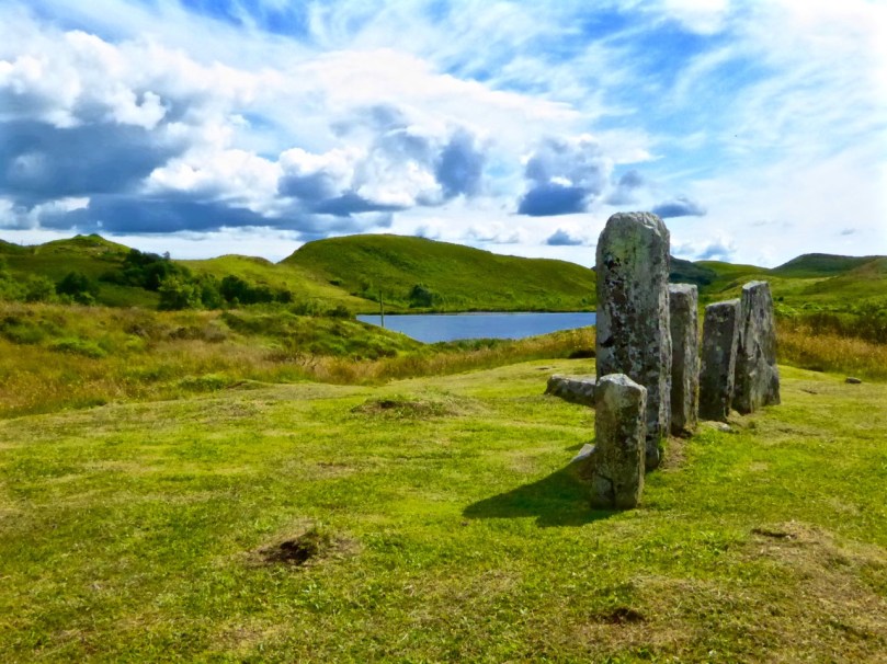
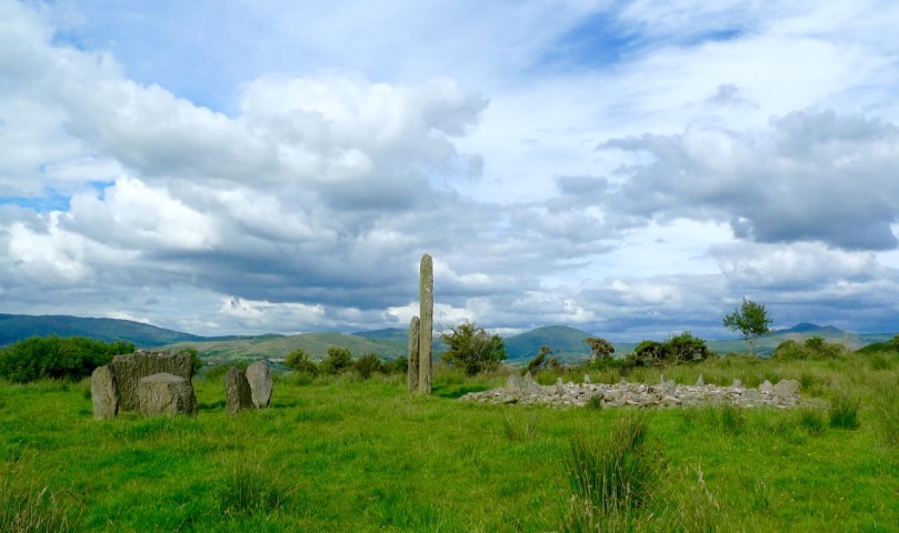
You can see both the multiple stone circle (the closer set of stones) and the 5-stone circle and stone row from the knoll near the site

But none of this is obvious on the ground and there are no explanatory signs, so I’m going to lay out what we know about this marvellous complex of monuments, so that when you go (Yes, do go!) you’ll know a bit more about what you are looking at. Make it part of a day trip, like the one that Robert is describing this week.

Park in the little car park about 2 km west of the turn off for Derreen Garden. Someone has handily marked it on Google Maps as ‘Parking Place Stone Circle’ and take the path that runs upwards through the woods, turning left (and ever upwards) when you come to another path. It’s a Robert Frost experience – the woods are not only lovely, dark and deep but also mossy and mysterious, with hints of old walls here and there.

When you emerge into open country, you are actually on the Beara Way and this stretch was beautifully described by Peter Clarke in his Hikelines blog.

Peter Clarke’s sketch of the 5-stone circle and stone row ©Peter Clarke/Hikelines

In fact, you are walking now along or beside a medieval road that once ran from Kenmare to Castletownbere. Once you know this, you can pick it out and imagine walking or riding along it in rough woollen garments, or perhaps the  flowing robes of a monk, or the full armour of a knight. But this road is actually one of the newer items in this landscape.

The landscape itself is Bronze Age. People made their living here by growing some cereals (probably barley and emmer wheat) and by herding cattle and sheep. Pollen analysis tells us that forest cover declined – that is, it was cleared by the early agriculturalists – beginning about 1500BC and intensifying around 1100BC. Pre-bog field systems are everywhere here – look for the lines of upright boulders defining walls and small fields as you walk.

According to Billy O’Brien in his Iverni (got your copy yet?) deterioration in the climate and higher rainfall about 1000BC led to increased acidification and the spread of bogs in many areas. So what we are looking at here, in the Mid to Late Bronze Age, is an open pastoral landscape. This is important because the views from here are panoramic and significant, and they would not have been obscured by trees.

Ancient fields

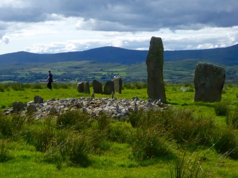
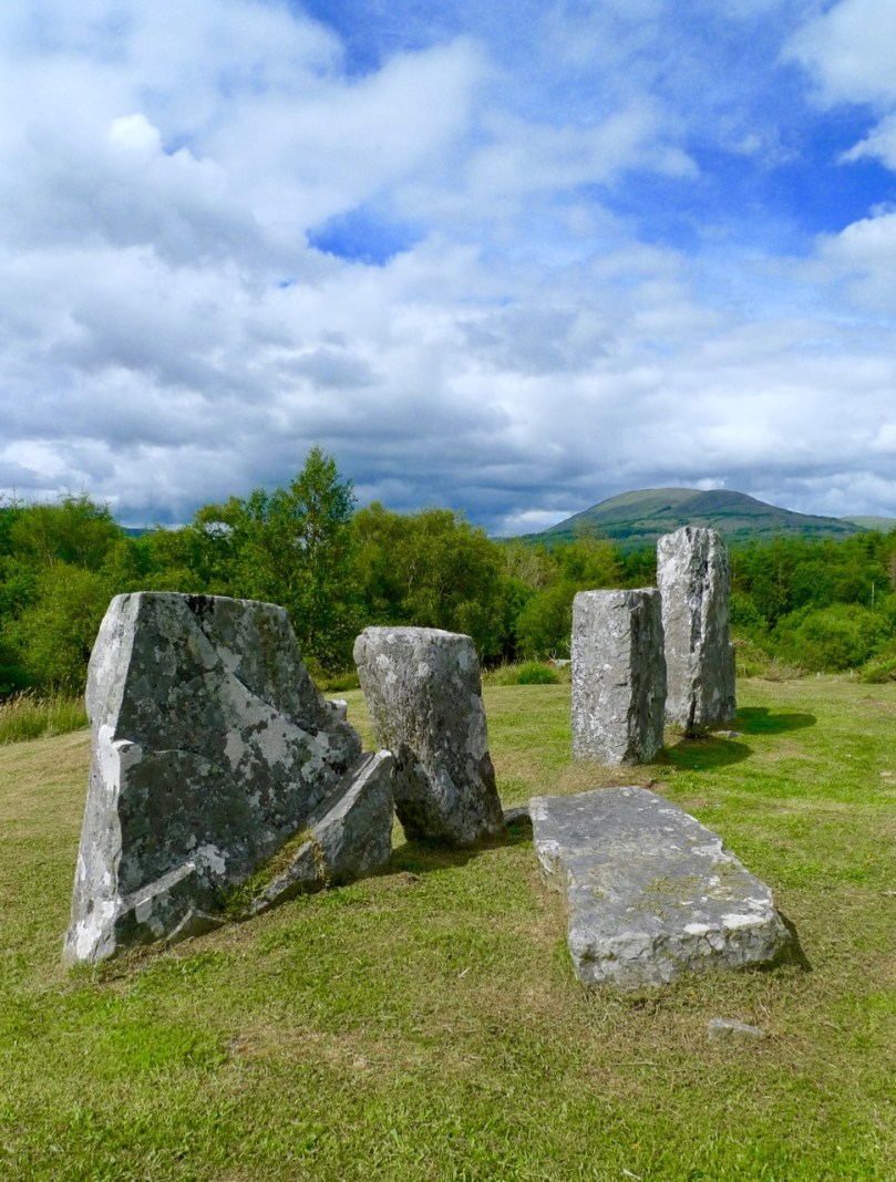
And in this open landscape these early farmers lived in houses of which no traces remain, probably of wood and thatch. What does remain are the monuments they built of stone – they meant them to endure and endure they do. There’s a five-stone circle, and a stone row right beside it, and about 30 metres to the west another set of upright stones.

The stone row was built before the 5-stone circle, possible hundreds of years before. There are three stones now, but the Lynch excavation established that there had been a fourth. Like most of  the stone rows on this part of the world it is oriented ENE/WSW, or towards the morning and evening horizons in summer. As regular readers know, I am always intrigued by the way the shapes of the stones seem to mirror the landscape behind it and this is no exception.

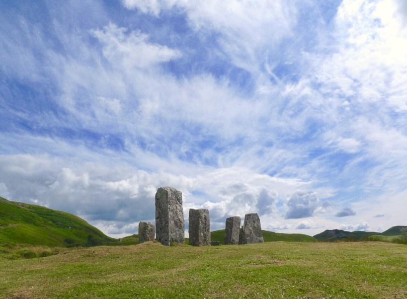
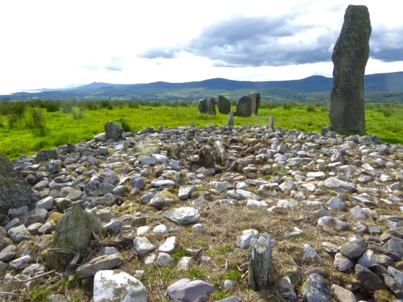
The 5-stone circle now only has three stones, but the sockets for the remaining two were found in the course of the excavations. In the centre, covered by a stone slab, was the cremated remains of a person in his or her 20s. Radio carbon dates (later re-calibrated) established the construction to about 1300 to 700BC, placing it in the Late Bronze Age. Mike Wilson of the Mega-WHAT site has analysed the orientations of both the stone row and the 5-stone circle – you can see the results of that here.

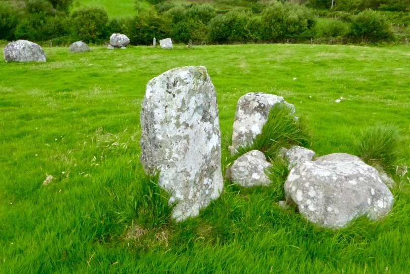
Visitors love to leave little offerings at sites like this. You are looking into the 5-stone circle, towards the recumbent. The slab is more or less where the cremated remains were discovered in the excavation

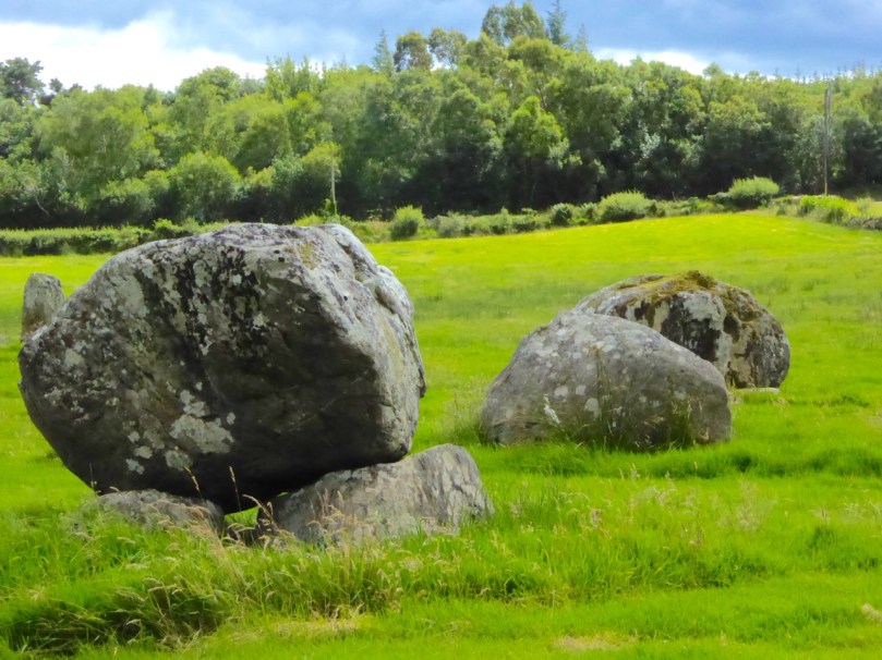
From here you can clearly see another set of stones to the west. What looks like another stone row is actually the remaining uprights of a multiple stone circle, as Anne Lynch documented in her account of the excavation. There were either 11 or 13 stones originally. The tallest stone now standing must have been one of the portals. The middle stone was originally lying down but was re-erected in the course of the excavation.

Once again, I am struck by how these three stones appear to mirror the horizon behind them. Can this really be a coincidence? If so, it’s a an eerie one. To understand how and why multiple stone circles were built, start by reading The Stone Circles of West Cork: Discussion. That post will point you to others as well.

To round out the Bronze Age monuments, there’s a Fulacht Fia just south of the 5-stone circle – you can read more about these ancient cooking places in my post Ballyrisode Fulacht Fia.

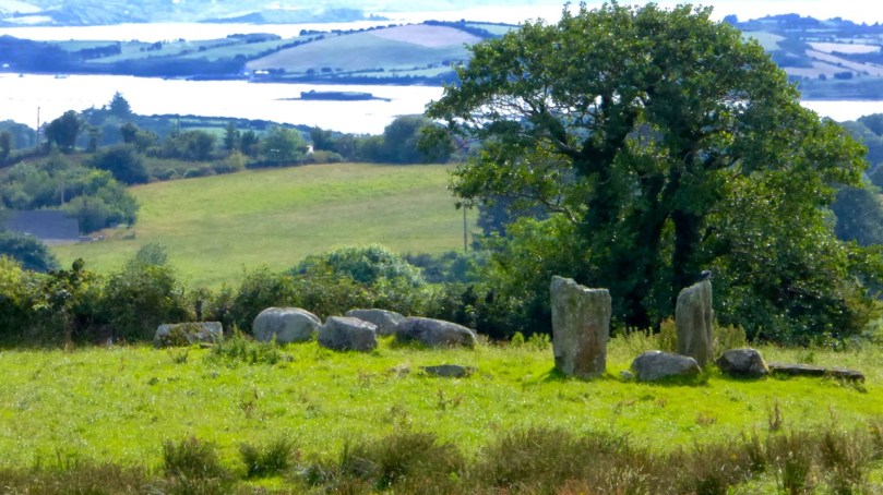
This little road leads to a stone building, perhaps originally a cottage. It’s the green roof you can see in the second photograph

Cashelkeelty is an amazing site – so many monuments, such evidence of Bronze Age activity from daily living and farming to monument-building. We still have their stone edifices to remind us that these people were sophisticated builders who wanted certain of their practices and rituals to endure for centuries. What we no longer see easy signs of, we can imagine – the forest clearing, the planting and herding, the communal feasting. Take a little while at this site and ask whether our own efforts will endure for thousands of years.

Family-Friendly Archaeology

Dramatic Skies over Maughanasilly Stone Row

Dramatic Skies over Maughanasilly Stone Row

West Cork is crammed with prehistoric monuments but many are not really accessible for all family members because of the terrain. Others are on private land where the landowner is reluctant to grant permission, or where frisky bullocks make traversing a field a bit risky. So we’ve done some homework on easy-to-reach sites and planned a route for you in which you can have a) a Grand Day Out and b) a tour through some of the best West Cork Bronze Age sites and one Medieval Castle.

The Kealkill complex: one of the sites you'll visit today

The Kealkill complex: one of the sites you’ll visit today

Load the kids and Grandma into the car, stick Discovery Map 85 in your pocket (or use the one we’ve provided in this post), wear boots or wellies, and off you go! By the way, we strongly advise leaving the dog at home when on a field trip like this. If you must bring him, please keep him on a leash, since you will be on private farmland at each site except Carriganass.

This slideshow requires JavaScript.

Oh – and the frisky cattle? Keep an eye out – they weren’t around when we did our reconnaisance but you never know when that can change. These two photos are by Amanda Clarke, used with permission.

Kealkill Monuments

Our starting point is Ballylicky – here’s your opportunity to pick up a picnic at the marvellous Manning’s Emporium. And if you like your day today, consider signing up for one of their Culture Kitchen tours – an innovative mix of history, prehistory and artisan food that will lead you still further into the prehistoric (and culinary) hinterland of West Cork.

Mill Little Group of Munuments

Mill Little Group of Monuments

1. Mill Little Complex

From Ballylicky, head west along the scenic seaside road towards Glengarriff for a couple of kilometres and take the first turn right at Snave. You’ll be following the Coomhola Rive as it tumbles down between high hills. Once you’ve crossed Snave Bridge continue for about a km, take the second left and then immediately right. One km on, take a left and then the next right. Park along here and the Mill Little complex is in a field on the left.

Stone Pair

Stone Pair

This is a complicated site, comprising a stone pair (don’t be confused by the other stones around the pair, which have been piled here), three boulder burials, and a small five-stone circle. All these monuments probably date from around the same time – the Bronze Age, about three to four thousand years ago. A particular feature of West Cork archaeology is that boulder burials, standing stones (single, in pairs, or in rows) and stone circles are often found together. Stone circles and stone rows are oriented towards significant solar events, such as the rising solstice sun or the setting sun at an equinox. At a site like this, it is possible that all the features formed a large observational arena, with the stone row, boulder burial and stone circle providing multiple alignment possibilities and marking both solar and lunar events.

Boulder burial showing support stones. Five-stone circle in the background

Boulder burial showing support stones. Five-stone circle in the background

The boulder burial nearest the stone circle is the most classic in appearance – a large glacial erratic sitting on top of three support stones. Excavations at boulder burials in West Cork, however, haven’t really yielded evidence of actual burials – perhaps the term is a misnomer!

Three boulder burials at Mill Little

Three boulder burials at Mill Little

2. Carriganass Castle

Retrace your steps back towards Ballylicky and take the road to Kealkill – or try an overland route using the map. At Kealkill take the left fork signposted to Gougane Barra and you will see Carriganass Castle almost right away.

Carriganass Castle

Carriganass is an excellent example of the medieval tower house – take a look at this post for more about these structures in West Cork. There’s easy parking around the back and lots of explanatory signs around the castle. This is a good place for a picnic, or you can wait until after you’ve been to Maughanasilly, since you will come back this way. If it’s a hot day (don’t laugh – it can happen!) the kids will enjoy a dip in the river here. There are also some looped walks starting from here – mark them for a future expore.

3. Maughanasilly Stone Row

Continue past the back of the castle. At the first junction take the left fork and continue until you see a small lake on your left. Shortly after you will come to a cross roads. Turn right and park – the stone row is in the field on your right.

Maughanasilly Stone row. Note the row forms a slight arc

Maughanasilly Stone row. Note the row forms a slight arc

This is a good example of a multiple stone row and occupies a very dramatic setting on a knoll overlooking the lake. Note that, instead of being straight, the stones form a slight arc. This is deliberate, as is the placement of the stone lying flat on the ground. According to one expert, this stone “is placed so that anyone walking up to it and standing with toes touching its edge is looking straight at the equinox.” This stone row also appears to have been an important one for lunar observations. It takes the moon over 18 years to complete its cycle and from this site observations of the lunar maximums (the most extreme northerly and southerly moonrises) were likely made.

The stone row with recumbent stone

The stone row with recumbent stone

Ponder on the sophistication of our Bronze-Age ancestors: much of the knowledge they built up so that they could keep track of time and seasons had to be re-learned by later people.

Maughanasilly Stone row  - a lunar observatory?

Maughanasilly Stone row – a lunar observatory?

4. Kealkill Stone Circle

Back you go to Carriganass (picnic now, if you haven’t done so already) and on to the village of Kealkill – a pretty and well-kept village (and home to a famous St Patrick’s Day parade). The stone circle is signposted from the village – just follow the steep and winding road that runs up from the church. After a sharp bend to the right, take the first left turn. There’s enough room to park at a small pull-out. The walk across the field to the circle is invariably muddy and squelchy so make sure to wear your boots here.

Kealkill standing stone pair, stone circle and radial cairn

Kealkill standing stone pair, stone circle and radial cairn

This is yet another complicated site. There is a standing stone pair, a five-stone circle and a radial cairn. But perhaps the first thing you will notice is the spectacular view. From this spot you can see all the way down the spine of both the Sheep’s Head and the Beara Peninsula to the South-West, and across the valley to the Shehy Range to the North and East.

From the Kealkill Site

From the Kealkill Site

One of the stone pair is over 4m high. But it’s broken – and may originally have stood over 6m high.  Imagine the difficulty of erecting this!

The first thing you notice - that standing stone!

The first thing you notice – that standing stone!

The radial cairn is a mysterious monument – nobody is quite sure of its function – and relatively rare. Once again, these cairns are often found in conjunction with other monuments – stone alignments or stone circles. This one was excavated, but nothing conclusive was found to help determine its function. Note the small upright projecting stones that look like the face of a clock among the cairn stones.

Kealkill radial cairn

Kealkill radial cairn

5. Breeny More Stone Circle and Boulder Burials

This is just a little way up from the Kealkill circle and on the other side of the road. We haven’t had time to visit it properly yet, so my photograph was taken from near the road. There’s a multiple stone circle here, with four boulder burials within it. There’s not much left of the stone circle, but the portal stones and recumbent remain, so the alignment can be discerned. The boulder burials are laid out in square formation in the centre – a very unusual occurrence, since boulder burials are normally outside the circle. The site is on a natural ridge, with similar spectacular views to the Kealkill Stone Circle. One writer has speculated that if trees were removed it would be possible to see the tall standing stone at Kealkill from this site.

Breeny More complex from the road

Breeny More complex from the road

We hope you enjoy your day! Let us know how you got on.

Monoliths, Mysteries and Marriages

"The Fingers" on the skyline

‘The Fingers’ on the skyline

All across West Cork – in the middle of pastureland, in isolated bogs, on the tops of mountains – you see standing stones. Mostly single but also found in pairs, or rows of three or more, they are as ubiquitous as they are mysterious. A scan of the Ordnance Survey map of the valleys running eastwards from Bantry, just north of us, shows a great proliferation of standing stones, and we have been tempted into the field often to hunt for them. We usually find them, but even when we don’t the search brings us into magnificent countryside.

Standing Stone Country

Standing stone country, east of Bantry Bay

The most numerous are, of course, single standing stones. The practice of erecting monoliths dates from the Neolithic and many of the stones we see may indeed be as old as that, or Bronze Age. Some may be medieval or more recent still – local people occasionally have memories of a grandfather placing a stone to act as a cattle scratching post.

Bishop's Luck Stone - wonder what's under this one?

Bishop’s Luck Stone – wonder what’s under this one?

If the stone has rock art on its surface, as is the case with the Burgatia stone near Rosscarbery, for example, we can safely conclude that it’s probably Bronze Age. Ogham incisions, or an inscribed cross will assist with an Early Medieval date. But the vast majority are unmarked and their functions may have varied. Some excavated examples have yielded evidence of burials at the base, and some seem to mark boundaries or entrances to mountain routeways.

Stone pairs and stone rows often occur in close proximity to other Bronze Age monuments such as stone circles and boulder burials. Some are further away from the monument but clearly visible from it.

Like the stone circles, the pair or row has an alignment – generally northeast/southwest, and a further alignment is formed from the two to the boulder burial or stone circle.

Irish folklore is rife with stories about standing stones. Many were said to have been hurled there from a nearby mountain by Finn McCool. Kevin Dannaher in his book Irish Customs and Beliefs relates several instances of petrification. Here’s an example:

…our early saints are…credited with passing fits of choler during which several miscreants were rendered harmless…When St Fiachna discovered that a dairy woman was stealing his butter he did not hesitate to loose a mighty curse against her, which turned not only herself, but her dairy and all her utensils as well, into stone. In proof of which they are still plain to be seen close to the saint’s church at Teampal Fiachna, a few miles south east of Kenmare.

The Three Fingers at Gurranes, near Castletownshend, probably once a row of five or six stones

The Three Fingers at Gurranes, near Castletownshend, probably once a row of five or six stones

One kind of standing stone is particularly intriguing – the holed stone. Tradition has it that these are marriage stones: the couple would join hands through the hole to exchange vows. 

*Both holed stone photographs are by Amanda Clarke