The Stone Circles of West Cork: Five-Stone Circles

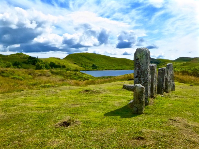
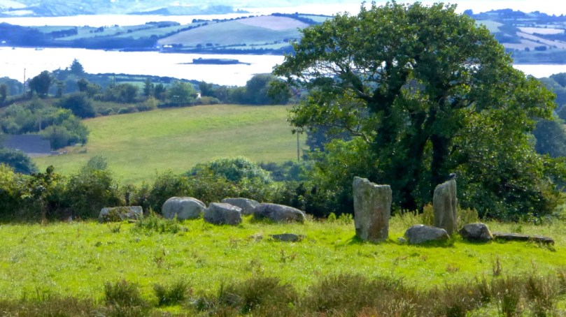
About half of the stone circles in the Cork-Kerry complex consist of only five stones, and constitute a sub-group know as Five-stone Circles. While they share many similarities with the Multiple-stone Circles, they are a unique class of monument. I’ve described the Multiples in detail here, so if you need to refresh your memory about that group, you can do it now and then come back and read on. While most of the photographs in this post are my own, I gratefully acknowledge the generosity of Ej Carr in allowing me to use two images (above and the last one in the post) of the Uragh Five-stone Circle and Standing Stone and of Peter Clarke for his drawing of the circle at Cashelkeelty (below).

Most strikingly, the Five-stone Circles follow the pattern of the larger ones in having two portal stones, usually the tallest orthostat of the circle, across from a recumbent, or axial stone which is usually the shortest. In describing them here, I am following the work of Seán Ó Núalláin, who surveyed and described all the Cork-Kerry Stone Circles in 1975. While his comprehensive paper is  45 years old, it is still the most complete work on the Stone Circles of Cork and Kerry (The Journal of the Royal Society of Antiquaries of Ireland, Vol. 105 (1975), pp. 83-131). 

Lettergorman, with its large block of sparkling quartz

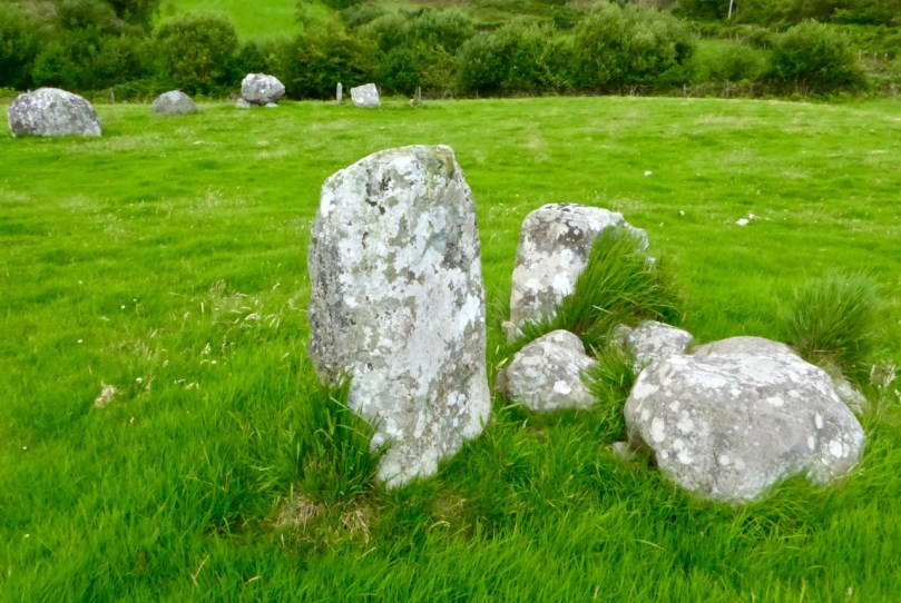
Most of the Five-stone Circles I have seen now are complete or almost complete, although some of the orthostats have fallen. They are actually in remarkably good condition – perhaps their small size has offered them some protection against the need to ‘improve’ farmland. some have been filled in with field stones but most are simply marooned in little islands of grass in the middle of a field, occasionally with a protective fence to keep cattle away.

Glanbrack, at the top of a small hill with views to all sides. This is one of the ones that Ó Núalláin thinks may have only ever had three stones. Note the two outliers

Two of the Five-stone Circles may in fact, according to Ó Núalláin, be actually Three-stone – it is assumed that both Cashelkeelty and Glanbrack had two more stones originally, but he muses that a setting of three stones could be seen as representing the ultimate degeneration of the “circle” concept.

This is Clodagh Five-stone Circle, also with two outliers immediately outside the circle. There is another standing stone pair nearby

Neither are they truly circular – in fact they are mostly D-shaped, with the axial stone being the straight edge of the D. This is a function of their size – the axial stone, with its straight edge, represents a much bigger proportion of the circle that it would in a large Multiple-stone Circle, but it also brings up the issue of whether the circle shape is truly essential to the functions of this type of monument.

Hard to make out exactly what’s what at Inchybegga Five-stone Circle, since the stones are small and the circle is disturbed and filled with field stones

The axis of the Five-stone Circles, that is, the direction of a line drawn between the portal stones across the recumbent, is generally NE/SW. This orientation is not exact, but most fall within a few degrees of it. Ó Núalláin agrees with Aubrey Burl in his analysis of the Scottish circles (and our own observations at the circles confirm this) when he says

Thus the circles are so aligned that the entrances face the side of the heavens on which the sun rises and the axial stones face the setting sun. The broad splay present, 107 degrees, suggests that a general alignment on the side of the heavens on which the sun rises or sets was what was required, and that precise alignments on specific celestial events were not in question. It is worth noting however that the axial stones tend to group in a sector indicating a winter rather than a summer position.


This intriguing site is Derryarkane Five-stone Circle. It is dominated by a Whitethorn Tree, traditionally never cut or interfered with. Under the tree the circle is complete although one of the portals has fallen. Robert is standing at an outlier about 35 metres away

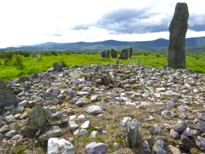
As with the Multiple-stone Circles, there are peripheral monuments associated with Five-stone Circles – standing stones, stone pairs, stone alignments, quartz blocks, radial cairns, and in once case (Mill Little) boulder burials. None of these are inside the circle so are referred to as outliers.

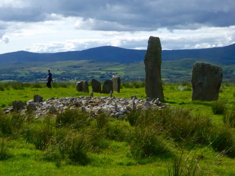
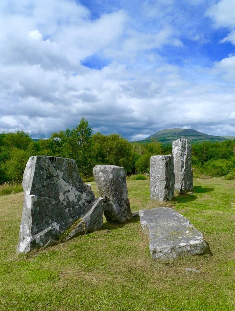
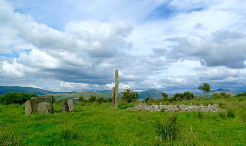
One of the most complex of the Five-stone Circle sites is Kealkill (above), which includes two large standing stones (one of them is truly enormous) and a radial stone cairn.

Another complicated site is Cashelkeelty. Here (above) we see the Five-Stone Circle (although it may be the second of Ó Núalláin’s Three-stone Circles), a row of three stones to the left, and in the distance orthostats of what may have been a Multiple-stone Circle

There are two Five-stone Circles in the townland of Baurgorm. This one (above), the more northerly of the the two, has two outliers but only one is visible in this photo as the other has fallen. There are two other standing stone recorded nearby but we could not find them. The portal stones are unusually far apart in this circle.

This is the second of the Baurgorm circles and from it are visible this group of stones – a standing stone row (three stones of which only two are visible from where we were and of which one of the stones is split) and a single standing stone.

This is the Mill Little Complex which comprises a Five-stone Circle (visible to the right of and behind Simon Tuite of Monumental Ireland), a standing stone pair (foreground, with field stones around them) and three Boulder Burials. While there are many example of Multiple-stone Circles in association with Boulder Burials, it’s unusual to see them alongside the Five-stone Circles.

Ó Núalláin finds the morphology (size and shape) of the stones unremarkable, apart from noting that the stones in individual monuments are roughly similar in size and shape. However, there is a little more to say about it than that. While the recumbent is invariably flat-topped, the flanking stones can vary from a gently rounded curve, to a slant, to what looks like a deliberately shaped angular peak. Have they been chosen, or shaped, with some purpose in mind? Two examples (above and below) are shown here where the right flanking stone (to the right of the recumbent) appears to have been chosen for its pointed shape. The first is Cappaboy Beg, the smallest of the Five-stone Circles and the second is Inchireagh.

Even though the recumbent is usually the lowest stone in the circle, it’s not always the case. At Kealkill (below), for example, the recumbent is easily the largest and most dominant of the five stones.

We cannot rely on archaeological evidence to reveal more about the nature and purpose of the Five-stone Circles. Only one has been scientifically excavated – the one that is part of the Kealkill complex. No burials or deposits were found. A one-day dig in the 1930’s at another site, Knocknakilla, revealed a sort of flat-stoned pavement in the interior, with lots of quartz fragments. Obviously this will be a fertile field for some future researcher.

Glanbrack (above) has cupmarks on the top surface of the recumbent. Our second photograph, taken from the further of the two outliers, reminded us that on the day we visited the field had been half-spread with slurry (we held our noses). While we were engrossed in our photographing and observing, we suddenly became aware that the tractor had arrived at the gate (can you see it?) to do the second half. We hot-footed it out of there!

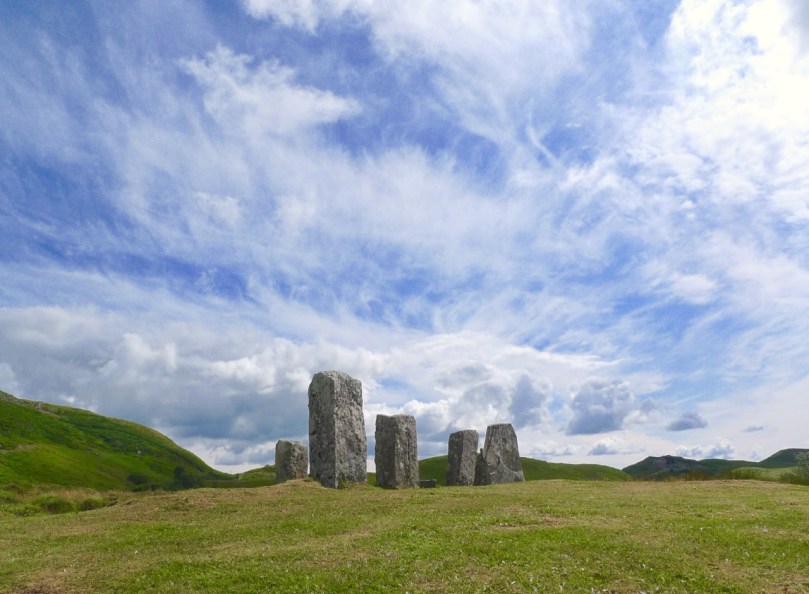
One thing we have noticed from our visits is that the Five-stone circles are differently situated from the Multiple-stone circles. Whereas Multiple-stone Circles are often on a bench on a hillside, with wide views in one direction and rising ground in the other directions (Drombeg is typical), Five-stone circles are often on flat ground in a valley or at the top of slight eminences (like Cullomane, above, and Cappaboy Beg and Inchireagh below) but usually with panoramic views all around. While we have noted this casually, we would need to go back and check these observations more carefully before being too categorical about them.

In my next post in this series I will get started on the Discussion – what conclusions can be drawn about the nature and purpose of Stone Circles? What do we know about who built them and why? And once again, thank you to Ej Carr for this superb shot of Uragh.


Anomalies

The cairn

What’s an archaeological anomaly? When the National Monuments Survey was being undertaken, some stone structures didn’t quite fit the description of a particular class of monument. They may have been ancient – but how ancient, and what exactly were they? The term chosen for such mysterious piles  was ‘anomalous stone group’. Here’s the definition: A group of stones, usually standing, which cannot be classified as any other known archaeological monument type on present evidence. They may be all that remains or is visible of a partially destroyed or obscured archaeological monument which may date to any period from prehistory onwards.

cupmarked rocks?

Just a leaning rock?

But it’s not the only term used for uncertain monuments: enclosure is a vague term that can mean a multitude of things, and an ‘unclassified cairn‘ can be defined simply as a heap or pile of stones. In the last few months our explorations of the Sheep’s Head have turned up several anomalies. The only thing they all have in common is their spectacular siting, leading to an ultra-rewarding field trip.

Heading towards the cairn

Hiking to the cairn

Perhaps the most magnificently situated of all is the unclassified cairn on the mountain ridge above Kilcrohane. It’s right on the way-marked Sheep’s Head Way, so it’s easy to find. While it’s described as a cairn in the National Monuments inventory, it could be as humble an object as a turf storage platform or as wonderful as a passage grave. We’ve been to it several times and always puzzled over it, but on our last visit we were alerted to a new element by Amanda and Peter.

Amanda investigates

The ‘new element’ – you have to really look!

A couple of stones had shifted, possibly in storms, and we could now delve deeper into the pile of rocks and see that one of them had a large circular opening in it. Very strange – I had never seen anything like it – and very intriguing.

Curious ‘holed stone’ at the bottom of the cairn

We noted that the highest point on Cape Clear was visible across the water, the hill on which a ‘real’ passage grave sits. Only excavation is likely to reveal the exact nature of this anomaly.

What's the orientation?

This one is called an ‘anomalous stone group’

Not too far away, in the same townland but on lower ground, is an anomalous stone group. This is a strange one indeed because half of it looks for all the world like a stone circle – identical to the numerous recumbent or axial circles that dot West Cork. The other half? It’s the rock face that the stones obviously came from.

Is it a stone circe?

Could swear that’s a classic recumbent, but where’s the other half of the circle?

It’s like a work in progress. If it is a stone circle, the builders decided that half a one would do the job just fine. Indeed the owner of the land has noted several significant  sunset alignments.

possible alignments

There seem to be several alignments – this one to the Beara Peninsula

But when I asked for comments on an archaeological social network site the general consensus seemed to be that it was unlikely to be a stone circle, since the stone face obscured half the horizon. But that same stone face would have provided shelter, so the speculation in the discussion centred on this being a hut site, with only some of the stones of the outside wall remaining.

radial cairn?

This area of rough ground to the right of Robert, Peter and Amanda is labelled an ‘Enclosure’

The third site we’ve explored is described as an enclosure. The description of the site states: A circular area (diam. 10.5m) is defined by the remains of a stone wall (T 1.3m; H 0.5m) displaying traces of an inner and outer row of large stones with a fill of smaller stones. A stone slab (H 1.15m; L 0.5m; T 0.4m) narrowing as it rises stands on the external perimeter at E. There is also a standing stone a few meters to the south.

inner row?

Difficult to make out what’s here, but it seems like there’s a lot going on

This could be a radial cairn – take a look at the one at Kealkill to see what we mean. But equally, the description hints, it may have to do with field clearance. It’s almost impossible to tell a lot from the general jumble of stones and the furze and brambles that grow all over the site. Once again, however, we were rewarded with panoramic views to the Beara Peninsula. Another one where only an excavation will reveal the truth.

View east from the enclosure

And these views of the farms to the east, lit by a shaft of slanting sun

Finally, we trekked out on the Lighthouse Loop Walk at the very end of the peninsula in search of possible cupmarks, discovered by Peter and Amanda’s son.

Lighthouse trail, looking back

On the lighthouse loop trail, looking back

The cupmarks turned out, we’re pretty sure, to be natural solution pits. There were lots of them, of varying sizes, and some could only be viewed by lying on your back.

The pitted boulders

The ‘cupmarks’ are on the underside of the leaning rock

Instructive, though, as we have certainly seen cupmarked stones that don’t look a whole lot different than these ones – there’s a type of shaley sandstone in West Cork that laminates in a very similar manner when carved.

Solution pits

pits all aroundSolution pits – and modern graffiti 

In West Cork, monuments that don’t fit into satisfying categories abound – and it’s just as much fun exploring them as it is the ‘normal’ type!

tough to take

This kind of field trip is tough to take!

Family-Friendly Archaeology

Dramatic Skies over Maughanasilly Stone Row

Dramatic Skies over Maughanasilly Stone Row

West Cork is crammed with prehistoric monuments but many are not really accessible for all family members because of the terrain. Others are on private land where the landowner is reluctant to grant permission, or where frisky bullocks make traversing a field a bit risky. So we’ve done some homework on easy-to-reach sites and planned a route for you in which you can have a) a Grand Day Out and b) a tour through some of the best West Cork Bronze Age sites and one Medieval Castle.

The Kealkill complex: one of the sites you'll visit today

The Kealkill complex: one of the sites you’ll visit today

Load the kids and Grandma into the car, stick Discovery Map 85 in your pocket (or use the one we’ve provided in this post), wear boots or wellies, and off you go! By the way, we strongly advise leaving the dog at home when on a field trip like this. If you must bring him, please keep him on a leash, since you will be on private farmland at each site except Carriganass.

This slideshow requires JavaScript.

Oh – and the frisky cattle? Keep an eye out – they weren’t around when we did our reconnaisance but you never know when that can change. These two photos are by Amanda Clarke, used with permission.

Kealkill Monuments

Our starting point is Ballylicky – here’s your opportunity to pick up a picnic at the marvellous Manning’s Emporium. And if you like your day today, consider signing up for one of their Culture Kitchen tours – an innovative mix of history, prehistory and artisan food that will lead you still further into the prehistoric (and culinary) hinterland of West Cork.

Mill Little Group of Munuments

Mill Little Group of Monuments

1. Mill Little Complex

From Ballylicky, head west along the scenic seaside road towards Glengarriff for a couple of kilometres and take the first turn right at Snave. You’ll be following the Coomhola Rive as it tumbles down between high hills. Once you’ve crossed Snave Bridge continue for about a km, take the second left and then immediately right. One km on, take a left and then the next right. Park along here and the Mill Little complex is in a field on the left.

Stone Pair

Stone Pair

This is a complicated site, comprising a stone pair (don’t be confused by the other stones around the pair, which have been piled here), three boulder burials, and a small five-stone circle. All these monuments probably date from around the same time – the Bronze Age, about three to four thousand years ago. A particular feature of West Cork archaeology is that boulder burials, standing stones (single, in pairs, or in rows) and stone circles are often found together. Stone circles and stone rows are oriented towards significant solar events, such as the rising solstice sun or the setting sun at an equinox. At a site like this, it is possible that all the features formed a large observational arena, with the stone row, boulder burial and stone circle providing multiple alignment possibilities and marking both solar and lunar events.

Boulder burial showing support stones. Five-stone circle in the background

Boulder burial showing support stones. Five-stone circle in the background

The boulder burial nearest the stone circle is the most classic in appearance – a large glacial erratic sitting on top of three support stones. Excavations at boulder burials in West Cork, however, haven’t really yielded evidence of actual burials – perhaps the term is a misnomer!

Three boulder burials at Mill Little

Three boulder burials at Mill Little

2. Carriganass Castle

Retrace your steps back towards Ballylicky and take the road to Kealkill – or try an overland route using the map. At Kealkill take the left fork signposted to Gougane Barra and you will see Carriganass Castle almost right away.

Carriganass Castle

Carriganass is an excellent example of the medieval tower house – take a look at this post for more about these structures in West Cork. There’s easy parking around the back and lots of explanatory signs around the castle. This is a good place for a picnic, or you can wait until after you’ve been to Maughanasilly, since you will come back this way. If it’s a hot day (don’t laugh – it can happen!) the kids will enjoy a dip in the river here. There are also some looped walks starting from here – mark them for a future expore.

3. Maughanasilly Stone Row

Continue past the back of the castle. At the first junction take the left fork and continue until you see a small lake on your left. Shortly after you will come to a cross roads. Turn right and park – the stone row is in the field on your right.

Maughanasilly Stone row. Note the row forms a slight arc

Maughanasilly Stone row. Note the row forms a slight arc

This is a good example of a multiple stone row and occupies a very dramatic setting on a knoll overlooking the lake. Note that, instead of being straight, the stones form a slight arc. This is deliberate, as is the placement of the stone lying flat on the ground. According to one expert, this stone “is placed so that anyone walking up to it and standing with toes touching its edge is looking straight at the equinox.” This stone row also appears to have been an important one for lunar observations. It takes the moon over 18 years to complete its cycle and from this site observations of the lunar maximums (the most extreme northerly and southerly moonrises) were likely made.

The stone row with recumbent stone

The stone row with recumbent stone

Ponder on the sophistication of our Bronze-Age ancestors: much of the knowledge they built up so that they could keep track of time and seasons had to be re-learned by later people.

Maughanasilly Stone row  - a lunar observatory?

Maughanasilly Stone row – a lunar observatory?

4. Kealkill Stone Circle

Back you go to Carriganass (picnic now, if you haven’t done so already) and on to the village of Kealkill – a pretty and well-kept village (and home to a famous St Patrick’s Day parade). The stone circle is signposted from the village – just follow the steep and winding road that runs up from the church. After a sharp bend to the right, take the first left turn. There’s enough room to park at a small pull-out. The walk across the field to the circle is invariably muddy and squelchy so make sure to wear your boots here.

Kealkill standing stone pair, stone circle and radial cairn

Kealkill standing stone pair, stone circle and radial cairn

This is yet another complicated site. There is a standing stone pair, a five-stone circle and a radial cairn. But perhaps the first thing you will notice is the spectacular view. From this spot you can see all the way down the spine of both the Sheep’s Head and the Beara Peninsula to the South-West, and across the valley to the Shehy Range to the North and East.

From the Kealkill Site

From the Kealkill Site

One of the stone pair is over 4m high. But it’s broken – and may originally have stood over 6m high.  Imagine the difficulty of erecting this!

The first thing you notice - that standing stone!

The first thing you notice – that standing stone!

The radial cairn is a mysterious monument – nobody is quite sure of its function – and relatively rare. Once again, these cairns are often found in conjunction with other monuments – stone alignments or stone circles. This one was excavated, but nothing conclusive was found to help determine its function. Note the small upright projecting stones that look like the face of a clock among the cairn stones.

Kealkill radial cairn

Kealkill radial cairn

5. Breeny More Stone Circle and Boulder Burials

This is just a little way up from the Kealkill circle and on the other side of the road. We haven’t had time to visit it properly yet, so my photograph was taken from near the road. There’s a multiple stone circle here, with four boulder burials within it. There’s not much left of the stone circle, but the portal stones and recumbent remain, so the alignment can be discerned. The boulder burials are laid out in square formation in the centre – a very unusual occurrence, since boulder burials are normally outside the circle. The site is on a natural ridge, with similar spectacular views to the Kealkill Stone Circle. One writer has speculated that if trees were removed it would be possible to see the tall standing stone at Kealkill from this site.

Breeny More complex from the road

Breeny More complex from the road

We hope you enjoy your day! Let us know how you got on.

Ancient Calendars

One of West Cork's ancient calendars

One of West Cork’s ancient calendars

We’ve been catching up on our rock art project this week and it’s brought us out into the field. On Saturday the weather was spectacular – crisp, but with a totally blue sky and vibrant colours. See Amanda’s photo of the day here. We spent most of the day just east of Rosscarbery, a picturesque settlement above the water at Rosscarbery Bay, where the birdlife viewing is always a delight.

One of the sites we visited was Bohonagh. Not only does it boast cupmarked stones, but a very fine boulder burial and a stone circle.

Bohonagh Stone Circle

Bohonagh Stone Circle

West Cork is particularly rich in 3000 year old Bronze Age stone circles and most of them are of the ‘axial’ or ‘recumbent’ type. This means that the circle is laid out on an axis that is oriented in a particular direction. On one side of the circle is a stone laid longways – the recumbent stone. Across from the recumbent are the portals: two tall stones that appear to create a doorway into the circle. Sometimes the stones rise in height from the recumbent to the portals, and the portal stones may be set ‘end-on’ to the circle. There are always, therefore, an uneven number of stones – up to 17 have been recorded, although many circles are incomplete, with fallen or missing stones. The purpose of the axis was to provide a line of sight on a sunrise or sunset (and perhaps even moonrise and moonset) at important calendrical points such as solstices and equinoxes.

The portal stones at Bohonagh

The portal stones at Bohonagh

Bohonagh quartz

Quartz at Bohonagh

A feature of these circles is that many of them include quartz rocks: sometimes as one of the circle stones, sometimes as an additional rock in the interior or exterior of the circle, and sometimes on a nearby monument such as a boulder burial. At Bohonagh there were several quartz rocks, including one lying outside the circle and two supporting the boulder burial. In one case, at Ballycommane, we have seen an enormous quartz rock function as the capstone of a boulder burial – quite awe-inspiring in its visual impact. Interestingly, this same phenomenon occurs in a stone circle in Cornwall – Boscawen-Un in the West Penwith Peninsula, not that far from West Cork! As we watched the quartz under the boulder burial glisten in the sun (impossible to capture on a photograph) we knew it had to be seen as a very special stone to the builders of these circles.

Brooding stones at Dunbeacon

Brooding stones at Dunbeacon

Stone circles often command sweeping views of the surrounding countryside. This makes them well worth visiting, even if a goodly hike is involved. Because they are invariably located on private land, it is good practice to try to track down the landowner and request permission, and of course to always close gates and observe good field etiquette on a visit. Don’t be surprised to find that many are no longer intact: the centuries have taken their toll and many of the stones have fallen or disappeared over time. On the upside, this adds to the romantic wildness of the scene.

Gorteanish Stone Circle, re-discovered in the laying out of  the Sheep's Head Way

Gorteanish Stone Circle, re-discovered in the laying out of the Sheep’s Head Way

One of the most famous of the West Cork stone circles is Drombeg, near Glandore. Here, people gather on the winter and summer solstices to witness sunrise and sunset.

Drombeg on a wet day

Drombeg on a wet day

At Bohonagh, the alignment is to the spring equinox sunrise and sunset, due east and west. We plan to be there!