Irish Romanesque 4: The Nuns’ Church at Clonmacnoise

It’s been a while since I wrote about Irish Romanesque architecture, but a recent visit to Clonmacnoise included a walk to an outlying site – the Nuns’ Church – which ranks as one of the gems of this form. 

If you’re new to this series of posts, you can bring yourself up to date with a quick read of previous posts, which will give you the background and vocabulary on this form of architecture – the dominant church building style of 12th century Ireland.

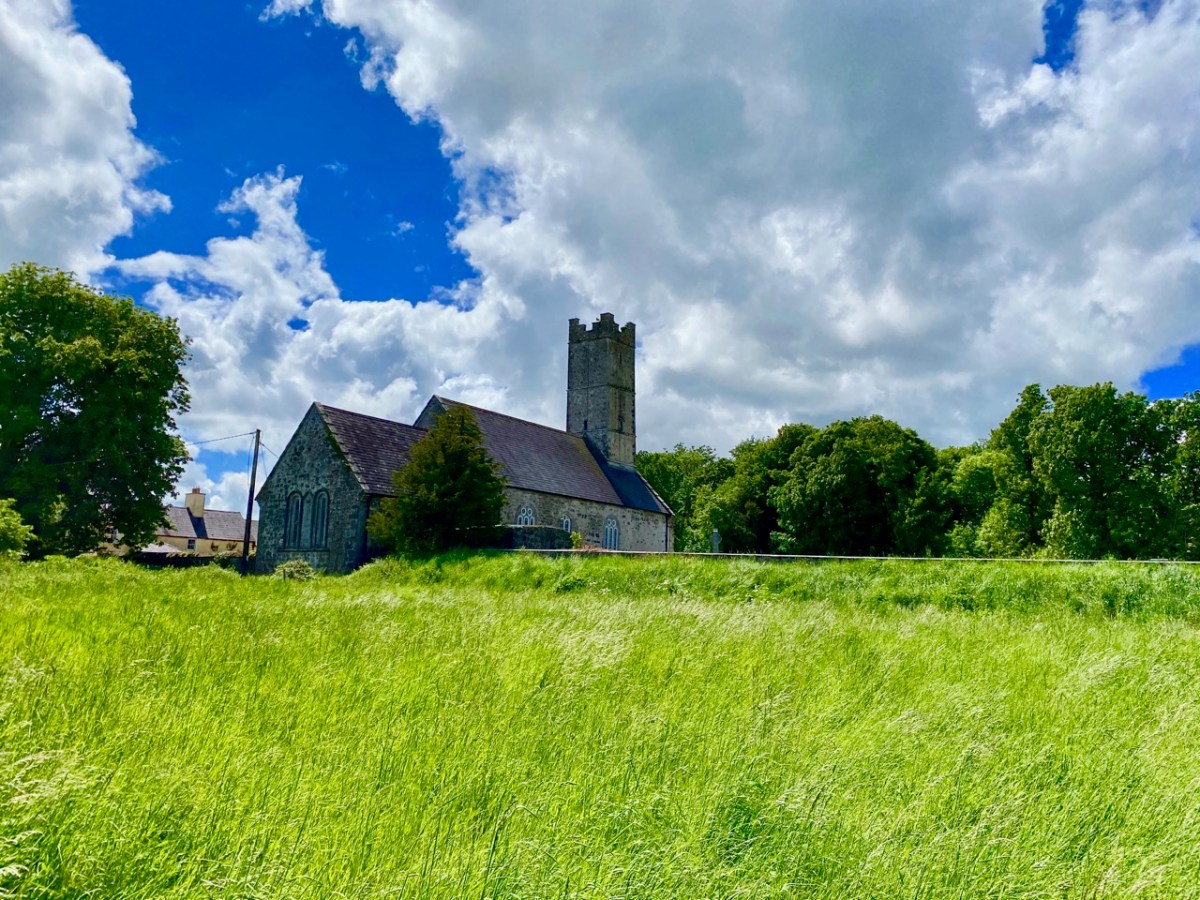
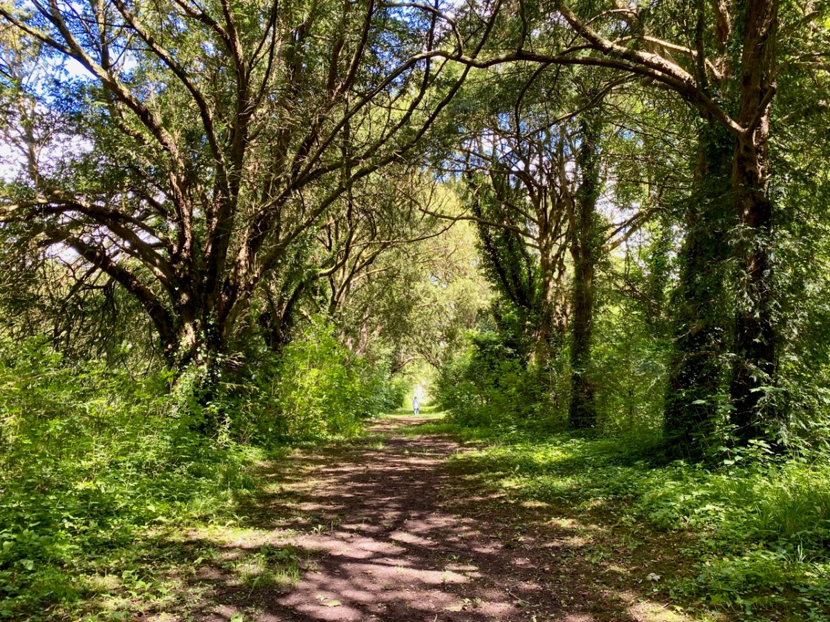
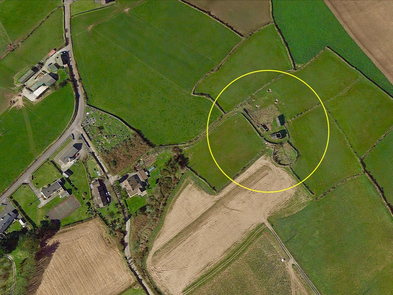
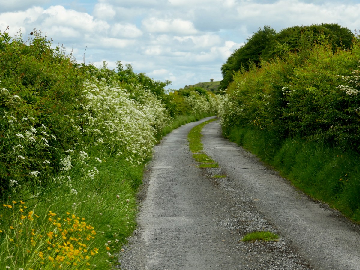
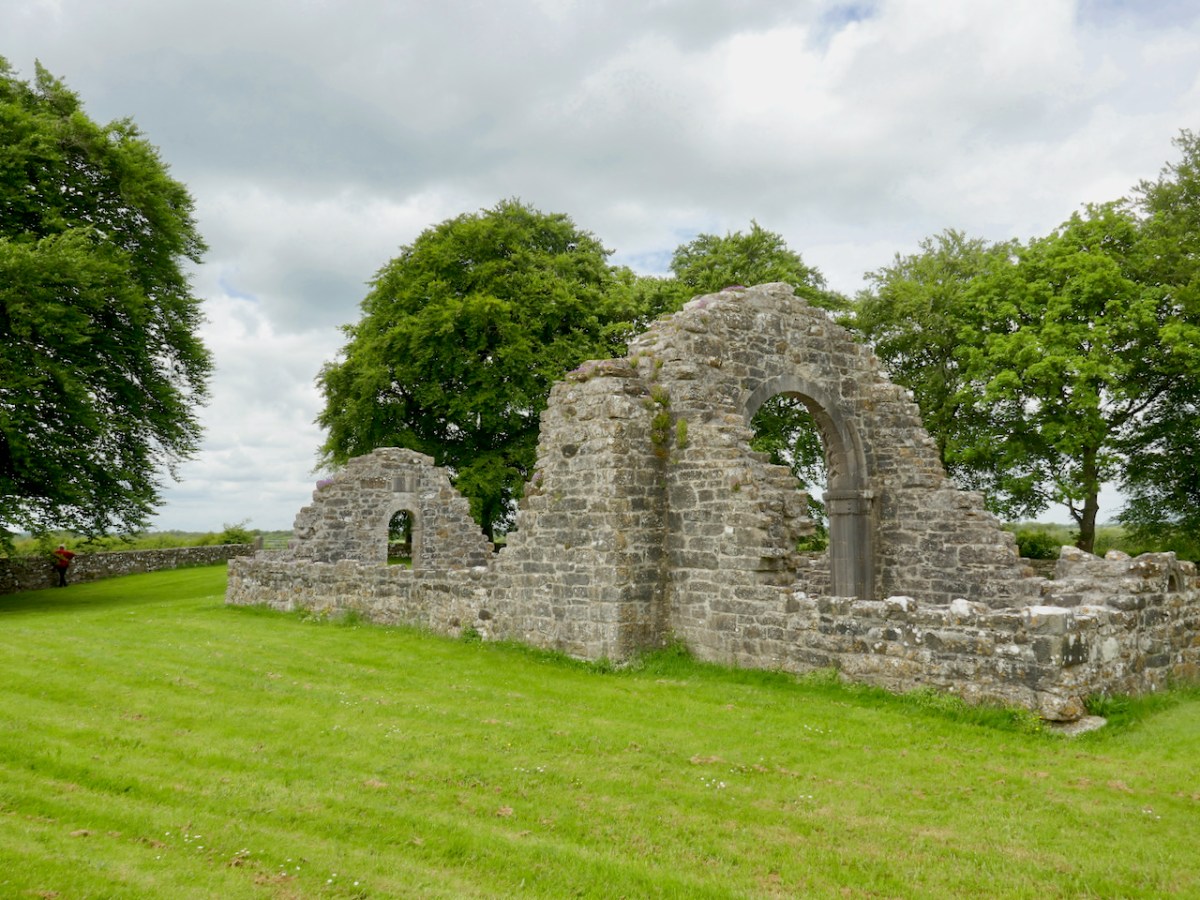
The Nuns’ Church was connected to the main monastery of Clonmacnoise by a causeway, still evident in places,  but is now reached by wandering along a boreen that, at this time of year, is delightfully fringed with Cow Parsely, Buttercups and Hawthorn.

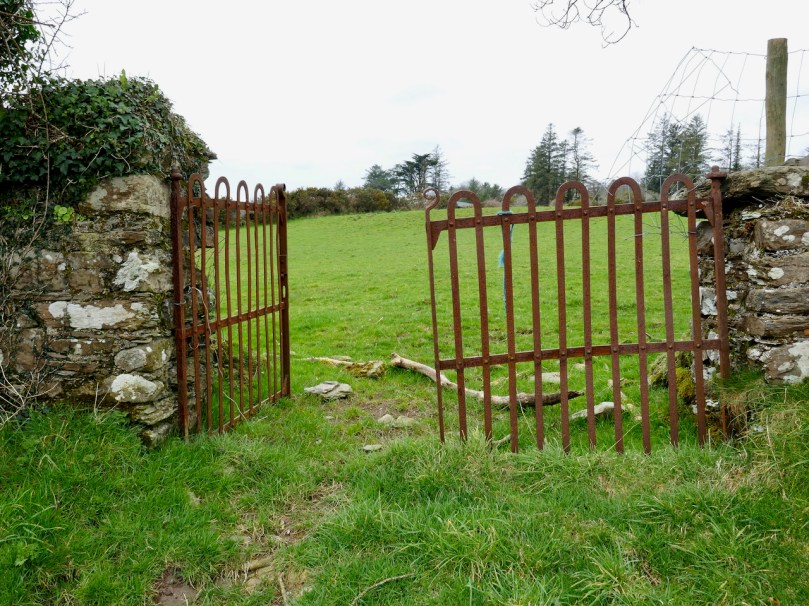
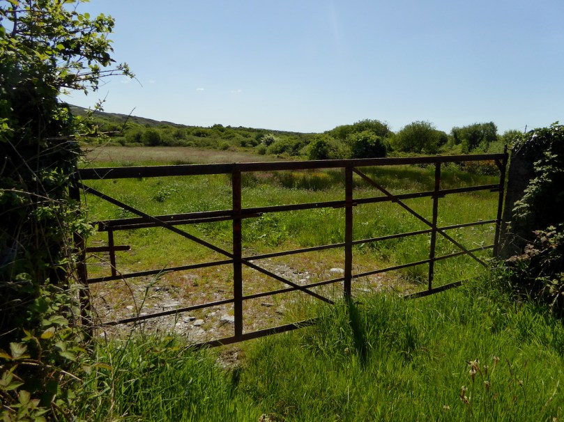
There is no glimpse of it in advance – you arrive at a gate, and there it is – one of the wonders of medieval architecture marooned in a peaceful little field.

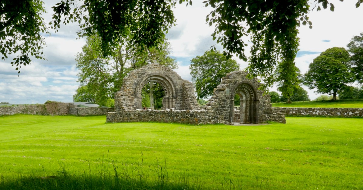
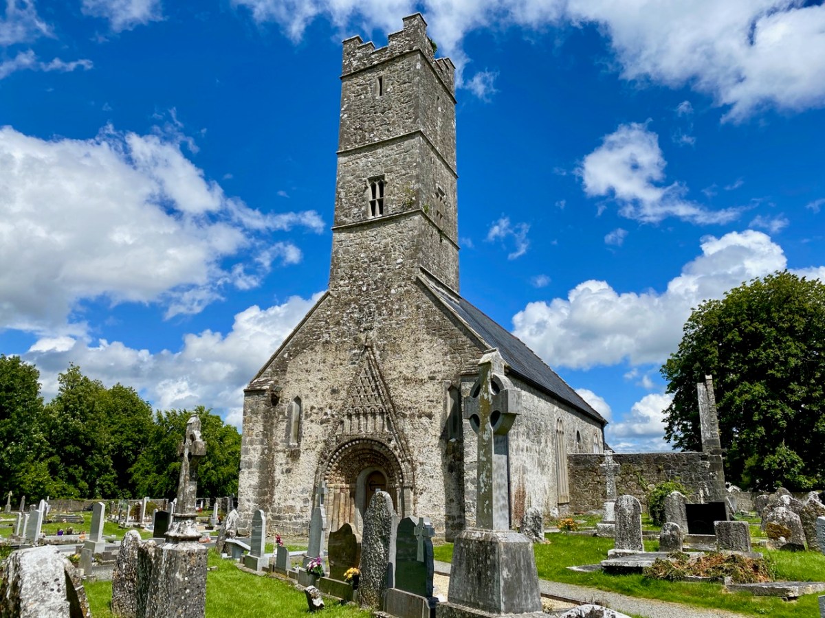
This is a nave-and-chancel church, typical of the time. It is associated with Devorgilla, wife of Tiarnan O’Rourke, as it is said to be the place to which she retired as a penitent, for the sin of absconding with Diarmuid McMurrough and being the unwitting cause of the Norman Invasion. However, there are many sides to this story, and I have just read a most entertaining version, Dervorgilla: scarlet woman or scapegoat?, which claims that she was entirely innocent of the misdeeds she is famous for. Whether she died there, or at Mellifont, as the article asserts, she was certainly responsible for re-building the church in 1167, which places it firmly in the date-range for the full flowering of the Hiberno-Romanesque style.

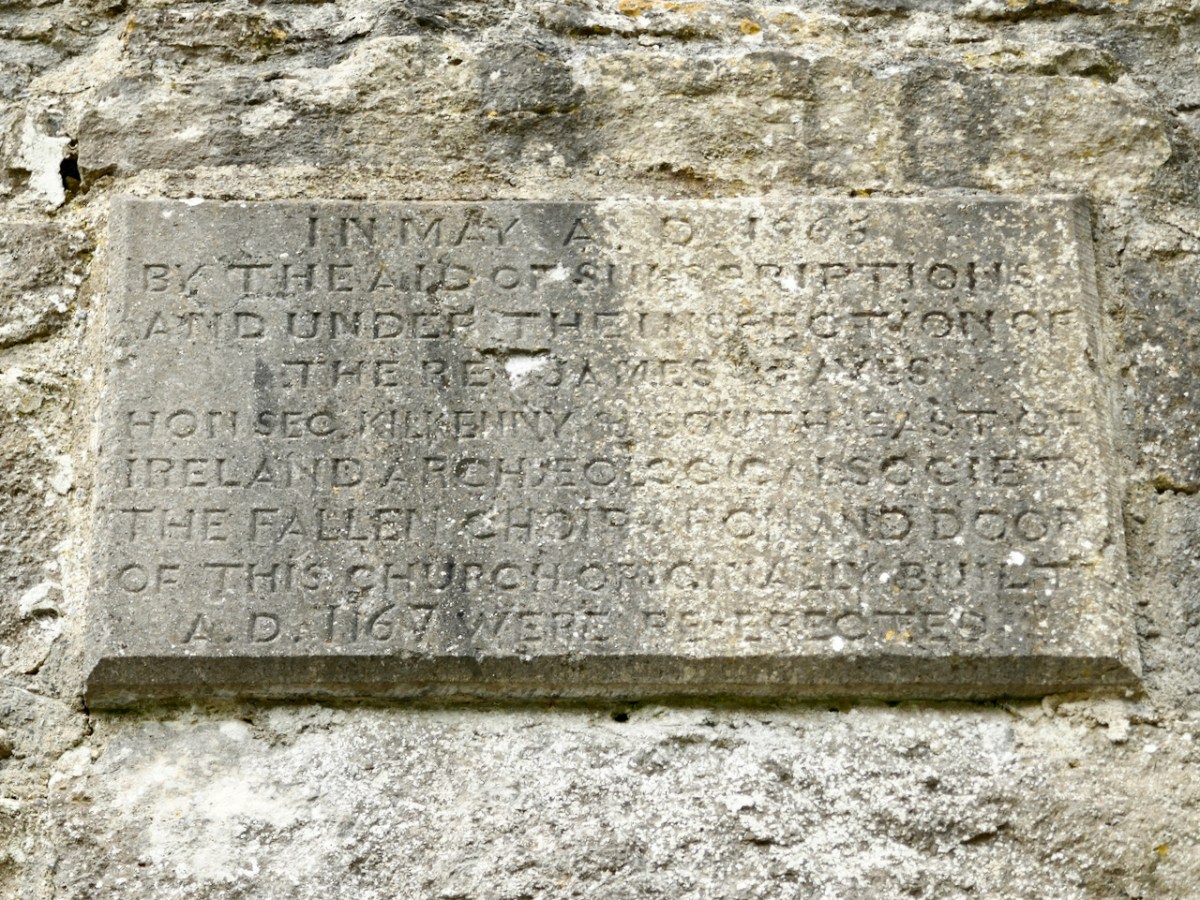
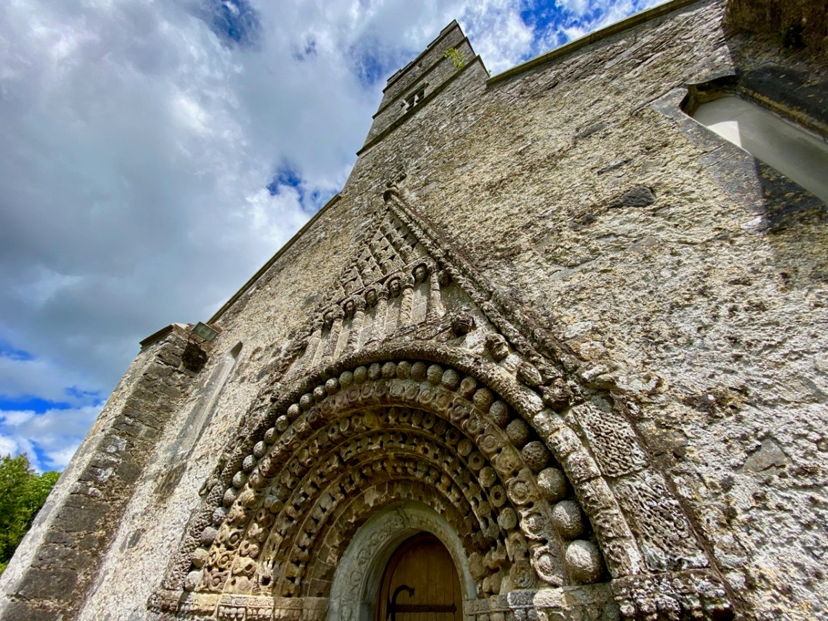
The little church was in ruins by the 1860s and one of the foremost antiquarians of the day, James Graves, of the Kilkenny Antiquarian Society, supervised the reconstruction of the chancel arch, as recorded on a plaque on the inside wall. Our old friend George Victor du Noyer was along to give advice.

By all accounts, they did a careful and informed job of it, digging out the carved stones from the rubble and debris of the collapsed arch and walls, and using a skilled mason to rebuild the arch and doorway. Du Noyer’s drawings* at the time, such as the one above, give an insight into what they found – all the pieces had to be carefully re-assembled, or replaced with ‘blanks’ to indicate what was lost.

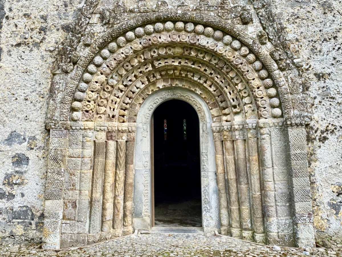
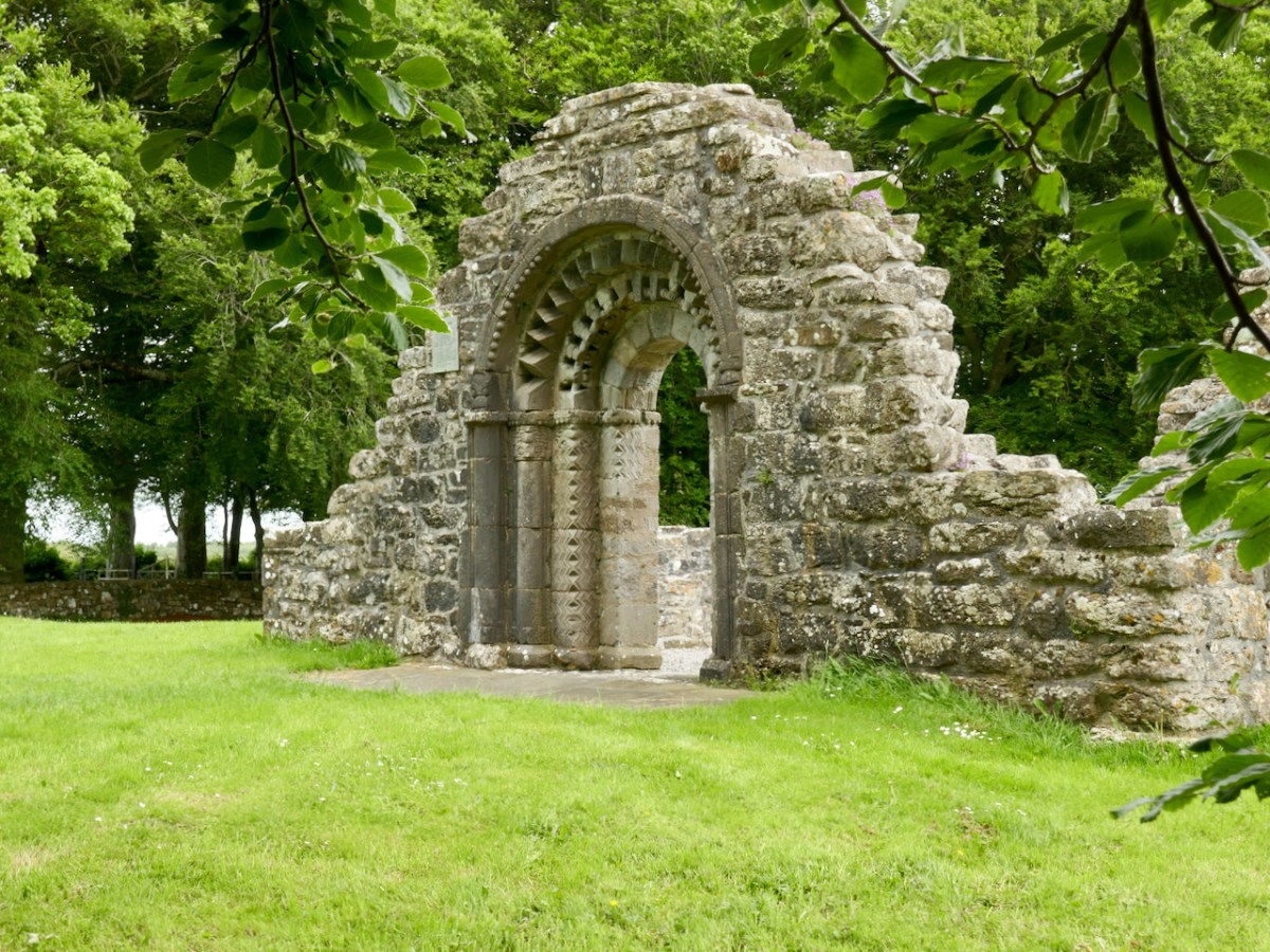
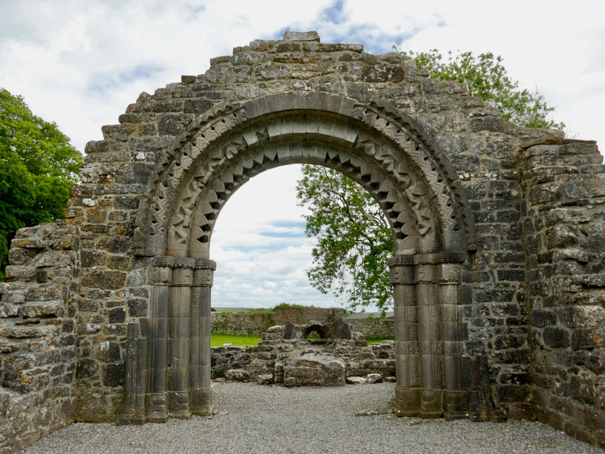
In 1907, Thomas Westropp arrived to admire the skill of the reconstruction job and to make his own observations and drawings. (You’ve met Westropp before too, and may again.) From those drawings, it can be seen that Graves’s reconstruction has lasted intact to the present day. While not quite as accurate as du Noyer’s sketches, Westropp’s drawings are a valuable addition to the literature on this church and capture in particular the spectacular west doorway (above).**

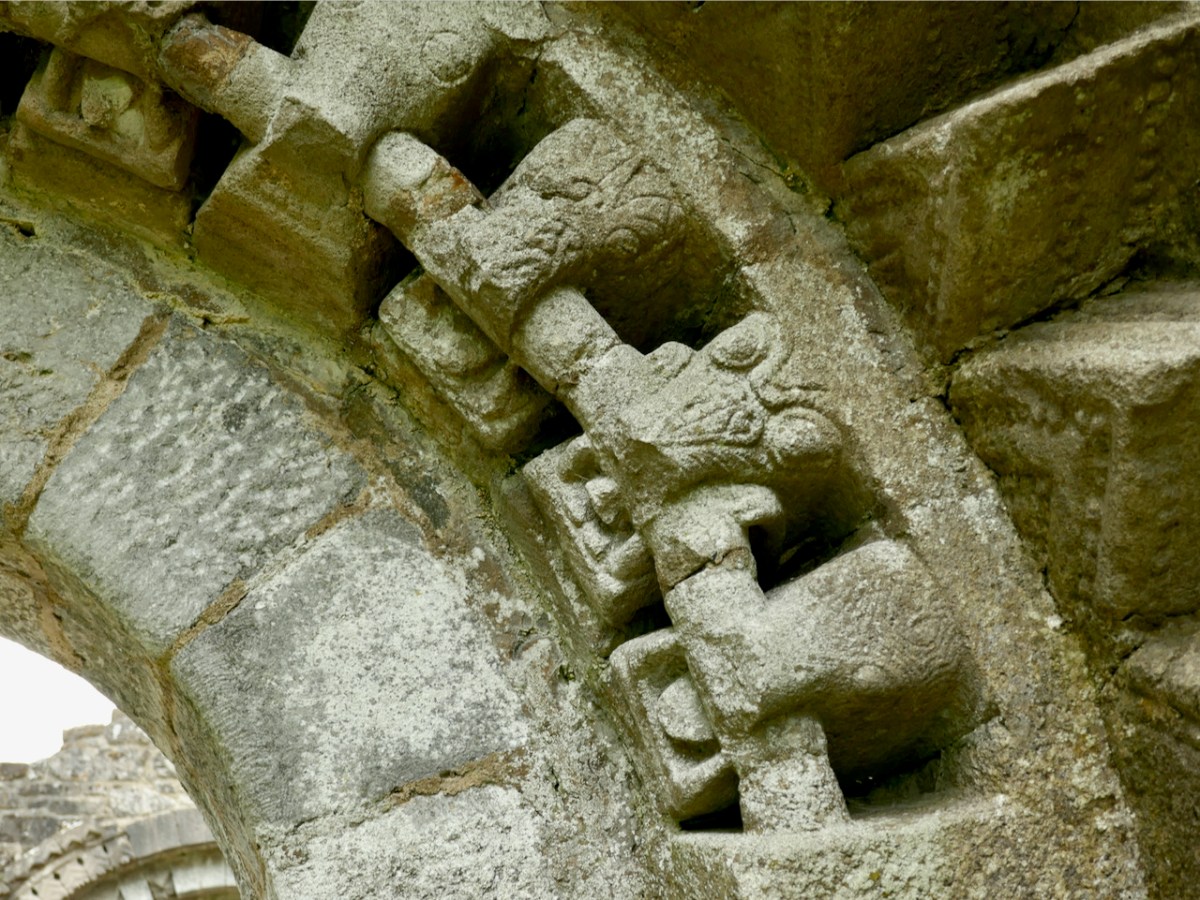
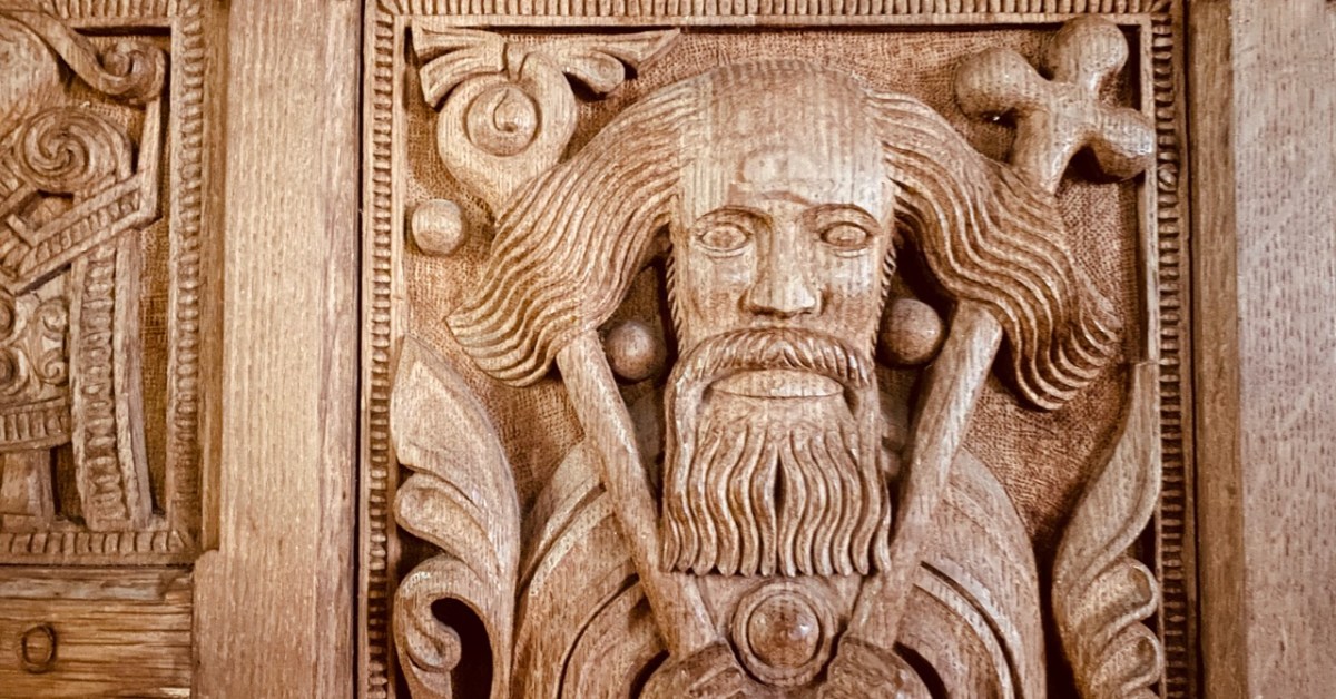
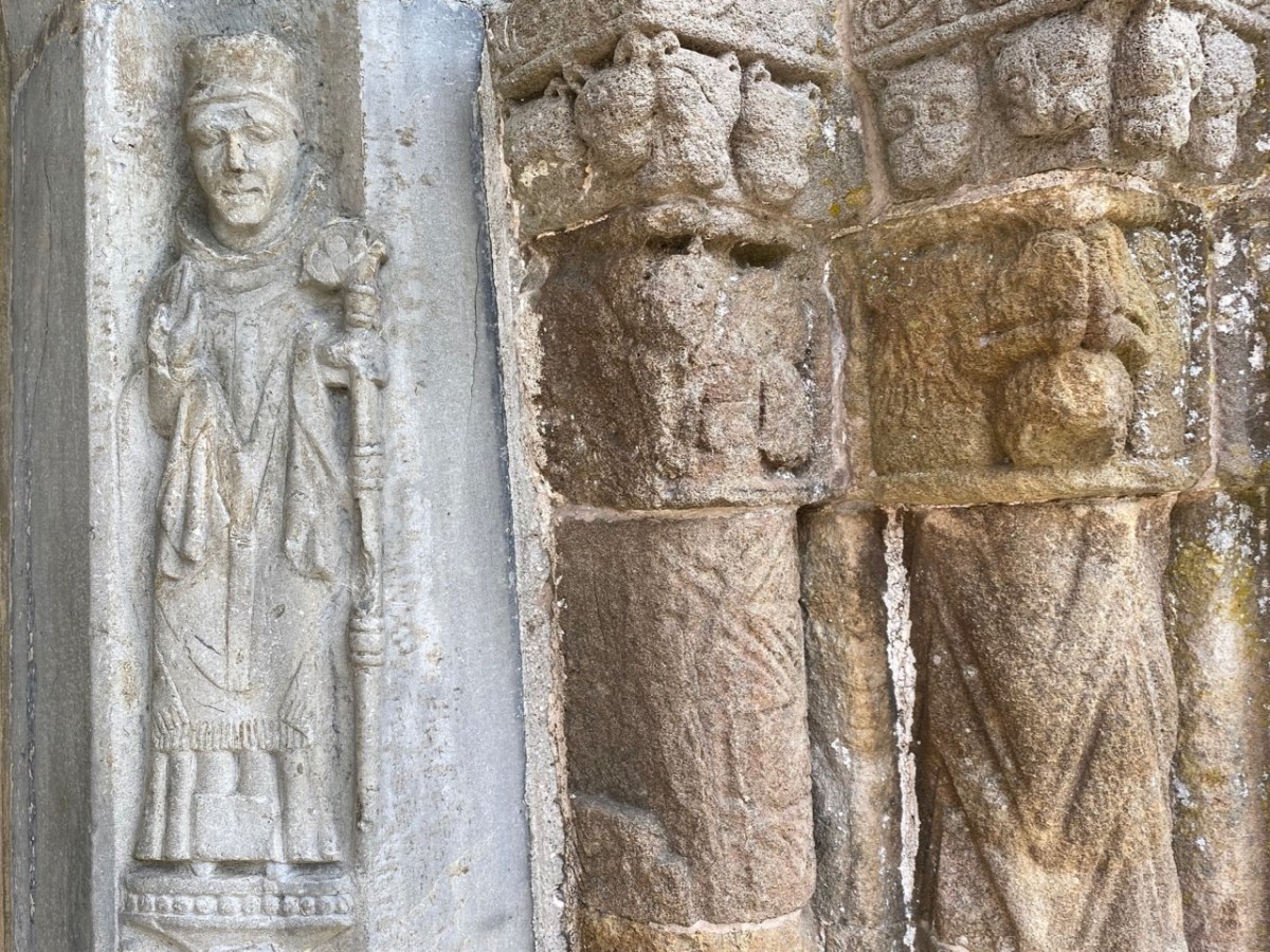
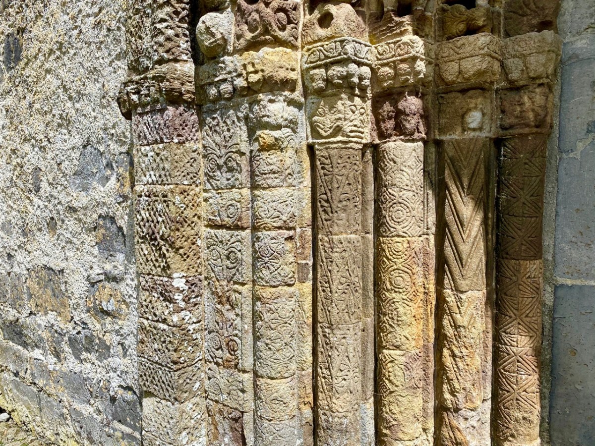
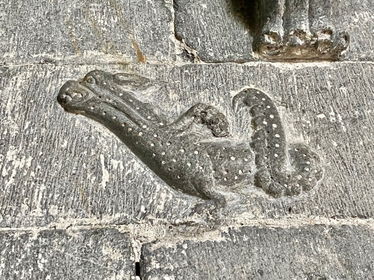
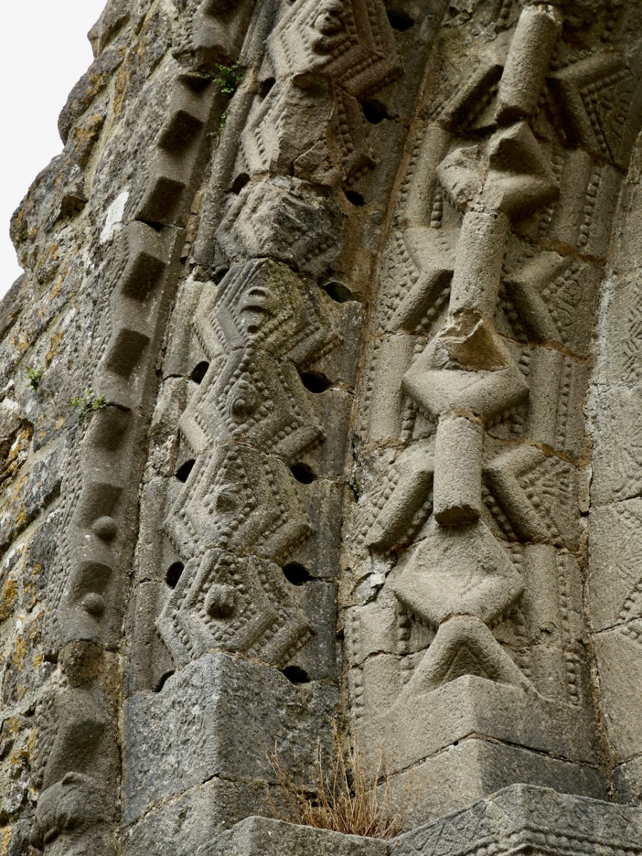
My Romanesque Bible says of the carvings on the Nuns’ Church, The emphasis on low-relief ornament and the use of zoomorphic elements are typical of Irish Romanesque and show the adaptation of English and Continental Romanesque influences to the traditions of Insular art. That’s a fancy way of saying that there are lots of animal motifs here. Most obvious are the voussoirs of beast heads biting on roll moulding that form the arch of the second order of the four orders of the West doorway. 

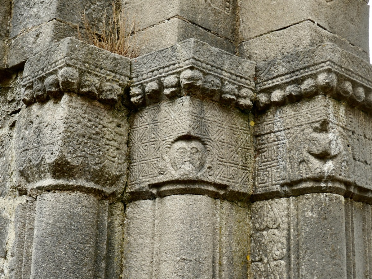
But monster heads and snakes are seen here and there on capitals and jambs, as well as all the usual chevrons, roll mouldings, foliage and interlace patterns. 

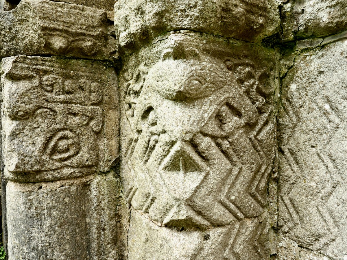
The chancel arch is equally highly carved. Among the intriguing elements are the capitals on the both sides of the arch, which have both human and beast heads, together with geometric ornamentation (such as a Greek key design), rows of cats’ heads, and beading. 

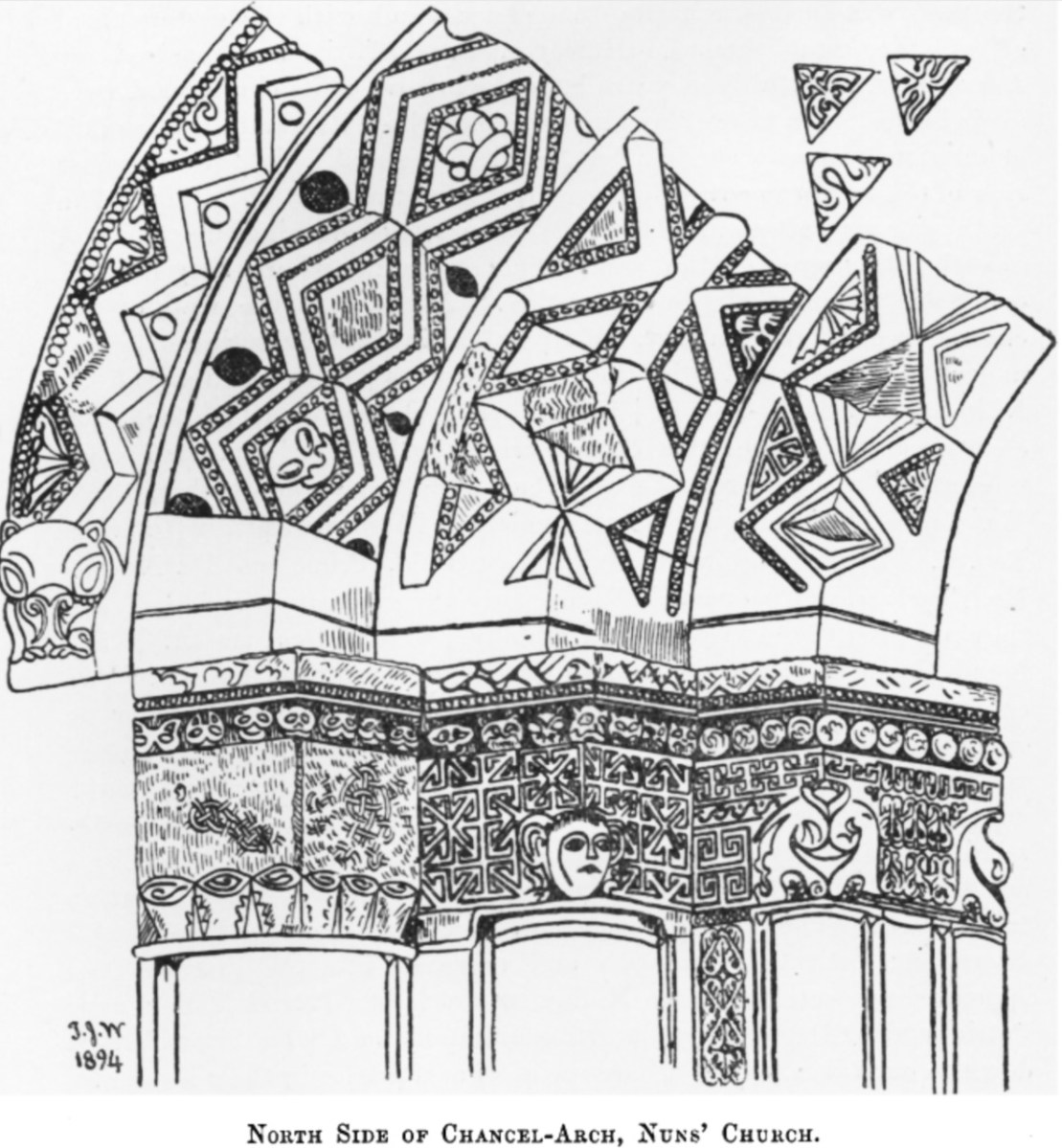
Westropp’s drawing and my photographs above, of the north side of the chancel arch and below, of the south side.

Westropp’s drawing also shows the base or plinth of the jambs, which he says are quite unusual because of both the ‘strange bulbs’ and the ‘discs displaying crosses.’ My photo of what he’s referring to is below.

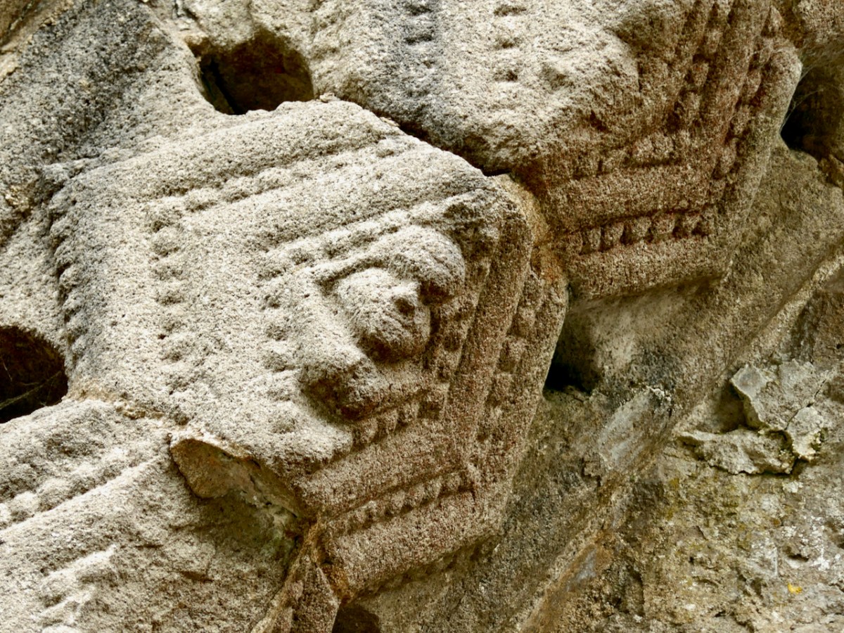
In one of the lozenges formed by the two rows of chevrons, carved point-to-point on the chancel arch, is an exhibitionist figure – a tiny head and legs, with the legs pulled behind the head. Can you see it in the photograph below?

How about this one, below? It’s been interpreted as a sheela-na-gig, a similar exhibitionist genitals-displaying figure, although this one is a lot smaller than a typical sheela. 

Give yourself enough time here to trace the carvings with your eyes – there is so much detail to observe and some of it is easy to miss. 

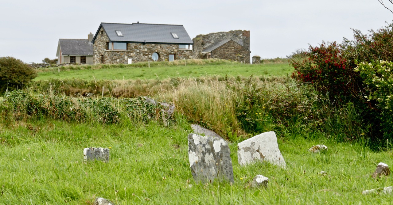
The small field is full of bumps and hollows – evidence that this was once the centre of a convent with substantial buildings around the church, separated, of course, by a ‘decent’ distance from the male monastery, but connected by those causeways.

Many people who visit Clonmacnoise don’t realise that the Nuns’ Church is only a short stroll away and never see this tiny, perfect example of Irish Romanesque architecture. Now – you’ve been let in on the secret!

* Du Noyer drawing courtesy of Europeana.eu
**A Description of the Ancient Buildings and Crosses at Clonmacnois, King’s County, Thomas Johnson Westropp, The Journal of the Royal Society of Antiquaries of Ireland, Fifth Series, Vol. 37, No. 3, 1907, pp. 277-306

Back to Clonfert

Clonfert is only a couple of counties over from us: we just have to skip through a bit of Cork and Tipperary and there we are in Galway – a tiny corner of it that is shaped by the River Shannon. So, on a Thursday afternoon at the beginning of June, we found ourselves tripping along dead straight boreens – narrow for the most part – taking us through lush dairy lands – on a quest to revisit Clonfert’s medieval Cathedral, and its associations with one of Ireland’s most famous saints: Brendan the Navigator.

As we approached the little settlement of Clonfert, our empty road ahead was interrupted by a small white car, which seemed to travel erratically from one side of the lane to the other, and our arrival made little difference to its progress. As we got near, we realised that there was a wiry Jack Russell ambling along the road in front of the car: it was clear that the terrier was having its daily walk, with the owner driving along protectively behind it, regardless of where its fancy might take it. Ah, sure – we were in no hurry, so we joined the procession and waited as the dog sniffed and shuffled its way back home: eventually, dog, car and owner vanished through a gate, and we had the road to ourselves once again . . . This is life in Ireland, and it’s good!

Clonfert’s grandly styled ‘Cathedral’ is so important historically, yet it could hardly be more remotely situated. From the east (upper picture above) it looks like many another Church of Ireland building, maybe not worth a second glance – unless, like us, you can’t resist examining every unturned stone because there is invariably something unexpected to be found under it. Just turn the corner and have a look at the west entrance door:

That doorway, with its exquisite decoration dating probably from the 12th century, has been described as ‘the supreme expression of Romanesque decoration in Ireland’. The carvings, although suffering from hundreds of years of wear and tear from the Irish elements, still display an extraordinary richness and variety: we can only wonder at the inspiration, skill and knowledge of the carver, who must have been deeply immersed in both lore and craft. Tadhg O’Keeffe, current Professor of Archaeology at University College Dublin, suggests a date of c1180 for this doorway. Records state that the church was burnt during a Viking raid in 1179, the same year in which a synod was held there by St Laurence O’Toole; installation of this imposing entrance may be connected with these events. Finola’s post today also explores Romanesque carvings not too far away, at Clonmacnoise. She has also written on Clonfert’s architecture in her Irish Romanesque series.

St Brendan lived from 484 to 577. We saw his birthplace in Fenit, Co Kerry, a few years ago. He founded many monasteries in Ireland but arranged for his body to be taken secretly to Clonfert Cathedral for burial as he didn’t want his remains to be disinterred by relic hunters. His grave is a stone slab just outside the great west door. On it are said to be the marks of cats’ paws – interestingly linked, according to folklore, with the many carvings of cats’ heads on the doorway arches.

When we first visited Clonfert, many years ago, the cathedral itself was closed and we went away with the impression that we had seen all the wonders that the place had to offer by our explorations of the outside of the building and its setting. We were wrong: on this occasion the door was unlocked and there were unexpected treats hidden for us in the interior.

Further carvings decorate the church walls: they vary in date and style, but all are fascinating. Here is a selection – notice the seemingly random arrangement of heads and animal features on the great 15th century chancel arch, above.

Angels, cross-slabs, a wyvern and, astonishingly, this fine mermaid complete with comb and mirror. I have found very little information to identify why these various carvings are found here in the Cathedral, apart from general legends which suggests links with Saint Brendan.

The carved stone head was found ‘in the ceiling’ when restoration work was carried out in 1985. It is said to date from around 1500, while the ancient and beautiful font is attributed to the thirteenth century. We could linger and feast on further treasures inside the church, but we need to look at the surroundings, which reveal yet more history.

This extract from the 25″ OS map – late nineteenth century – shows the cathedral and some of the landscape features associated with it. We came here a few years ago, when we were researching Ireland’s waterways, following in the footsteps of English writer L T C Rolt. In his book ‘Green & Silver’ we read of his admiration for Saint Brendan, and his determination to find the grave at Clonfert, which he did in 1946. His book is illustrated with photographs taken by his wife Angela, and the one picture from Clonfert which is used in the book is this one of the ‘Yew Walk’ which was laid out as part of the gardens of the Bishop’s Palace, which you can see marked on the map.

Our own photo of the Yew Walk at Clonfert was taken a few days ago. You can see that it survives, although neglected today. Some of the yew trees are said to be up to 500 years old. From the map you can also see that the Yew Walk connected the Cathedral to the 16th century ‘Clonfert Palace’, and was set out as an ornamental cruciform route, suggesting the path that might have been taken by the monks a thousand years ago. When we explored previously, we discovered the ruins of the Palace at the end of the Yew Walk, and wondered why it has been left in this state (since 1954, as we subsequently learned). The answer to that is fascinating, and I urge you to read my full account from that first visit, here. Below is a photo dating from c1950, showing the Palace at that time (with thanks to Dr Christy Cunniffe). My own photos from this week’s visit follow.

Clonfert might have been a very different place today if Queen Elizabeth had been listened to:

 . . . We are desirous that a college should be erected in the nature of a university in some convenient place in Irelande, for instruction and education of youth in learning. And we conceive the town of Clonfert within the province of Connaught to be aptlie seated both for helth and comodity of ryver Shenen running by it . . .

Queen Elizabeth, Letter to the Bishop Of Clonfert, 1579

The Queen’s advice was not taken up, and Trinity College Dublin was established instead – in 1592 – becoming Ireland’s first University.

The site at Clonfert is so interesting – and covers so many periods in Ireland’s history – right up to the 20th century. It was well worth revisiting – and will merit further visits in the future, too. I’ll leave you with one aspect that probably impressed us most this time around. It’s the Bishop’s Throne which is hidden in the shadows of the Cathedral chancel. Carved from oak, most likely in the 19th century, it is a wonderful representation of Saint Brendan himself, surrounded by the Four Evangelists, crafted in the style of the Book of Kells. Look at him, also, on the header. Here is the Irish saint who set sail out on a voyage into the unknown – seeking Paradise – and discovered the World!

Another Gate Post (Vernacular Gates of West Cork 2)

The hand-forged wrought iron farm gate, featured in last week’s post, was once ubiquitous around West Cork, mostly made by local blacksmiths. Perhaps enterprising blacksmiths also mass-produced gates, which were then sold by local shops. In Ballydehob, for example, around 1890, Wolfe’s shop was selling this gate, captured by the photographer Robert French and now part of the Lawrence Collection at the National Library of Ireland (used with their permission).

To understand the technology and skill that went into making and repairing these gates, take a look at this video, the follow-on to last week’s, from Shem Caulfield in Kilkenny. (If you haven’t already seen Part 1, check back on it now for diagrams of what I will be talking about.)

Forge-welding, as illustrated in the video, can be seen in this gate (below), located on the Twelve Arch Bridge in Ballydehob, separating the bridge from what was once the railway station. [Or so I thought – read on to see how mistaken I was.]

The hooped strengthening bars are a very common element in West Cork vernacular gates, but in this case, you can clearly see that the loops have been added by forge-welding. The other thing about this gate is the perfection and uniformity of the twists – a very skilful job indeed. And not a rivet in sight – each joint appears to be forge-welded. [EDIT: I got this SO wrong. This is not an example of forge welding, but “a dodgy repair job with an arc welder” – thanks to Pat O’Driscoll for putting me straight. I think we can take it this is NOT a hand-forged gate but a more recent example – machine made, given the perfection of the twists. I am adding this clarification rather than deleting the photograph and text to show that we are all still learning!]

A more common, and perhaps more traditional approach was to make these looped strengthening bars by bending one continuous length of iron and attaching them to the cross bars with rivets. This beautiful gate (above), still in situ in Ballybane, near Ballydehob, illustrates this.

In this photograph you can see that the cross bars are joined to the slapping stile with a mortice and tenon joint. In the forge the stile is heated until a hole can be punched through it. The end of the bar is inserted into this hole and then hammered flat to fix it in place.

Using the same mortice and tenon technique, a heel is affixed to the top (and sometimes the bottom bar) to further strengthen and hang the gate and prevent sagging. Across the road from this gate is an identical one (below) where only half the original gate remains – how wonderful that it is still kept in place!

Entrance gates performed a different function than a farm or field gate. The height of a field gate accommodated the head of a horse or a cow to look over it. Entrance gates, understandably, were often made to deter anyone from going over them. They were taller and certainly less inviting to a climber. I spotted this lovely red set in Rossmore – you can see all the traits of the hand-forged gate in them.

But entrance gates were also designed to make a more prestigious statement about the people going through them or the house behind them. This beautiful set of gates (below) is on the road up to Brow Head and is definitely made to impress. My favourite part is that there is a discrete pedestrian gate built in to them.

Finally, a couple of garden gates – perfect for leaning across for the chat with the neighbours. This one is next door to me, rescued and re-purposed by my friend Hildegard. I love the way the stiles have been split – such a simple way to create a decorative element.

And how about this one, spotted at Coolkelure? A few simple twists and a couple of scrolls and you’ve got a pretty little gate that will last forever.

Over the course of the twentieth century hand-forged entrance gates gave way to cast-iron gates made in foundries and eventually to mass-produced and imported varieties, bought from a catalogue. Meanwhile, farmers bought the tubular steel gates that are everywhere around us. When you see those gates, remember that they have probably replaced a hand-forged example of the blacksmith’s skill, such as the ones in Brian Lalor’s engraving below, which conjures up for me such a feeling for a lost tradition.

© Brian Lalor, used with permission

A Gate Post (Vernacular Gates of West Cork)

If you look closely, all around the Irish countryside are still scattered old wrought iron gates made by local blacksmiths. These gates, according to Shem Caulfied, “are particular to Ireland. . .  and their design often illustrates a distinctive local style. This local or vernacular style is an important element of our rural heritage.” Shem has produced lovely videos for the Kilkenny Co Council on forged gates – see the first one here as a good introduction to these gates.

I’ve been looking out for farm gates to see if I can identify a local style. So far I haven’t found any of the hooped braces which are the dominant kind in some parts. This illustration (and the others in this post) is from an article in a 1974 Ireland of the Welcomes by Gerald Tyler, designer and architectural historian, who worked with the Kilkenny Design Workshop. The article has given me the vocabulary and some of the knowledge I need to look at these gates. By the way, the gate was assembled ‘out of square’ so that as it naturally sagged it would come into square.

Local blacksmiths around this part of West Cork kept the design straightforward and sturdy. Some gates had no bracing at all. The one below is the simplest of all types – three upright stiles and five bars. The stile on the left is the hanging stile and the one on the right, where the latch is, is the ‘slapping’ stile.

But most gates had diagonal braces of one kind or another. Here are a few local examples.

Above is the only example I have seen with parallel diagonal braces.

This gate has an X brace, but an additional half stile was also inserted at some point.

A favourite way to brace was a pair of up-pointing diagonals. This gate is barely hanging in. The spikes on top may have been to deter cattle or horses from leaning over the top bar, or maybe small boys from climbing.

The diagonals could be down-pointing, as in the example above, which is actually a double gate. This gate is made of band iron which was often used (or straightened and re-used from old wheels). In cross section, it’s flat on one side and curved on the other, making it easily recognisable. The curved side was the one in contact with the road when it was used on wheels. Many of our local gates are band iron, or a combination of straight iron and band iron.

Gates often had to be widened to allow for modern machinery.  The gate above and the one in the illustration have been widened by the insertion of extra lengths of iron in the horizontal bars. Often this is so skilfully done that it’s imperceptible.

This gate has been widened by the addition of a new section on the slapping side.

This double gate, which has no cross-bracing, only vertical stiles, has been widened by adding a section in the middle, attached to the left hand side. Did the farmer regret having no easy way to just hop over the gate and take the opportunity to put in a set of steps?

The gate in my lead photograph features mainly half stiles, but was once a lot fancier than it is now. The gate above has both full-height stiles and a diagonal brace and has been paired with a newer steel gate – you see this a lot around here.

Some gates had extra horizontal bars at the bottom to prevent small animals (calves or sheep) from squirming through the openings. Above is a lovely example from a local farmyard.

I have been amazed, and cheered, to see how many wrought iron gates are still to be found around here, although sometimes you have to poke around a bit to find them, as in the example above. . However, they are disappearing, and the vast majority have been replaced by the ubiquitous tubular steel gates. I am planning a further post to explore some of the skills of the blacksmiths to be seen in the details of our local gates. Meanwhile, take a look at how Pat O’Driscoll still works in the time-honoured way in his forge, now located in Durrus.

A Signal Success in Irish Engineering – Part 7: Cloghane, Mizen Head

It’s a long way from West Cork, Ireland, to Sydney, Australia! And I’m not suggesting that signals could travel that far in the early 19th century . . . But I couldn’t resist putting up this engraving when I found it while researching signal towers generally as it is in fact an exemplary view with which to head up this – the seventh of our explorations into a fascinating subject. It has everything: the signal station itself, built on a prominent headland with a lighthouse nearby; a ‘telegraph’ mast and a flag mast for signalling; a man with a telescope looking out for a signal coming in – and a pile of logs with which to make a beacon fire to communicate urgently at night! The only difference, in fact, between the Irish stations and this ‘colonial’ one on the other side of the world is the building material. In Terra Australis (the name used for that continent until 1824, and meaning ‘southern land’) it was timber, whereas in Ireland the towers were of masonry and constructed with elements resembling medieval tower houses.

But it’s fair to say that today’s foray into the story of the Irish Napoleonic-era signal towers also has everything. Perched on Ireland’s most southwesterly point – Mizen Head in the townland of Cloghane – this site is one part of a craggy, indented promontory which is scattered with historical elements.

I have tried to illustrate a history time-line graphically by superimposing some of the significant sites on an aerial view (above – courtesy of mizenhead.ie), although even this does not tell the full story. Apart from an undated promontory fort in the north of the townland the signal towers are the earliest elements, specifically dating from 1804 and part of the network of 81 towers around the whole coast of Ireland which we have been charting in our posts. Interestingly, the two towers shown on the top of this view – at Cloghane and Brow Head – are the closest together of any around the coast, being only 3.8 km apart. The average distance between towers is 13.5 km, while the maximum distance is 36.9 km (between Ballydavid and Kerry Head in Co Kerry): we have not yet explored those sites. Here are two views from Cloghane across to the signal tower at Brow Head:

A feature at Cloghane which doesn’t show up on the aerial view is this Second World War lookout post, built close to the early signal tower around 1942. 83 of these structures were built by the Irish Defence Force to monitor activity at sea, many of them relating to Napoleonic-era sites for obvious reasons: these locations had already been selected for their inter-visibility and the panoramic views which they commanded. We have encountered these ‘Emergency-era’ posts previously at Kedge Point, Baltimore, and Ballyroon Mountain, Sheep’s Head (see the full list of links at the end of this post). We shouldn’t get diverted, but if you want to know more about these here is an excellent creative presentation on them carried out in 2014 by Tim Schmelzer of Vienna – particularly, I recommend that you view the first of the videos: it’s wonderful! The LOPs were designed by Howard Cooke RIBA of the Irish Office of Public Works in 1939 and I was fascinated to see that the design achieved recognition (‘posthumously’) from the National Inventory of Ireland Buildings Archive. The posts were cramped, damp and minimal, but apparently at least equipped with small fireplaces:

Mizen Head has drama: there is no land beyond this place until you reach America. And, if you are approaching Ireland from the south or west, Cloghane will be your first landfall. But it’s a dangerous coastline, particularly in stormy weather or at times of poor visibility. Hardly surprising, then, that a fog signal station was established on the furthest point in the early 20th century, under the jurisdiction of the Fastnet Rock Lighthouse. This was initially only a foghorn, powered by explosives: a light was not placed there until 1959.

That this signal tower is the virtually identical ‘twin’ of the one we explored at Robert’s Head must be significant, as both are unlike the general pattern we have seen elsewhere: a simple ‘defensible’ structure some 6m square with flat roof, parapets, machicolations and bartizans. My conclusion at Robert’s Head was that the tower had been substantially rebuilt to incorporate upgraded accommodation, perhaps for use by the Coast Guard which was formally established in 1822. Comparing it now with the Cloghane structure it seems more likely that these might both have originated as larger, better appointed buildings. I wonder if this could be because of the relative remoteness of both sites, which would not be easy to populate and service from any nearby community. It was a long trek to Cloghane: the original dedicated trackway, some 2.7 km long is still defined on the landscape, and passes under the 232m high Mizen Peak.

The signal tower at Cloghane is in reasonable condition considering its age and the long period of abandonment (many of the towers went out of use after 1812 although some – possibly including this one – were revived and adapted for use by the Coast Guard). Many visitors have left their marks over the years, and some of the graffiti is intriguing! There is also some vestige of the timber casement frame remaining in one of the window openings: surprising considering the level of exposure to severe storms at this remote site.


There’s a conundrum at this site that I want to share with you. A little distance to the south of the signal station building is a grouping of stones which are easy to miss at first glance, Have a closer look:

It’s the base of a circular building, or enclosure – a few metres in diameter. Archaeologists amongst you might think in terms of round towers but we can discount that in this desolate location. It does not seem to relate to the signal station buildings, either in terms of architecture (it gives the impression of being rougher and, perhaps, earlier) or usage. With regard to its age, it shows up as a feature on the early 6″ Ordnance Survey map:

What might it be? A mine chimney? But the Mizen Head Copper Mine was a long way from here (refer to the annotated aerial view). The size and shape resemble a gunpowder magazine which we came across at Dhurode Mine, on the north side of the peninsula. The only reason for having a gunpowder store at a signal station would be for a fog signal operated by explosives, as was the case at the Fog Signal Station lower down the Head, built in the early twentieth century. This is clearly much earlier. The dreamer in me pictures, rather, a hut lived in by a medieval hermit, supported by a local monastic settlement to keep beacons burning on Ireland’s headlands in perpetuity. Like the round towers, these were signals to travellers in ancient times that here might be found a haven. For seafarers, perhaps, this one signalled the gateway to a fertile land of enlightenment.

The previous posts in this series can be found through these links:

Part 1: Kedge Point, Co Cork

Part 2: Ballyroon Mountain, Co Cork

Part 3: Old Head of Kinsale, Co Cork

Part 4: Robert’s Head, Co Cork

Part 5: Downeen, Co Cork

Part 6: Dunnycove

A Signal Success in Irish Engineering – Part 6: Dunnycove

Galley Head, in West Cork, is one of those wild and exposed headlands where you get exceptional views in all directions. In our hunt for Napoleonic-era signal towers on the Irish coast you would fully expect to find one of the towers here – but no! A lighthouse and lightkeepers’ cottages – yes. These date from around 1875 but, in the early years of the nineteenth century, the strategically important signal tower was built inland, in the nearby townland of Dunnycove.

The header picture shows what remains of the tower itself today. This has in fact been adapted over the years, and the original building conformed to the square tower pattern that we have investigated elsewhere (a good example is at the old Head of Kinsale). The upper picture (above) shows the lighthouse at Galley Head seen from high ground to the east, while the lower picture is an aerial view of the Dunnycove signal tower site in its wider surroundings. Below is an 1806 map of the ‘. . . Ground occupied by the Signal Tower and Road leading to it at Galley Head . . .’ This tower is often referred to as the Galley Head Tower, even though it is some distance inland from the Head. But it is well placed to command views to the towers in the communication chain immediately to the west (Glandore) and east (Seven Heads).

The curious profile of the site as marked out on this early map shows a segmental shaped area to the south of the tower. It is likely that this was where the signal mast itself was situated. I am intrigued by the descriptions of the surrounding land: ‘good Meadow’, ‘Indifferent Pasture’, ‘Very Good Pasture Ground’ and ‘Arable good Ground’. Also, on the left of the survey drawing appears to be a table of land values, and the statement that ‘The Road is already made to this Tower and has very good ditches on each side of it, and is 312 perches long’. The road is in good condition today, as the site has been developed with a cottage and modern studio:

There’s nothing better than good local knowledge when you are trying to piece together a historic jigsaw puzzle. We were delighted to run into Billy Sheehan working in his neighbouring garden: it didn’t take long to establish that his own family had been involved in the signal tower site for generations, and had been connected to the local Coast Guard which had used the tower as a lookout point after the original building had fallen into disuse. Here’s Billy and myself, below. Under us is an extract from the 25″ Ordnance Survey map, drawn between 1888 and 1913. Note how on this map the signal tower site itself has changed since 1806, with many more buildings, a ‘flagstaff’ and a ‘semaphore’ indicated. These all undoubtedly date from the Coast Guard use of the site – you can also see the Coast Guard Station indicated below the tower: there are just a few masonry pillars left at that location today.

This is the ramp leading down to the water at Ballycusheen Strand, not far from Dunnycove. The pig is a well-known local landmark! I was interested to see the reference to ‘semaphore’ on the OS map, outside the original signal tower enclosure. This word recurs frequently in discussions about signal towers. Theoretically, any visual signalling system is an ‘optical semaphore’, but the term is likely to be more specific here and probably refers to an updated mechanical system rather than the ‘flag and ball’ method generally used in the early 19th century, when the signal stations were run by sailors or retired naval men who were well used to reading flag signals through high quality telescopes. There’s a volume to be written on how long-distance signalling evolved over many centuries – not just in Ireland but across Europe and beyond, beginning, perhaps, with The Scottish Parliament passing an Act in 1455 that said:

One bale, or faggot, shall be warning of the approach of the English. Two bales that they were actually coming and four bales, blazing side by side, shall note that the enemy is in great force.

There is a record of Robert Hooke, ‘curator of experiments’ at the Royal Society, proposing a system that combined a telescope and signalling in 1684. One of the important names that surfaces here in Ireland is Richard Lovell Edgeworth (1744 – 1817).  An inventor and writer, Edgeworth was the son of an Anglo-Irish landlord whose family gave their name to the town of Edgeworthstown, Co Longford; he studied at Trinity College, Dublin. In 1767 he placed a bet with his friend, the horse racing gambler Lord March, that he could transmit knowledge of the outcome of a race in just one hour. Using a network of signalling sections erected on high ground, the signal would be observed from one station to the next by means of a telescope. The signal itself consisted of a large pointer that could be placed into eight possible positions in 45 degree increments. A series of two such signals gave a total 64 code elements and a third signal took it up to 512.

Edgeworth (perhaps best known for fathering the writer Maria Edgeworth (1768 – 1849) – one of his 22 children) termed his device a ‘Tellograph’. In November 1794 the most impressive demonstration of his invention used 30-foot-high Tellographs to communicate between Donaghadee, Ireland and Port Patrick, Scotland (about 40 miles). In France at the same time the Chappe brothers succeeded in covering that country with a network of 556 stations stretching a total distance of 4,800 kilometres (3,000 miles). Le système Chappe was used for military and national communications until the 1850s.

Le système Chappe (above). French technology is demonstrated in the 1790s – the very time the First French Republic was threatening the least defensible part of the British Isles – Ireland – and emphasised by the attempts of Wolfe Tone to land a French fleet in Bantry Bay in December 1796. That landing was a failure – due to atrocious weather – but it did, perhaps, wake the British authorities to the wisdom of guarding the Irish coastline. The signal tower system was a hastily devised result of this.

There’s a lot going on at the Dunnycove Signal Station site: the setting remains clearly laid out based on the 1806 plan, and the dominating view is due south. Parts of the original building remain although much has been altered including an external staircase and the surrounding structures.

The upper picture shows a distant view towards the signal station complex: it is on the highest point in the immediate landscape. Next is the view from the present top of the old tower, looking across the segment-shaped land which once held the signal mast and – later – the ‘semaphore’, most likely used to communicate with the Coast Guards below: beyond is the ocean. In 1837 Lewis’s Topographical Dictionary of Ireland had this to say about the area:

. . . In the R C divisions this parish is the head of a union or district, comprising the parishes of Ardfield and Rathbarry, in each of which is a chapel; that of Ardfield is a low, plain, but commodious edifice, situated on the commons. There are schools in which 140 boys and 170 girls are taught, also a school at Dunny Cove, a Sunday school under the superintendence of the vicar, and one or two hedge schools. The ruins of the old church are situated on the highest point of land in the parish; and near them is a building which during the war was used as a signal tower, but is now the residence of Lieut. Speck, who commands the coast-guard at Dunny Cove. Close to the Cove are the ruins of a castle . . .

It seems to me that this site, in particular, has so many stories to tell us. Not just about the one period in history that caused the building of the original tower, but also about how a community has developed and adapted around that building. After the close of the Napoleonic era, when the threat of invasion receded, the tower retained its significance as a high place from which observations can be made. The Water Guard (which became the Coast Guard) took it over and it has remained a dwelling place for families ever since. Billy Sheehan is testament to this ‘living’ history, and the old stonework survives to tell where meals were cooked – where sleeping, waking and working became the rhythm of life for generations on this West Cork hilltop.

Please note that Dunnycove Signal Station is a private property and permission to access it must be sought from the owner

The previous posts in this series can be found through these links:

Part 1: Kedge Point, Co Cork

Part 2: Ballyroon Mountain, Co Cork

Part 3: Old Head of Kinsale, Co Cork

Part 4: Robert’s Head, Co Cork

Part 5: Downeen, Co Cork