An Irish Shakespeare?

rea druid

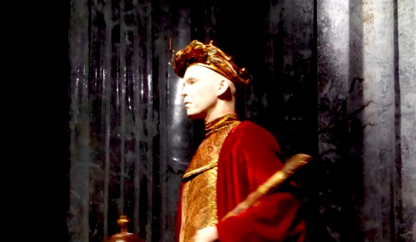
Marty Rea giving a stunning performance in Skibbereen as Richard II in Druid Theatre Company’s tour of Shakespeare’s ‘History Plays’

This week we commemorate the 400th anniversary of Shakespeare’s death which occurred on his birthday, 23rd April, in 1616. He was 52. At least, that’s the received wisdom. It’s quite convenient that the two most important events in his life have the same date – we only have the one to remember – and it’s very apposite that this date should also be St George’s Day: St George is thought of as patron saint of England, and Shakespeare is thought of as the greatest writer in the English language – and partly responsible for the flowering of the Elizabethan Age of Enlightenment.

elizabeth

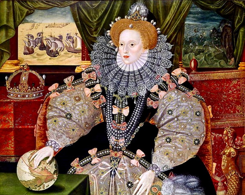
Queen of England and Ireland – the ‘Armada Portrait’ 1588. This painting of Elizabeth I, sometimes attributed to George Gower, is full of symbolism which Shakespeare would have recognised: pearls imply purity, the pomegranate prosperity, the mermaid  ‘the potential destructive nature of females’, and the ruff is shown as a sun halo to depict the ‘Sun Queen’. The paintings show the power of the Navy and its defeat of the Spanish Armada

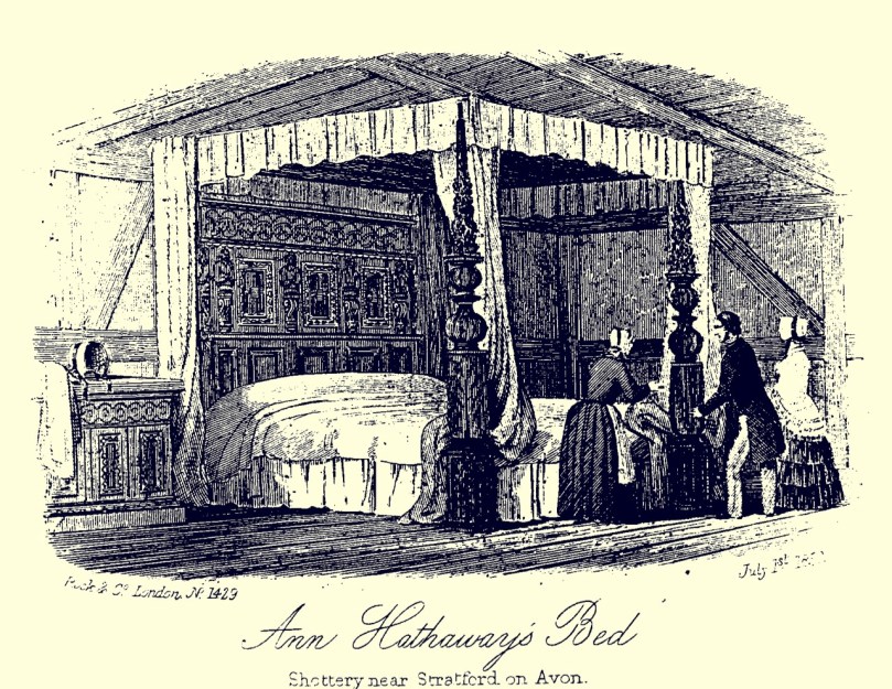
But isn’t all this a little too convenient? If we believe the history books Shakespeare was a simple soul who was born in rural Warwickshire, the son of a glover who had fallen on hard times. Shakespeare attended the local grammar school, where he would have had a limited classical education. At 18 he married Anne Hathaway, 8 years his senior, and their daughter Susanna was born shortly afterwards. Then he disappeared from the records, re-emerging in London in 1592 where he was described in a pamphlet by Robert Greene as an ‘upstart crow’ flapping his poetic wings. Thereafter he was known as an actor, playwright and theatre promoter, returning to his birthplace to retire and leaving us with the legacy of 38 plays and 154 sonnets. His will bequeathed his ‘second best bed’ to his wife and his estate to his children.

second best bed

Was William Shakespeare a real person? Probably – there are quite a few records of his professional life: but the rumour mill is full of suggestions that he was not the author of his plays! As Ireland is a renowned land of poets and bards, I felt sure that, somewhere, I would find a notion that this particular ‘bard’ had Irish connections… I was right!

meath chronicle

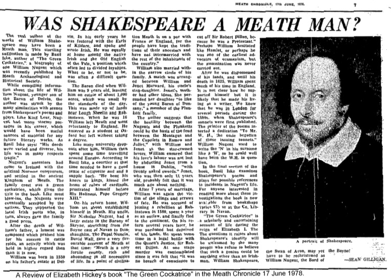
Elizabeth Hickey (1917 – 1999) was a well-known Meath historian and author who lived at Skryne Castle near Tara. Her most famous work is The Green Cockatrice, originally published in 1978 under the pseudonym Basil Iske. In this she traces the career of William Nugent, Baron of Skryne, who lived from 1550 to 1625. According to Hickey Nugent is a very likely candidate for the authorship of Shakespeare’s plays as he ‘…led a life which gave him insights into the kind of political, religious, military, legal and international diplomatic intrigues that populate Shakespeare’s works. For example, he was imprisoned by the state for opposing the cess in Ireland in the 1570s, and he rebelled in 1581, losing a number of supporters to the hangman’s noose and causing him to flee into exile, first into Scotland, then France and Italy – locations which are prominent in Shakespeare’s works. During his exile he met most of the great European leaders, including the Pope, the kings of Spain, France and Scotland, and was involved in Europe-wide planning for an invasion of England…’

Other scholars have suggested that the language use by Shakespeare is, at times, more akin to the English spoken in Ireland in Elizabethan times. One quotes Shakespeare’s character Puck as deriving from the Irish Púca, although the name is also said to have an old English origin. Similarly, Queen Mab  (fairy queen in Romeo and Juliet) is said to derive from Queen Maeve, spelt in Old Irish script as ‘Mab’.

1920px-Joseph_Noel_Paton_-_Puck_and_Fairies,_from_-A_Midsummer_Night's_Dream-_-_Google_Art_Project

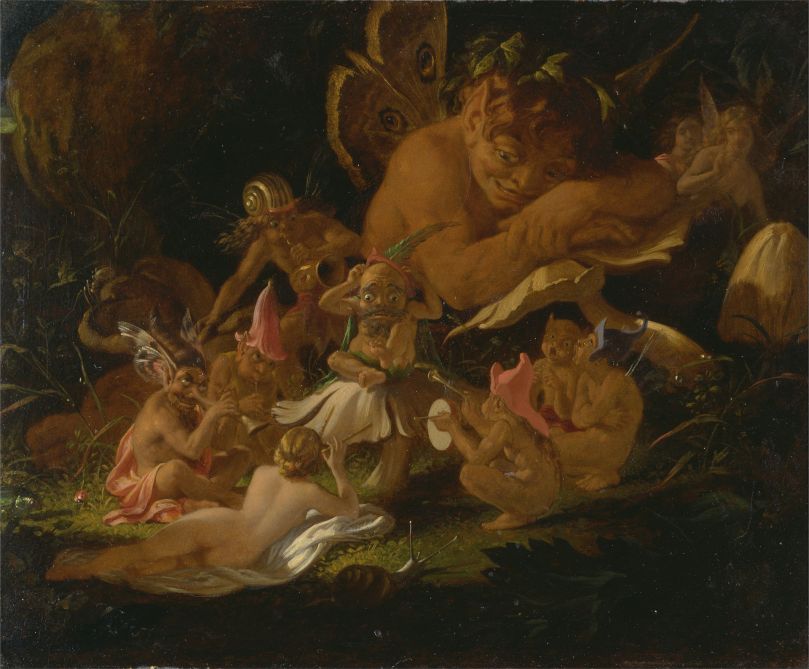
Puck and Fairies, from A Midsummer Night’s Dream, Joseph Noel Paton, c1850

I was intrigued to come across a tradition that Shakespeare composed Hamlet while visiting his friend John Dowland at Dalkey near Dublin, and that the account of the shore of Elsinore is actually based on Coliemore Harbour in Dalkey. There is even a house called ‘Elsinore’ in Dalkey: it dates from 1840. There is also in Dalkey a mosaic plaque to Dowland designed by Sarah Purser.

Coliemore
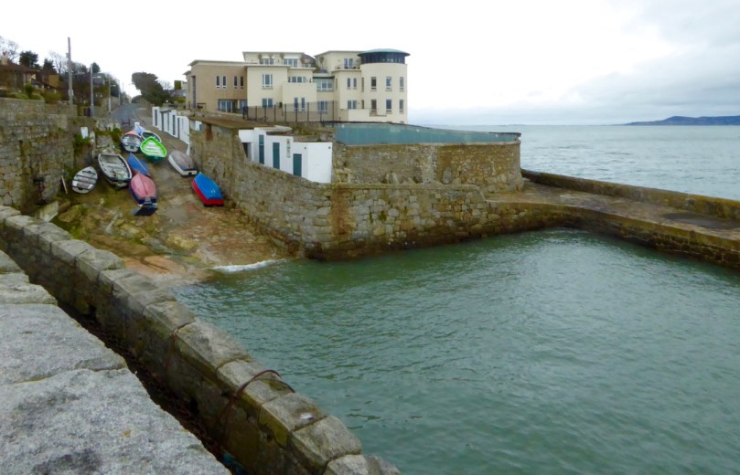
Coliemore Harbour in Dalkey – does it look like Elsinore?

If you have an hour or so to spare you might have a go at reading Shakespeare was Irish – I kid you not… in Indymedia Ireland – it’s tongue in cheek but very comprehensive. Tempting though it is to pursue the idea that the man himself might have been Irish, it may be best to move on to consider Shakespeare’s influence today in Ireland. There can’t be a professional theatre company here that hasn’t put on some of the plays at various times. Many productions have received international acclaim: we were fortunate to attend the marathon staging of the ‘History Plays’ by the Druid Company from Galway in Skibbereen last year – four plays in seven hours, including a break for supper. After Skibbereen the tour went to New York where it received rave reviews. We were pleased to hear that the production ‘stole the show’ in the Irish Times Theatre Awards this year, wining in five categories. Later, we chanced to meet Thomas Conway, the dramaturg for the production: he told us it had taken eight years to craft the performance!

purser dowland

Happy Birthday from West Cork, William…

Hill of Slane

abbey + college

Our travels took us to the Hill of Slane. On its summit overlooking the River Boyne a depleted Saint Patrick (he’s lost his hands) looks forever out to the east, facing towards the mound of Millmount at Drogheda, about 15 kilometres away according to our Crow. Millmount is reputed to be the site of an ancient passage grave – and the burial place of Amhairgin mac Míled, who was regarded as the originator of the arts of song, poetry and music. The very first Irish poem The Song of Amhairgin was recited by him as he entered Ireland from the River Boyne, below the mound. Here’s a version of it translated (from the original Irish) by Lisa Gerrard:

I am the wind on the sea
I am the stormy wave
I am the sound of the ocean
I am the bull with seven horns
I am the hawk on the cliff-face
I am the sun’s tear
I am the beautiful flower
I am the boar on the rampage
I am the salmon in the pool
I am the lake on the plain
I am the defiant sword
I am the spear charging to battle
I am the god who put fire in your head

Who made the trails through stone mountains?
Who knows the age of the moon?
Who knows where the setting sun rests?
Who took the cattle from the house of the Warcrow?
Who pleases the Warcrow’s cattle?
What bull, what god created the mountains’ skyline?
The cutting word – the cold word?

The Saint lit the Pascal Fire on the Hill of Slane soon after his mission in Ireland began (the flame is still lit at Easter). That seems to me a symbolic action: a challenge issued, perhaps to the pagan traditions that had gone on for generations before the new religion arrived. Patrick’s fire-raising activities are also a comparatively recent addition to the lore of the hill: according to the Metrical Dindsenchas – combining poems from the Book of the Dun Cow, the Book of Leinster, the Rennes Manuscript, the Book of Ballymote, the Great Book of Lecan and the Yellow Book of Lecan – all sources well over a thousand years old and themselves most likely compiled from the timeless oral traditions of the Bards – Slane is the burial place of an ancient king:

…Slaine, whence the name? Not hard to say. Slaine, king of the Fir Bolg, and their judge, by him was its wood cleared from the Brugh. Afterwards, he died at Druim Fuar, which is called Dumha Slaine, and was buried there: and from him the hill is named Slaine. Hence it was said: Here died Slaine, lord of troops: over him the mighty mound is reared: so the name of Slaine was given to the hill, where he met his death in that chief abode….

(Translated by Edward J Gwynn in 1903)

The ‘mighty mound’ must surely be the enigmatic earthworks hidden in the trees to the west of the abbey and college ruins: these are variously described as a barrow or a motte.

Over the gate

Top: medieval profile; Above left: ‘Creature of Slane’ decorating the walls of the old college, and Above right: the tower of the monastery which dates from the 16th century

Mostly what we see today on the summit here is medieval: the hill remained a centre of religion and learning for many centuries after St Patrick. A friary church was established on the site of an earlier monastery in 1512: it was abandoned in 1723. Beside it is a medieval college, probably also 16th century. The stonework here includes some extraordinary carvings, sadly much dilapidated.

I musn’t shy away from another tradition associated with Slane Hill: the authors of this book make a convincing case for an alignment right across Ireland that takes in several historically important sites:

41s5jHsihjL…The Millmount-Croagh Patrick alignment stretches over 135 miles from the east coast of Ireland to the west, and has significant St Patrick associations … we found that the line from Millmount to Slane westwards travels all the way to Croagh Patrick, perfectly intersecting the little chapel on the summit of The Reek with breathtaking accuracy. Significantly, this line skirts the hills of Loughcrew on its way, and also travels directly through Cruachan Aí, one of the largest archaeological complexes in the whole world, with 200 monuments located in a 10-mile radius. Croagh Patrick, known in prehistoric times as Cruachan Aigle, is the place where, according to legend, Patrick banished the serpents from Ireland…

If nothing else, the theory at least demonstrates that St Patrick’s influence stretches the length and breadth of the country: witness his statue looking out from the Hill of Slane and another looking across from the lower slopes of The Reek!

croagh patrick 6

croagh patrick 5

Pilgrimage for St Patrick on The Reek: Photos from the collection of Tomás Ó Muircheartaigh, who documented life in rural Ireland between the 1930s and the 1950s

St Patrick (his day was last week), Easter (this weekend), the Boyne neolithic monuments, Irish poetry, ancient kings and their battles, a little bit of astro-archaeology, the commemoration of the 1916 uprising in Dublin, the fight for Irish freedom… All seem to have joggled along beside each other in our recent explorations. Somehow they fit together and define an Irish-ness which is all-encompassing but not overwhelming. History is dancing all around us: alive and relevant.

watching saint p


Youghal’s Walls

Outside the walls 2

Walled towns are relatively rare in Ireland and it’s even rarer to find substantial sections of wall still standing. But Youghal (pronounced YAWL), in County Cork, miraculously has a significant extent of its medieval wall still in place. 

Mural Tower

Drew’s Tower, one of the mural towers that punctuated  the wall. Some of the others were called Montmorenci, Half-Moon and Banshee Towers

A walking tour of Youghal is a great way to spend a day. Robert is writing about the wondrous Collegiate Church, one of the highlights of the tour but by no means the only stop of interest.

Boyle's Almshouses

Almshouses built by Richard Boyle and still in use today

The history of Youghal is inextricably mixed up with Walter Raleigh, an early resident, and Richard Boyle, the Great Earl of Cork. They lived here in Tudor times, but the town started out as a Viking stronghold. The Norsemen may have built earthen defences, precursors to the later stone walls.

PacataHiberniaYoughalc 1600_800x537

Map of Youghal from the 17th century Pacata Hibernia. The smaller walled section to the left was known as Base Town or Irish Town. It was for the native Irish and the entrance to the main town was through a guarded gate. Note the heavily fortified quay walls

It’s not hard to understand the importance of Youghal if you consider its strategic setting. Situated in an excellent natural harbour, it guarded access to one of the south coast’s longest and most navigable rivers – the Blackwater. The Irish and Norse banded together to defend Youghal against a Norman raiding party that had sacked Lismore in 1173. They were unsuccessful, and from then on Youghal became a Norman town. It was these Normans who built the first sections of the wall, in the 13th century.

Walls above graveyard

The great family of Fitzgerald, Earls of Desmond, dominated the town for the next three hundred years. The Desmonds ignored the dictates of Dublin Castle and lived like independent princes – a factor that was to lead to their eventual downfall and along with it the decline of the old Gaelic order and the arrival of a planter class from England that would include Raleigh and Boyle.

View from Walls

Youghal occupied an important position at the mouth of the Blackwater, with a sheltered harbour

But in the early medieval period, before those troubles, Youghal prospered and became the 6th largest port in Ireland and a booming centre of trade.

Portugal sent wine, oil and olives; Spain, iron, lemons, oranges, shumack; France, silk, salt, spirits, vinegar; Amsterdam, paper; Flanders, bark, tapestry and silk; Rotterdam, cider, coffee-mills, corn powder, earthenware; Bremen, iron, oak-boards, and Rjenish window glass; Norway, balks and deals; Drontheim, oars, spars masts etc. Articles of luxury were imported in abundance; amongst other articles of fashion, we have ivory combs, fans, head-rolls, masks and papers of patches.**

Tynte's Castle streetscape

Tynte’s Castle which once overlooked the quay walls and helped to defend the town

To the sea side the main defence consisted on the quay wall, which was strengthened with crenellations and fortified by towers. One of those towers, Tynte’s Castle, is still in use on the main street. It was once the home of Elizabeth Spenser, widow of the poet Edmund Spenser, to whom he wrote the love poem Epithalamion. Spenser was not popular in Ireland – read more about that here

Tynte's Castle

The quays and the walls behind the town were the subject of petitions for ‘murage grants’ over the centuries as they were difficult to maintain and the town itself was subject to attack from the sea by pirates and by the ‘Wild Irish’ from the high land behind the town.

Clock Gate

Access to the walled town was provided by means of guarded gates. While no original gates have survived, the Clock Gate, built in 1777, is located where the original gate was. The current tower functioned as a gaol for many years. It is believed the original gate may have looked like St Laurence’s gate in Drogheda, one of the few town gates surviving in Ireland.

laurencesgate-01

The surviving town gate in Drogheda – St Laurence’s Gate – shows us what Youghal’s gates would have looked like

The town was attacked and devastated by the Desmonds in 1579. Eventually driven out and defeated, the Earl’s lands were forfeited to the crown and granted to Sir Walter Raleigh who came to live in the house called Myrtle Grove. He later sold his lands to Richard Boyle, under whose energetic patronage the town once again prospered and the walls were repaired. Much of what we see now dates to this period.

Model of walls

A model of the town – this section shows the walls in the north-east section, St Mary’s Collegiate Church and Myrtle Grove

Walls were rendered obsolete by the advent of heavy canon and they gradually fell once again into decay by the late 1700s. Meanwhile the prosperous town needed wider streets and gates were removed, although the portion inside the walls kept its medieval layout for the most part.

Through the graveyard

The old graveyard behind the Collegiate Church and within the walls is waiting to be explored

Enough of the town wall survived, however, and the citizens of Youghal are rightly proud of it. They have undertaken an ongoing program of  stabilisation and repair. For one thing, they have removed the ivy that threatens to destroy so much of our medieval heritage.

Wall repairs

Today, you can wander freely around the walls. There are magnificent views from the top, where you can appreciate the strategic importance of the port and admire the formal collegiate gardens preserved as a town park. Take one of the walking tours offered by the Youghal Heritage Centre – in a land steeped in history, this experience ranks as unique!

Wall walk

**This quote and much of the information in this post came from the excellent publication: Youghal Town Wall: Conservation and Management Plan, by Cork County Council. Thanks also to the Youghal Visitor Centre for the walking tour map and the friendly greeting.

When in Youghal…

boyle header

We spent St Patrick’s Day in Youghal – within County Cork but a long way from our own part of that territory. The place is falling down with history, and warrants an extended visit. Finola has written about the walled town and some of its architecture: I will be concentrating on the Collegiate Church of St Mary, a building that goes back a long way and is said to be on the site of the monastic foundation of Saint Declan, a fifth century contemporary – or even a predecessor of – St Patrick.

Saints by Harry Clarke: St Patrick, Ballinasloe (left) and St Declan, Honan Chapel (right)

The Vikings came to Youghal, and one stone slab in the church depicts a vessel from those days. There are so many other memorial stones, carvings and inscriptions that we spent hours in the building just trying to take them all in. I can only show you a taster and recommend you to go and see for yourselves.

longboat

Carving of a Viking longboat – can you see it?

The structure of the present church deserves close study. It claims to be the oldest church in Ireland that has had continuous worship taking place – since the 13th century. Look firstly at the roof over the Great Nave: the timbers have been carbon dated to around 1170, although an intriguing hand-printed notice about this feature states …The roof of this church was put up there in 1220 by French labour, there are two german cathedrals roofed with Irish Oak and their walls bear the same masons marks as this church. They were all built by the same hands. Ireland was covered with oak woods in 1220, but saw mills were not invented until 1328. They had to pick each oak tree the same size, and with an axe skin and square it up. So each piece is a small oak tree – or Saplyn…

oak roof

In 1464 St Mary’s was made a Collegiate Church, with the foundation of Our Lady’s College of Yoghill by the Earl of Desmond. It was served by a ‘ Warden’ of eight ‘fellowes’ and eight ‘singing clerks’. In the precincts of the church is the Warden’s House, known as Myrtle Grove. This also has a long and complex history: this article about Henry and Edith Blake – two of its colourful inhabitants (who are buried in its garden) is worth a read. Another former inhabitant of the house – and one of Youghal’s celebrities – is (or was) Sir Walter Raleigh.

myrtle grove 2016

Sir Walter Raleigh, once the owner of many thousand acres in Cork, including the whole settlement of Youghal – and his home, Myrtle Grove, in 1833 (top right) and seen today (above)

Myrtle Grove is said to be one of the oldest houses in Ireland: it remains in private ownership. St Mary’s Church itself is unusual in that it is in the guardianship of the state while also continuing as a place of worship.

st mary's church

Another Youghal celebrity was Richard Boyle – the Great Earl of Cork (1566 – 1643). While Raleigh had acquired his estates during the English ‘plantations’ following the Desmond rebellion, Boyle, also an English incomer, was an entrepreneur and an opportunist. He invested in many ventures – mining, fishing, iron smelting and linen weaving – as well as studying law and pursuing his political career. He was appointed Clerk of the Council of Munster in 1600, became a privy councillor for the whole of Ireland in 1612, and, having found favour with Queen Elizabeth, was knighted and made Earl of Cork and Viscount Dungarvan in 1620. Eventually he was created Lord Treasurer of Ireland. He owned Bandon and designed and built Clonakilty, while also relieving Raleigh of all his estates – 42,000 acres – for the rather small sum of £1500. Boyle died in 1643 and is interred in a tomb he built for himself and his family in St Mary’s Church, Youghal. He is said to have been the richest man in the known world at the time of his death. Go and see his tomb – it is spectacular! Boyle had two wives and fifteen children by one of them: all – and Boyle’s mother – are included in the monument.

The Collegiate Church is one of the places where – in the middle ages – ‘acoustic jars’ were used to enhance acoustics. These ceramic vessels were placed in niches above the choir area: the niches are still there but, unfortunately, the vases are not.

acoustic jars

There’s a lot more to the fascinating story of this church. I’ll leave you with a visual round-up of some of the details that we found, all of which add to the interest and the richness of the place. You could call it a ‘medieval miscellany’ – I call it my Youghal Menagerie.

miscellany 17

Mizen Mud: Recipe for a February Exploration Day

Muddy Boots

It’s been a wet, wet winter, but when the sun shines in February (which it does, honestly!), we are out exploring. This particular day our companions were Jessie, Brandon, Amanda and Peter and our accompaniment was MUD, and lots of it.

Explore Group

Amanda took the photo of the group, and the one of my muddy boots

We had goals – Amanda was after some elusive holy wells and Robert wanted to find the pirate steps at Canty’s Cove for his talk on William Hull and the Leamcon Pirates’ Nest, part of the Ballydehob spring lecture series, ’Talks at the Vaults.’ Jessie is a professional tour guide, wanting to learn more about the Mizen. Finally, I wanted us to swing by Dunmanus Castle so I could check out a few construction details.

Dunmanus Castle and bridge

Dunmanus Castle on its knoll, surrounded by water

You don’t actually need goals like this to go out exploring, but it helps. It gets you into places you wouldn’t normally go, down tiny boreens, into farmyards and across fields. You end up knocking on doors and meeting people who know all about the well, or the old stones, or the legends of the place, or who owns what field and whether he minds people tramping through it. On this occasion we met, for the first time, the near-legendary Pat McCarthy, one of the writers of Northside of the Mizen, and a huge authority on this area. We’ve promised ourselves a return visit with him as we weren’t able to stay long enough for a good talk.

Budds

The best way to start a day like this is with excellent coffee, in Budds of Ballydehob, where we assembled with our map to plot our course. It was off then to Toormore and the Altar wedge tomb. On this occasion we weren’t actually after the wedge tomb (although I can never resist a photo of it) but the little holy well across the road.

Altar Wedge Tombe

Our next stop was Dunmanus, to take a good walk around the castle with the camera, looking for details I had missed on previous visits.

Dunmanus Castle ground floor entrance details: The bar-hole for barring the door once inside; the spud stone and the hanging eye. The hollows are for the pole that the door swings on

And then on to Canty’s Cove. You can read Robert’s post, Canty, for more about this place and its association with Canty the Pirate. Finding the steps wasn’t easy and it was a big thrill when we finally figured out where to look.

from Canty's House

This is the inlet with the pirate steps. Photographing them involved hanging over the edge with someone holding on to your ankles

Pirate Steps

How would you like to climb up these with a keg on your back?

By then we were starving – this exploring is hungry work – so we repaired to O’Sullivan’s of Crookhaven for one of their famous crab sandwiches. Even at that early date the sunshine was so inviting that people were sitting outside with their sandwiches and their pints.

water pump at Crookhaven

Crookhaven Pier

From Crookhaven it’s a quick trip to Lissagriffin, where there’s a medieval church and a bullaun stone doing double duty as a holy well/wart well. The church has a panoramic view over the salt marshes behind Barley Cove Beach as well as interesting architectural features.

Lissagriffin Doorway

Our next holy well was right by the side of the road a couple of miles further east – labelled so we couldn’t mistake it.

Callorus Oughter

Amanda inspects Tobareenvohir – or Tobairín an Bhóthar, the Little Well of the Road

The final one was harder to find and necessitated negotiations of some seriously muddy fields. Tobairín Brón (Little Well of Brone) was in the general vicinity of where we ended up, along with a small monastic site – all very brambly and hard to decipher. But what a place – a view clear out to the Fastnet Rock, with Knockaphuca looming behind us. Cnoc an Phúca means the Hill of the Mischievous Spirit – it’s been tamed, presumably, by the large cross erected on its peak.

Monastic site

Knockaphuca

Fastnet Rock

Read Amanda’s post for her take on the four wells we visited that day.

By then the sun, so warming earlier in the day, had been overtaken by high cirrus clouds, and we were donning jackets and gloves and remembering that it was only February after all. As if to make up for its lack of warmth, it treated us to a magnificent solar halo (I’ve always called them sun dogs)  as we made our way back to the cars.

Sun dog

We were never much more than 30 kms (or about 40 minutes) from home but in that distance we managed to see heritage sites dating from the bronze age through the medieval period up to the recent past, surrounded all the time by the magnificent scenery of the Mizen. You can do this anywhere in Ireland. Using the Historic Environment Viewer of the National Monuments Service, define the area you want to explore, pick your fancy (ring forts? medieval churches? cross slabs? megalithic tombs? castles? rock art?), and off you go.

Peter and Amanda in a holy well

A holy well looks back at Amanda and Peter

Now, if you’ll excuse me, I’m off to buy some wellies…

Canty

slipway 2

On the north side of the Mizen we found Canty’s Cove. The little road which approaches the Cove from the west has been recently resurfaced, and there have been some major restoration works on the stone jetties and steps there. Don’t try to reach the Cove from the east side: a trackway is shown on the OS map (88), but it is virtually impassable – even on foot – at this time of the year, as the harsh winter storms have waterlogged the ground and submerged parts of it.

wild water

Wild coast beyond Canty’s Cove

Our reason for visiting the Cove? We were looking for pirates! Or, at least, for traces of them… We had heard that there are ‘pirate steps’ in the vicinity of the Cove, and we had unearthed some legends of Canty himself: a notable pirate and all-round rogue.

windlass

As with many of the ‘secret’ quays hidden away around the rugged and heavily indented coastline of West Cork, Canty’s Cove was used primarily by fishing boats, either working individually for shellfish or, communally, seining for pilchards, mackerel and herring. We have touched on seining in a previous post. It seems to have been brought to Ireland’s west coast by fishermen from Cornwall back in the sixteenth century. The shoals of pilchard, first seen in Mount’s Bay and around Land’s End in the early spring, naturally moved west and the fishing fleet from Cornwall followed them in July or August. Traditionally it was St James’ Day (1 July) that saw the start of the seining season in West Cork. For the next three months the pilchards were …dark, fat and full of oil… With the onset of winter the seine boats were laid up and the nets repaired and hung out in the lofts. The pilchard industry on Ireland’s west coast is said to have been most productive between 1550 and 1750, with millions of pressed and salted pilchards going by the barrel load to Spain, Portugal and France. Seining survived well beyond those days, although mainly then for mackerel. Northside of the Mizen records a very active industry within living memory:

…Both Canty’s Cove and Gurthdove had streams and the waters from them were used in the cleaning of the mackerel. When grading, the fish were sorted into bloaters (big), rags (damaged), medium and small grades, and you were allowed so many of each grade per barrel. The fish were then salted by rubbing coarse salt into them, and this happened twice with the second salt on the tenth day. On the second salt, the fish were packed flat into the barrel, and pickle was poured over the fish until the barrel was full. After the second salting the lid of the barrel was then put down, sealed with an iron hoop and the barrel was branded with the mark of the buyer, along with its weight and number of fish. The barrels were left on their sides and a hole was made three-quarters of an inch in diameter, which was closed with a wooden stopper. Tom Collins of Dunkelly West, as a boy, would earn one shilling a week by topping up the barrels with pickle after school. Salt added to water made a pickle that had to be strong enough to float a medium size potato with a six inch nail through it. The barrels were constantly filled with pickle until they went for export, when the wooden stopper was hammered home and the barrel stood up. One Cash and Tally of 132 fish would sell for five shilling in the nineteen-thirties. There could be up to 1000 barrels lined up in Canty’s Lane until November Dark…

fish table

Fish processing on the pier at Canty’s Cove, taken in the 1920s. This photo and the one below are from Northside of the Mizen

On the west coast, the last working seine boat was said to have put out from St Finan’s Bay, Kerry, in 1946. This was remembered by Mike Séamus O’Sullivan and recorded in The Kerryman in 2003:

…the place was alive with fish. We put out the seine and in no time at all it was full. We arrived below at the pier in The Glen with 24,000 mackerel and every man made £24 pounds that night – a fortune in those days…

dunkelly fishers

The fishing community of Dunkelly, late 1920s

But what of the pirates? I hear you all cry… And, is there any buried treasure…? Of course there is! According to an excellent article by John Hawke in the now defunct Mizen Journal, Jeremiah McCarthy of Dunkelly (who died in 1989) recalled how he and his forefathers had dug for gold as a boy – “The old people spoke of ‘Canty’s Gold’ that lay buried seven ridges from one of the walls and many have dug for it – it was great exercise, but we never found it.” Jeremiah told the story of how Canty was a pirate and robbed people who came to buy goods from him and then threw them over the cliff into the sea, from the door of his house in Canty’s Garden. In the Collection of Irish Folklore dating from the 1930s this story was recorded from a Richard Moynihan of Dunbeacon, then aged 59 years:

…Another secret building was situated in Goleen Parish. It was built across the quay leading from a hotel which was owned by a man named Canty. Lodgers often came to the hotel and the man used to take them back to the secret room. Whilst they were talking to him, he shifted a lock in the trap door which was in the room which caused the floor of the room to go to the side and the lodger was thrown down into the tide. He then had a net with which he hauled up the corpse and took whatever money he possessed. Around this place is ever since haunted. Lights were frequently seen there and cries were often heard…

Many other similar stories connected to the Cove have been told or written down over the years. Today, the place still has an otherworldly feel to it: partly it’s to do with remoteness and the barren coastline in this wild place. ‘Canty’s House’ and ‘Canty’s Garden’ can be identified on the cliffs above the Cove: they are marked on old versions of the OS map. All that’s left now are a few stone walls and a steep drop into the sea. It’s not hard to picture Canty himself disposing of his victims over the edge, nor to hear their cries on the wind, wailing across the centuries.

Canty's Cove

There are Cantys living in West Cork today. We shouldn’t brand them with the reputation of one who was possibly a forebear: after all, many centuries have passed since the time of Canty the Pirate – and we do live in a more civilised age, don’t we? In fact, the Cantys – sometimes O’Cantys (O an Chaintigh) – had a prestigious past: in the age of the castles they were bards, like their O’Daly neighbours across the water on the Sheep’s Head (it’s only four miles away as the seagull flies). Interestingly, I have heard it suggested that Canty’s House is actually the remains of the ‘lost’ O’Mahony castle at Dunkelly: the site is certainly impregnable.

Canty's Garden

The approach to Canty’s Cove seen from Canty’s Garden. The building on this site may once have been a ‘lost’ O’Mahony castle

Pirates, castles, seining, treasure – there are also the ‘Pirate’s Steps’, although they are very hard to find (and on private land, so seek permission if you go looking) and – evidently – the Buan, or ‘perpetual well’ (which we couldn’t trace): in all, a wealth of history and legend. We have to respect Canty for lingering in folk memory a good few hundred years…

For this research I am indebted to Northside of the Mizen by Patrick McCarthy and Richard Hawkes, Mizen Productions, 1999, Canty’s Cove – Legend and History by John Hawke, The Mizen Journal No 5, 1997, and also local memories, still alive. The fine view of the Pirate Steps (below) was taken by Peter Clarke, at great risk to life and limb…

Pirate Steps Canty's