Beranger’s West Cork?

Who was Gabriel Beranger and why was his work so important? And why have I added a question mark? All will be revealed.

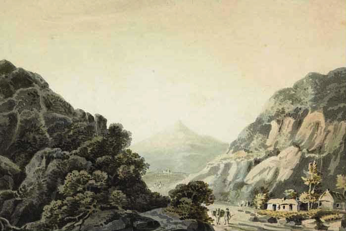
Timoleague Castle, abbey and town, co[unty] of Cork (RIA MS 3 C 30/68)

While we have several Beranger watercolours of Cork subjects, only two, Timoleague (above) and Castlehaven, are from West Cork*. They are the earliest painted depictions of each place, and as such represent incredibly significant records. Each one dates between 1770 and 1799. The description of the watercolour above says: A scenic view of Timoleague Castle, abbey, surrounding town and river [Argideen] Co. Cork. Two men, hauling a boat along the bay are depicted in the foreground of drawing.

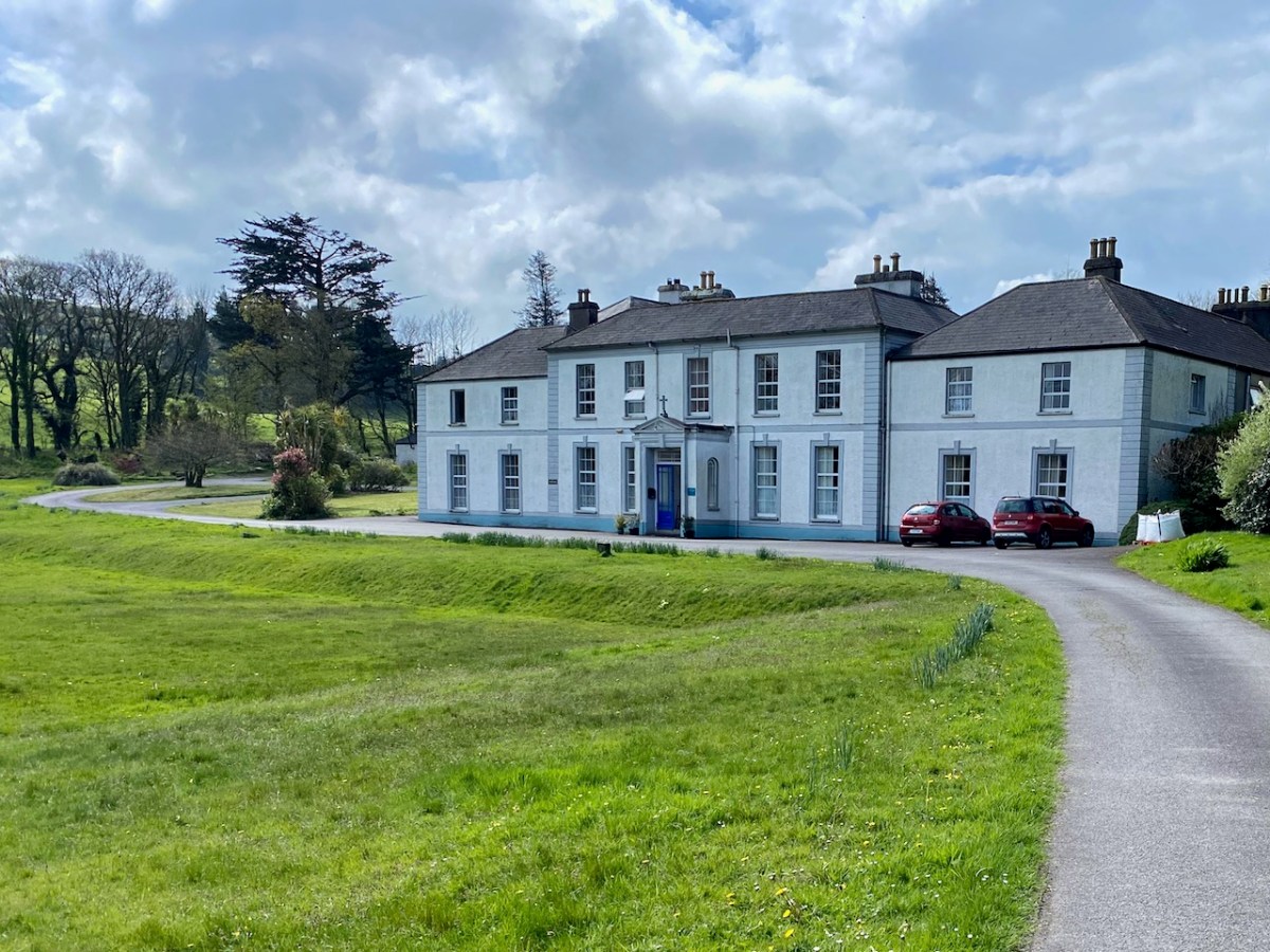
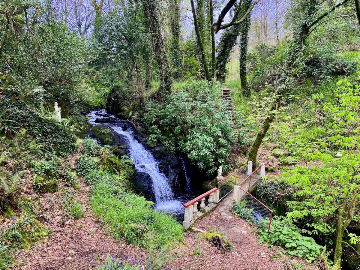
The Abbey (actually a Franciscan Friary) is easily recognisable, but the castle is nowadays hidden behind other buildings. There is no real sign of a ‘town.’

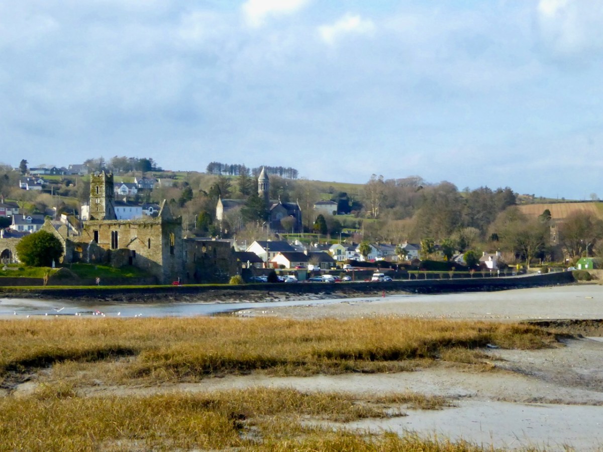
Here’s what it looks like nowadays.

There’s a second drawing of Timoleague, this time done from a different perspective and focussing on the Castle, which is surrounded by an extensive bawn wall.

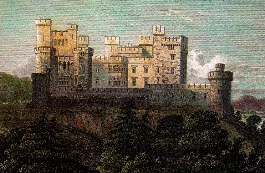
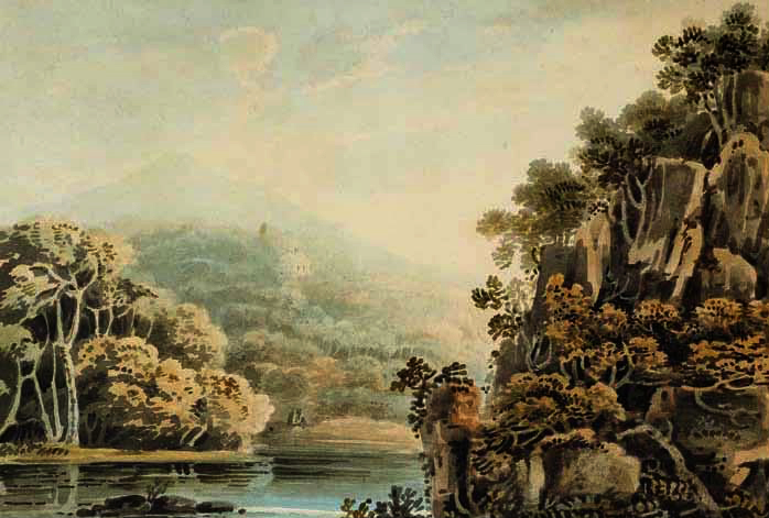
Now on to the watercolour of Castlehaven. It’s beautiful, I think. Importantly, it shows the tower house as complete, whereas it is nowadays only a stub, covered in ivy and brambles.

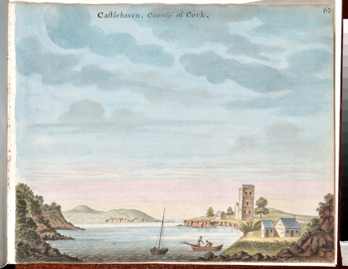
The church in Castlehaven graveyard is shown as a house rather than a church. The small addition to the left end of it may have been, according to Conor O’Buachaille of Gormú, a guardhouse, a feature of graveyards from the grave-robbing era.

Gabriel Beranger , born in around 1729, was from a Dutch Huguenot background, but settled in Ireland in his early 20s. He was a printer and watercolourist who spent a lot of time travelling around Ireland and recording what he saw – often landscapes, but particularly anything of antiquarian interest. Wealthy patrons employed him for that purpose, since antiquarian pursuits were popular among the gentry. Helpfully, he kept notes along the way in a journal. The journal, Beranger’s sketchbooks and some of the watercolours came into the possession of Sir William Wilde about a hundred years after Beranger’s death, and we are indebted to Wilde for most of what we now know about the artist. Wilde wrote a series of posts based on this material for the The Journal of the Royal Historical and Archaeological Association of Ireland, now the Royal Society of Antiquaries of Ireland. Wilde took up a lot of space with his own theories about the antiquities themselves (he didn’t believe that round towers could have been bell towers, for example) but did manage to squeeze in some biographical and professional data about Beranger.

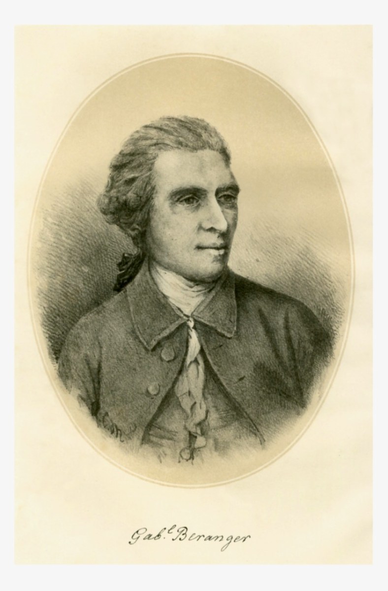
The good old Dutchman was spare in person, of middle height, his natural hair powdered and gathered into a queue; he had a sharp, well-cut brow and good bushy eyebrows, divided by the special artistic indentation; a clear, observant, square-ended nose, that sniffed humbug and took in fun; clear, quick, brown eyes; a well-cut, playful, dramatic mouth, eloquent and witty; not a powerful, but a chin quite congruous with the face. Well shaven, no shirt to be seen, but his neck surrounded with a voluminous neckcloth, fringed at the ends, a drab, rather Quaker-cut coat and vest for household purposes, and when out on sketching excursions he had on a long scarlet frock coat, yellow breeches, top boots, a three-cocked hat, and held in his hand a tall staff and a measuring tape. Like Woverman’s white horse or Petrie’s red woman, he frequently introduced himself in this remarkable but at the time not uncommon costume into his pictures. He was a keen observer of nature, men, and manners, and appeared to relish Irish fun, as indeed his dramatic cast of countenance, shown in the very good crayon drawing made by himself when about middle life, would indicate, and of which an admirable lithograph is appended to this biography.


Memoir of Gabriel Beranger, and His Labours in the Cause of Irish Art, Literature, and Antiquities,
from 1760 to 1780, with Illustrations
W. R. Wilde
The Journal of the Royal Historical and Archaeological Association of Ireland, Fourth Series, Vol. 1, No. 1 (1870),
https://www.jstor.org/stable/25506575

Of his art, this is what Wilde has to say:

He was a most painstaking artist, and a faithful delineator of antiquarian remains. He is said to have been self-taught, and this may account for the hardness of some of his drawings; yet no one of his time could draw an old castle, a cromlech, or a round tower better ; but his extended landscapes were not good, and more resemble plans than pictures. He particularly failed in trees and green fields. Had his observations and descriptions, and his drawings of Irish scenery and antiquities, been published eighty or ninety years ago, they would have caused archaeological study to progress in this country, and perhaps forestalled the opinions of subsequent writers.

Ditto

Then comes the part that is most pertinent to West Cork:

To each volume there is, at the commencement, a copious Alphabetical Index, followed by an ” Advertisement,” stating that ” the castles which com pose this collection I designed on the spot, except the following, which were communicated to me by various gentle men here undernamed, whose kindness I acknowledge with thanks,” &c. From this it would appear that besides his own drawings he obtained, with a view to publication, several others which I am inclined to think he copied with his own hand for the purposes of his work. Among the names of persons who contributed sketches, we find that of Colonel Charles Vallancey as the most conspicuous.

Ditto

Wilde (below, as a young man) died before he could finish his series on Beranger and the last piece was written by Lady Wilde, who occupied most of it with a paean of praise to her husband. William and Jane were at the forefront of the literary of antiquarian movements of their day, and are also, of course, remembered as the parents of Oscar.

There is, as it turns out, no record of Beranger having been in West Cork, although we know he took extended painting trips to several counties – including Wicklow (see my post Antiquarians loved Glendalough) and Sligo (Robert’s Discovering Carrowmore). What we are sure about is that General Charles Vallancey was here, first to manage the defence of southwest Ireland against the threat of French invasion, and then to make a series of grand plans to link West Cork to the rest of Ireland and to the world! I hope to write more of this in a future post.

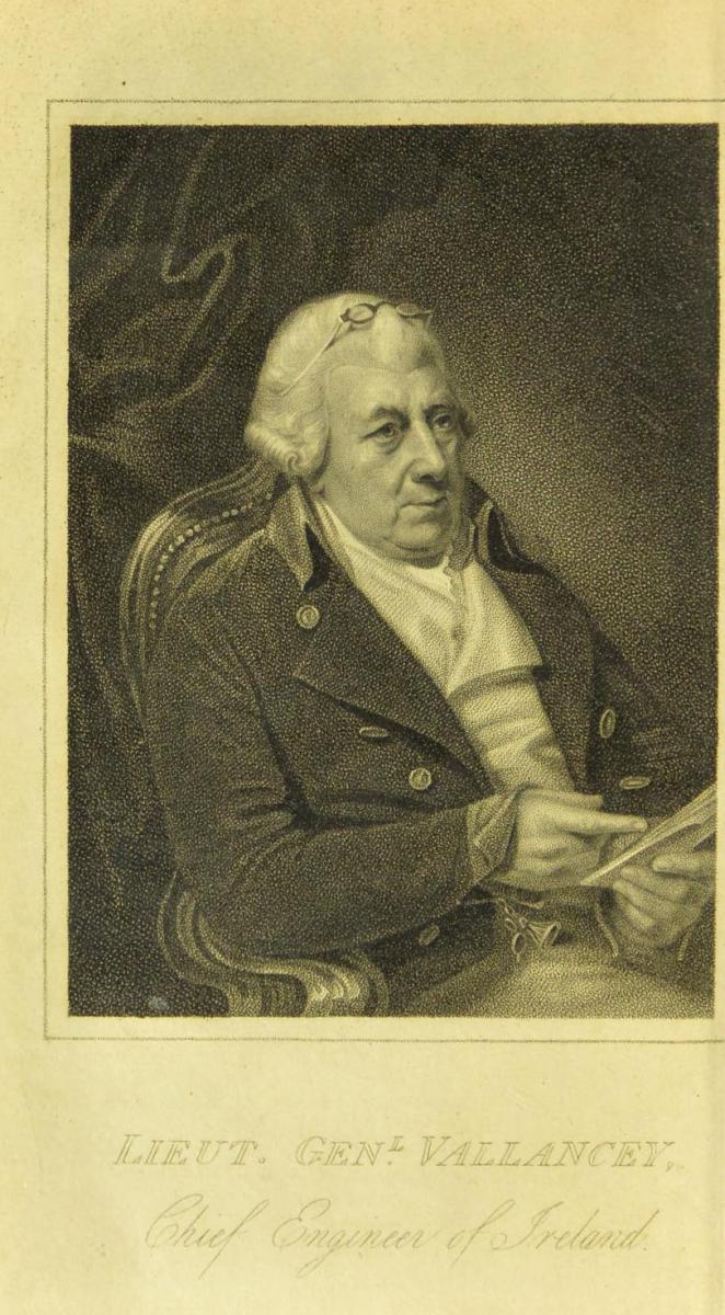
So – whose West Cork is this – Beranger’s or Vallancey? The answer is – both. In the Digital Repository, both are acknowledged as originators. Vallancey was a man of enormous energy and drive. He wrote several volumes of his Collectanea de rebus hibernicis, (available at the Internet Archive) and required illustrations for them – hence his patronage of Beranger, and others. The illustration above is from one of his Collectanea and so he must have wished himself to be depicted this way, as benign and intellectual. Love those little glasses! He was a scholar of Irish – one of the first to raise its profile as an ancient and beautiful language – and an antiquarian of the fanciful sort – forever banging on about druids and Chaldeans and coming up with far-fetched theories. Unfortunately, we don’t have Vallancey’s originals, so we can’t compare the accuracy of the drawings. While we know that Beranger’s reputation was for painstaking exactness, we don’t have the same information about Vallancey’s. To me, comparing it to places Beranger drew on the spot, the rendition of the castles looks a little approximate, especially the fenestration. Nevertheless, as illustrations of two places in eighteenth century West Cork, these watercolours are priceless.

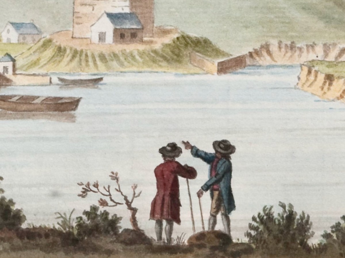
One last detail and quote. Wilde was able to describe Beranger’s dress – that’s because he often put himself in the frame, to add human scale and interest. In his lively piece Beranger’s painted people – himself and others, Peter Harbison gives several examples. But we have our own, from the Timoleague Castle painting. There he is, in his long scarlet frock coat, yellow breeches, top boots, a three-cocked hat, and held in his hand a tall staff and a measuring tape. (Well, more or less.)

Do you know Timoleague and/or Castlehaven well? Can you add to the commentary on those painting? I’d love to have any comments you might have.

*I am grateful to the Digital Repository of Ireland, under whose Creative Commons License I have used these illustrations. See here for more of their Beranger collection.

Wild-Eyed!

It’s just one way of looking at our environment: we are being hunted down by a pair of mechanical eyes on orange stalks. Another way of seeing it is as a public work stand for cyclists! I certainly prefer the former…

It’s a dangerous world . . . You never know what you have to watch out for. Obviously it’s time for another selection of signs and similar. Mostly, these recent examples come from not too far from home. But keep your eyes open at all times – wherever in the world you are.

It has to be Ireland if there’s a carrot in a tree.

Also if there’s a traditional music group on a window-cill.

Friendly advice always welcome…

This one is just down the road from us: it can’t fail to attract customers.

We might call this ‘accidental art’ – it’s a long abandoned hull in a decaying boat-shed near Leap, West Cork.

A very long way from here, as it happens. Perhaps a slightly strange way to sell your services?

This – on the other hand – is service with a friendly face, in Cork Market.

I liked this giant mural on the railway station in Greystones, Co Wicklow.

Another mural – and a few recognisable faces.

A whole lot of the signs in focus today don’t need any comment from me!

Last, but by no means least – the one below greets us every day as we make our way along our West Cork lanes: hope you get a kick out of them all!

You’l find more Irish signs here.

Flower Power – New Ballydehob Exhibition!

I was around in London in the early sixties, and was definitely part of the swinging Flower Power scene: beatniks, Beatlemania, Carnaby Street, flowery shirts and ties (I’ve still got some of them – below – stashed away in my wardrobe!) – the regulation Afghan coat (and its distinctive smell) . . . What I miss most, perhaps, is the purple velvet flared trousers: sadly an expanding waistline quickly did away with them.

What is less well-known – in my generation at least – is the fact that there was a similar cultural phenomenon in one part of Ireland – our own West Cork! And it was centred on Ballydehob – that’s the main street, above. It’s a colourful village today – as it was then: well-suited to the cultural heritage which the artist community of the time imposed upon it. This building on the main street in those early days was particularly significant:

One of the artists who happened upon Ballydehob at that time lived on here to tell the tale (he still lives in the village and is still a working artist):

BREAKING NEWS: BALLYDEHOB IS DISCOVERED!

. . . During the early 1960s, a group of students at the Crawford School of Art in Cork, heard a rumour that something bizarre was happening in a village called Ballydehob. Here some vestige of Swinging London had taken up residence in a painted-up building called ‘The Flower House’. I was one of those students. We decided to investigate.

      Since nobody owned a car, a parental vehicle must be ‘borrowed’. Somebody’s parent was away so this could be done without controversy. One of the know-it-all students announced that Ballydehob was in County Sligo and we would need money for petrol and have to camp when we got there. Nobody owned a tent. A forever-complaining student said that ‘He didn’t want to end up arrested as a vagrant and to have to sleep in a Garda station’. A few days later we left the Crawford en-route to County Sligo. Fortunately, a more astute student rummaged in the car as we were leaving the city for the West, found a road atlas and announced that Ballydehob was actually in County Cork, a mere two hours drive over the potholes. Tent-less or Garda station camping would not be required.

     We arrived, we saw, we were astonished. Cork was then a darkly conservative place, ditto the Crawford and its staff members. What we found in Ballydehob was a house on the main street of the village with enormous flowers painted on the façade. It might have been in Chelsea or San Francisco. We entered to find a hive of creativity and alternative lifestyles. This was the world of women in flowing batik dresses, bearded men with bead necklaces and leather-thonged trousers. Even a cod-piece was observed. We sat in the café and drank coffee from the brownest of chipped brown ceramic mugs, ate inedible brownies and marvelled at the range of art and crafts being produced by this creative group.

      This establishment, which seemed to have landed from another planet since the remainder of Main Street appeared to have experienced no visual or economic change from the images recorded in the black + white photographs of the 1900s, was run by two women, one German, the other English: Christa Reichel and Nora Golden. Here was a living example of William Morris’s dictum, ‘Have nothing in your homes that you do not know to be useful, or believe to be beautiful’.

       Some ten years later, John and Noelle Verling (participants in that epic car journey) set up the Fergus Pottery in Dripsey outside Cork, later transferring it to Christa Reichel’s former premises in Gurteenakilla, Ballydehob, where it became a fixture of the creative community. A few years following, another member of the car-team, myself and Clair, came to stay with the Verlings, and also remained in the area, setting up an etching studio on the other side of Ballydehob.

       Many of those who established the creative community of West Cork have died. Another generation has grown to maturity, further expanding the tradition of West Cork as a major and continuing centre of creative engagement in all of the arts, an epi-centre of delight. . .

BRIAN LALOR

That’s Brian, in his studio today. Just a few years ago – in 2018 – he and I decided that that creative time in the village needed to be properly celebrated, and we gathered around us like-minded enthusiasts, and opened up the Ballydehob Arts Museum, using a room kindly donated by those who had taken over the disused bank building, right in the centre of town:

That’s the inside of the Museum above: its first exhibition opened in the summer of 2018. We had another the following year, then Covid stopped us until last year, when we featured Ian + Lynn Wright. This year’s exhibition also features a ‘couple’ of working artists: The Verlings – Noelle + John.

John Verling was a contemporary of Brian Lalor (who has written the account above), and they both studied architecture and art in London and at the Crawford in Cork. Brian has penned for us his memories of sharing a studio in London with John Verling:

THE PERILS OF A SHARED STUDIO, LONDON, 1967

. . . During the late 1960s, John Verling and I, then students of architecture in London, shared a quite substantial studio in one of the leafier areas of Kensington. The building, a large brightly lit interior behind a row of decaying Victorian villas (it might originally have been a Victorian studio, we never discovered) had many more recent uses and the first task on gaining possession was to somehow manage to get rid of what had been left behind by earlier tenants; office furniture, old matresses, much unidentifiable plumbing apparatus and a stuffed fox whose pelt had been consumed by moths, were among the challenging contents.

     Conversation among acquaintances in our local, the Norland Arms, evoked interest from other drinkers, an English sculptor and a South African photographer who asked could they share the space and, very willingly offered a down payment on the rent. This was agreed and not long afterwards the studio became operational, with both John and myself busy creating in our new-found haven, with only the occasional appearance of our fellow tenants. John was at that point concentrating on elegant photomontages as well as complex drawings of Portobello costermongers and was extremely productive, while I was engaged in a substantial series of elaborate and brightly coloured timber constructions enhanced by scaffold clamps, in a latter-day Bauhaus manner. Time passed, various local artists called to view the work and admire the space. We were exhibiting successfully and the studio became in W H Auden’s phrase, ‘the cave of making’. Our fellow studio members failed to turn up and when occasionally encountered in the Norland, expressed embarrassment in being behind with the rent while offering a contribution to ‘keep their name in the pot’. This was an extremely satisfactory situation with individuals happy to subsidise the rent but too busy to actually attend the studio.

     A chance encounter in the Norland brought another hopeful artist to our acquaintance, David O’Doherty, Dublin painter, he worked at the international telephone exchange. He came, he admired the studio, and invited himself to join. Fatally, we agreed. An accomplished portrait painter, he often had a sitter posed, but seemed happy to work on, undisturbed by the other occupants. Our new tenant was affable, expansive, a storyteller. He became a permanent fixture. Suddenly we realised that we were entertaining a cuckoo in our midst. O’Doherty had moved in permanently, camp bed, small stove on which there was always a fry-up in progress, an endless stream of visitors, large canvasses propped against the wall, and the catastrophic revelation of his other occupation; he was a keen traditional musician, devoted to the Uillinn pipes. Suddenly the space, ample for John and myself to pursue our work, had begun to feel like a home for the demented. 

     Gradually it became apparent that our studio, which a year before had been, in the midst of the city’s turmoil, as quiet and remote as a stylite’s pillar, had metamorphosed into Picadilly Circus with noise, air pollution and crowd control issues. The dream of having a secure place in which to create had floundered on the fatal choice of an individual whose concept of an ideal workplace was perilously close to Francis Bacon’s taste for irredeemable chaos. I bailed out, John lasted a little longer. And the completed series of brightly coloured scaffold-clamp constructions, what of them?  Occasionally I received reports of their travels. Before he emigrated to Boston, O’Doherty sold them to a construction company and they were later spotted decorating the foyer of a social welfare office in Amsterdam. After that only blessed silence . . .

BRIAN LALOR

Noelle Verling (above) studied ceramics at Hammersmith College of Art. She and John met and married and – when they moved back to Ireland in 1971 – John & Noelle Verling established the Fergus Pottery in Dripsey in 1971 with Noelle as potter. She produced a wide range of domestic ware at Dripsey. When they moved in 1973 to Ballydehob to take over Christa Reichel’s studio, they adapted Reichel’s press-moulds and Gurteenakilla pottery stamp for their own work and from then on, traded as Gurteenakilla Pottery and latterly as Brushfire.

. . . The Verlings loved the windswept West Cork landscape and felt moved to record a disappearing environment. John’s paintings often depicted the doors, windows and walls of decaying buildings, repositories for the memories of past inhabitants, long gone. The windswept thorn tree is a familiar motif which connects John Verling with West Cork: the tree became his icon and frequently appeared in his paintings and on his ceramic work . . .

Alison Ospina – West Cork Inspires 2011

This is a rare photograph of John working on one of his favourite subjects: the gnarled thorn tree suffering from the ravages of harsh West Cork gales. Among the architectural work he undertook voluntarily was the reordering of the east end of St Bridget’s Catholic Church in Ballydehob. This was a major work.

. . . The gold fish hand drawn in the background of the altar and the depiction of one fish swimming against the shoal continues to evoke admiration from locals and visitors alike. He also designed the two ‘windswept thorn’ stained glass windows and etched the brass surround of the tabernacle. The Altar slab, composed of a vast monolith like the capstone of a dolmen, is a distinguished piece of sculpture and a tribute to his imaginative capacity . . .

John Verling Website: https://www.johnverling.com

Special thanks to Geoff Greenham for giving us this superb photo of St Bridget’s Church, Ballydehob.

The sign for the Brush Fire Ceramics Pottery, created by Noelle and John. They successfully produced a large number of individual pieces, crafted and fired by Noelle, and decorated by John.

John Verling died in 2009. Noelle Verling is living in West Cork and has been extremely helpful in providing material and information for this exhibition. Without her we would have been unable to fully present this story.

That’s John Verling in the picture above having his legs plastered by Ian Wright: this was part of a publicity stunt for the visit of a large group of West Cork artists to Zurich in 1985. John is also singing a folk song! You can read more about that particular enterprise here.

The Ballydehob Arts Museum is grateful to the town’s Community Council for providing the accommodation for the Museum. BAM is: Brian Lalor, Robert Harris, Sarah and Stephen Canty. Their combined knowledge and practical experience has ensured that our ambitions for this – our fourth exhibition – are fully realised.

ballydehobartsmuseum.com

Exhibition opens Jazz Festival Weekend in Bank House: Thursday 27 April @ 5pm, then Friday 28 April to Monday 1 May: 11am – 4pm. It will open with the Tourism Centre from June to September 2023

Myross Woods

I had the great pleasure yesterday of co-leading a walk through Myross Woods, along with Mark Robins and Conor Buckley.  Mark (that’s him above) is an ecologist, now retired to West Cork (and lucky we are to have him) and Conor is the dynamo who runs Gormú Adventures and who has an inexhaustible store of folklore, mythology,  and local history. My job was to talk about the wildflowers, Mark set the context by explaining what a healthy woodland habitat looked like, and Conor enriched all the narratives with local lore.

So  where, and what, exactly, is Myross Woods? It’s a large House on an estate of the same name, built originally in the mid-eighteenth century by the local Vicar, Arthur Herbert, who sold it eventually to the Earl of Kingston who was building Mitchelstown Castle and needed a place to live while it was under construction.

Mitchelstown Castle was one of the most impressive Castles ever built in Ireland. It was looted and burned by the IRA in 1922. 

Mitchelstown Castle. Originally published in 1820 in “Views of the seats of noblemen and gentlemen, in England, Wales, Scotland and Ireland.”, Public Domain, https://commons.wikimedia.org/w/index.php?curid=16264046

It was probably the Earl who set about designing the landscape as a series of vistas and pleasure gardens to impress his guests – his guiding principle seems to have been that ostentation should be given priority (he specified that Mitchelstown Castle should be the biggest in Ireland). The eighteenth century was the era of the Designed Landscape. As I said in my post on Belvederes 

The effect they strove for was naturalistic (as opposed to natural) – a planned layout that mirrored but enhanced their idea of a ‘wild’ and romantic landscape. Large expanses of grass, strategically placed lakes and ponds, plantings of carefully chosen tree and shrub species, and clever little structures such as temples, summer houses and belvederes all combined to delight the eye, create a romantic mood and, of course, attest to the taste and wealth of the owner.

Capturing the View: Belvederes in West Cork

One of Kingston’s enhancements was to carve out the rock to create a waterfall. I wonder how he and his Protestant guests would feel if they knew that the Missionaries of the Sacred Heart, who ran Myross Woods as a retreat house for most of the twentieth century, had turned his sylvan feature into a Marian Grotto.

In the case of Myross Woods there is good evidence that there was an existing and ancient woodland, since some of the indicator species are present. Believe it or not, one of those species is the native Bluebell (Hyacinthoides non-scripta), which flourishes in ancient woods. Another is the Woodrush (ditto, above) which is identified with oak forests, such as we have at Myross Woods, as well as Wood Sorrel (above).

Kingston set about enhancing the environment by planting Beech Trees, by carving out clever little waterfalls, by building an impressive entryway featuring a hand-hewn tunnel, by walling a garden behind the house, and by all the interventions that were used at the time to create imposing carriage drives, romantic vistas and delightful walks. 

As you can see above, the 1840s map and the modern map illustrate that the woods have remained more or less as they were, in terms of location and extent. It’s the composition of the woods that is the issue. The presence of Sanicle (below), for example, indicates that non-native Beech trees were introduced here (Sanicle typically grows under Beech trees).

While it can be hard to say in places where the original woods leave off and the new plantings begin, for the most part the interventions are fairly obvious. This creates a dilemma for those committed to restoring the woods. For example – the Killarney Fern is found here (below). Incredibly rare, it’s one of Ireland’s three types of filmy fern. Is it native to these woods or was it introduced by those fern-mad Victorians? Whichever it was, its presence here is what has conferred on these woods a Special Area of Conservation order. The fern requires shade, and that shade is currently being provided by invasive Laurel – see the problem?

The Friends of Myross Woods has been set up to support the creation of a living, community woodland resource for biodiversity, education, recreation and the arts. They have been hard at work on a long-term project to restore the woods to something closer to a native woodland. They want to gently shift the site from a mixed broadleaf woodland to a more oak dominated birch and holly woodland (the most natural woodland type for this area).

On our walk Mark pointed out what has been accomplished and the immense amount that needs to be done. YOU CAN HELP! Sign up to become a Friend of Myross Woods, see what you can do to help, or make a donation to their efforts. Think how good you will feel, knowing you are doing your bit for this wonderful environment.

But even if you can’t do any of that, just go and take a walk in the woods – it’s open to everyone and it’s a restorative experience at any time of the year. There are two walks you’ll want to do, both short and easy. The first of the one to the south of the house, leading down to the water of Glandore Harbour. This is the walk we did yesterday.

The second is the Tunnel Wood walk, near the N71 entrance. It will bring you to the tunnel, dripping with bryophytes (mosses and liverworts) and on to the amazing bridge that Kingston had built to provide a suitably opulent entry to his demesne. Be careful here, though – it’s high and precarious.

Myross Woods is just one branch of the great work that is being done by CECAS (Centre of Excellent for Climate Action and Sustainability), an initiative of Green Skibbereen. By signing up to support CECAS you become part of a movement that is stepping up and actively tackling climate change in our West Cork Community.

The Magic of Old Maps

We’ve done quite a few posts over the years about old maps – we are both fascinated by them. So I’ve decided to draw all those posts together into a new Menu Page, so you can easily find any post you’re interested in.

Several posts went into detail about maps from the Elizabethan period. The Elizabethans were map-makers and they had a special interest in drawing up maps of Ireland – to confiscate tracts of land from the rebellious Irish and assign them to colonisers. Jobson was the cartographer who mapped Munster: two posts detail the maps drawn up for that purpose.

There’s a mysterious map in the British Public Record office – nobody knows who did it, but it was obviously done in the period following the Battle of Kinsale in 1601. While some of the elements are obvious, others are not, and pouring over a map like this raises as many questions as it answers. I titled the two posts Elizabethan Map of a Turbulent West Cork.

Two posts, Mapping West Cork, drew on maps from the David Rumsay Map Collection – a man who has done the world a great service by collecting and digitising maps from all over the world. These are very early maps by famous cartographers Mercator (done in the late 1500s) and Blaeu (from his 1655 Atlas). I’ve updated this post recently.

John Speed’s map, dating to 1611, although largely based on Mercator’s work, is more detailed and adds all kinds of interesting details about people and cities.

Robert’s post Roaringwater Bay in 1612 is about the Dutch Pirate Map. As he says in his post:     The thing that sets the 1612 map apart, however, is that it was made in secret, and largely from surveys only carried out at sea. Also, it was specifically intended to enable a Dutch fleet to assail the pirate strongholds which became numerous around the area from Baltimore to Crookhaven, centred on Roaringwater Bay and ideal for forays into the wider Atlantic trade routes.

A series of three posts, all written by Robert, explored the world of the Down Survey – conducted by William Petty under the instructions of Oliver Cromwell, and like the Jobson maps, done for the purposes of assigning land to colonisers. 

After an introductory post, Robert went into details about West Cork and then, in a third post, looked at Kerry. He is planning more in this series.

Finally, there’s Griffith’s Valuation – a series of detailed maps done by Sir Richard Griffith in the 19th century for the purpose of putting values on every square perch of land. Robert wrote about Griffith in The Rocky Road to Nowhere, and I used the Valuation in my post What the Forest Was Hiding.

We will update The Magic of Old Maps page as we write any new posts. I am leaving you with a new map – it’s the joint work of Robert and Peter Clarke, and the original hangs in the Bank House, Ballydehob’s Tourist Information Centre.

If you want to browse the David Rumsey map collection for yourself, it’s here.

Sugar Loaf

We were unexpectedly in County Wicklow, and had a day or two of sunshine. To take advantage of this, we found our way up to the Great Sugar Loaf, with every good intention of climbing to its peak – 501 metres above sea level. I’ll come clean and mention that the starting point for the walk is already halfway up this elevation – and also we didn’t make it all the way on this occasion, as we were heavily overdressed! Only yesterday we still seemed to be in the grip of a very harsh winter, so had assumed that gloves, scarves and thick jackets would be the order of the day. In fact, quite a few other climbers were clad in tee shirts and shorts…

The upper view was taken on the path going up to the top – this morning. The lower view – taken a couple of years ago from Bray Head – gives a good impression of the Great Sugar Loaf (the furthest peak on the right) as the high point in a range, rather than a lone conical summit. There is also a Little Sugar Loaf which – in this view – is the high point in the central range in the photo. From other places, the ‘Little’ loaf also appears like a conical ‘peak’. Have a look at the pic below, where I have tried to show both ‘cones’ in the same view.

This photo, which dates from the early 1900s, is taken from the old beach in Greystones: the Little Sugar Loaf is over to the left, while the ‘Great’ one is at the left end of the further ridge (photo by William Alfred Green (1870–1958) – courtesy of Ulster Folk Museum). Below – the same view of the two ‘sugar loaves’ taken from the Marina, Greystones, today.

Here’s another view of the ‘Great’ loaf, with further pics of today’s adventures below, including the prospects from on the hill:

The area deserves considerable further exploration. The extracts below are from the Schools Folklore Collection, recorded in the 1930s: valuable commentary and memories collected from local inhabitants.

. . . If we were to visit Kilmacanogue over a hundred years ago it would present to us a very different appearance from what it does now. Our journey would be by the end of the Sugar Loaf Hotel of today, up the school lane, turning west for about a quarter of a mile and crossing the present day Rocky Valley road and following in a south-western direction along the foot of Sugar Loaf mountain. On our left was a church (in Brerton’s Garden) but not even the ruins of this remain. It is said the monks fled from this church in the Penal days, burying behind them their gold chalice, which still lies hidden in the field still know as the Church field. The road leading from Kilmacanogue to Kilmurry (now known as the Old Road) was the Coach Road between Dublin and Wexford. At the Kilmurry end there is a plot of ground about one acre known as Kilmurry Green which is believed to have been an old burial ground. The lane leading off from this road to the present main road near Kilmurry Dispensary locally known as Connolly’s Lane is supposed to have been lined with houses. The field on the North side of this lane (now in the possession of Miss Powell) is called the Street Field which indicates that a village must have been there at one time. The south part of Kilmurry Green contains the sites of two buildings – the stones, are still to be seen there, which marked the foundation of the gable. Traces of graves remain, though the place has not been used as a burying ground within any person’s memory . . .

Schools folklore Collection Kilmacanogue, Bray
Teacher: Caitlín Ní Chuinneáin

The Great Sugarloaf was a popular subject for artists. Examples are these watercolours: from Views of Bray and the Sugarloaf, County Wicklow, circa 1820 John Henry Campbell (1757-1828) – Whytes.ie. Back to the Schools Folklore Collection: we were particularly interested in the mentions of Red Lane, where there was evidently once a church, burial ground and holy well: it is said that none of these are visible today, but we will pencil in some further visits to have a closer explore.

. . . At the Southern extremity of Kilmurry bordering on Calary are two ruins which are popularly called Leghteampall or the Monasteries. These ruins stand in two adjacent fields, separated by a narrow lane (Red Lane). They lie east and west of each other in the Kelly’s and Whelan’s land, that in the west forming a square of thirty two yards each way. On the south side stands an angle of ancient wall built of stones and mortar 4′ 2″ high 2′ 2″ thick. There is a clump of stones and thorns at the north side 30′ long by 12′ broad and 2’2′ in height. There is an ancient holly tree in full vigour at the south-east angle a cross is cut in the tree and funerals stopped here and recited the prayers for the dead. About thirty yards east of there are the traces of an ancient church. A few stones of irregular shape remain in the foundation of the south wall; the stones appear to have been carried away from the north side within a comparatively late period. A heap of stones and rubbish occupies the place of the western gable, along which lies a large shapeless lump of a stone, having at the top a rudely formed cavity 7″ deep and 9″ in diameter at top, narrowing gradually to the bottom. This was a holy water stoup, one of the rudest ecclesiastical antiquities. An ancient decayed ash tree stands on the north of the church and graves may be traced in several places around it, though it has not been used as a burying ground for a long time. About a furlong south west of this place is a holy well called Bride’s Well (in Chapman’s Lane) at which Patrons were held, but none was held there within the last forty years . . .

Schools folklore Collection Kilmacanogue, Bray
Teacher: Caitlín Ní Chuinneáin

This winter scene is courtesy of Wiki Commons: we would like to visit at that time of the year, although the mountain may well not be hospitable then. Below – that’s the somewhat unusual gateway to the car-park at the Great Sugarloaf: take care when entering!