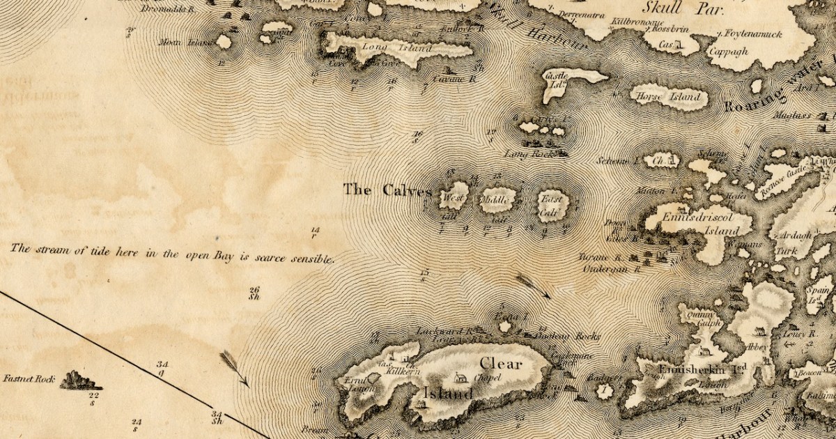
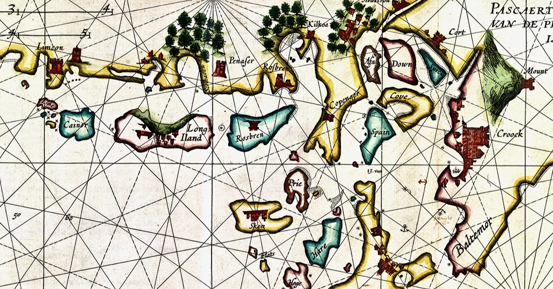
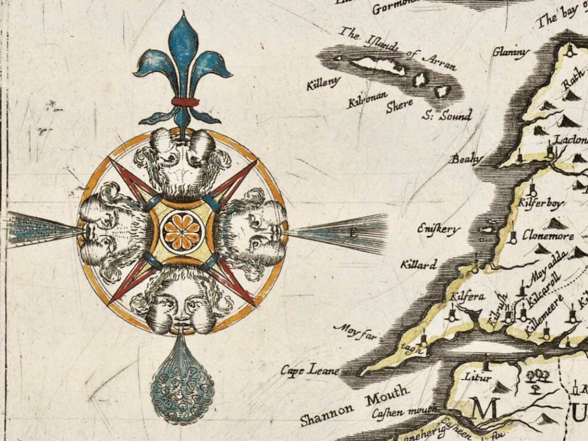
The first thing to say about this map is that on it the name Roaringwater Bay is assigned to a restricted area area eastwards from Horse Island, up to the entrance to Ballydehob Bay, and across to Skeaghanore, Kilcoe and Turk Head. This, in fact, is still how modern maps are labelled.
However, when you live here, you realise the term Roaringwater Bay is used to refer to the whole area that encompasses all the Islands, right out to Cape Clear. In Irish, Roaringwater Bay is called Lough Trasna, which simply means Lake ‘Across’ – a term which carries the implication of a body of water you have to cross over.
And how did it get the name Roaringwater – the official version is that it’s called after the Roaringwater River, which in turn gets it name from the way the water roars as it tumbles over rocks. But read my post from way back in 2014, The Roaring, and you will realise that there is a much more sensible explanation. So I will use the term Roaringwater Bay in this post as we use it every day around here – to include everything you see from the top of Mount Gabriel, looking south and east, as below. Before I move from the image above, however, let me point out Kilcoe Church, and Kilcoe Castle, both of which I have written about.
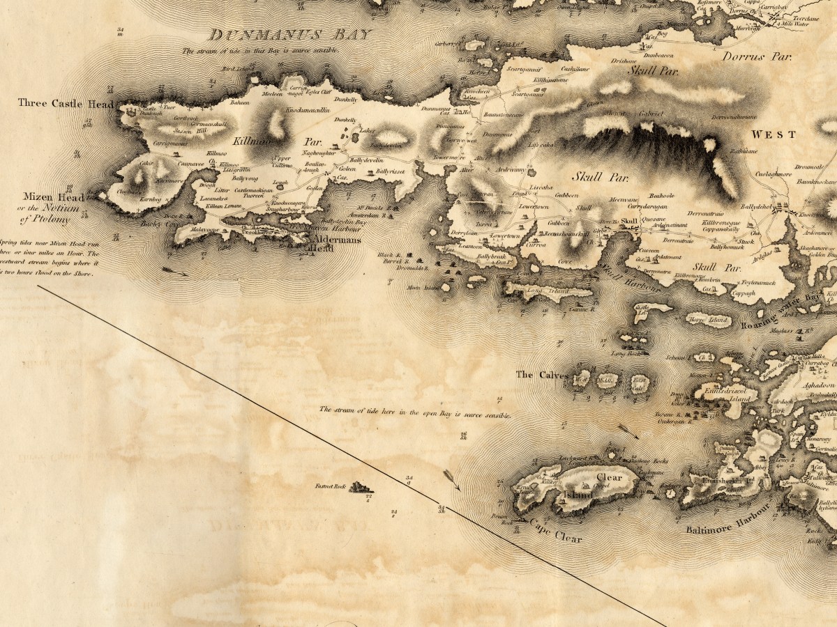
Let’s start with the biggest island – familiarly known locally as Cape Clear. Clear Island, as it is properly called (Oileán Cléire) and as it is labelled on this map, shows the name Cape Clear reserved for its southwestern tip.
Dún an Óir Castle (see this post, and this one) is clearly shown, as is St Kieran’s Church, which was a ruin even then. Intriguingly, there is a Catholic Chapel shown which must have been in place before the current church was built in 1839, approximately in the same area. Even more strange is a building shown as a ‘Gentleman’s Seat’ – that is, a Big House, on the south side of the Island. Can anyone help us with that this might have been?
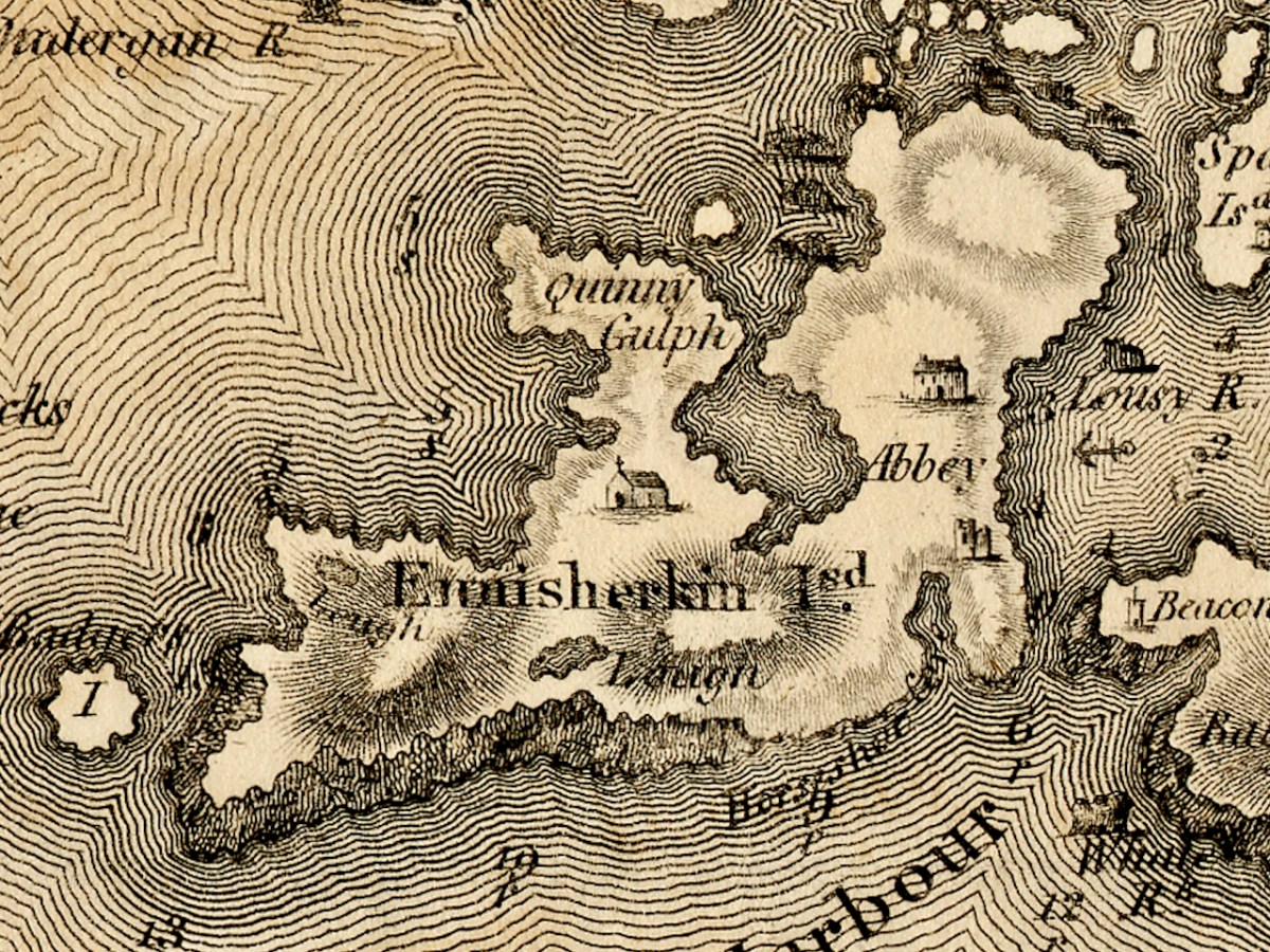
Sherkin Island is shown as Ennisherkin. This is from the Irish Inis Arcán, translating literally as Piglet Island, but likely from the Irish word for porpoise, which is muc mara, or sea-piglet. Anyone who has boated in the area will know how prevalent porpoises are in the seas around the islands. Once again, we have a catholic chapel, and of course the ruined Abbey and castle. Take a look at my post A Walk on Sherkin Island for a taste of what that’s all about. The term Quinny Gulph, by the way, must be Kinnish Harbour, the large bay in the centre of Sherkin. Once again, we have a ‘gentleman’s seat’ on Sherkin, and once again I am asking readers to identify this.
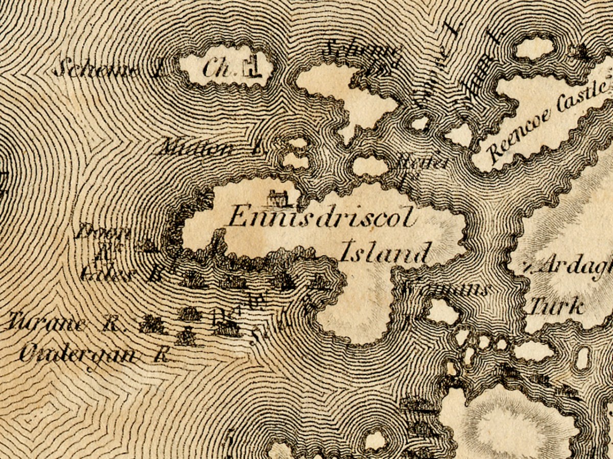
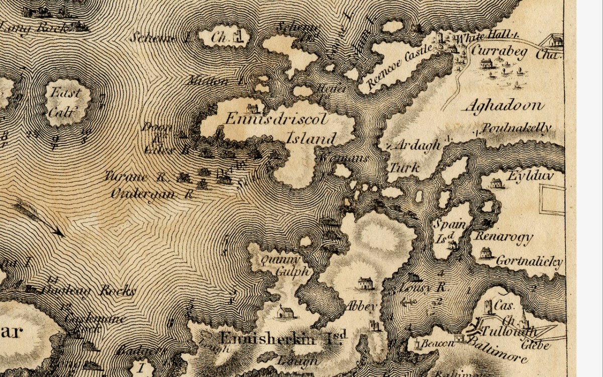
Ennisdriscol Island is of course now called Heir Island – the older name indicating that it was very much the domain of the O’Driscolls in the past. It’s curiously featureless on this map, apart from yet another large house. Right above it are the Skeams, East and West, or the Schemes, as Bath has it. West Skeam has a pre-Romanesque church on it which I have yet to explore – a new blog post one day! I’d better hurry – it’s in a perilous position on the edge of a cliff and much of it has already been swept away.
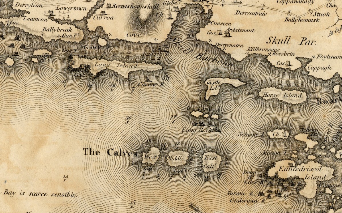
The Calves, now uninhabited, occupy the middle ground of Lough Trasna between the mainland and Cape Clear, while Long Island, Castle Island and Horse Island parallel the coast. Horse Island and Castle Island are each now owned by a single individual, while Long Island still has a resident population of several owners. The vestigial castle on Castle Island is not shown. To the east of Long Island is Goat Island and Goat Island Little – the cleft between them is actually much narrower than appears on Bath’s map and only navigable with care by kayak. It is home to a herd of feral goats.
And finally Spain Island, now called Spanish Island, and the western end of Ringarogy. Note that the only one of the small islands scattered between Sherkin, Turk Head and Heir Island that is named on this map, is Woman’s. In fact, there is a tiny rock in this area labelled on modern maps as Two Women’s Rock. The largest island in this group is actually called Sandy Island and the smaller ones are The Catalogues. Note also that the castle now called Rincolisky, is here labelled Reencoe. And let’s include Baltimore, with its castle and – the beacon!
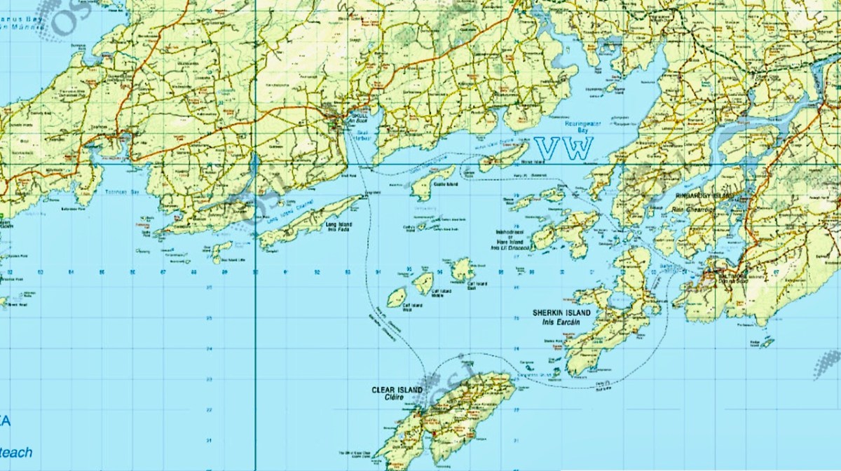
I know we have been a bit forensic about the area I call home – my next post will take a much broader look at West Cork. Here’s a sneak peak.
As readers know, I love old maps and there’s a map of Cork I haven’t written about yet. This is a truly beautiful piece of work, and a huge step forward on some of the older maps of Cork I have described – for the list, see my page The Magic of Old Maps.
Since it will take me more than one post to talk about this county map properly, I will start today by concentrating on Map 4, and stick to the Mizen Peninsula. The map is in 6 parts and I am able to share it with you today through the generous assistance and permission of the Cork County Library. You can view their hi-res images here – they may be sharper than mine, as I do have to compress images for the blog.
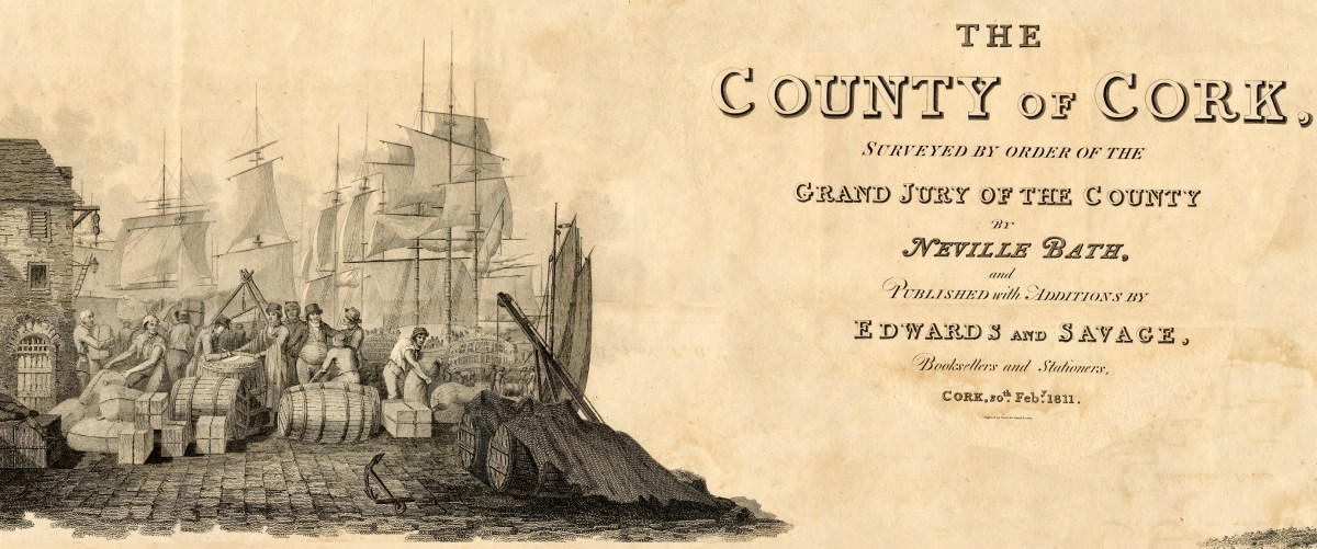
But first, some context… We assume that proper, professional mapping really got underway with the Ordnance Survey in the 1830s, but indeed there were competent cartographers in Ireland before then. Neville Bath was one. In an essay by J H Andrews (see reference in the final quote) he is described as English but spending his whole cartographic career in Ireland, starting off by drawing estate maps in Kerry. He finished a map of Cork City in 1788, so was well placed to be awarded the contract for the county map, when the Irish parliament allowed public money to be spent on producing Grand Jury barony maps as well as county maps, but only for official purposes and only in the form of manuscript ‘protractions.’ Bath tried to arrange for the manuscript protraction to be turned into a proper published map by selling subscriptions – that did not go well, and it wasn’t until 1811 that the map was finally published, engraved by the London firm of S J Neele, acknowledged as the finest artists in the Kingdom.
What was a Grand Jury and why were they commissioning maps? As the name suggests, Grand Juries were initially conceived as groups of 24 men (yes, only men) who wielded authority for the administration of the criminal justice system in Ireland. The exclusive domain of wealthy landlords, the Juries exerted enormous power over the whole population – a population with which they had little in common, including economic status but also language, religion and cultural affiliation. Over time, the Grand Juries accumulated other responsibilities, for roads, bridges, hospitals, schools and tax collection.
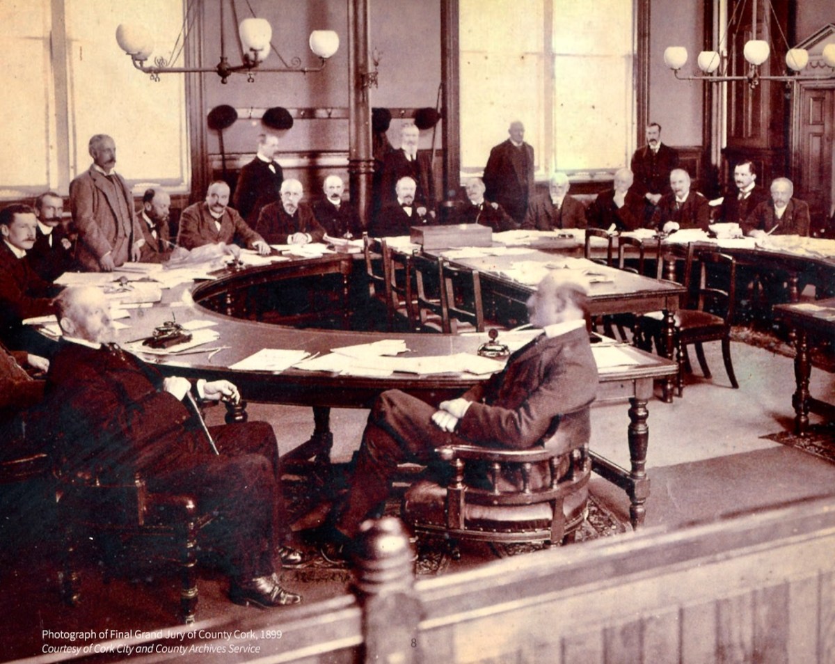
Eventually, all those duties were taken over by other bodies – County Councils, the Poor Law Union, a proper legal system. Above is the final sitting of the Cork Grand Jury in 1899. But while it lasted it was already an archaic system, deeply unfair and rife with corruption. It also became highly competitive, with one Grand Jury after another building more and more elaborate courthouses*. The same thing happened with maps:
Almost inevitably, the maps enabled each grand jury to convey its own prestige to its neighbours, and the ‘Grand Jury map’ project took on an increasingly expensive and stunningly elaborate life of its own. William Larkin was the greatest exponent of the genre and produced maps for six out of the twenty-six counties that made it into print using the public purse. Larkin produced maps for Westmeath (1808), Meath (1817), Waterford (1818) and Galway, Leitrim and Sligo (1819). From 1784 grand juries were required to have their county map ‘put up, and kept constantly during the assizes in the grand jury room of said county’.
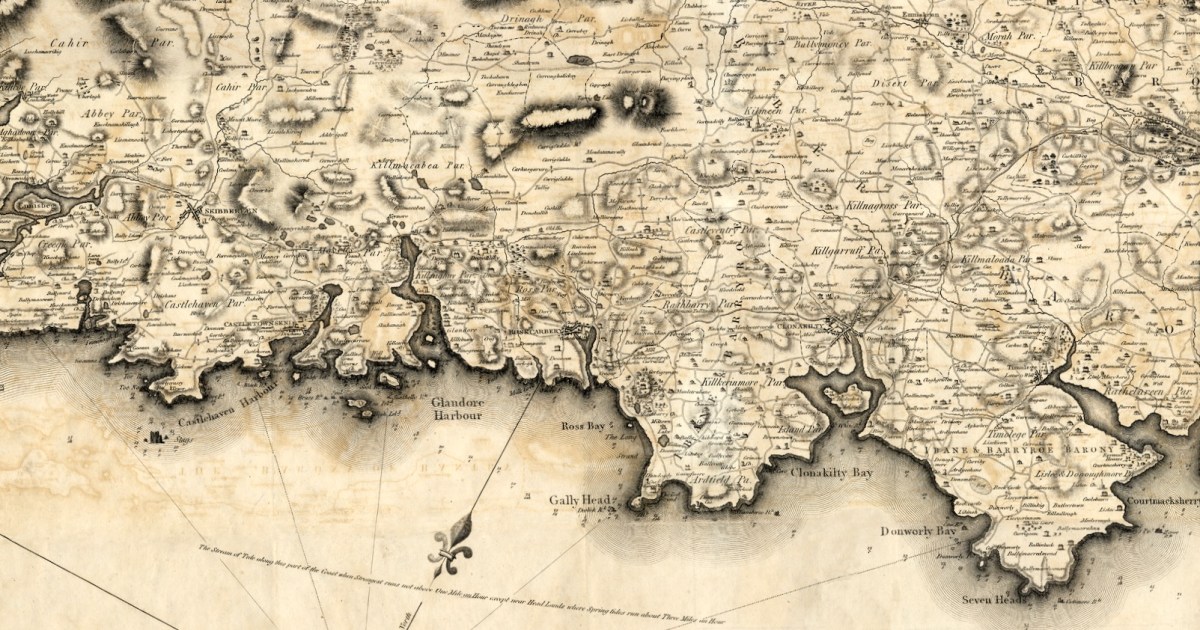
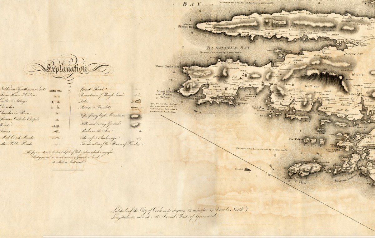
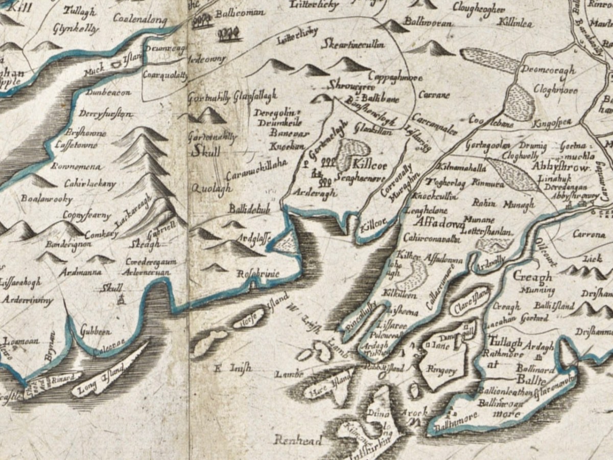
Let’s take a look at Neville Bath’s map now, working from west to east along the Mizen Peninsula. you will have your own favourite spots to check out – I am just going to point out a few of interest to me.
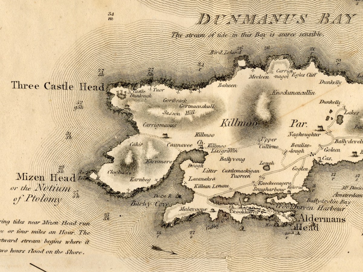
This map pre-dates Richard Griffiths road-building along the Mizen, but nevertheless it shows a road going all the way to Crookhaven. I love the little depiction of Dunlough/Three Castles, and also that a church is shown at Lissagriffin – we can see the ruins still. Alderman’s Head is called Streek Head on the early OS maps, while the rocks offshore at this point are called Alderman’s rocks. (Who was the Alderman, I wonder?)
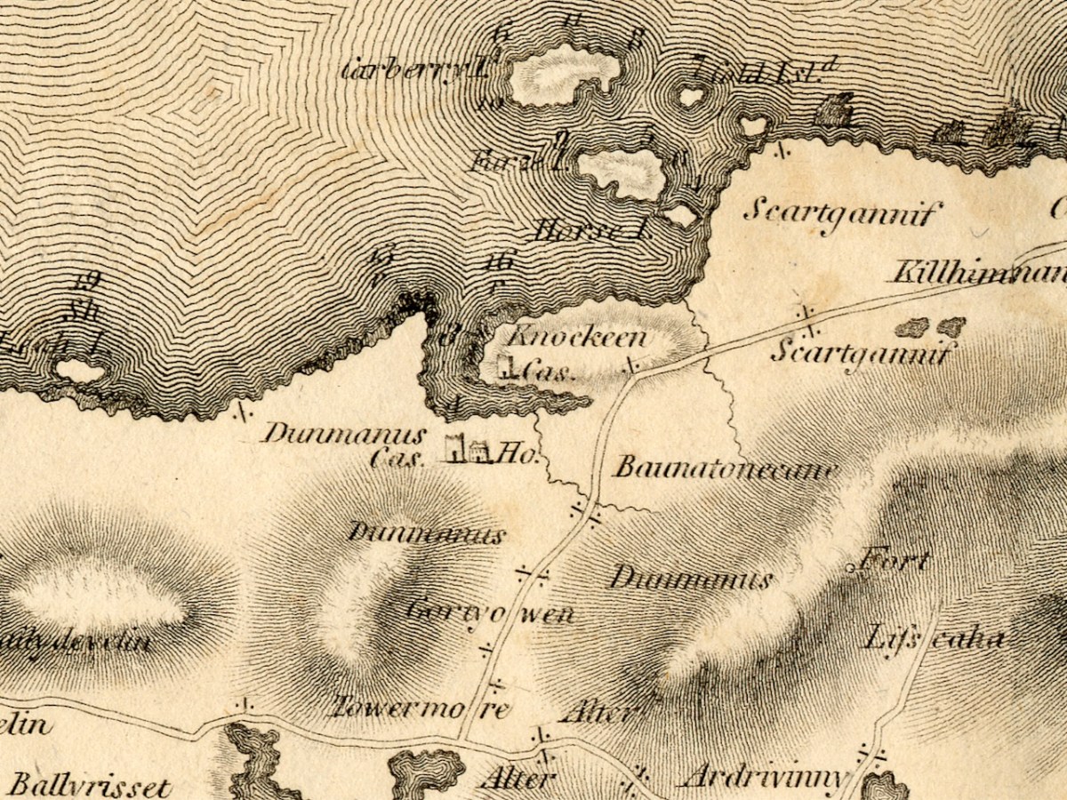
Before we move East to Schull, I just want to highlight Dunmanus. The ‘castle’ at Knockeens is clearly shown. As I discussed in my post Dunmanus Castle 1: The Cliff-Edge Fort, there is much much local folklore about this site. There may have been more to see when Bath was mapping this area.
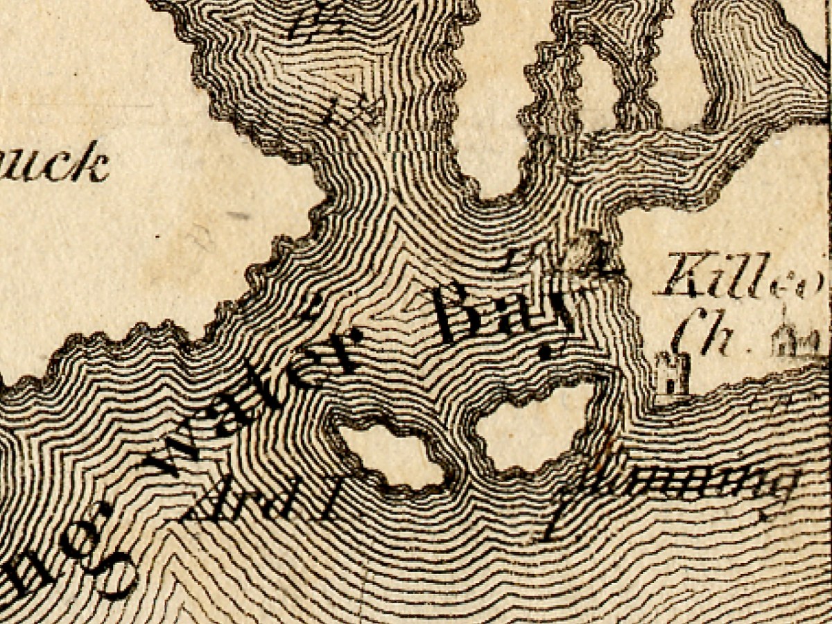
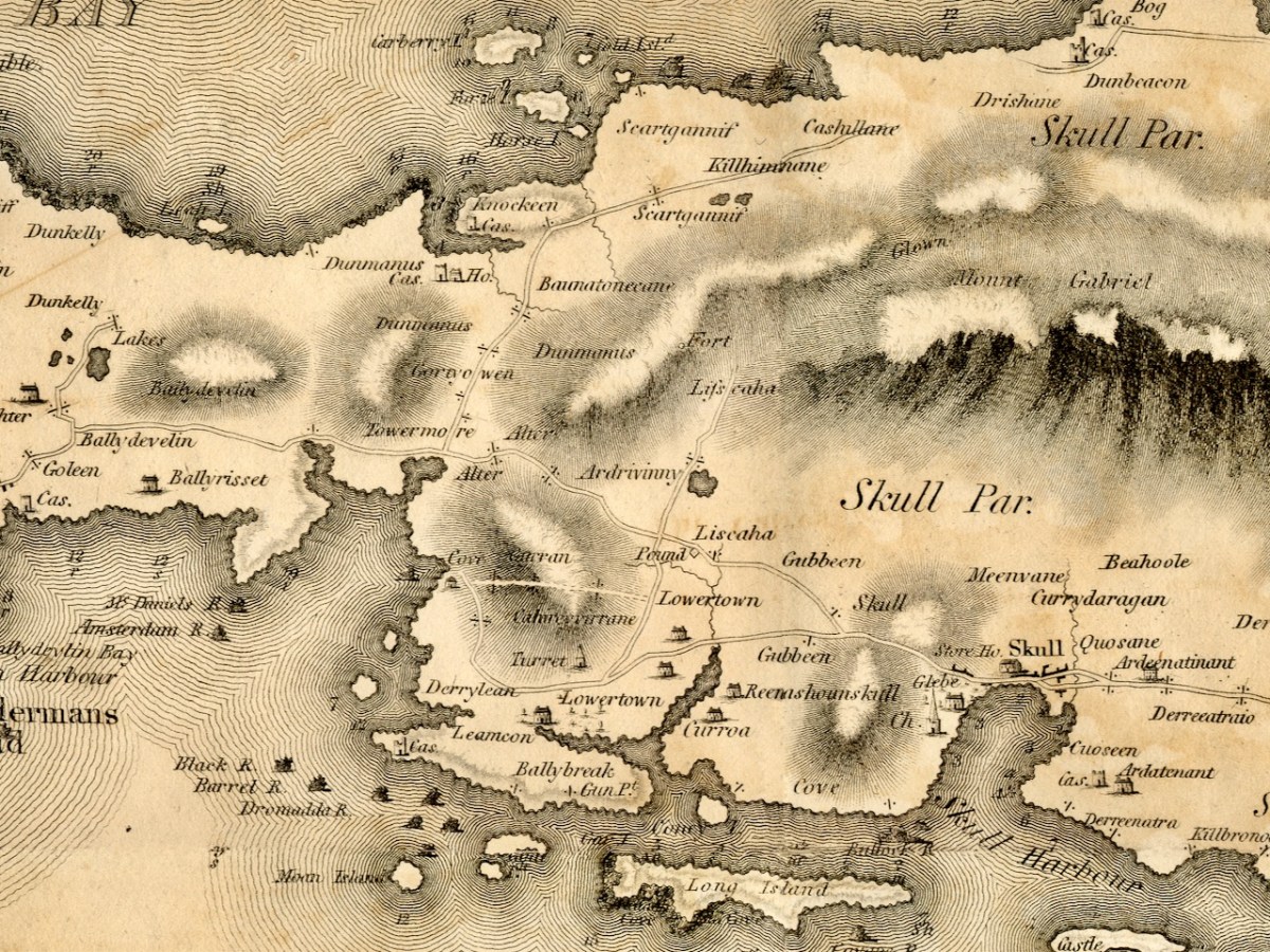
Moving towards Schull, I am intrigued by the noting of a ‘pound’, which does not occur on later maps. A pound was used to secure animals seized by the landlord’s agents for payment of rent. Note also the ‘Fort’ at the end of the Lisscaha road. While I haven’t written about this fort, I have visited it, and very impressive it is.
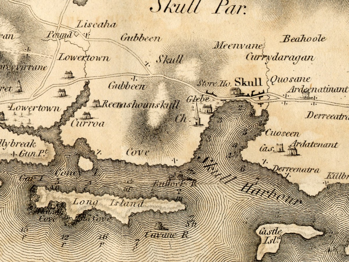
Schull is shown as a sizeable settlement, with a storehouse, Glebe, and Church – St Mary’s Church, now replaced by Trinity Church. A number of Gentlemen’s Seats are shown in the vicinity.
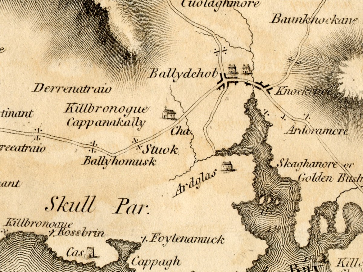
And finally we arrive at our own Ballydehob, shown as a town. Note the church to the south west of the town – I wonder if this is the church that once stood in Stouke Graveyard. It hadn’t occurred to me that Skeaghanore was the Irish for Golden Bush – there must be a story there! We will cover other parts of West Cork in subsequent posts. This map is an incredibly valuable resource dating as it does from well before the Ordnance Survey. We are lucky that it was published and copies saved. But what happened to Neville Bath? As JH Andrews tells us, Bath
may well have been dead by the time his work was officially published on 20 February 1811, and the map itself was only just in time. Irish cartography was about to pass into the hands of a new elite, engineers rather than land surveyors, whose most distinguished members were immigrants from Britain like Alexander Nimmo and William Bald. This later generation had a low opinion of Bath, and within fifteen years of his departure the counties of Limerick, Tipperary and Kilkenny had all decided to have his work done again. Not surprisingly, none of his manuscript county surveys appears to have been preserved. The map of Cork is available in a number of Irish libraries, however, and only awaits the judgement of the county’s own historians.
We’ve done quite a few posts over the years about old maps – we are both fascinated by them. So I’ve decided to draw all those posts together into a new Menu Page, so you can easily find any post you’re interested in.
Several posts went into detail about maps from the Elizabethan period. The Elizabethans were map-makers and they had a special interest in drawing up maps of Ireland – to confiscate tracts of land from the rebellious Irish and assign them to colonisers. Jobson was the cartographer who mapped Munster: two posts detail the maps drawn up for that purpose.
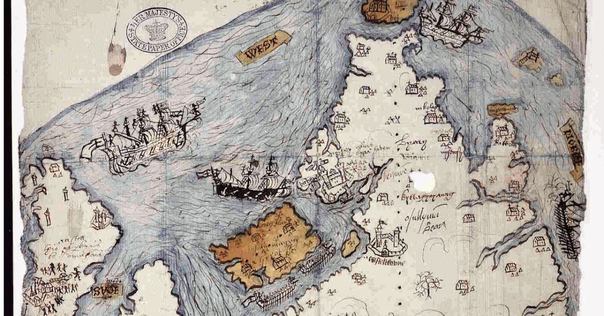
There’s a mysterious map in the British Public Record office – nobody knows who did it, but it was obviously done in the period following the Battle of Kinsale in 1601. While some of the elements are obvious, others are not, and pouring over a map like this raises as many questions as it answers. I titled the two posts Elizabethan Map of a Turbulent West Cork.
Two posts, Mapping West Cork, drew on maps from the David Rumsay Map Collection – a man who has done the world a great service by collecting and digitising maps from all over the world. These are very early maps by famous cartographers Mercator (done in the late 1500s) and Blaeu (from his 1655 Atlas). I’ve updated this post recently.
John Speed’s map, dating to 1611, although largely based on Mercator’s work, is more detailed and adds all kinds of interesting details about people and cities.
Robert’s post Roaringwater Bay in 1612 is about the Dutch Pirate Map. As he says in his post: The thing that sets the 1612 map apart, however, is that it was made in secret, and largely from surveys only carried out at sea. Also, it was specifically intended to enable a Dutch fleet to assail the pirate strongholds which became numerous around the area from Baltimore to Crookhaven, centred on Roaringwater Bay and ideal for forays into the wider Atlantic trade routes.
A series of three posts, all written by Robert, explored the world of the Down Survey – conducted by William Petty under the instructions of Oliver Cromwell, and like the Jobson maps, done for the purposes of assigning land to colonisers.
Finally, there’s Griffith’s Valuation – a series of detailed maps done by Sir Richard Griffith in the 19th century for the purpose of putting values on every square perch of land. Robert wrote about Griffith in The Rocky Road to Nowhere, and I used the Valuation in my post What the Forest Was Hiding.
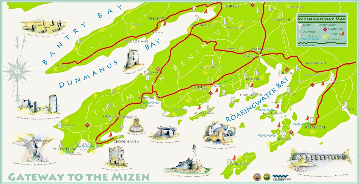
We will update The Magic of Old Maps page as we write any new posts. I am leaving you with a new map – it’s the joint work of Robert and Peter Clarke, and the original hangs in the Bank House, Ballydehob’s Tourist Information Centre.
If you want to browse the David Rumsey map collection for yourself, it’s here.
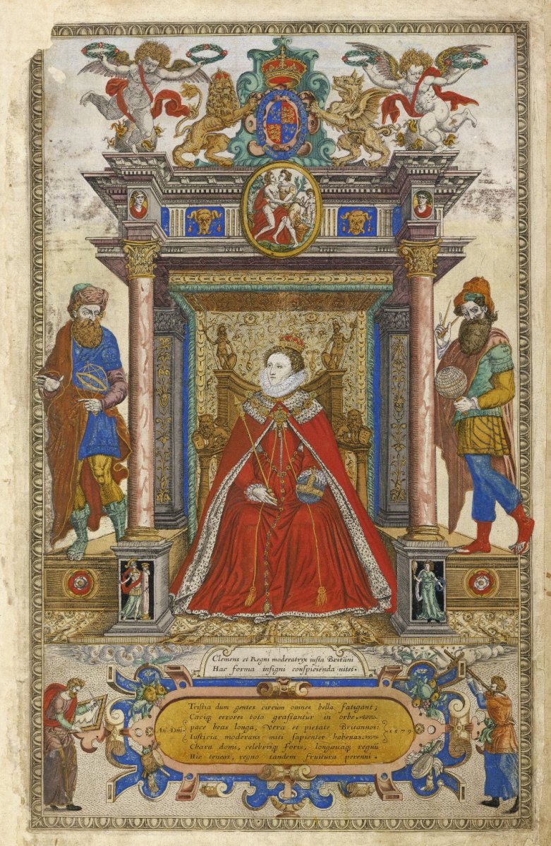
As I said in Part 1, this map was made to provide information for the purposes of plantation – that is, colonisation – of Munster, and in particular of those lands forfeited by the Desmonds after their ill-fated rebellions. Jobson, the cartographer who signed this was, according to Andrews, an enthusiastic map-maker who was unusually determined that his maps would survive. Accordingly, he made copies and presented them to likely future employers – hence this one, inscribed to Lord Burleigh, faithful and long-serving eminence grise to Elizabeth 1. That’s herself, below. (Full citation for the map is at the end of the post.)
He also showed unusual zeal in presenting duplicates to likely patrons: no one was going to deprive posterity of a Jobson map by “borrowing” the only copy. Other features of his complex cartographic persona were more distinctly Irish, such as his deceptively slapdash-looking style and his apparent ignorance of earlier Anglo-Irish cartography.
Much of the ‘slapdash’ nature of the map can be explained when we realise that this map, in fact, was a reduction to small scale of detailed townlands surveys that he, Jobson, and others had carried out, and that he obviously had not been able to make all his observations ‘on the ground’ for whatever reasons. The map was studied in the late nineteenth century, along with a host of other evidence by W H Hardinge. He starts his paper, read to the Royal Irish Academy in 1891, by giving the background to the maps:
So soon, however, as the Queen and her Council decided upon establishing, under certain conditions and limitations, a plantation of her English subjects upon these forfeited territories; and for that purpose determined to grant them out to undertakers, in scopes of twelve, ten, eight thousand, and a lesser number of English acres, it became indispensable to the interests of the crown, as well as to equity in the distribution of the lands amongst the undertakers, to have the area of each town accurately measured, ascertained, and laid down upon a plot or map. Accordingly, I find a commission to that end, bearing date the 19th June, in the twenty-sixth year of the reign of Queen Elizabeth [1584], accompanied by minute instructions from the ministers and lords of Her Majesty’s Privy Council in England addressed to Sir Henry Wallop, Knt., under-treasurer of Ireland, and to other commissioners there, of whom the auditor-general, and the surveyor and escheator-general were two; authorizing and requiring them to make special inquiry in relation to said forfeitures, to measure the demesnes, and to reduce acres to plow lands, according to the custom of the country, and to value the acres rateably according to perches. The survey was completed in the year 1586, and must have been returned into England, as ” The Plot from England for inhabiting and peopling Munster” was soon afterwards sent to the lord deputy. And, further, a very large proportion of the principal plantation grants were passed under the great seal of England almost simultaneously, based upon that survey, and which could not have been so passed unless the guiding information enabling the distribution had been on the spot.
On Mapped Surveys of Ireland Author(s): W. H. Hardinge and Ths. Ridgeway Proceedings of the Royal Irish Academy (1836-1869) , 1861 – 1864, Vol. 8 (1861 – 1864), pp. 39-55 Available here
Hardinge then goes on to comment on Jobson’s Map of Munster:
In a long and expressive marginal note, Jobson sets out his services, stating “that he was three years in her majesty’s service, surveying and measuring part of the lands escheated to the crown in Munster ;” and further, “that Arthur Robinson and Lawson were employed on same survey.” The map in question is genuine, and clearly a reduction by Jobson from the townland surveys, made in pursuance of the pre-recited commission, as a gift likely to be acceptable to Lord Burleigh.
From such accumulated evidence, I concluded that there must have been mapped surveys accompanying the inquisitions and books of survey; and that nothing less could satisfy the exigencies of the plantation – a work that was to be guided by a measure of land up to that time unknown in Ireland, and by a scale of crown rent imposition of three-pence per English arable acre.
In a further note, he cites the cost of the survey as £2,900 – this translates to about £700,000 in today’s money.
This is the frontispiece to Saxton’s Atlas of the Countries of England and Wales. Christopher Saxton was one of the premier Elizabethan cartographers and in this glorious illustration he is showing how indispensable maps and map-makers are to Elizabeth and to the world. Source Wikimedia Commons
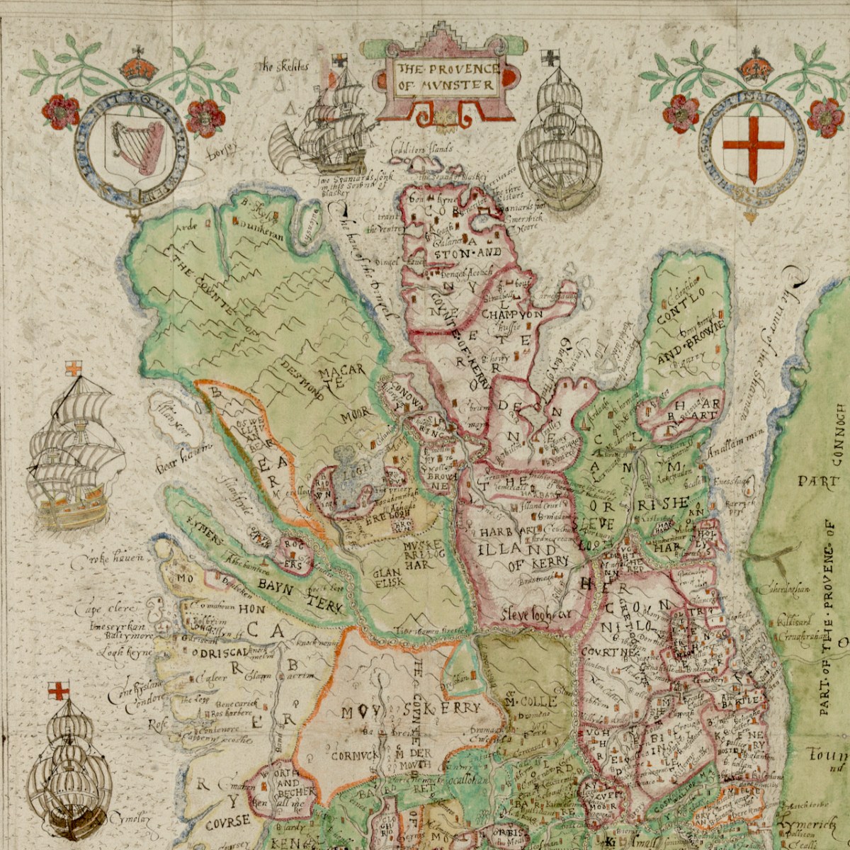
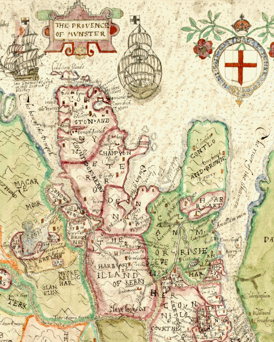
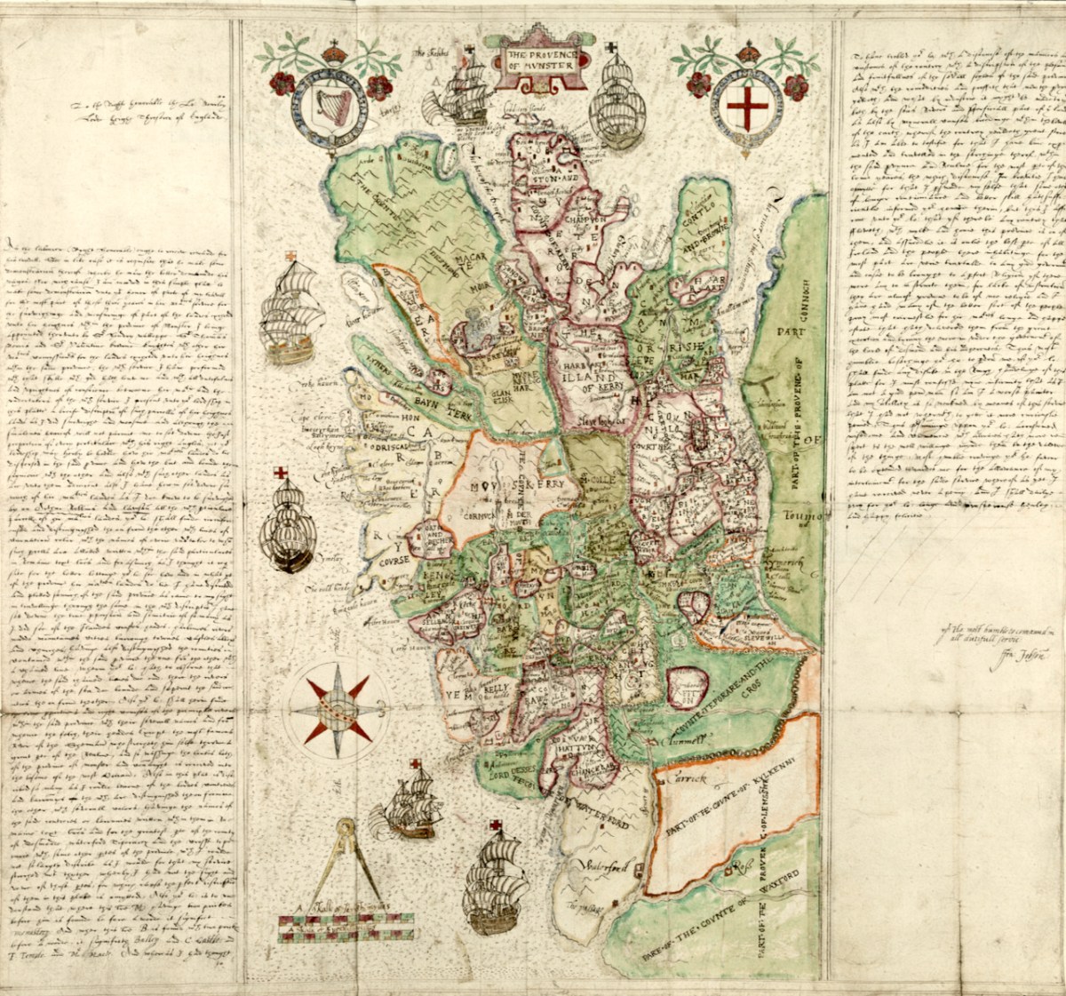
Munster in this map refers to the counties of Waterford, Cork, Kerry and Limerick, rather than the present-day province which also includes Tipperary and Clare. Let’s take a closer look now at some more elements of the map, starting with the section on the counties of Cork and Kerry. Two peninsulas (yes – only two!) are clearly delineated, surrounded by galleons. Note the two crests, one with a harp and the other with the English cross of St George, both bearing the regal motto of Honi Soit Qui Mal Y Pense.
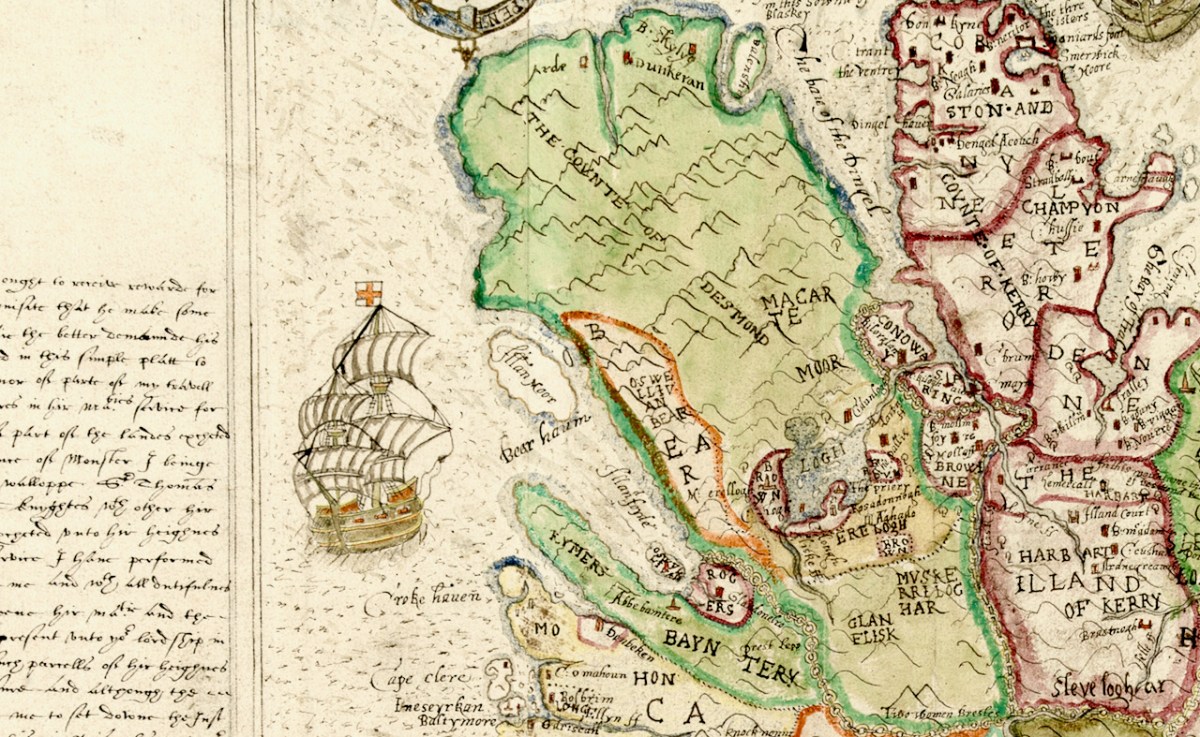
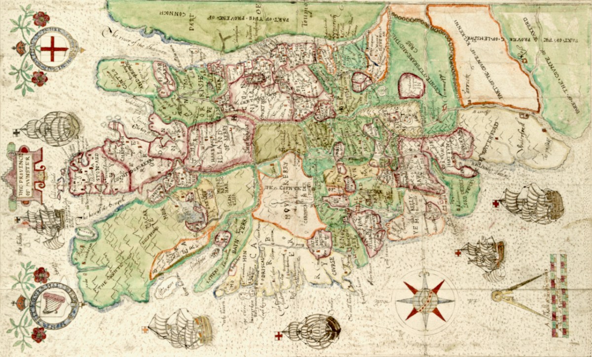
Honing in to take a closer look at the green area (below) labelled the Counte (County) of Desmond we see that the principal families names are Macarte Moor (McCarthy Mór)), who were the overlords of West Cork, and O’Swellivan Bear (O’Sullivan Bear) on the south coast. Below is Donal Cam O’Sullivan Beare – the very man named on the map – read more about him in An Excursion to Dunboy.
Bere Island is Illan Moor (Illaun Mór, which is its traditional name – Large Island – as it is, in fact, Ireland’s largest island). Whiddy Island is called Illanfoyde, and is assigned to the O’Sullivans. All around Bantry is assigned to Rogers, a completely unfamiliar name, although one of our commentators last week noted that there is a strand there called Roger’s Strand!
That whole green area is odd, though, isn’t it? In fact, the Beara and Iveragh Peninsulas are shown as one large landmass, with the Beara marked off by an orange line. Here is the surest evidence we have that this map was not drawn on the ground (or by sea) using actual observations and measurements. The coasts and hinterland of both these peninsulas must have presented formidable obstacles to cartography and reminds us that mapping was a dangerous profession in Elizabethan Ireland.
The dangers are starkly revealed in an account by the Attorney General who related that Richard Bartlett, ablest of all the Queen’s Anglo-Irish cartographers, was beheaded in Donegal in 1609 “because they would not have their country discovered”.
And if it wasn’t the natives, then it was the arduous work of surveying these wild lands that challenged the map makers. This was highlighted by the story of Robert Lythe, an English military engineer who almost went blind and lame while serving in Ireland from 1567 to 1571.
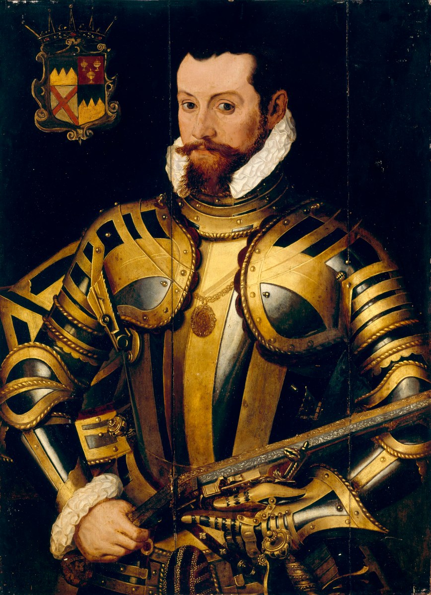
Dingle (in red), however, is a different matter – it has assumed outsize proportions, probably an indication of its importance in the Desmond Rebellions. There are many more place names on it than there are on the green mass. Ventry and Smerwick Harbours are indicated since both were important sites of resistance in the Desmond Rebellions – the barbarous massacre of Spanish and Italian allies at Smerwick was one of the decisive acts in the war, and involved such luminaries on the British side as Black Tom Butler, Earl of Ormond (below), Walter Raleigh and Edmund Spenser. Ventry was where the English troops entered the peninsula.
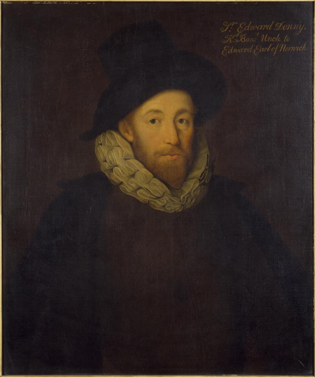
The Bay of Tralee is noted and the area around it is labelled DENE – this refers to the lands granted to Sir Edward Denny (below). I have written about the extraordinary story of the Dennys and their tenure in Tralee – a story that culminated in Ireland’s Newest Stained Glass Window. And by the way – can you see Sliabh Luacra at the bottom of this section – the home of a distinctive tradition in Irish music.
Whew – better end there for today. As you can see. we have barely scratched the surface of what can be gleaned from this map. Perhaps we will revisit it in a future post – but for now I leave you with the tip of the Dingle Peninsula, slightly expanded from the lead image, so you can try your own hand at making out what an Elizabethan planter might have been vitally interested in.
I am grateful indeed to Michelle Agar, Cataloguer, Digital Collections, at the Library of Trinity College Dublin, who gave permission to feature the map from the Hardiman collection in this blog. Also to the kind office of Dr Áine Madden, Communications and Engagement Coordinator with the Digital Repository of Ireland at the Royal Irish Academy. The complete citation for the map is as follows: Jobson, Francis, & Manuscripts & Archives Research Library, Trinity College Dublin. (2021) The Province of Munster, Digital Repository of Ireland [Distributor], Trinity College Dublin, the University of Dublin [Depositing Institution], https://doi.org/10.7486/DRI.rb69b272p
*I am also grateful to the British National Portrait Gallery, who provide an easy method to use images from their collection under license, for purposes such as this non-commercial blog
The sixteenth century was a desperate time in Munster. Two successive Desmond Rebellions (read about them here and here) had resulted in a devastated countryside where, according to the Annals of the Four Masters the lowing of a cow, or the whistle of the ploughboy, could scarcely be heard from Dunquinn to Cashel in Munster. The power of the FitzGeralds, Lords of Desmond, and their allies among the Gaelic chieftains, had been broken.
The Tudor government determined that what was needed was a complete colonising effort, that would bring the benefits of English civilisation to the lawless Irish. William Cecil, Lord Burleigh, set about planning the Plantation of Munster.
In June 1584, a commission surveyed southwest Munster, mapping out the lands belonging to a swathe of Irish lords associated with the rebellion, which were then granted to a small group of wealthy English Undertakers.
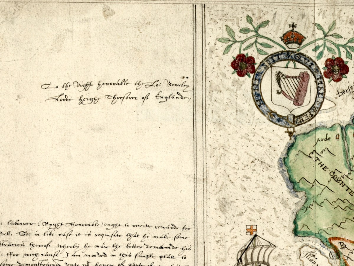
Jobson’s dedication – to the Right Honourable the Lord Burleigh, Lord High Treasurer of England
What a project like this needed, of course, was an accurate map and they were hard to come by in medieval Ireland. Francis Jobson, a free-lance cartographer, set himself the task of producing such a map, and in 1589 he inscribed this one, The Province of Munster Map (the subject of this post), to Cecil. The original is in the library of Trinity College and I have been given permission to use it in our blog (see end of post for complete citation.)
Jobson’s signature
George Carew, one of the primary planters, the first President of Munster, was a man who asserted he had an ancestral claim to large chunks of Munster. To back up his various claims, he collected papers and maps in support of the colonising efforts, and these maps later found their way to Trinity College in Dublin, to form part of a collection called the Hardiman Atlas, after the nineteenth century librarian who recognised what they were and bound them together.
The Province of Munster Map is but one of this collection, now digitised and available for viewing in theDigital Repository of Ireland. And an excellent job they have done of it – the high-resolution image is so clear that it allows us to zoom in and see lots of detail. Here is the complete map.
The first thing that strikes the modern viewer is that Ireland is on its back – that is, instead of north being at the top, west is. This wasn’t unusual for the time. JH Andrews, one of Ireland’s foremost cartographic historians explains it thus, With east at the bottom, Dublin, the Englishman’s point of entry to Ireland, is the point on the map nearest him. To provide a more normal orientation, I have turned the map sideways, below, so you can assess how accurate it is.
The task facing Jobson was to provide as clear information as possible for the colonising effort. Any kinds of fortifications, where the Irish could defend their territory, were important, as were transportation corridors, by sea, river or land, as well as barriers to movement, such as mountains or dense forests. Control of the fisheries had generated great wealth for the Irish chieftains so it was important to have details of coastal areas.
Speaking of Jobson’s Map of Ulster, Annaleigh Margey says
His maps are crucial to our understanding of England’s changing relationship with Ulster at the end of the sixteenth century. As the Nine Years’ War began, Jobson provided representations of the Gaelic lordships in Ulster, but also imposed England’s vision for the creation of a new county system onto the provincial landscape. In Jobson’s 1598 map, now at Trinity College, Dublin (p. 42), this framing of the new political geography is obvious. Throughout Ulster, the various Gaelic lordships are denoted by the lord’s name and a line defining their boundary. Settlements such as castles and churches that could be integrated into English settlement plans are displayed by small replicas in red across the map.
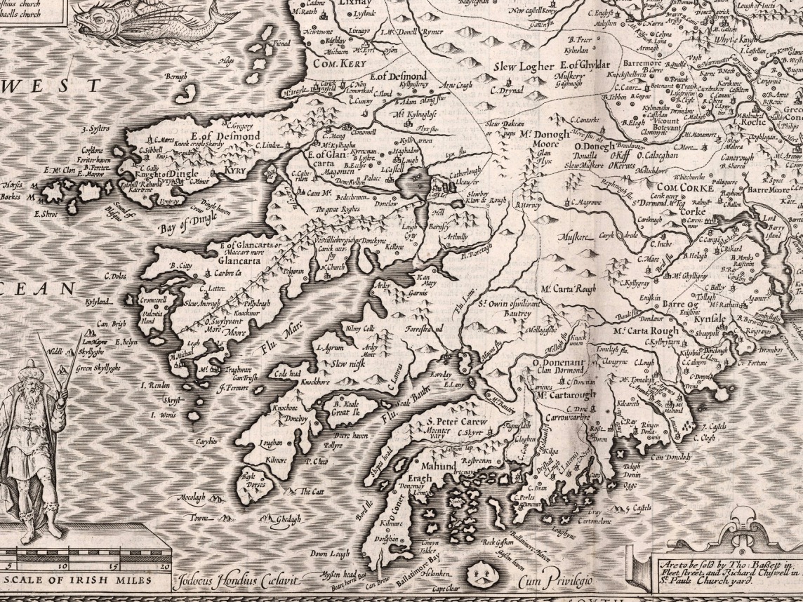
She could well have been speaking of the Map of Munster. The principal families and their territories are all presented, as well as their main castles. While West Cork is not rendered accurately, we can see what Jobson felt was important to include. The O’Mahonys (Mahound) are there and the castles shown for them are Dunbeacon, Rossbrin and Ardintenant, which is labelled C o mahoun, as befits the castle of the Chief (see my post on Ardintenant here). The whole of Ivaha (now the Mizen Peninsula) is assigned to Mohon (spelling was approximate in these maps) and Crookhaven is indicated, probably because it is an excellent harbour.
The O’Driscolls are shown at Baltymore, with Castles also on Sherkin (Ineseyrkan) and Cape Clere. The Ilen River is shown as the Ellyn ff (ff or flu is often found on old maps to designate a river). Interestingly, the whole of the Sheep’s Head has no detail on it and only one word – Rymers. The O’Dalys were the traditional bards of several Irish families and they had their bardic school near Kilcrohane – they are The Rymers! The Abbey in Bantry is noted (in fact it was a Franciscan Friary) – and even Priest’s Leap is on this map. Once the only land route between Bantry and Kenmare, it is now a steep, treacherous and extremely scenic back road.
We have only just started looking at this map. The next post will continue the journey. Meanwhile – have a look yourself and see what you can see. I have lots of questions about it – for example, about the scale that Jobson uses (above) – I am hoping our readers might have some answers!
I am grateful indeed to Michelle Agar, Cataloguer, Digital Collections, at the Library of Trinity College Dublin, who gave permission to feature the map from the Hardiman collection in this blog. Also to the kind office of Dr Áine Madden, Communications and Engagement Coordinator with the Digital Repository of Ireland at the Royal Irish Academy. The complete citation for the map is as follows: Jobson, Francis, & Manuscripts & Archives Research Library, Trinity College Dublin. (2021) The Province of Munster, Digital Repository of Ireland [Distributor], Trinity College Dublin, the University of Dublin [Depositing Institution], https://doi.org/10.7486/DRI.rb69b272p
I am also grateful to the British National Portrait Gallery, who provide an easy method to use images from their collection under license, for purposes such as this non-commercial blog
John Speed was one of the greatest of Britain’s map-makers, but it is unclear how much actual original cartography he did. Much of the information in his maps appears to be based on Mercator’s maps, which we featured in Mapping West Cork, Part 1. What does appear to be original, as there are no previous records of them, are the city maps, so we can be reasonably sure that these were done from his own calculations – laid out by paces rather than by measuring implements.
Who was John Speed? Born in 1551, he trained as a tailor but his passion was for maps and he finally worked his way into a full time position as a historian and geographer, even being allocated a room for his research by Queen Elizabeth I.
His magnum opus was The Theatre of the Empire of Great Britaine, published in 1611 and 12. This marks them as later than Mercator’s maps, but earlier than Joan Blaeu’s (see Part 1).They were also drawn with the collaboration of Iodicus Hondius, who had drawn Mercator’s, which also explains the similarities to Mercator’s maps.
The edition of Speed’s atlas that is most often referenced is the one published in 1676, and that is the one that the wonderful David Rumsey acquired and uploaded to his map collection site. Until I read the fine print, I hadn’t realised that the maps in fact dated to 1611/12 and therefore were older than the Blaeu atlas.
This is the period immediately following the Battle of Kinsale in 1603, which marked the decisive end to the Nine Year’s War, and to the old Gaelic way of life. The maps were also made in the period after the failed Desmond Rebellions of 1569–1573 and 1579–1583. They still name the great Irish families rather than the English planters who would so totally supplant them over the course of the next century. In this regard, it is an important record of what was happening on the ground in 1611.
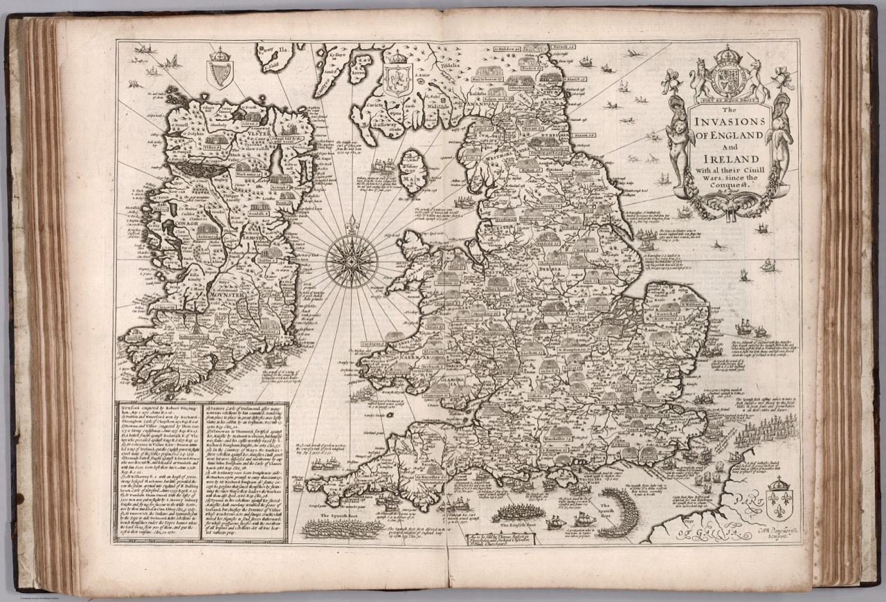
Along with his Atlas he produced a work that combined history and geography – the Invasions of England and Ireland, in 1601 and 1627. He was, of course, a devoted subject of the Queen (‘her sacred maiestie’) and his political opinions tended to the conservative, if not puritantinical.
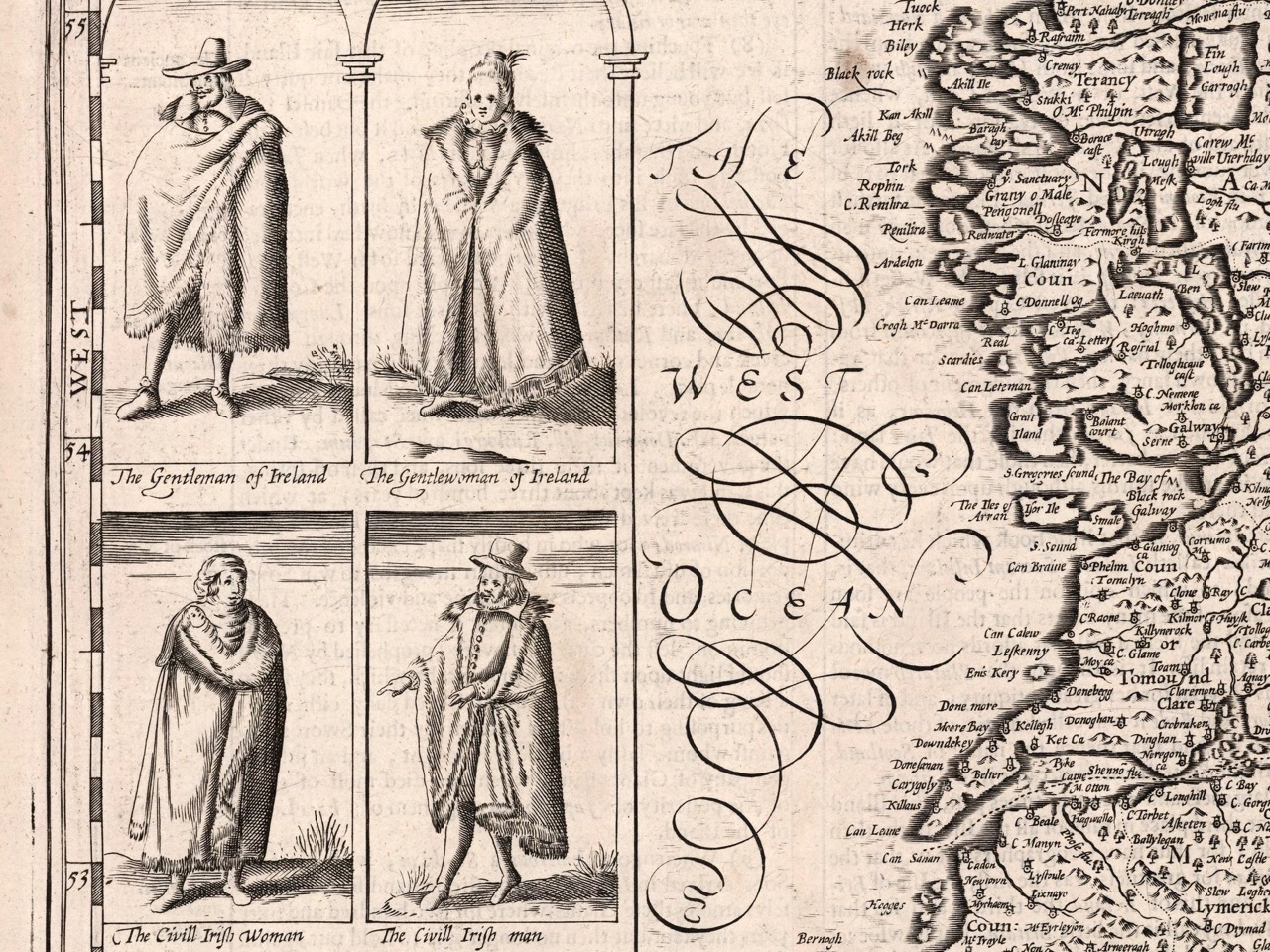
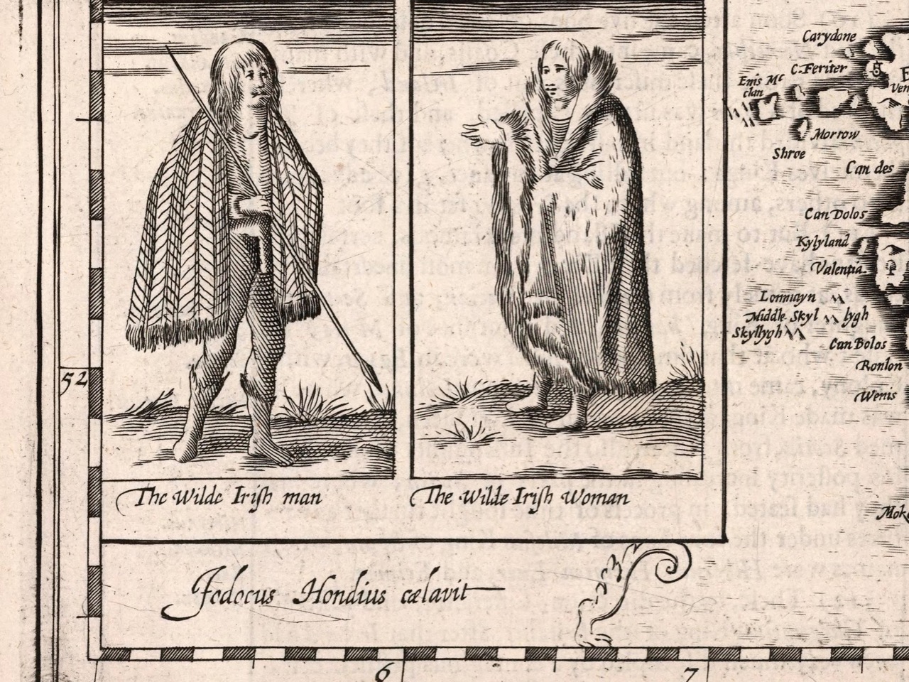
This map is accompanied by the history of invasions, with suitable illustrations. I am particularly taken with the depiction of ‘Desmond beheded’
True to his day, he depicted the Irish quite differently from the British – the lowest grade of English person was the Countryman or Country woman, whereas in Ireland it was the Wilde Man or Woman.
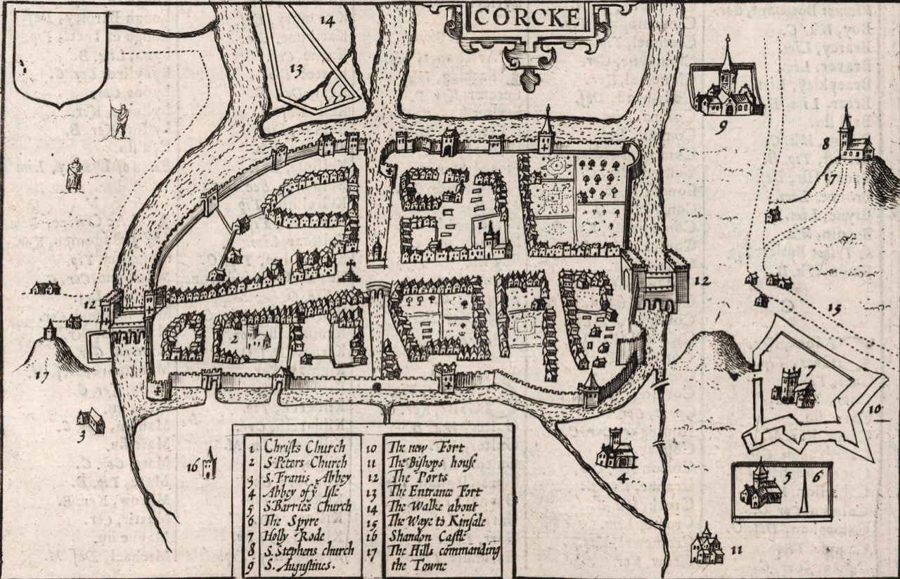
The city maps were all new and it seems that Speed, with one of his sons, actually travelled to the cities he includes in his atlas and paced out the distances, drawing the maps based on these calculations. They are a unique and invaluable record of a time when Ireland had walled cities, especially given that so few intact stretches of those walls remain. (We’ve visited some impressive remains, though – see Youghal’s Walls and our post on the walled town of Fethard.)
The Dublin map is from a later edition
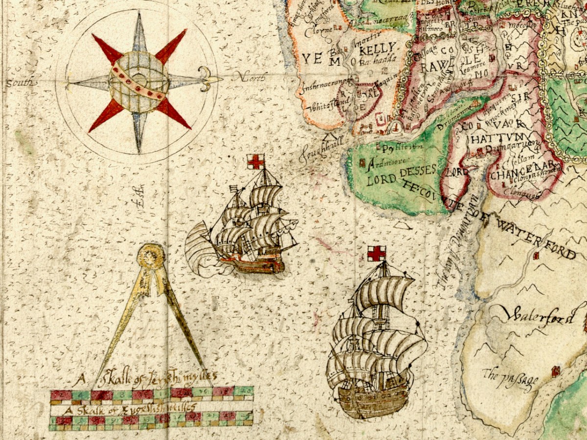
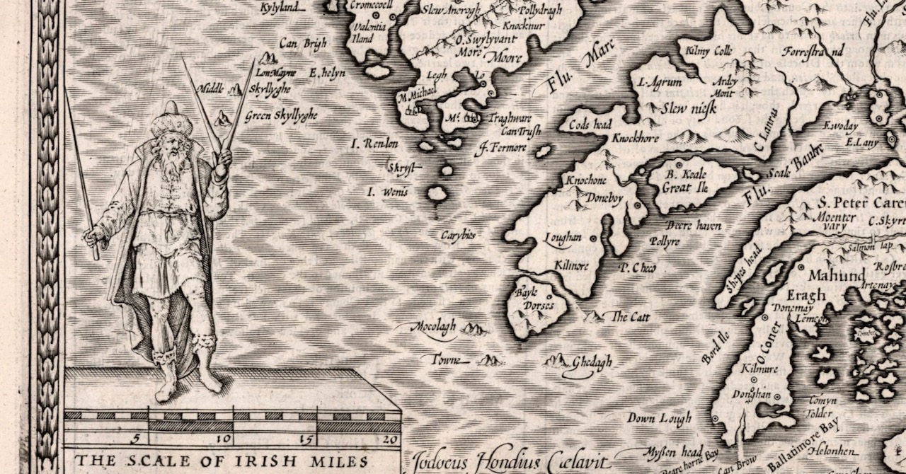
The actual physical depiction of the land is recognisably based on the Mercator map but there is more information now about locations and families. I was delighted to see Rossbrin show up (Roßbrenon) along with Ardintenant (Artenay), since it is this castle that we look across to from our home. Mizen Head and Brow Head are both marked, and the Sheep’s Head is also noted as Moentervary (Muintir Bheara is the Irish designation for that Peninsula).
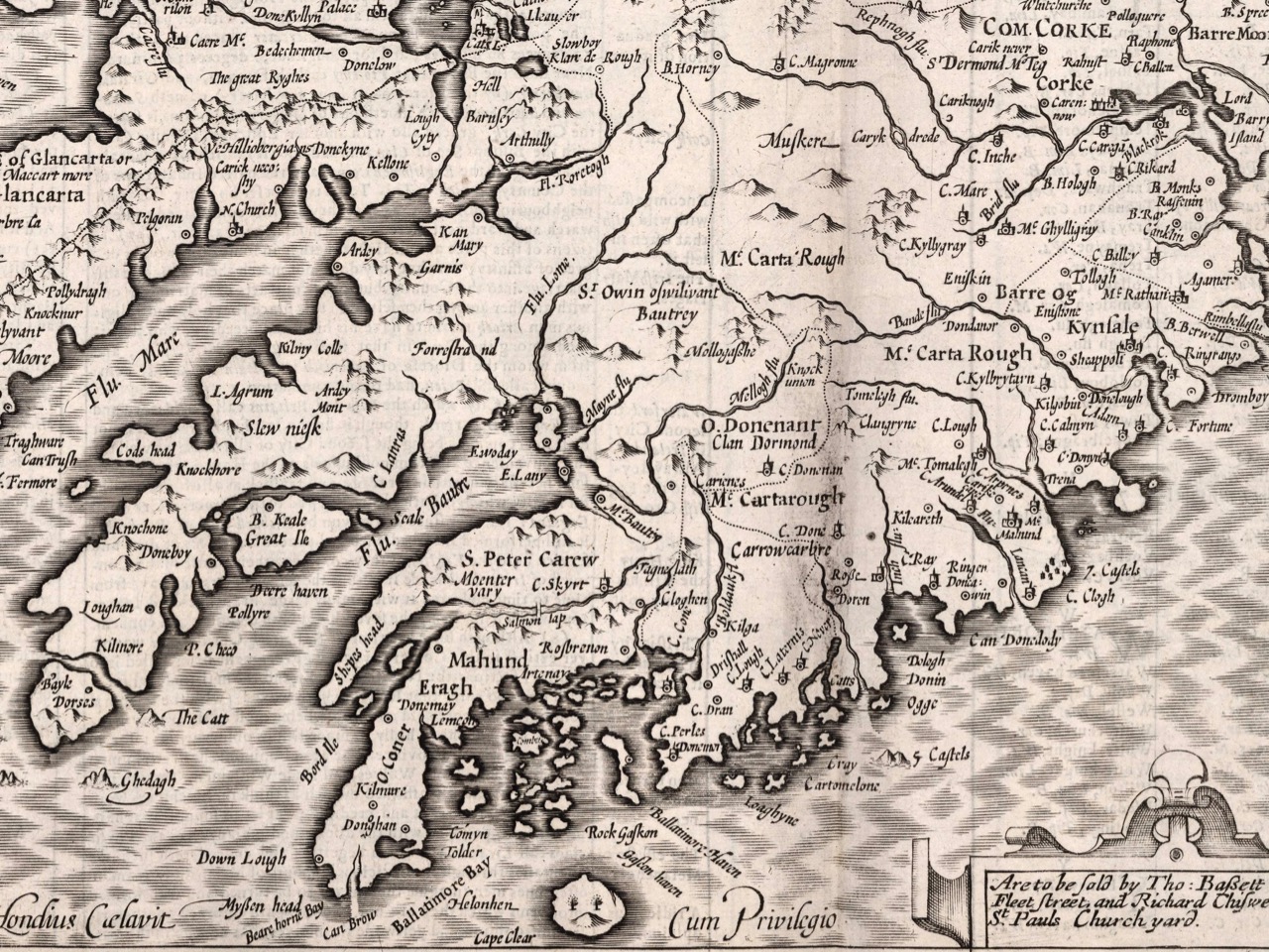
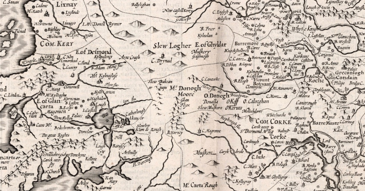
Besides the O’Mahonys, the O’Driscolls, the McCarthys, the O’Donovans, Sir Peter Carew occupies a chunk of land. Someday I will write about his claim to that land and the lengths he went to to secure the deeds to it. But perhaps I shouldn’t be too exclusive to West Cork: below is a section of North Cork and part of Kerry in 1612. What can you see?
Maps drawn by a colonising power, have an agenda far beyond simply charting the territory. John Speed’s became the defining maps of the expanding British Empire during the seventeenth century and indeed they influenced British people’s perceptions of the world until well into the eighteenth. For us in Ireland, and in West Cork, they are an invaluable social document.
Welcome to the UCD Library Cultural Heritage Collections blog. Discover and explore the historical treasures housed within our Archives, Special Collections, National Folklore Collection and Digital Library