The more I look into the Church of the Ascension in Timoleague the more fascinating it becomes. In the first post I concentrated on the mosaics and the story of the Maharaja but in this one – a substantial re-working of the original 2016 post – I look mainly at stained glass and architecture.
As we shall see, the windows were produced by the most famous British stained glass artists of their day. Taken as a whole, in fact, the architecture and decoration of this singular church leads us directly to Augustus Pugin, one of the giants of the Victorian Age, and locates it in the highest echelons of the Gothic Revival Movement. This hidden gem is even more of a jewel than I suspected!

A portrait of Pugin in, appropriately, stained glass. This window is in the Pugin-designed Catholic church in Tagoat, Co Wexford and is by George Walsh
Who was Augustus Pugin? Born in 1812, son of a French emigré draughtsman and an English mother, Pugin trained in his father’s workshop, becoming proficient in design and drafting by aged 9. Conversion to Catholicism and a visit to Nuremberg in Germany convinced him that the greatest expression of church architecture was High Gothic and he set about challenging, and ultimately revolutionising, the prevailing design norms of the Victorian period. He was incredibly prolific and influential, such that today when we think about Victorian architecture and gothic revival, we are really thinking about the work of Augustus Pugin – even though he died in 1852 at the early age of 40.

The signature of the Warrington Stained Glass Company on the East Window, dated to 1865
Pugin designed several churches in Ireland (mostly Catholic), especially in Wexford, where you can follow the ‘Pugin Trail’. (I don’t know who wrote the Wexford Pugin Trail brochure, but it is one of the best explanations of his style and influence that I have read.) While he did NOT design the Church of the Ascension, his influence is everywhere in evidence, along with the use of some of his favourite suppliers – Minton for the mosaics and encaustic tiles and Warrington for stained glass. Later windows by Lavers Westlake and Co, Mayer of Munich and London, and Clayton and Bell follow the traditional patterns for stained glass and add immeasurably to the beauty and interest of the interior.

Hallmarks of gothic revival: a beautiful hammer-beam ceiling, tall pointed windows with simple Y tracery, everything to lead the eye upwards
The art of making stained glass in the medieval style had been lost and during the 18th century colour was mostly painted directly on the glass using an enamel technique. But part of the gothic revival ethic was to base manufacturing technology as closely as possible on the original so there was also a re-discovering of real stained glass processes where the colour was fired directly into the material and sections of glass were separated by lead. This art was revived in the 19th century by artists and craftspeople who studied medieval glass and learned through trial and error how to make it again.

Window by Thomas Willement, originally in the east wall before the chancel was added
One of the first to experiment was Thomas Willement, known as the Father of Victorian Glass, and when the church was completed in 1811, it contained several of his windows. The things is, these were quite plain, as befitted the Church of Ireland ethos of the time, where the emphasis was on an unadorned interior that did not distract from concentration on the Word. Nevertheless, we see the start of a pattern here of ordering stained glass from the foremost British manufacturers of the time. The Willement windows now on the west (entrance) wall were originally in the east wall but were moved when the church was renovated in 1865. They consist of diamond-shaped quarry glass with a decorative border pattern. A third Willement window is situated in the North Transept beside the organ. I can find only one other documented Willement window in Ireland, in Sligo.

John Henry Newman (1801 -1890) by Sir John Everett Millais. Newman’s Oxford Movement advocated for the return of ‘Catholic’ beliefs and rituals to the Church of England, paving the way for the changes advocated by the Cambridge Camden Society. Newman converted to Catholicism, became a Cardinal, and was recently canonised
The renovations of 1865, which added a chancel, vestry and south transept were all in line with the new thinking about church architecture and liturgy promoted by Newman, Pugin and the Cambridge Camden Society. The emphasis was now to be on the Eucharist and the altar, rather than on the pulpit, and this involved adding a chancel to accommodate the altar. God was to be glorified through sumptuous decoration – a radical change in how a church interior should look, and one that did not meet with immediate acceptance among all clergy and parishioners. Regarding that sumptuous decoration – we’ve already looked at the mosaics so let’s turn our attention now to equally arresting figurative stained glass, a departure from the simple and unobtrusive Willement windows.
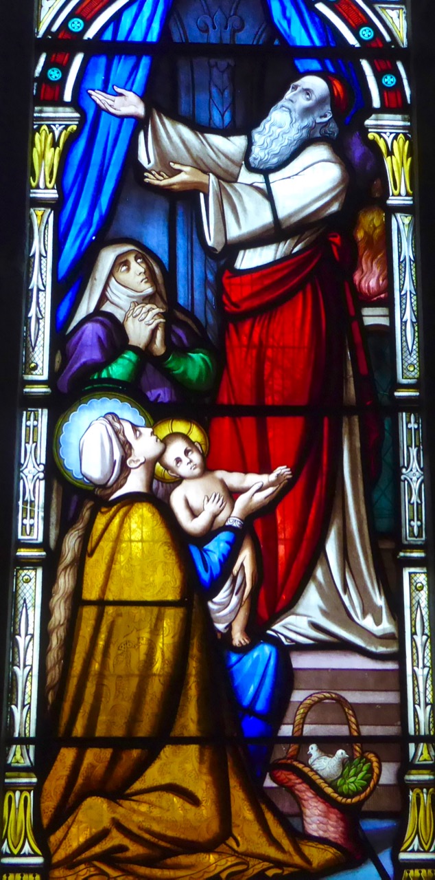
The Presentation, East Window
We’ll start with the East Window, the work of Warrington. William Warrington was one of the leading stained glass artists of his day. There are very few Warrington windows in Ireland (I have found 12 others in Gloine.ie, although that only records Church of Ireland windows) since he was producing windows before the wholesale adoption of stained glass by Irish churches, so the parishioners of the Church of the Ascension were ahead of the curve on this. Like Pugin, Warrington was a student of the gothic style and he strove to reproduce glass work as closely as possible to medieval models. He had trained with his father as a painter of armorial shields, an influence that can be seen in his designs. He wrote a book in 1848 on The History of Stained Glass, but fell afoul of the Cambridge Camden Society (or CCS) who had set themselves up as the arbiters of taste in all things related to church architecture. Partly this was the outcome of class prejudice: the CCS, all university educated men, did not believe that a “mere artisan” should be allowed to have an opinion of what they saw as their own exclusive preserve.

Detail from The Raising of Dorcas, East Window
By any standards, this is a beautifully executed window. According to the Wikipedia article, Warrington’s figurative painting strives towards the Medieval in its forms, which are somewhat elongated and elegant, with simply-painted drapery falling in deep folds in such a way that line and movement is emphasised in the pictorial composition. His painting of the details, particularly of faces, is both masterly and exquisite.

The Raising of Dorcas, East Window. In this story, from the Acts of the Apostles, Peter prays over the dead body of Dorcas, who returns to life
This is all clearly visible in the East Window, a confident set of three lights depicting the Crucifixion in the centre, Raising Dorcas on the left and the Presentation in the Temple on the right. Note the use of heraldic motifs above the main panels, and the tall medieval-style spires of foliage, all typical of Warrington glass.

The crucifixion iconography, unusual for a Church of Ireland church, was all too much for the Bishop of Cloyne when he came to consecrate the new chancel in 1861. Cloyne Cathedral itself was a true medieval building but much simpler in its interior decoration. The Bishop obviously had less sympathy with this new style of highly decorated church interiors and objected in particular to the East window, which he viewed as far too Catholic in its influence. In common with many of his Protestant contemporaries he probably felt that stained glass windows were an unwelcome intrusion into this sacred space, but might have been able to tolerate a Bible scene such as that of the Good Samaritan.

He refused to conduct the consecration unless the window was covered in a cloth. The cloth, apparently stayed up a long time, and when it came down the window continued to attract opprobrium – it was even attacked and broken on at least one occasion! It’s hard now to understand now how such a beautiful piece of devotional art could have inspired an over-the-top reaction like this, but the High Church movement involved such a total transformation of liturgy and architecture that it took many people a long time to adjust to it.

The Sermon on the Mount by Lavers and Westlake
Three sets of two-light windows in the nave are by Lavers, Westlake and Co, yet another of the London-based stained glass firms that responded to the huge demand for gothic-revival glass windows in 19th century Britain. The artist who designed these windows, Nathaniel Westlake, was another scholar of stained glass, publishing a four volume work, A History of Design in Painted Glass, and also a decorative painter of wall and ceiling panels. He was considered one of the leading exponents of stained glass art with a style considered to be Pre-Raphaelite. He worked with William Burges for a while – the one who designed every aspect of St Fin Barre’s Cathedral in Cork – who recommended him to the firm of Lavers and Barraud. In 1868 he became their chief designer and was responsible for much of the success of the firm, which captured a large share of the booming stained glass industry. Unlike Warrington, however, Westlake did not clash with the CCS, probably because his partner, Lavers, was a member of that society.

A detail from the Lavers and Westlake Loaves and Fishes window showing Westlake’s Pre-Raphaelite tendencies
The three windows by Lavers and Westlake are in the nave on the north and south walls and date from 1883. Those on the north wall depicts the Miracle of the Loaves and Fishes and the Sermon on the Mount. That on the south wall is of Jesus Walking on the Water.


Upper, detail from the Loaves and Fishes. Lower, Jesus Walking on the Water
The final window on the south wall is also a two-light one by the firm of Mayer, possibly the busiest stained glass company of all and actually still in business under the name Mayer of Munich. The founder, Franz Mayer, started a company dedicated to “…a combination of fine arts, architecture, sculpture and painting…”. This firm was officially recognised by the Vatican so it was very popular with Catholic churches and there are many examples of Mayer windows throughout Ireland. In 1865 the firm opened a London branch, which supplied this window in 1888.

Christ Healing the Centurion’s Servant, a window by Mayer of Munich and London
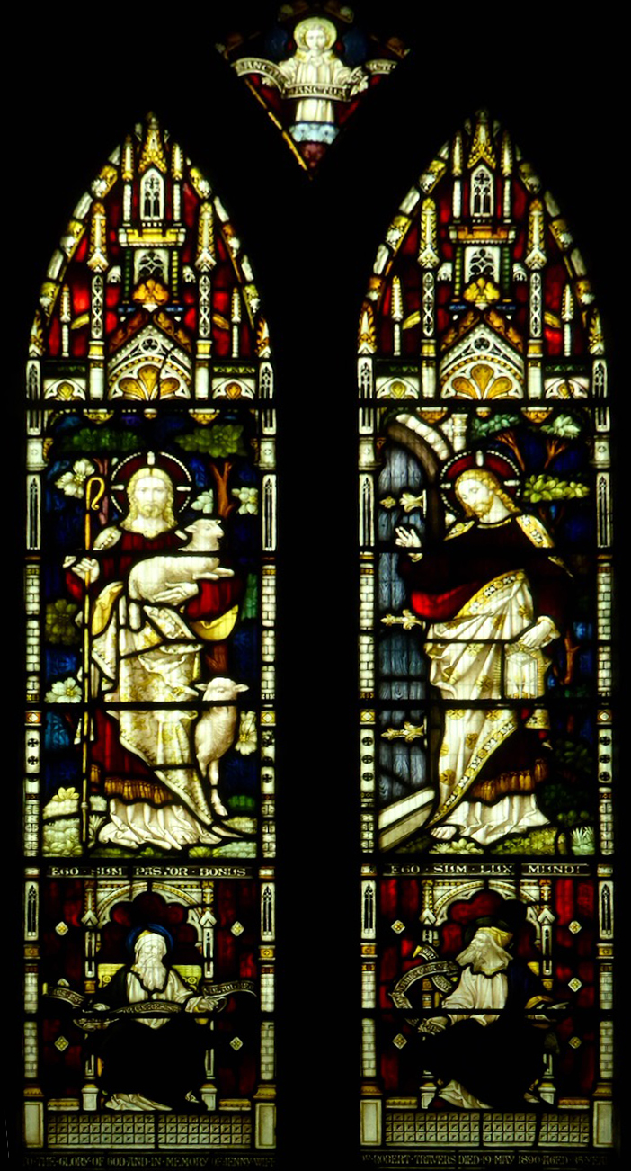
There are three more windows in the south transept, all by the firm of Clayton and Bell, a very productive Victorian stained glass studio. The first is a two light window, dating from 1890 and it depicts Christ as the Good Shepherd and the Light of the World (below). These two images were very much stock-in-trade with all the stained glass studios. The Light of the World was particularly popular – take a look at this post to see just how popular: The First Viral Sensation: How a Pre-Raphaelite Painting Inspired a Generation
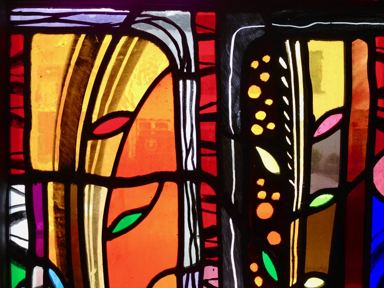
But it’s the other two Clayton and Bell windows, the last to be installed, in 1903, that I find irresistible; indeed they are indeed among my favourite windows anywhere. The artist was George Daniels, whose work is unmistakable. According to David Lawrence:
George Daniels (1854-1940) was perhaps the greatest and most prolifc of all the free-lance cartoonists of the later Gothic Revival period. His style is influenced by late mediaeval and Northern Renaissance sources for both figures and ornament. From around 1880 to 1920, he supplied hundreds of cartoons to the Clayton & Bell studio in London and, from 1895 to 1914, to Mayer & Co. Daniels had a wonderful drawing ability. The vigorous style of his figures and drapery are always particularly characteristic and his compositions are exemplary.*

They illustrate two aspects of Christ, Christ the King (above) and Christ Condemned (below).

There are several more noteworthy features of this fine little church (the pulpit, the carved wooden furniture) but I think I will leave it at that for now. I’ve learned a lot about the Gothic Revival Movement through this exercise, and about some of its chief practitioners. I’ve been struck, as the reader might be, at how British (rather than Irish) the influences are in this church, but that of course was very much a function of the times. At some point I will write about the enormous Catholic church that dominates the village, with a view to showing how the great era of Catholic church building in Ireland finally led to an emphasis on Irish architecture and Irish artisans. For a very brief word on that, you can read my post A Tale of Four Churches.

Timoleague. On the left are the ruins of the medieval friary, the Catholic Church dominates the hilltop, and the Church of the Ascension is behind the green building on the far right
For now, I will leave you with a detail from George Daniel’s magnificent Christ the King, with all that gorgeous golden hair.

*Stained Glass Windows in Six Roman Catholic Churches, County Offaly November 2010
Email link is under 'more' button.