Boyle’s Bealtaine: Rock Art, Ancient Festivals, and Archaeoastronomy

Bealtaine is one of the great ancient festival days, the one that heralds the beginning of the season of fertility in crops and animals. It marks the mid-point between the spring equinox and the summer solstice, making it a cross-quarter day, and this year it fell on May the 5th. For the non-Irish speakers out there, it’s not pronounced bell-tane, but byowl (to rhyme with owl, the bird) – tinnuh – Byowltinnuh. If you’re really keen on getting it right, you can listen to it here.

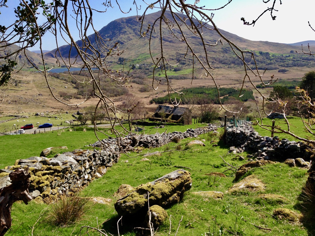
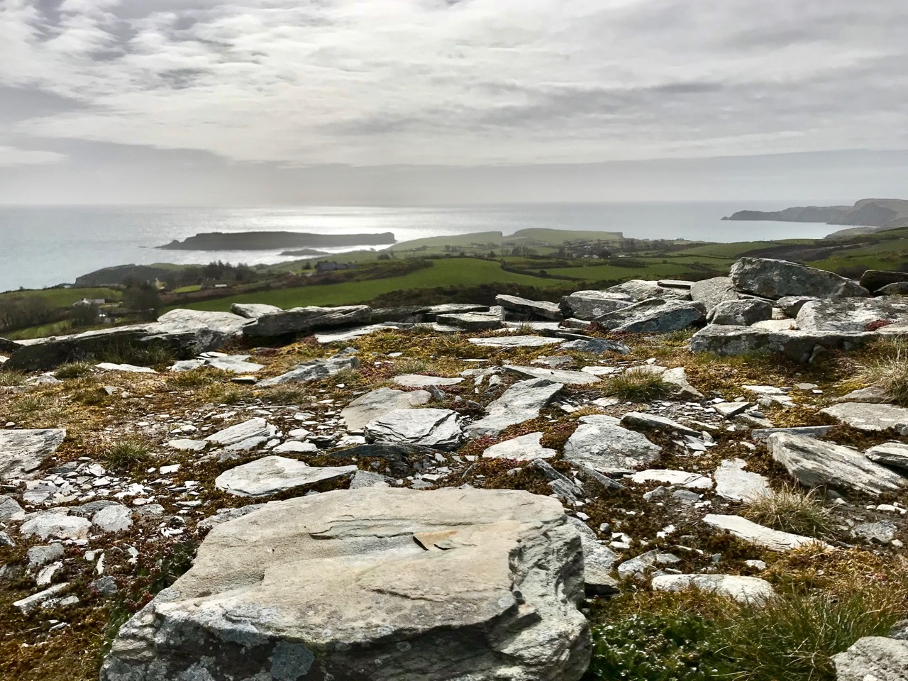
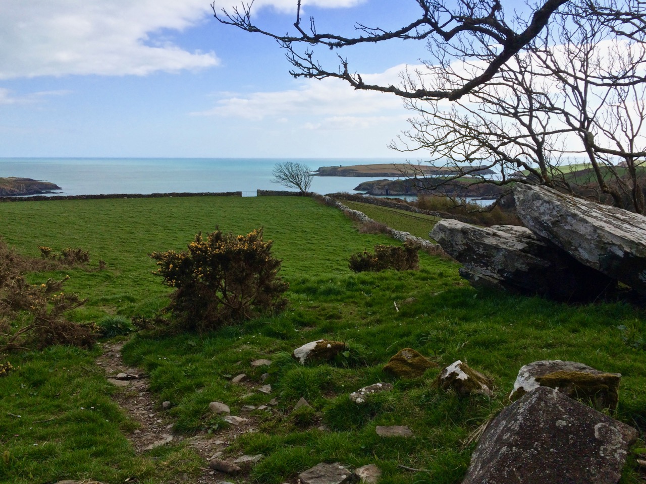
Things did not look promising as we arrived at the Giant’s Grave – cloud and fog

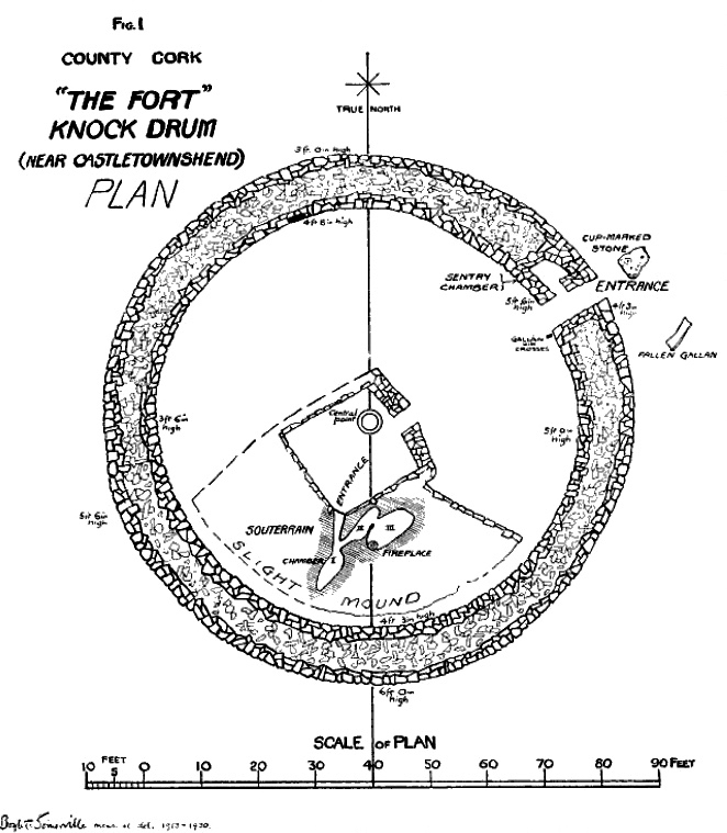
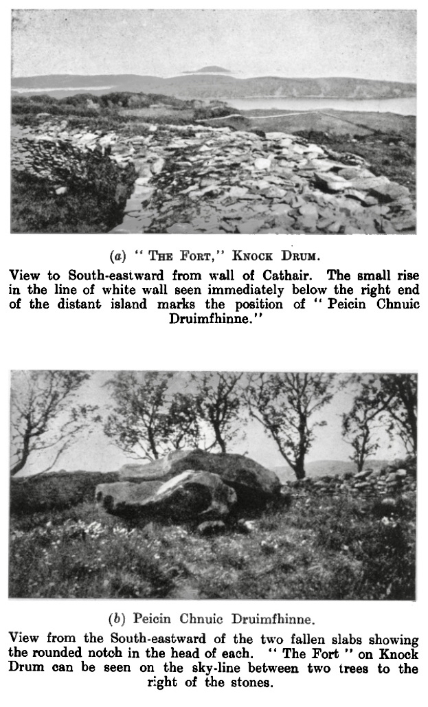
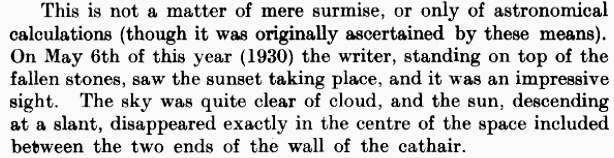
We devoted two posts recently to the subject of Boyle Somerville. The first was a post about his life and his pioneering work on what is now called archaeoastronomy, but which he called the new science of Orientation. The second was about a site that was close to his home in Castletownshend, Knockdrum Fort. In Boyle’s own article on Knockdrum (available online with a JStor subscription), he notes a particular orientation between two fallen galláns (or standing stones) on a slight prominence in the grounds of Drishane House, to Knockdrum Fort itself at sunset on Bealtaine in 1930.

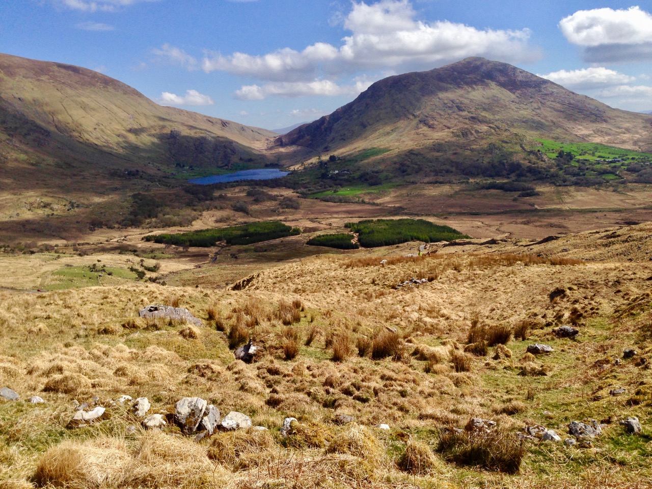
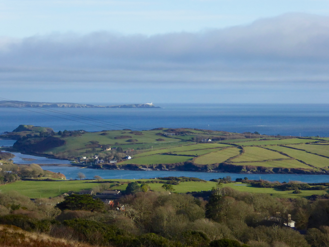
Standing behind the Giant’s Grave, Knockdrum Fort is clearly visible on the horizon

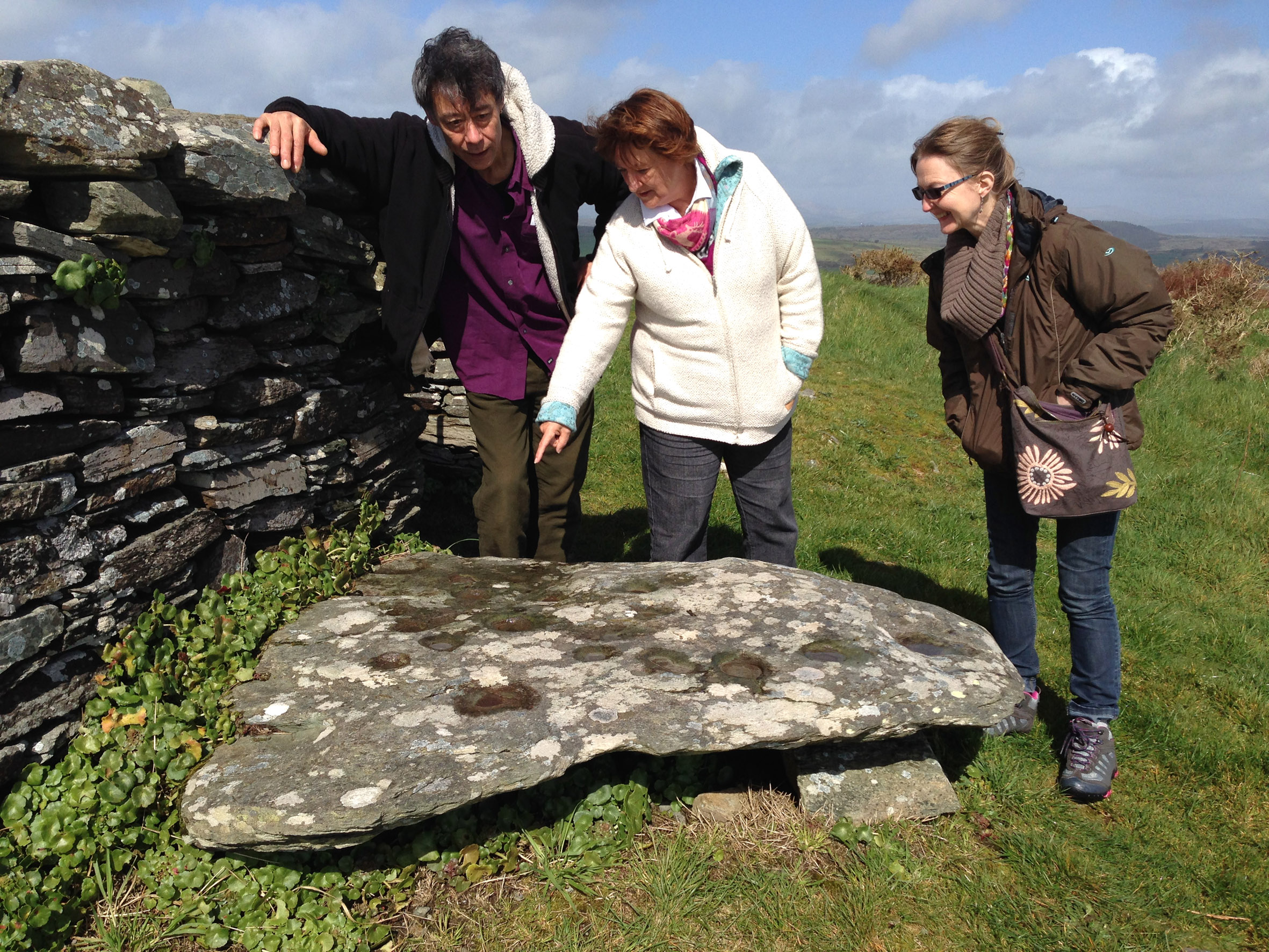
On that day, he states, he stood on the fallen galláns and watched the sun set directly over Knockdrum Fort. Yesterday, we did the same thing. It was a nerve-wracking business as not only cloud cover but a constant drifting fog obscured the hills and we were not hopeful that we would be able to see anything at all. But Boyle was up there, looking down on us, and at the last minute the clouds parted and there was the sun, exactly where he said it would be, angling slowly down to the fort.

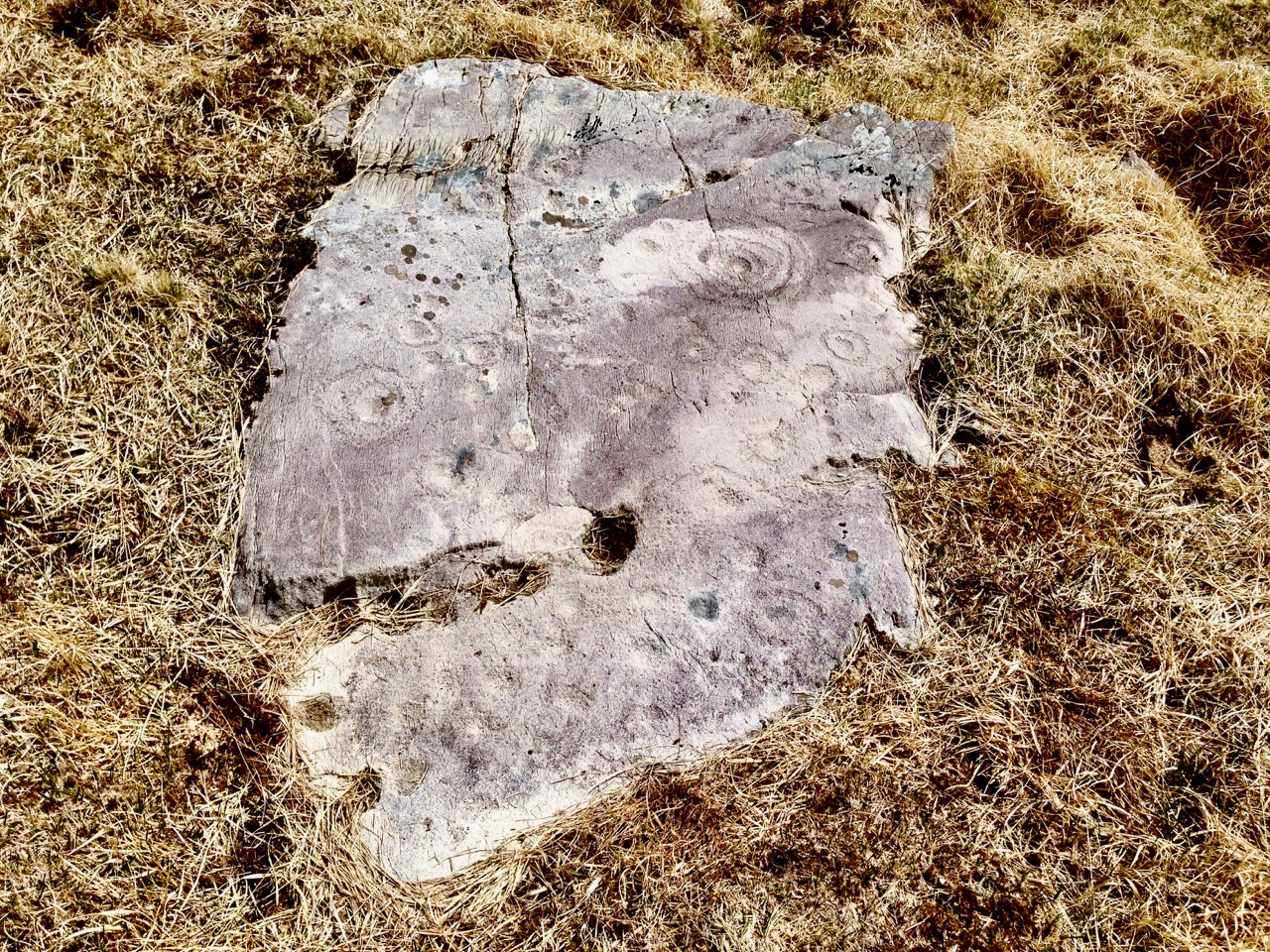
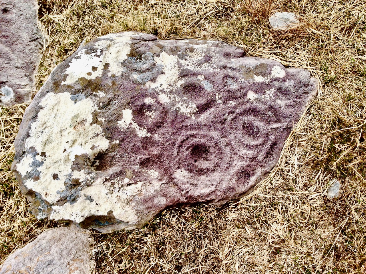
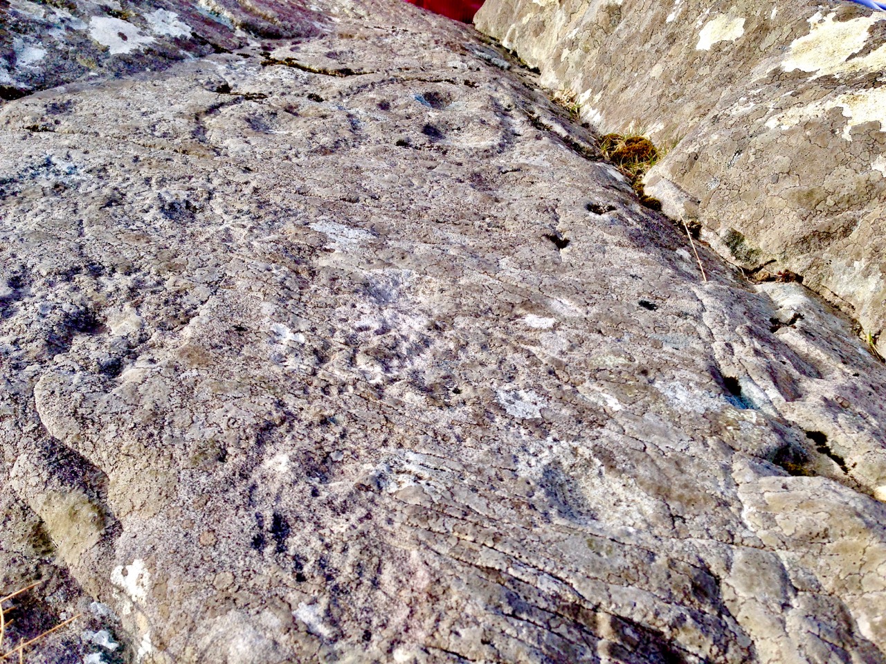
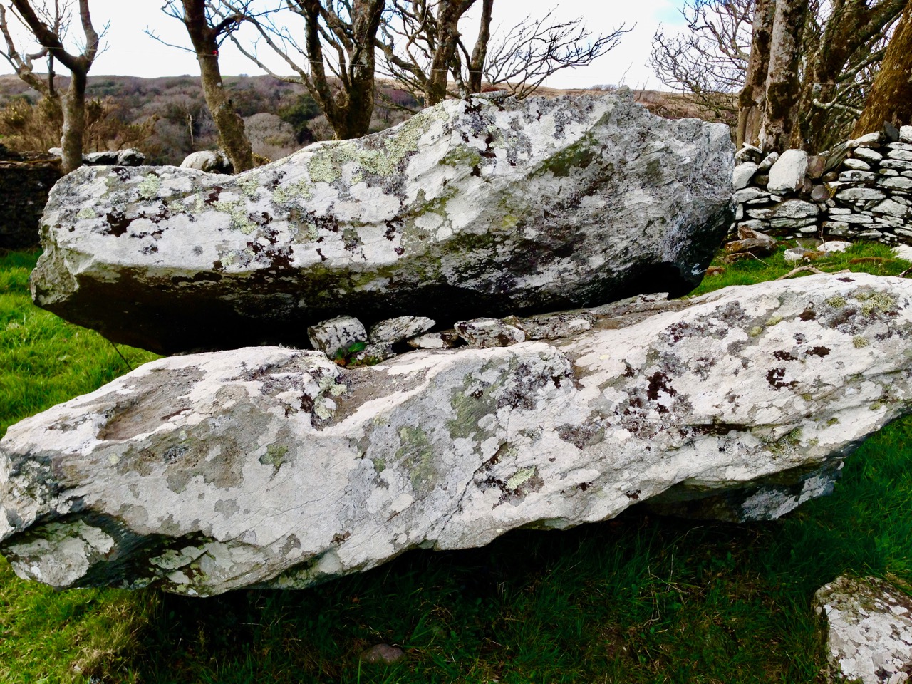
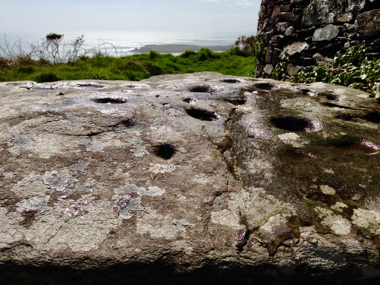
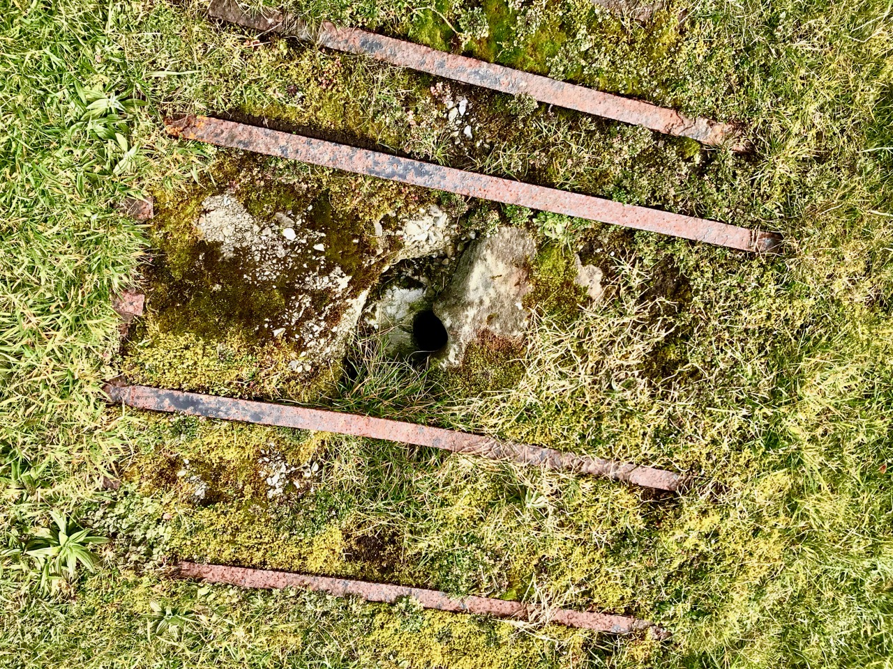
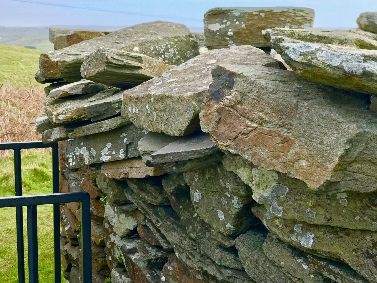
The sun lights up the Giant’s Grave, making the cupmarks on its surface more visible

Watching this descent was a real highlight of my life here in West Cork. First of all, it felt really special to be on the same spot as Boyle Somerville, 88 years later to the day, and verifying his sighting by recording the phenomenon with photographs and video. If anyone else has done it in the intervening years, we can find no record of it, but would love to hear about it.

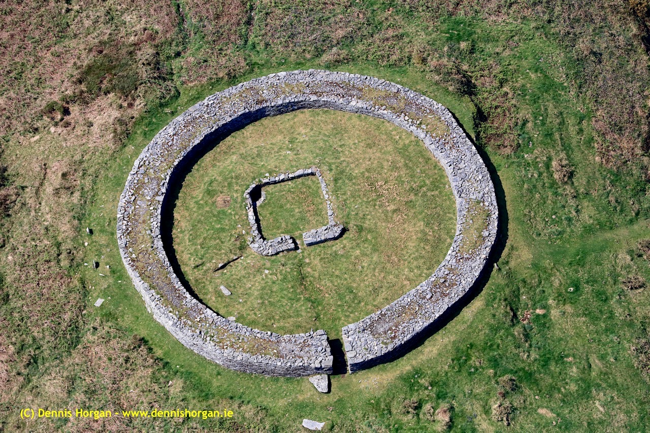
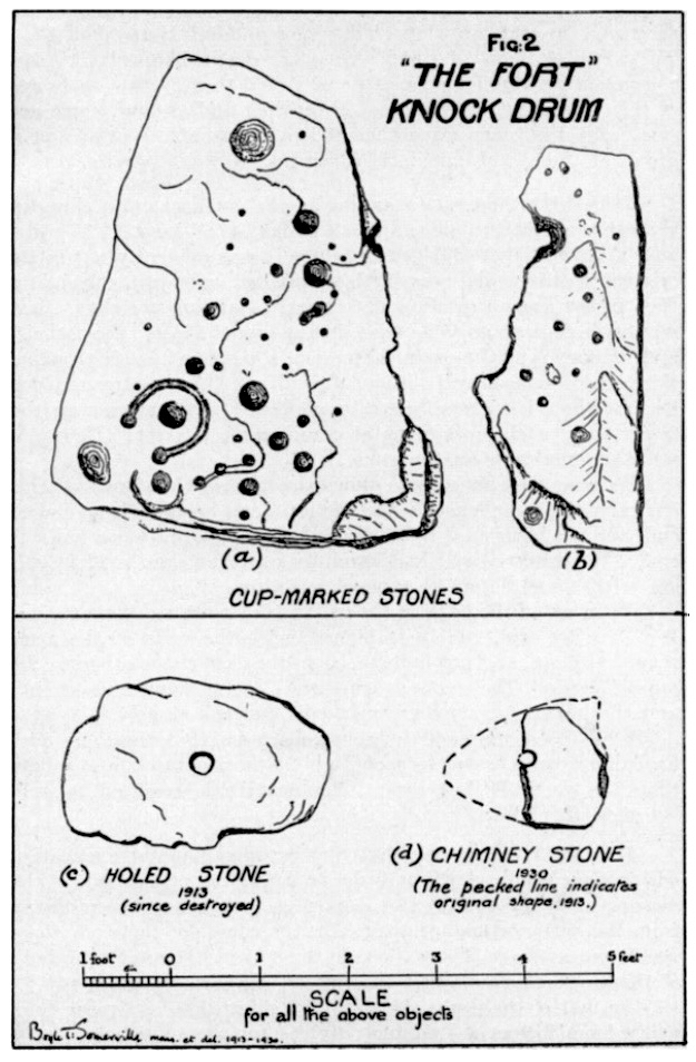
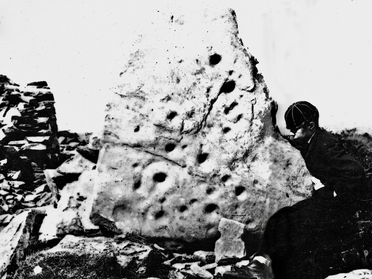
Secondly, this is essentially a rock art story, rather than a stone fort story. As Boyle himself pointed out, the stone fort at Knockdrum is but one piece of evidence of a long and continuous use of this commanding site. There are two carved stones at Knockdrum, one outside the fort with cup-and-ring type carvings, and a cup-marked stone currently lying within it. Look back at Robert’s post to see photographs and drawings of these two stones. These examples of rock art are likely the oldest artefacts on the site, dating to between four and five thousand years ago. There is also a cross-inscribed slab, possibly indicating an Early Medieval use of the site for ecclesiastical purposes. The stone fort itself may have been a relatively recent period of occupation, marking it as the fortified residence of a high-status individual about a thousand years ago. Boyle felt it may even have been used for look-out and defensive purposes in the seventeenth century.


Robert’s 2014 drawing of the surface of the Giant’s Grave capstone with 17 cupmarks

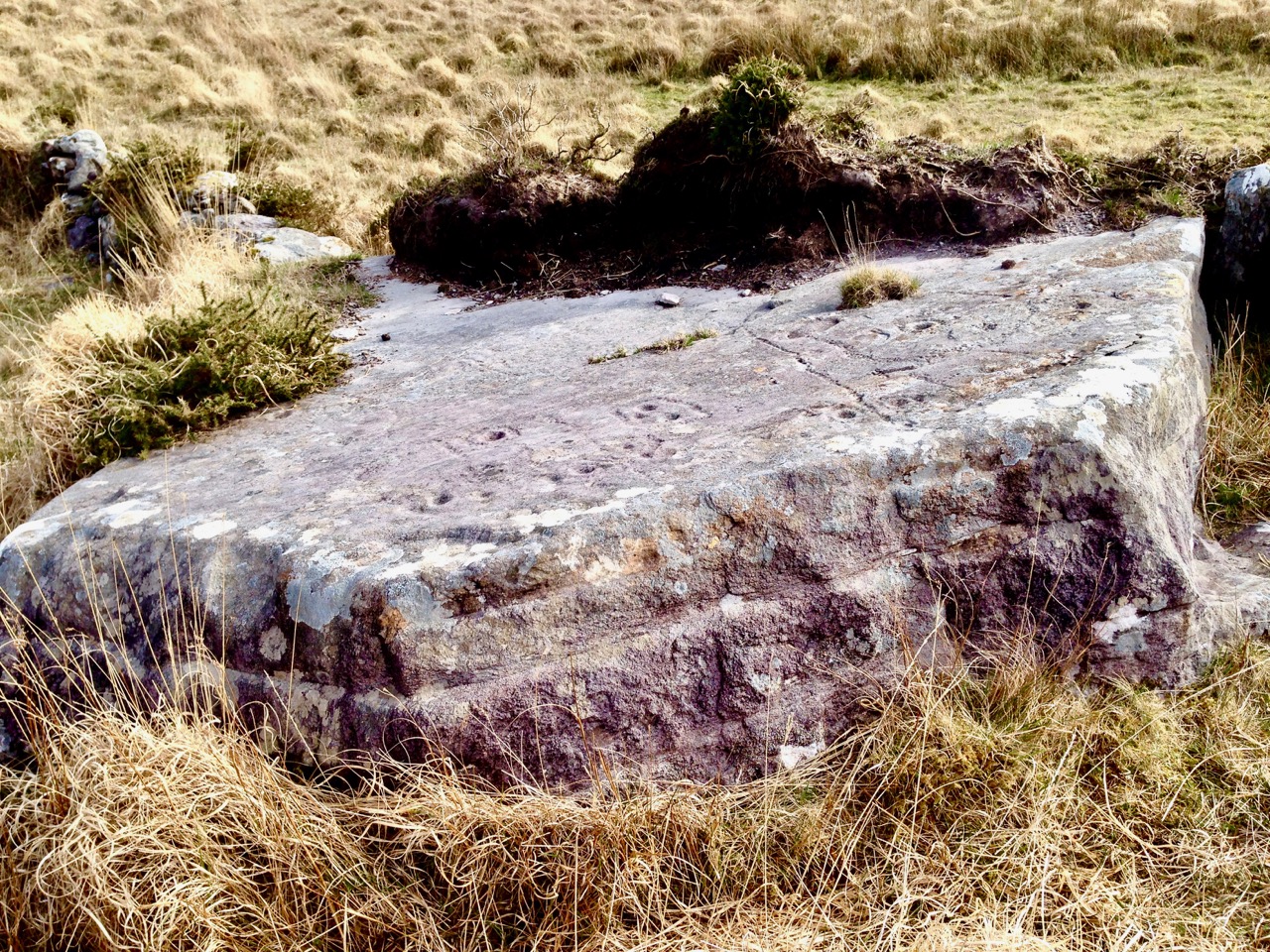
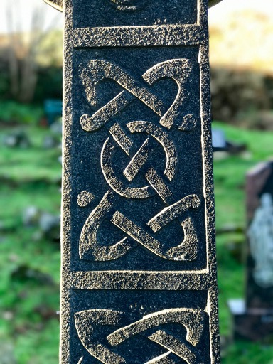
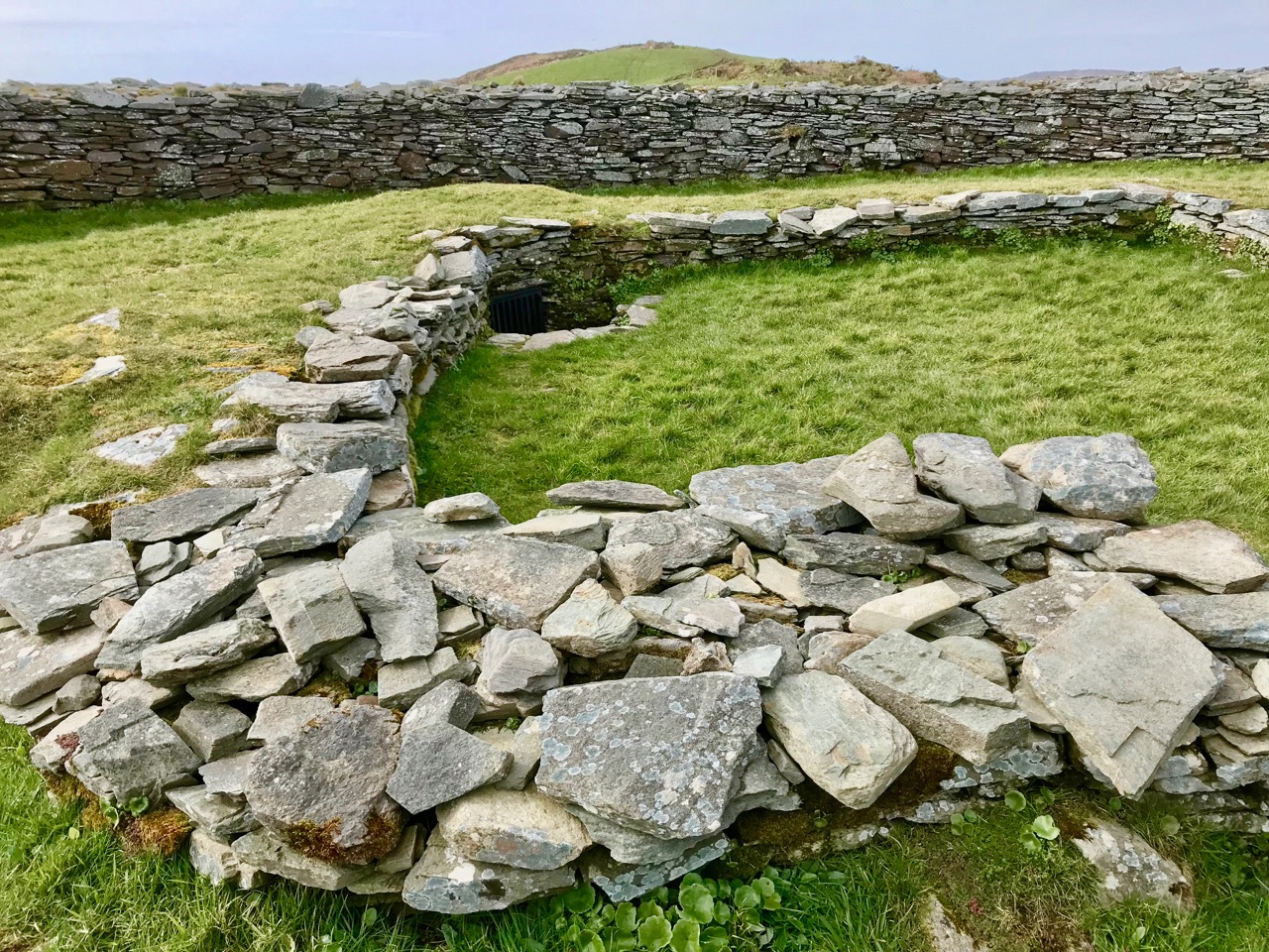
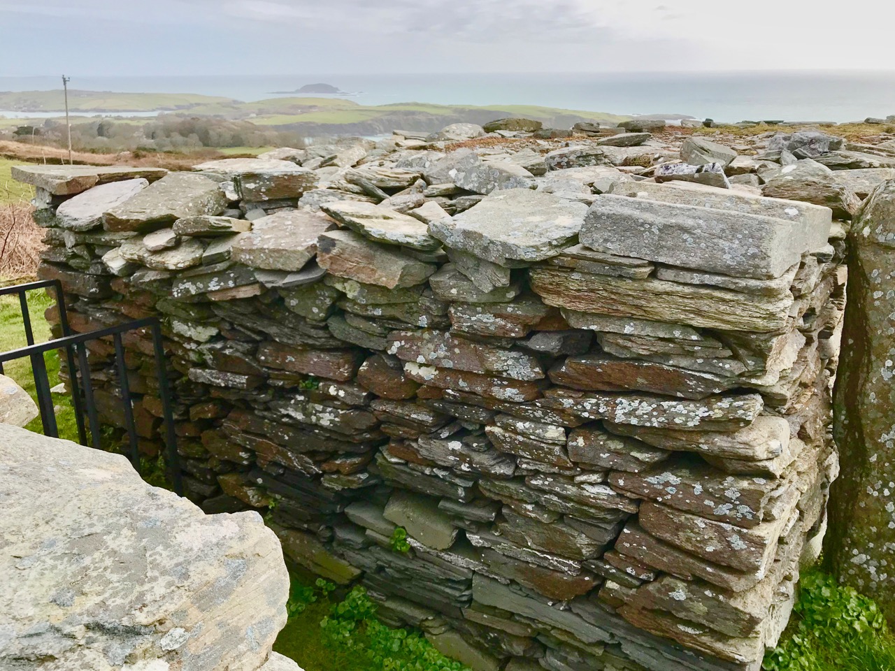
But the fallen galláns, known locally as the Giant’s Grave, also have cupmarks, tying them to the rock art tradition. The upper surface of the top slab has 17 cupmarks. Boyle counted 19 and the National Monuments record has it as 12, showing how difficult it can be to accurately identify man-made marks on a rough and heavily-lichened surface.

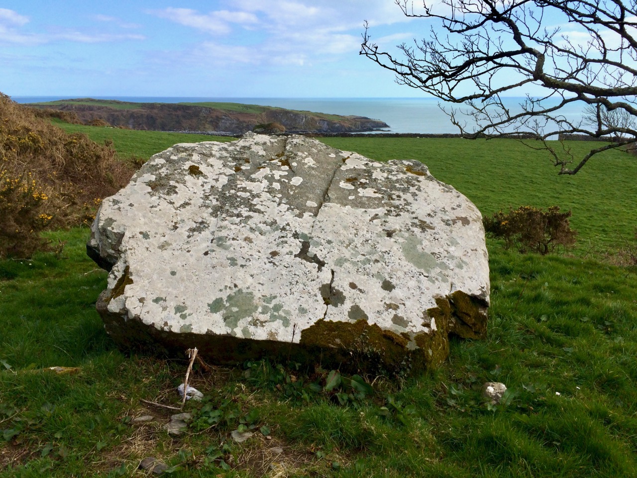
The Giant’s Grave, or fallen galláns, from the west side

While Boyle described this monument as two fallen galláns, it is unclear whether the placement of the two stones, one on top of the other, is accidental or deliberate. If deliberate, then this may be another type of megalithic structure, perhaps similar to a boulder burial (or clochtogle, as he preferred to call them). The orientation, then, as observed by Boyle in 1930 and by us in 2018, is from this probably Late Neolithic or Bronze Age structure to the place where other other pieces of rock art originally stood. Intervisibility, or the visibility of one piece of rock art from another, is well established in the Irish rock art literature. While we have written before (see here and here) about orientation from a piece of rock art to horizon markers, we have never before recorded a specific orientation, involving a solar event on a calendrical day, between rock art sites. So, this is a first for us, and may be a first for Ireland.

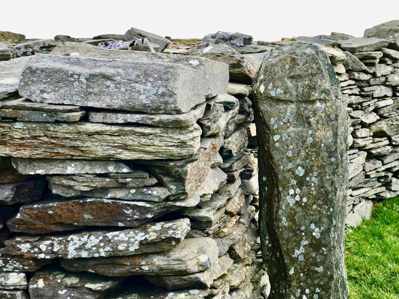
This is the Gortbrack stone, on its stand in the Stone Corridor at University College, Cork (UCC). It came from the townland next to Knockdrum Fort

In fact, it is easy to forget that three other examples of rock art come from adjoining townlands because they are no longer in situ: one is in the grounds of Drishane House and two are in Cork City. Six pieces of rock art less than 3 kilometres apart make for a ‘concentration.’

Above, the rock art currently in the grounds of Drishane House, but originally from Farrandeligeen

The Drishane House stone came from Farrandeligeen, immediately west of Drishane townland. In the field notes kept by Boyle, and discovered by Dr Elizabeth Shee, he notes that the stone was originally built into the wall of an outhouse. . . but was brought to Drishane House by Colonel Somerville in about 1880, for safe keeping.

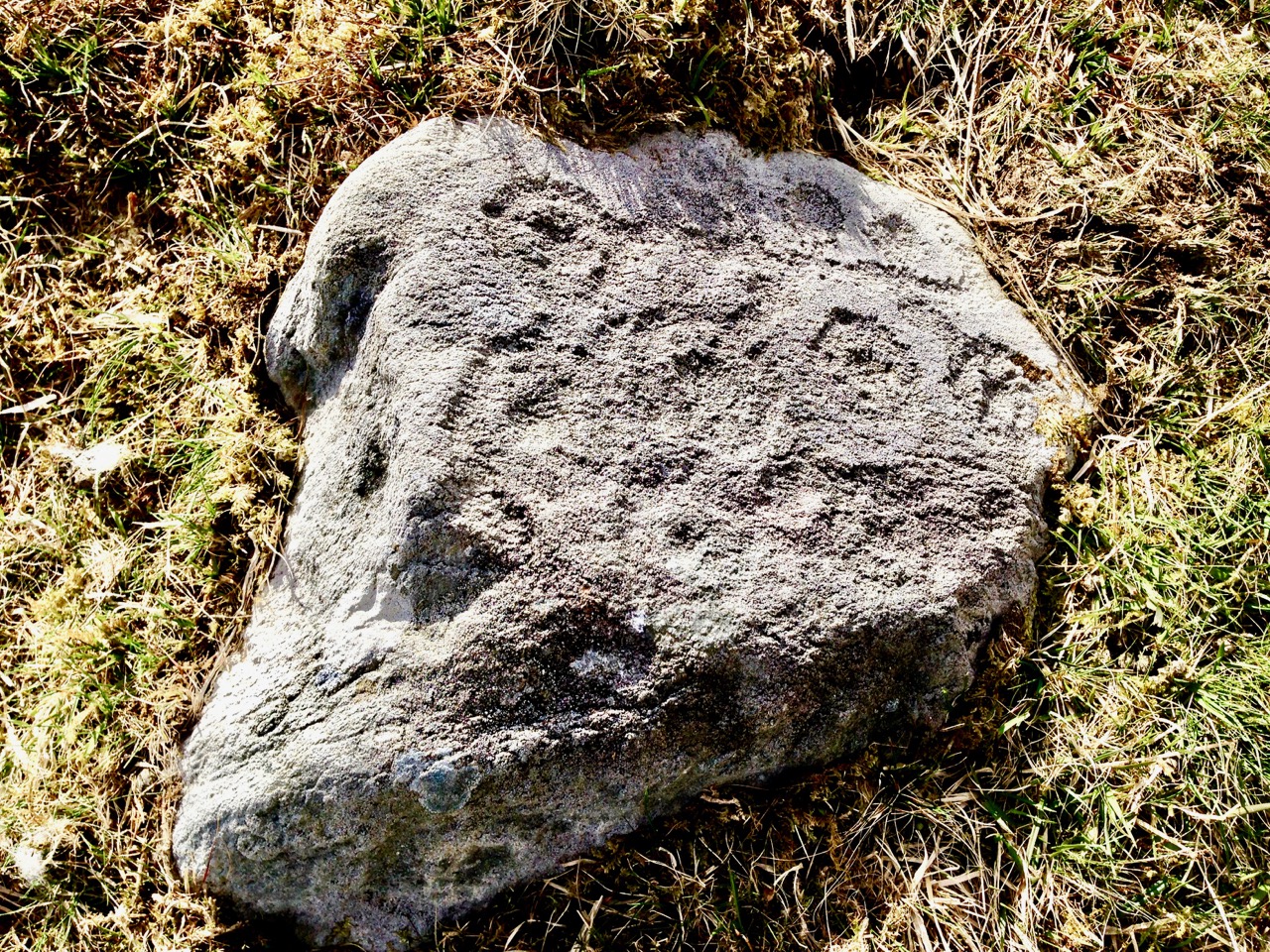
This is one side of the Bluid Stone (both sides are covered in cupmarks), which is housed at the Cork Public Museum

The other two pieces are from the townlands of Gortbrack, immediately to the west of Farrandau (the townland in which Knockdrum Fort is situated) and Bluid (either East or West) which is to the west of Gortbrack. Gortbrack is in the Stone Corridor at University College Cork, and the Bluid stone (an unusual two-sided example) is at the Cork Public Museum. Both had been in the possession of Boyle Somerville, and were presented to UCC after his death. They had been brought to him by local farmers who knew of his interest in such things. We can only lament that of the six separate examples of rock art known from this immediate vicinity, we can be reasonably confident that only one, the Giant’s Grave, is in its exact original location. Neither of the two pieces at Knockdrum Fort are precisely where they were found, but at least they do not seem to have been moved more than a few metres from their original situations.

There is scope for much more investigation of this intriguing group – we shall call it the ‘Boyle Somerville Rock Art Concentration’. But for now, let us once more raise a toast to Boyle, pioneering archaeoastronomer of West Cork.  His legacy lives on.

Lee Snodgrass and Mizen Archaeology

West Cork lost a friend and champion this week. Lee Snodgrass was involved in many movements, political and environmental, and participated in all kinds of events to do with heritage and meditation and yoga and music and art. But it was as an archaeologist we knew her first and best.

Lee and her partner, Paddy O’Leary, along with Bernard O’Regan, first launched the idea of the Schull Field Club in 1979. The aim of the club was to preserve, protect and record local monuments and to note the archaeology, history, flora and fauna of the Mizen.*

Ardintenant (White) Castle, sketch by Brian Lalor, done on a Mizen Field Club outing

It was very successful and soon there were monthly meetings, field trips and eventually, from 1993 to 2004 a highly regarded Journal, the copies of which are now jealously guarded by those fortunate enough to have them. The Field Club became the Mizen Peninsula Archaeology and History Society. Paddy and Lee were at the heart of all those efforts, although the real strength of the club was how many people got involved, led trips, gave talks and contributed to the Journal.

The Early Medieval site of Kilbrown on the Mizen. See our post Mizen Mud for photographs of this enigmatic (and very muddy) place

At Lee’s memorial service people talked about her elegance and style, her wayward sense of time, the tinge of glamour she brought to every occasion, the utter devotion with which she nursed Paddy through his long final illness.

The Cape Clear Passage Grave, spectacularly sited on the highest point of Cape Clear Island

Brian Lalor, a member of the Field Club, paid tribute to Lee as a ‘generative’ person – she got things done! She and Paddy were Mizen archaeology – the go-to people when new discoveries were made or when a monument was in danger. When the Cape Clear Passage Grave was discovered, they camped overnight on the mountain to confirm the orientation of the solstice sunrise. When a piece of rock art was discovered in the garden of a house in Schull, Lee wrote a full description of it that is still the only complete record. She was an excellent photographer and used her skills to record many monuments and artefacts.

Cooradarrigan rock art, discovered by accident on the garden of a new house

They explored and mapped the souterrain at Liss Ard, agitated successfully for the restoration of the stone row at Coolcoulaghta, helped to survey old graveyards – in short did their part and more to preserve and celebrate the heritage of the Mizen. Paddy is remembered and talked about still, and Lee will join him now when the stories are told of the couple who did so much for this area.

Dunbeacon Castle – there isn’t much left, but what a strategic siting, with a clear view all down Dunmanus Bay

We’ve known Lee only for the last five years, but like everyone else who knew her we liked and admired her. We picked her brains often on aspects of Mizen archaeology and she turned to us to record a new rock art find when she could no longer undertake it. We met her everywhere – lectures, gallery openings, festivals, concerts – always looking wonderful and always supportive of  local efforts.

Variously known as St Coleman’s Grave and a ‘penitential station’, this is one of a complex of monuments that includes a holy well and a boulder burial

I’ve chosen to illustrate this tribute to Lee with photographs and drawings of sites on and near the Mizen visited over the years by the Field Club. The drawings are all by Brian Lalor, from the sketchbook he has entrusted to me and which I have written about before in the post Brian’s Sketchbook: The Signal Towers. They were all done on trips with the Field Club.

Lee made a difference in West Cork. Isn’t that, in the end, what we all hope to do with our lives?

*Information based on the Introduction to the boxed set of the Mizen Journal, written by Deirdre Collins

Rock Art: Returning to Derrynablaha

Three years ago Finola and I both wrote posts about a remote valley in the Kerry hills, north of Sneem, where some iconic examples of Irish Rock Art can be found: Derrynablaha Expedition by Finola, and my own Glen of Ghosts. I think it’s time to revisit this hauntingly beautiful place, and its ancient carved stones which could date back 5,000 years, to Neolithic times.

All the examples of Rock Art illustrated in this post can be found in the townlands of Derrynablaha and Derreeny, Co Kerry

When Finola visited the valley in 1972 and 1973 she explored and recorded 23 marked stones, all within the townland of Derrynablaha: these were illustrated in her UCC thesis The Rock Art of Cork and Kerry. Between 1986 and 1996 The Iveragh Peninsula Archaeological Survey undertook further detailed research, resulting in a comprehensive volume published by Cork University Press: this contains a 30 page section on Rock Art and includes many of Finola’s drawings. The book lists 26 known examples, now, in Derrynablaha with a further 7 stones in the adjacent townland of Derreeny.

Cork University Press volume (left) which includes many of Finola’s drawings (sample page,right)

My introduction to prehistoric Irish Rock Art came in the early 1990s when I first visited West Cork to look at a piece of land which my friends Danny and Gill had purchased, with a view to building themselves a house: I was to be the designer. We walked the 5 acre site at Ballybane West and discovered a large, flat outcrop of rock some 30 metres long by 10 metres wide, the surface of which was covered with strange carved motifs. These intrigued and occupied me for many years. Eventually I made contact with the Department of Archaeology at University College Cork and unearthed Finola’s thesis. Finola had visited ‘Danny’s Rock’ during her explorations: she and I have just completed a comprehensive article on Rock Art in the environs of Ballybane West for a forthcoming edition of the Journal of Bantry Historical Society, due to be launched on 10 May.

Because of the number of pieces of Rock Art at Derrynablaha, as recorded by Finola, I set out to visit the site and was fortunate, I think, to locate several of the pieces there: they are hard to find. My most significant impression of the place was its isolation and loneliness: when Finola was there decades before, the O’Sullivan house was occupied – a family home and working farm – now it was a ruin returning to nature. No one lives in that valley today: it is home to sheep and eagles.

The most iconic piece of Rock Art in Derrynablaha is high up on the slopes of a mountain: there is no path, and the trek is across bogs, boulders and streams. Also remember that all the land is private – farmed now by another O’Sullivan from a neighbouring valley – and permission has to be sought in advance of any attempt to visit. Strict rules apply, understandably, to the use of gates and fences and no dogs will be permitted. The iconic piece is probably Ireland’s most important. When you stand up there, on a good day, you can see to distant horizons and take in outstanding views: time for reflection, perhaps, on what inspired our forebears to create such panels in these places – was it where they lived? Or did they assemble there for celebrations? The mountainside seems to present a natural platform here, with the carved rocks a central focal point. The work involved in carving these motifs would have been significant and time-consuming – they had only stone tools.

When we give talks about Rock Art we ask a question: Is it art? Some of it is certainly pleasing to the eye – the iconic Derrynablaha carvings are. But they also appear random, as though new carvings have been squeezed in amongst older ones: maybe the proliferation of motifs – or the number of carvers involved – was more important than any particular visual effect or relationship. We don’t ever try to answer that question, nor guess meanings for things we can never know. It’s enough – for me, at least – to experience these ‘footprints’ of former souls in such wild places.

We go far out of our way to look for Rock Art. It would take more than a lifetime to see every piece in Ireland. Some would argue that such a pursuit would be pointless – seen one, seen them all. It is true that the motifs are similar, although variable, across Rock Art panels, not only in Ireland, but in Britain and on continental Europe. That in itself is remarkable: 5,000 years ago humankind was making identical marks on rock surfaces all over its world. For me, however, it’s not really the motifs – spectacular though many of them are. It’s the places that they mark which are meaningful. Rock Art took me to the mountainside in that lonely Kerry glen and showed me a most incredible view across townlands and counties: I see it as inspiration, relevant as much in the 21st century of this struggling world as it was, perhaps, thousands of years ago, when the same world was a little bit newer.

The Headstones of Ferns

Ferns, in Co Wexford, is an historic town that boasts many fine heritage attractions including an Anglo-Norman Castle, an Augustinian Abbey and other medieval ruins, high crosses and associations with the McMurroughs and the Marshalls. Not least among its delights is the Cathedral graveyard, which has one of the best collections of eighteenth century headstones I have ever seen.

Look at the headstone above and the one below. The elements used in the carving are identical except that the central image in the first is a crucifixion scene and in the second it’s an IHS in a sunburst. Note the J Byrne signature under the carving to the left above and the Pat Byrne signature below. How were J and Pat related? Does the difference demonstrate anything other than the preference of the person who commissioned the headstone? I’m tempted to see the gradual replacement of the crucifixion image with slightly less ‘popish’ symbols, but I’m probably overthinking this

In our post Memento Mori, I introduced you to Irish headstones and the practice, which really only dates back to the 18th century, of routinely placing headstones on graves. Even then, only those who had the means to pay for a carved headstone were memorialised in this way – most still lay in graves with simple field stones at their head (and sometimes feet).

In Headstones or Folk Carvings? we visited Kilcoole graveyard to Co Wicklow, home to many fine headstones including one by Dennis Cullen, an acknowledged master carver. In Ferns we found many of the headstones had been carved by J Byrne (or J: Byrne, as he styled it) and although his technique does not quite have the refinement of Dennis Cullen, his carvings have a charm and energy that make them recognisable even where the headstone is not signed.

See the ‘J: Byrne’ signature just below the carvings to the right. There is no date on this headstone for William Lea (or Leacey? See the tiny superscript above the ‘Lea’). The detail on the angels is very fine and I love the little arrow in the centre of the sunburst, just below the IHS

The most common image is, of course, the IHS. Known as a Christogram, IHS is shorthand for the name of Jesus. It is often surrounded by a sunburst, or surmounted by a cross. Interestingly, the earlier and later headstones are more likely to feature the IHS as their main element.

Two early headstone, from 1758 and 1773, starting with Here Lieth. Mogue is a local name, for Saint Mogue of Ferns, whose well lies across the road. Note that the final Y of Mercy doesn’t quite fit on the line so a superscript is used

Many of the most interesting headstones date from the 1790s and where they have a signature it is that of J Byrne. There must have been a vogue for crucifixion scenes at the time, because they appear here and there throughout the graveyard and date to this period.

The J: Byrne signature is almost obscured by lichen. This is a typical J Byrne carving, with a crucifixion scene: Jesus on the cross, Mary and possibly John on either side, all three with halos. Sun and moon round out the carving

Jesus is on the cross at the centre of the tableau, with Mary on one side and John on the other. Occasionally other figures appear – Roman soldiers, a man on horseback, angels.

The dress, as is common with carvings of this period, reflects eighteenth century styles – observe the soldier in the frock coat in the Moses Breen scene (above) and the angel in the seamed jacket on John Kehoe’s stone (below).

There are a couple of headstone with horses in the crucifixion scene, but it’s unusual

The most frequent other symbols are the sun and moon, often with faces. The sun/moon symbols can be the main elements or can be wedged into available spaces on either side of crucifixion scenes.

The lettering styles vary, although generally they become tidier over time. Occasionally, the lines incised to keep the carver straight can be discerned. Words that don’t fit are either carried over, or a tiny superscript finishes them so they can stay on the same line.

The lightly incised ‘stay between the lines’ can be seen in Mogue Doyle’s headstone from 1775

This 1792 headstone is for Catherine Murphy. But it is also for her husband. However, none of the husband’s details appear. I can understand that he would have been added to the headstone at the time of her death, for efficiency perhaps, with his dates to be added later – but the fact that his name is missing gives rise to all kinds of speculation!

One mysterious element of several of the gravestones in Ferns is that at some point in the past someone has drilled holes in some of the headstones (see the two examples, below). If anyone can tell us the significance of this, we would be grateful to know it.

We highly recommend a visit to Ferns. Give yourself a day to take in all that’s there, but don’t forget to have a good wander around the old graveyard. Morning is best, as the light goes behind the headstones in the afternoon.

I love the primitive quality of this 1780 stone for Mary O”Danioley – Jesus on the cross with the soldier piercing his side with a spear

Darerca – A Neglected Saint

Ireland is ‘The Land of Saints’. The Catholic Online website lists 331 of them, but some get much better treatment than others. Last week we celebrated St Patrick – the news was full of it, as it always is on 17 March. Yet, just five days after Patrick’s Day – on 22 March – I was at a schoriacht and asked the assembled crowd who was the Saint for that day: nobody knew. It was the day for St Darerca and she is, unfairly, much neglected, especially since she is St Patrick’s sister. In order to redress the balance I have put together everything I can find on the story of St Darerca, and – because she has never been pictured (as far as I can tell) – I have illustrated it with some general Irish Saintly connections.

Land of the Saints: header picture – Clonmacnoise, Co Offaly – Ireland’s holy centre, and one of the oldest and most important early Christian settlements in Europe. Above – the beautifully located Kilmalkedar monastic site in Kerry has long associations with Saint Brendan the Navigator

St Darerca is first mentioned in the Vita tripartita Sancti Patricii (Tripartite Life of Saint Patrick), which some scholars believe was written in the sixth century – within a century of St Patrick’s death (possibly in 493 at the age of 120). In the Tripartite Life, we read that St Patrick had two sisters, and that when he came to Bredach in County Derry for an ordination, . . . he found there three deacons, who were sons of his sister Darerca . . . These deacons were eventually ordained bishops and became St Reat, St Nenn, and St Aedh, the . . . sons of Conis and Darerca, Patrick’s sister . . . 

Upper – St Patrick’s Bell; lower – inscription on another 10th century bell – both now in the National Museum, Dublin

In his own Confessio, St Patrick makes no mention of his sisters. The Confessio begins:

. . . My name is Patrick. I am a sinner, a simple country person, and the least of all believers. I am looked down upon by many . . .

But it’s a very brief account of his life, and hardly qualifies as an autobioigraphy.

Medieval cross head, in the National Museum, Dublin

One version of the Tripartite Life suggests that both sisters were kidnapped from Britain along with St Patrick and returned to Ireland with him when he set out on his missions. A 17th century Irish hagiographer, John Colgan, collected fragments of information pertaining to Darerca . . . from Irish tradition . . . He asserted that St Darerca may have had as many as seventeen sons between two husbands, and that all of them became bishops. He also states that, according to tradition,  many of these became saints:

. . . By Darerca’s first husband, Restitutus the Lombard, she bore St Sechnall of Dunshaughlin; St Nectan of Killunche, and of Fennor (near Slane); of St Auxilius of Killossey (near Naas, County Kildare); of St Diarmaid of Druim-corcortri, in addition to five other children. By her second husband Conis the Briton, she bore St Reat, St Nenn, and St Aedh; ancient Irish authors also attributed her motherhood to St Crummin of Lecua, St Miduu, St Carantoc, and St Maceaith . . .

A 1950s photograph from Tomás Ó Muircheartaigh showing the annual pilgrimage to the summit of St Patrick’s holy mountain in Co Mayo, Croagh Patrick

St Darerca’s second husband, Conis, was said by some to be the King of the Bretons, although others only suggest that, by him, she gave birth to Gradlon the Great, who became King of Brittany. It’s really surprising (and a shame) that we don’t know more about Darerca: perhaps she has just always been overshadowed by her famous brother. As well as – perhaps – seventeen sons, she is supposed to have had four daughters, all of whom were also connected with the spread of Christianity in Ireland. Only two are named: St Eiche of Kilglass and St Lalloc of Senlis.

The Ardagh Chalice, National Museum, Dublin

There is a reference to Darerca as having another name: Moninna, said to have founded a convent at Killeevy, Co Armagh which was second in importance only to that at Kildare. A curious story is told to account for the change of her name to Moninna. The Irish commentary is translated into English by Whitley Stokes:

. . . Darerca was her name at first. But a certain dumb poet fasted with her, and the first thing he said after being miraculously cured of his dumbness was minnin. Hence the nun was called Mo-ninde, and the poet himself Nine Ecis . . .

Moninna studied theology, established convents in Ireland, Scotland and England and travelled to Rome. Perhaps most interestingly she is also known by the name Liamain, and there is a connection with an ancient stone on the island of Inchagoill in Lough Corrib. The ‘Pillar Stone’ on that island is known as Lugnaedon Pillar, a piece of Silurian grit stone, about two feet high with an incised cross on the north side, and two such crosses on each of the other sides. The inscription on the stone translates as . . . The stone of Lugnaedon, son of Limenueh . . . or Liamain. The pillar is said to originate in the 6th century, and would therefore be the oldest Christian inscribed stone in Ireland.

Two photographs of the 6th century Lugnaedon Pillar on Inchagoill Island. It is also known as the Rudder Stone because of its shape

The Benedictines say that Darerca’s name is derived from the Irish Diar-Sheare which means ‘constant and firm love’. And, finally, a piece of local folklore say that St Darerca blessed a poor man’s beer barrel so that it provided an endless supply of beer ever after!

Lives of the Saints – a detail from a stained glass window by George Walsh in St Kentigern’s Church, Eyries

So there you have it – scraps gleaned from many sources, some of which are not named – from which we can piece together an incomplete picture of an Irish saint who may well have done as much in her day for Christianity in Ireland as her famed brother. How about giving Patrick a rest next year and, instead, celebrating the day of St Darerca?

Knockdrum Stone Fort

There is no firm line that denotes where our most south-westerly Irish peninsula begins. Our series, Mizen Magic, has reported on walks, roads, views, history and archaeology which can definitely be defined as belonging to the Mizen (which we tend to think of as being to the west of, and including, its ‘gateway’ – Ballydehob). Perhaps we should start a series titled Magic Beyond The Mizen – in which case this would be the first: a report on a very prominent site about half an hour’s drive along the coast east of where we live: a historic structure – built within the last 2,000 years – but which contains evidence of much older human activity.

Here is an overhead view – the best way to see and understand the layout and construction of Knockdrum Stone Fort, which occupies a superb hilltop location in the townland of Farrandau between Skibbereen and Castletownshend. Thank you, Dennis Horgan – our professional West Cork aerial photographer – for allowing us to use this image: have a look at his website for other examples of his work, and for details of his excellent photographs and books.

The Fort is located on a high ridge (although not on the summit of the ridge) with far-reaching views both inland and to the south, over the sea. The header picture looks from the Fort out to the west over Castlehaven to Galley Head in the far distance; the view in the picture above is due south – looking towards Horse Island, and the stone wall of the Fort is in the foreground. From these breathtaking vistas it’s reasonable to conjecture that Knockdrum Fort has a strategic siting, providing views of anyone approaching from the sea, and able to signal their arrival to dwellers in the ‘interior’ – the lands to the north. We cannot know for sure that stone fort structures had this – or any other – specific purpose: many theories have been advanced. Comparison with other examples is worthwhile. One of the largest stone forts in Ireland is Staigue Fort, near Sneem in County Kerry.

Staigue Fort (above) has a diameter of 27.5 metres, the present wall height is 5.5 metres, and the wall thickness is 4 metres. At Knockdrum the diameter is 22.5 metres, the present wall height is 2 metres and the wall thickness around 3 metres. The Duchas information board at Staigue says:

. . . This is one of the largest and finest stone forts in Ireland and was probably built in the early centuries AD before Christianity came to Ireland. It must have been the home of a very wealthy landowner or chieftain who had a great need for security . . . The fort was the home of the chieftain’s family, guards and servants, and would have been full of houses, out-buildings, and possibly tents or other temporary structures. No buildings survive today . . .

The picture above shows the present interior of Knockdrum Fort: the stone walls are likely to delineate a former building here. In the corner of the inner stone enclosure is the entrance to a ‘souterrain’ – a series of underground passageways. The souterrain is outlined on the following drawing of the Stone Fort which was made in 1930 after a detailed investigation of it by Vice Admiral Henry Boyle Somerville, the younger brother of writer and artist Edith Somerville of Castletownshend. Boyle, his life and his tragic death, is the subject of Finola’s complementary post today.

Finola is also discussing Boyle Somerville’s interest in the alignments of archaeological structures. In Boyle’s paper for The Journal of The Royal Society of Antiquaries of Ireland, 1931 (title page below), he presents the evidence that this Fort is on a solar alignment.

Boyle sets out the case for an alignment based on the Knockdrum Fort:

. . . This conception of the earlier use of the site of the cathair [the stone fort] for purposes which may perhaps be termed “religious,” seems to be borne out by the following fact. At a horizontal distance of about 600 yards to the E.S.E of the cathair, and at 210′ difference of level below it, there is a small rocky ridge standing up from the surrounding grass land. The name of the ridge is “Peakeen Cnoc Dromin,” The little peak of the white-backed hill . . .

The following paragraphs and photos are from the Journal paper:

Finola and I are familiar with the Peakeen Cnoc Dromin from our researches into Rock Art: the uppermost stone (which does appear similar to the capstone of a fallen dolmen) is heavily cupmarked. The photos of the Peakeen (above) were taken before we had any idea that they might form an alignment connected with Knockdrum Stone Fort. We will have to revisit again at Bealltaine. Boyle confirmed his alignment theory by personal observation:

He went on to suggest:

. . . It is one of the clearest instances of intentional orientation between two ancient, and artificially formed monuments that can be imagined . . .

Of course, it can’t be the case that a cupmarked stone dating from anywhere between 3,000 to 5,000 years ago was in any way connected with a stone fort that dates from the early part of the first millennium AD. However, I have as yet omitted an important piece of information: at Knockdrum Fort, high up on the hill, are two further ancient cupmarked stones – and significant ones: the larger also exhibits Rock Art. Somerville illustrated them in 1930, and Finola recorded them in detail in 1973.

Images above are of the stones recorded at Knockdrum: topmost is Boyle’s drawing from 1930. Below Finola’s drawings are photographs of the large stone lying by the Fort entrance today: it is known that this has been moved, possibly during Somerville’s time. The old photograph immediately above is from the Coghill Family Archive and shows Arthur Townshend beside the stone, which is standing. Arthur was born in 1863: this photograph may record the occasion of the expedition by the young Somervilles and ‘their cousin’ (quite possibly Arthur) to Knockdrum described below, which took place in 1875. It is the presence of Rock Art and cupmarks at the Fort itself which tells us that the site must have had significance in far earlier times (perhaps that’s why the fort was sited in that location – rather than on the summit of the ridge), and Boyle’s reported alignment would have been with the carved rocks (or the important location that they marked) rather than with the comparatively modern stone fort.

The souterrain in the enclosure of Knockdrum Fort (entrance in top photograph – ‘chimney’ in lower photograph) was explored in 1875, as Boyle recounts:

The ‘band of three youthful archaeologists’ are likely to have been Somervilles: Edith (the eldest, then 17), Boyle (then 12 – it was he who was lowered down into the discovered ‘cave’ by his ankles!) and, probably, a cousin. Great adventures, which would undoubtedly raise eyebrows today.

Within the fort enclosure is this cross-marked stone. It was apparently leaning against the wall in Boyle’s days, but has now been embedded close to the entrance. We visit this site often: this time we noted some significant disruption to the upper level of the dry stone walling, possibly caused by the fierce storm winds earlier this year. Compare the detail below with Dennis Horgan’s aerial view above, taken a few years ago.

Some damage has also been suffered to retaining walls on the green boreen leading to the Fort from the main Skibereen – Castletownshend road (a walking route only), and on the stone walls beside the 99 steps which take you from the green path to the top of the hill. These are passable with care, but it is hoped that this monument – which is in State ownership – will be deservedly returned to good order before too long: it is one of the historic wonders of West Cork.