Ballydehob on Bahnhofstrasse!

What are all these people looking at? Is this Ireland? And when? Firstly, what they are looking at is a street performance – and the performers are Irish – not just Irish, but all from West Cork! And, the spectators are in Switzerland! We know exactly when this happened: 34 years ago. Here’s the story, and here is what they were watching:

Brian Lalor – Curator of our Ballydehob Arts Museum – was one of a group of artists who travelled from West Cork to Zurich in May 1985 to put on a large exhibition of their work in the city. He is telling the story through one of the two new exhibitions which has just opened in Bank House, Main Street, Ballydehob – and which will be running through to September this year. Plenty of time to come and have a look, but don’t miss it! The exhibitions can be seen when the Mizen Gateway Tourism Centre is open in the former bank building, right in the centre of town. Generally, Bank House is open Mondays to Wednesdays, 12 noon to 6pm, and Thursdays to Saturdays, 11am to 5pm. Because the centre is partly run by volunteers, please check by phone prior to coming: 028 25922.

The original 1985 exhibition poster was produced as a limited edition artwork by Coilin Murray, one of the participants

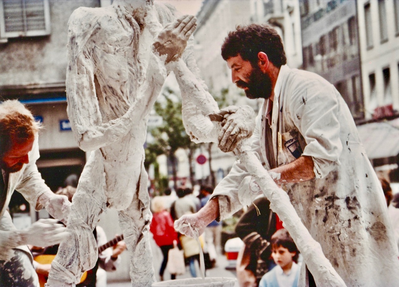
Having set up the exhibition in the Reithalle, Zurich – a fine, capacious premises, the artists realised that relatively few people were coming to see it, as it was a fair way out of the main thoroughfares, and little publicity had been organised in advance. So they put their creative heads together and came up with the idea of making a piece of art in the city centre – something which no-one could ignore.

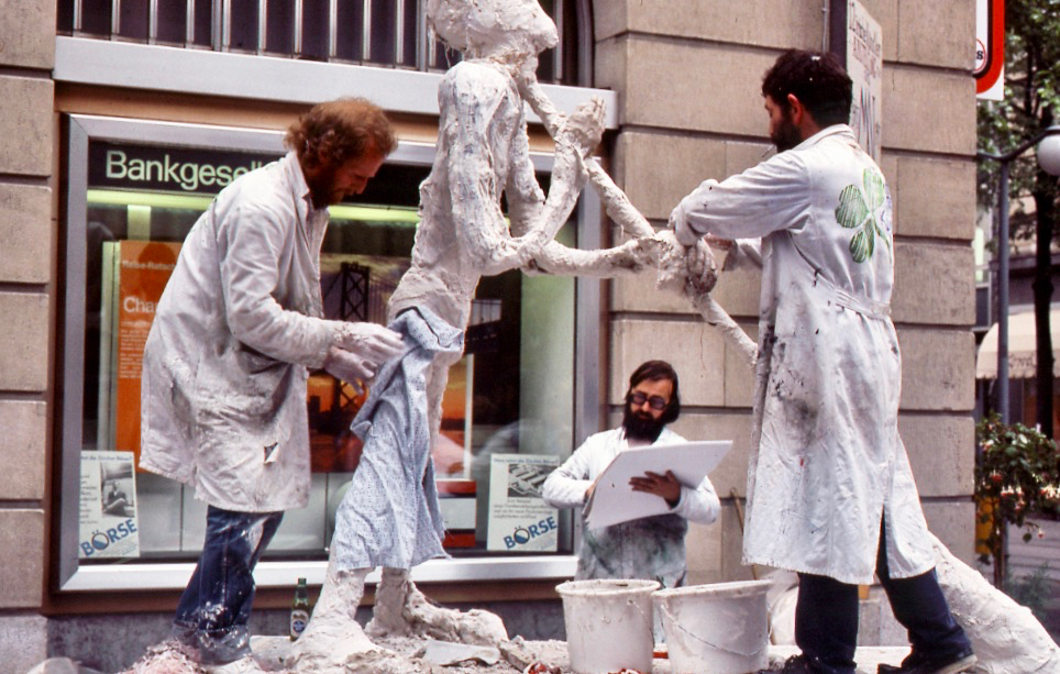
The artists took as their starting point one of the most important sculptors of the 20th Century, Alberto Giacometti, from Switzerland. He was famous for his ‘matchstick figures’: have a look at the book cover above. Ballydehob’s version of ‘Giacometti’ was built on a trailer – mainly by artists Ian Wright and Pat Connor – and he was playing an Alpenhorn. Brian Lalor made several sketches of the event (you can see him in the picture above, and one of his sketches above that): these sketches have lain dormant for 34 years and have not been shown anywhere until the Ballydehob exhibition, where they are being unveiled for the first time. Although a serious business, it was all a bit tongue-in-cheek. I think you can tell that by the name the artists gave their statue – Jack O’Metti! However, it was a tremendous success, and the crowds came flocking.

A further dimension was added to the street performance when John Verling had his legs encased in a plaster cast by Ian Wright, all the while singing the sean-nos song ‘The Rocks of Bawn’. The significance of this particular event escapes me . . .

At the opening of our exhibition last Thursday, there were present several of the artists from the early days, some of whom had contributed to the events of Zurich ’85: it was an historic occasion!

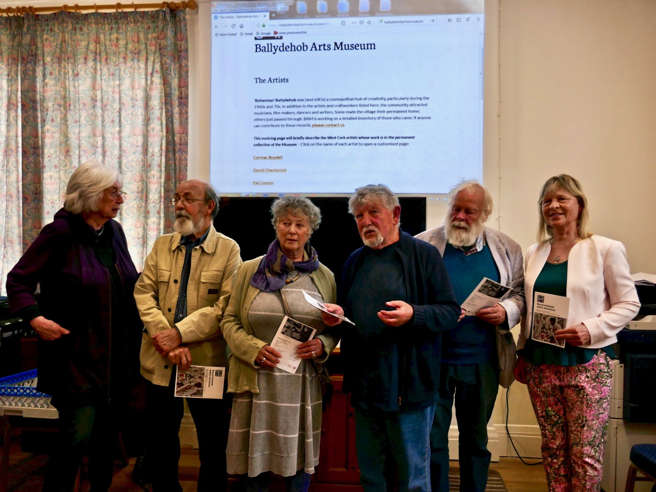
A line-up of West Cork artists from the heady Bohemian days: Birgitta Saflund, Brian Lalor, Leda May, Pat Connor, Jim Turner and Carol James. All pictured together at this week’s opening of the Ballydehob Arts Museum

There’s more! The Ballydehob on Bahnhofstrasse story is only one of the new exhibitions in Bank House; the other is The Irish Tea Ceremony. If that intrigues you, I’m not going to give the game away. Come and see for yourself what goes on in this little corner of Ireland – and be amazed!

Find out much more by visiting our brand new website – launched along with the exhibition:

www.ballydehobartsmuseum.com

Miniature World

A bog seems at first like an unpromising site for photography but all it takes is getting close. This isn’t as easy as it sounds, since bogs are wet places, but having arrived home sodden but exhilarated I’ve decided it’s definitely worth getting wet. My role model in this type of close observation is Tina Claffey, whose book, Tapestry of Light, and whose Facebook Page are constant sources of inspiration. Tina – thank you! We must be twin souls because like you I return again and again to the same patch of bog. Time loses meaning as I simply lie and let my eye tune in.

My little patch is quite close to my house and I described it in my post last year “The Wildest and Richest Gardens” – West Cork Bog Soaks. It’s taken a while this spring for the Cappaghglass soak to wake up but it’s well and truly alive now so here’s what’s there already.

On the rocks

First of all, the soak is surrounded by heather and rock. Lying on the rock, with my face a few centimetres from the surface, I have become aware of the rich lichen growth all around me. I don’t know a lot about lichens but I have been studying this one (above and below) – Devil’s Matchstick.

It’s obvious how it got that name, and it’s sometimes also known as Nail Lichen too. It’s only about a centimetre high, about the length of my little fingernail. The Latin name is Cladonia floerkeana. In Ireland we get this bright red form of it, whereas in North America the tips are black.  The site I go to to learn about Lichens is http://www.irishlichens.ie. Here’s what they say about lichens on their home page:

Lichens are dual organisms; a fungus and one or more algae in a stable, mutually beneficial (symbiotic) partnership. The fungus provides structural form and protects the algae from extremes of light and temperature. Algae are capable of photosynthesis and some of the sugars produced provide the fungus with energy for growth and reproduction. Some lichens can live for many hundreds of years and being sensitive to pollution levels they are important environmental indicators.

There are several red-tipped lichens in the Cladonia group so I must look out for others. The trunk is described as squamulose which simply means scaly, at the bottom and becoming fruticose (or shrubby) as it grows. The stems are called podetia, and they are topped by the bright red apothecia. Yikes! Don’t think I’ll become a lichen expert in this lifetime.

And look at this one, that looks like a goblet – it’s another Cladonia but I don’t know which one. And lots of white lichen to boot. It’s a whole world down there on the rock, under our feet. 

Let’s move over to the the bog soak now and look at two things in particular. The first is the Sundew. At first I thought it wasn’t up yet, but as I got closer I realised that it was just emerging from the surrounding Sphagnum moss (the second thing).

Besides looking weirdly otherworldly, the Sundew is a clever little critter, well adapted to this habitat. It’s developed a special mechanism to ensure it gets the nutrition it needs, since there isn’t much in the bog. It traps insects on its little sticky hairs, then the leaf rolls rolls over and digests them.

You might not want to watch this video if you have a weak stomach

The sundew does have a little white flower, but it’s the leaves that are the centre of all the action on this plant. Our bog soak has the Round-leaved Sundew, which is more common in Ireland than the Oblong-leaved Sundew that you saw in the video.

A hapless ant is this Sundew’s meal

Finally, as I was nosing around (er, literally) among the Sphagnum, I saw that some of them had these little brown caps and I wondered what they were. It turns out that mosses propagate by means of spores, and the caps are little exploding spore capsules. When they blow, they fire the spores great distances.

Take a look at the spores exploding in slow motion – it’s quite a sight.

Some of the capsules in my little patch had exploded already – you can see the empty cup-like capsules in the photograph below – at the bottom of the picture..

Sphagnum itself is an amazing moss – we wouldn’t have bogs without it, as it’s what holds all the moisture. The Irish Peatland Conservation Council has an excellent information page on Sphagnum. It includes this:

A huge number of tiny microscopic plants and animals live with Sphagnum mosses. A few drops of water squeezed from wet Sphagnum contains hundreds of microscopic species such as desmids, diatoms, algae, cyanobacteria, amoebae, rhizopods, flagellates, ciliates, rotifers (wheel organisms), worms, nematodes (round worms), flat worms and heliozoans (sun animals). One scientist counted over 32,000 microscopic animals from a Sphagnum moss growing in a bog pool!

Now that’s a bit too miniature for my lens. I’m happy at the magnification I can achieve with my Lumix. If you need me, you know where I’ll be.


Mizen Magic 15: Long Island

The summer sun is falling soft on Carbery’s hundred isles— 
The summer sun is gleaming still through Gabriel’s rough defiles—

(from Thomas Osborne Davis The Sack of Baltimore 1844)

Up here in Nead an Iolair (Eagle’s Nest) we look out over the Carbery Islands. There are supposed to be a hundred of them, although some are just little rocky outcrops: the tips of underwater mountains at the margins – and the mercy – of the Atlantic.

Horse Island, Castle Island and Long Island lie along the length of the coast below us. Peter Somerville-Large (The Coast of West Cork 1972) quotes a tradition that they all used to be one island:

In the latter end of March, AD 830, Hugh Domdighe being monarch of Ireland, there happened terrible shocks of thunder and lightning . . . At the same time the sea broke through the banks in a most violent manner, The Island, then called Innisfadda, on the west coast of this country was forced asunder and divided into three parts.

Long Island is still known as Inis Fada in the Irish language: the Anglicised name is a direct translation; header – the long road that winds from East to West on Long Island; second picture – the Wester village seen above the Atlantic breakers on the wild and battered far shore

We had a day’s adventure on the island, walking almost the full length of it; Finola was madly busy identifying all the wildflowers. It’s part of the magic of Long Island that we covered a distance of over 10 kilometres in the day, although the length of the island tip to tip is just over 4k. There is a regular ferry to the island from Colla Pier (not every day of the week), but we chose to travel from Schull pier with Helen of Schull Sea Safari (a whale watching trip with Helen will be a future outing for us). Our mode of transport was Helen’s very fine large RIB, the Kealtra – superbly equipped. With a hard south-easterly wind the waters were very choppy and we had to be fully kitted out for the crossing!

Upper – intrepid travellers kitted out for a choppy crossing on the Kealtra! Lower – skipper Donie taking the RIB out of Schull Harbour

After the heady excitement of a blustery crossing, stepping on to the tranquil world of Long Island is a magical experience. You are immediately aware that the place holds memories – and ghosts – but is still a community in the modern world thriving against the odds.

Everywhere there are signs of the past: abandonment, fading history, but also livings still being forged from the environment. The sadness is the obvious population decline. Looking through the available census records, a melancholic picture emerges: 1841 – population 305; 1911 – population 143; 1951 – population 74; 1991 – population 11; today – population 7 (and that’s an increase of 1 from 2 years ago). There was once a school: the decaying building is now a lonely waymark at the centre of the island’s single boreen.

The Island School – long deserted and gently decomposing

Peter Somerville-Large in conversation with the local residents during his visit half a  century ago:

I talked to Mr McCarthy, who had lived here all his life and could remember when the place had been full of fishermen all speaking a mixture of Irish and English. One by one he had watched them leave. A dozen families still remained, comprising perhaps forty people altogether. The school had shrunk year by year, to four pupils, then two – it closed after that. There was neither electricity, nor any shop – nothing to keep the young from making the short crossing over to the mainland. It would take them fifteen minutes, according to wind and weather. There they disappeared for ever. When the old ones like himself died out the place would become empty.

Contrasts at the west end of Long Island

Although there are many houses that are intact and well looked-after (a number are holiday homes), you would think that the odds were ultimately stacked against the survival of this island. Yet those who do live here full-time have tenacity – and there is fresh energy. Helen and Maurice have built their own new house and run businesses which allow them to be island based, while Castaway East is a ‘Place of New Beginnings’, a venture offering B & B or full board and – if you want – retreat packages to recharge your batteries. Peter and Tracy are also experts in garden landscaping as can be seen from the works they have carried out for themselves.

The East end of the Island: you can walk past Peter and Tracy’s ‘Island Retreat’ to the old copper mine and navigation beacon

We were pleased to find that the island’s well has been maintained and presented in excellent order – mainly by Joe, one of the Islanders. It’s a little haven, not to be missed. The day’s adventure gave us so much photogenic material – I will be returning to this magical place in a future post.

Long Island Wildflowers – a Reconnaissance

Robert and I set off on Tuesday for Long Island and enjoyed everything about it. See his post Mizen Magic 15: Long Island for a full account of our day. One of Roaringwater Journal’s New Year Resolutions was to spend more time on the islands and this was an excellent start! I was there mainly to take a look at the wild flowers, with a view to leading a wildflower walk there later in the year. Do let me know if you’d be interested in coming along, in the comments section below.

I’m used to seeing Bird-foot Trefoil in my garden, but here it’s spread to the stony beach and looks wonderful

Wildflowers come and go, so what I saw was a lovely selection of late spring and early summer blooms. I also got a feel for the character of the island and the habitats it hosts.

The maritime habitat was rich with Thrift, Trefoil, Kidney Vetch (also the lower photo) and Sea Campion

It would be lovely to be able to say that the island is pristine and free of invasive species, but alas we did see some Japanese Knotweed along the way. We are left scratching our heads as to how it manages to spread like that.

The uncultivated higher ground was particularly colourful, with Lousewort predominating. In this photograph you can also see the yellow of Tormentil and the pale flowers of Common Milkwort (see below for more on this Milkwort)

I don’t think I have ever seen such a profusion of Lousewort (below) anywhere else and this is one of the things that gives Long Island a particular colour at this time of year. It’s not a pretty name, for what is, in fact a beautiful little plant, but it was so called because it was believed that sheep got lice from eating it. This has never been proven, but the name stuck. Long Island, with its acres of damp moorland, provides the perfect habitat for Lousewort.

It’s also perfect for Tormentil and Common Milkwort (below). This last flower is tiny – you have to get your face up close to the grass to see it and it’s normally a deep purply-blue. However, on Long Island there were lots of very pale Milkwort, almost white. Although I knew that Milkwort came in pink and white, besides dark blue, I had only seen blue before this year. Now I have to find some pink!

The Yellow Iris (below), which most people call Flags, are in abundance in all the marshy areas, creating a colourful swath here and there. Up close, they are very dramatic. Here, it’s native and welcome, but in North America it has become invasive, choking waterways and displacing native plants.

A couple of unusual flowers to end with, beginning with Musk Stork’s-bill (below). I found this little beauty before in a graveyard in Rosscarbery but this is the first time I have seen it near where I live. It’s described as ‘probably introduced’ which means that it’s not native but has been here a long time.

The flowers of the Stork’s-bill look very like a Crane’s-bill, but the leaves are hairy and they have these funny spiky seed pods, both of which help in identification

Finally – who can resist an orchid? There are several kinds of Marsh Orchid, but I think this one (above and below) is the Irish Marsh Orchid. We saw it before on Cape Clear, so it obviously loves islands! I was glad I had my hand lens with me, as this is best viewed close up.


Witches’ Marks and Lovelorn Shepherds: Inscribed Rock Art in a Remote Valley

One day in the summer of 1972 I set off on my Honda 50, backpack full of recording tools, to find a new and different example of rock art. This was not my usual prehistoric cup-and-ring carving, but inscribed or scratched markings in a ‘cave.’ When I returned yesterday, 47 years later, it was to a place even more remote and wildly beautiful than it had been in my memory. Read Robert’s post for a full account of our walk up the Valley of the Cooleenlemane River.

The site itself is arresting. Huge slabs lean against each other to form three shelters – nowadays harbouring sheep but in times past, perhaps humans. There is an account in the Halls’ Tour of Ireland of an encounter they had with a family living in this area in what looks remarkably like our destination.

The House of Rocks from Ireland, Its Scenery, Character, &c by Mr and Mrs S C Hall, page 149. Drawn by A Nicholl, engraved by Landells

The ‘caves’ are known locally as the Bealick – Pat Joe pronounced it The Bay Lick. Leach (pronounced lack) is the word for a flagstone or slab so this could be a reference to the enormous stones themselves, but baoleach (pronounced bway-lock) is also the Irish word for dangerous, which may refer to beliefs about the power of the place. The townland name, Cooleenlemane, could mean the Little Nook of the Rock Outcrop, or it could mean the Rock Outcrop at the Remote End (of the valley). Either way, it’s apt.

The arrow points to the Bealick: you can see it from a long way away as you walk up the valley

We’ve written many posts about rock art in this blog, but the closest we’ve come previously to dealing with Inscribed markings was Robert’s post on the Aultagh stone, which has been suggested as an Ogham (or fake-Ogham) stone. This one is very different.

This type of site has been described most comprehensively in Elizabeth Shee Twohig’s paper, An Enduring Tradition, Incised Rock Art in Ireland in the 2014 book From Megaliths to Metal: Essays in Honour of George Eogan. She coins the term COMBS, based on where these kinds of marks occur – Caves, Outcrops, Megaliths and Boulder-Shelters, and gives details on the ones that have been documented to date, including the list I included in my 1973 thesis.

I described and drew three of the sites then – Glanrastel, Kealanine and Cooleenlemane – and I hope to get back to the others also. Of the three, Cooleenlemane has the greatest range of markings. There are three caves here, but markings only in two, which I labelled the East and West Cave. The markings run the full gamut of Shee Twohig’s motif range. There are also initials and words and letters that do not form words but that seem to run together.

The East Cave has the widest range of markings

This is what I wrote in my 1973 thesis about how the carvings were made:

The three sites of Glanrastel, Kealanine and Cooleenlemane share an identical incising technique. The markings have a V-shaped cross-section with smooth faces. In the case of the lighter marks, this effect could have been achieved by scratching with a strong knife, and at Kealanine and Cooleenlemane this technique accounts for many of the initials and letters, and some of the straight strokes. The deeper strokes were probably made by reaming with the end of a pointed tool. This tool need not have been metal. Identical techniques of marking have been identified by Shee. . . from passage-graves, which she suggests were executed with the edge of a stone axe.

The West Cave has more words and letters

At the time, we had no idea how to interpret these kinds of markings. I did say in my thesis they were more likely to be historic rather than prehistoric, and pointed out the Christian nature of the many cross motifs. The initials and words are, of course, fully modern.

But in fact, incised markings such as these are known from many contexts, including prehistoric. They are widely distributed in southern Europe, where they may be associated with figurative carvings also. The 2014 Proceedings of the XVII UISPP World Congress was published as Post-Paleolithic Filiform Rock Art in Western Europe, filiform being the word chosen to describe incised rather than pecked rock art. A chart of what the authors call The Geometric Type (above) contain many motifs that would be at home in Cooleenlemane. Some of these may date from the Bronze Age or the iron Age.

Shee Twohig also points out the long and varied traditions of marks of the COMBS type, including Early Medieval inscribed crosses on rock outcrops, and thirteenth century mason’s marks. You may remember our post about Keith Payne’s exhibition, Early Marks: inspired by Genevieve von Petzinger’s book The First Signs, he depicted many such inscribed markings, including one from Blombos Cave in South Africa, reckoned to be 75,000 years old.

A recent discovery at Creswell Crags in Nottinghamshire generated excitement earlier this year and may hold the answer to the puzzle of what at least some of these marks are all about. Dubbed Witches’ Marks, they are believed to have been tokens to ward off evil spirits. According to this BBC piece Protection marks are most commonly found in medieval churches and houses, near the entrance points, particularly doorways, windows and fireplaces. They are also often found in caves and shelters, near the entrance.

I said some of those marks – The initials and words, to my mind are equally important as evidence of our enduring need to leave our, er, mark on the world. How many generations of DKs (Several Dinny Keohanes, apparently, lived around the valley) carved their initials and hoped to be remembered? And was someone in the West Cave, in the time honoured-tradition of the love-struck everywhere, trying to make a declaration while sheltering with his sheep against a spring gale?

In the inevitable way of such special places in Ireland, the Bealick eventually became known as a Mass Rock (see this post for an explanation and examples) and it is described thus in the National Monuments records (Monument number CO091-003). Indeed, it would have made an excellent location for a mass rock, remote and hidden in its lonely valley.

From this angle you can see the three caves. There are no markings in the closest one

Seeing it again after all these years, I was struck by wonder at how my 22 year-old self managed to find it (I suspect I would have applied to the nearest dwelling and been directed there after multiple cups of tea and slices of brown bread) and to draw it. It must have taken hours then, but the 20 minutes I spent stooped inside yesterday trying to get photographs just about crippled me. But mostly what I felt was gratitude – first for the privilege I had been granted all those years ago of doing something so exciting and important for my thesis, and second for the untouched and pristine nature of the Bealick and its setting.

(Thanks, Keith, for the inspiration for this shot)

Cooleenlemane – A Walk into History

Finola has written about the destination of our adventures yesterday – the inscribed ‘caves’ at Cooleenlemane. Above is a photo of the view from the ‘cave’ entrance, looking back at the glen which we journeyed across. My post today is about that journey on foot through decades of human history and thousands of years of topographical transformation.

Upper – looking back and leaving the world behind: a rough track climbs up from the entrance to the Cooleenlemane valley and very soon we were absorbed into the wild emptiness of the mountainsides (lower)

When I looked into the furthest reaches of the glen as we made our way over the rocky track I saw first, in my mind’s eye, the movement of the glacier which shaped it – the splintering, shuddering path it took and the debris it left in its wake: strangely distorted outcrops and huge erratic boulders feigning dice unrestrainedly scattered by a random hand.

Scribings on the rocks in the glen of Cooleenlemane: these are made by nature (and the movement of glaciers) long before humans appeared in Ireland. I often wonder whether observation of these marks could have inspired our earliest artists?

Then I couldn’t help the vision that came into my mind of herds of the huge Irish Elk – Megaloceros giganteus – that ruled places such as this in Ireland after the ice receded 10,000 years ago. It was around that time that human habitation came back to these revitalised lands: some say that it was human hunters who wiped out the elk – and the bear – in Ireland using spears, bows and rocks. When you are immersed in these wild places, with no signs of the 21st century around you, it is easy to imagine such scenes from the distant past.

But – lonely and remote as this valley seems today – there is significant evidence of enduring human occupation here. As we journeyed up to the ‘caves’ we were tracing ancient tracks and paths and saw the remains of several settlements: stone walls, enclosures including a cashel, and many haphazard piles of rock that presumably came from rudimentary field clearances. We had the good fortune to meet and talk to Pat Joe O’Leary, who resides in the last house before you enter the glen, and he told us that sixteen families had lived out here.

Some of the many traces that remain of the dwellings which were once occupied by  families eking out their lives in the remoteness of Cooleenlemane and (lower image) piles of stones cleared from the lands to provide pastures and potato beds

It’s right to describe the stories that Pat Joe told us as living memories, because he carries them. His own family has lived in the valley for generations so – like the bards of old – he is the keeper of the traditions and lore of the area. One of his tales was about a man from the glen who was the last to be hanged in Cork gaol. His name was Timothy Cadogan, and he was accused of the murder of William Bird, a land agent, at Bantry in 1900. Tim Cadogan was from one of the families who lived in Cooleenlemane – who had been evicted by Bird – and Pat Joe assured us that the name T Cadogan is inscribed on a stone beside one of the old buildings in the valley. Unfortunately, we did not hear this until we were returning from our expedition, so missed seeing the stone. Interestingly there is a record in the Schools Folklore Collection – in Irish – describing the same event, more or less in the same words that Pat Joe used. The event occurred in 1900, became recorded as folklore in 1936, and was told to us as oral tradition in 2019!

Contemporary newspaper account of the hanging of Timothy Cadogan – formerly from Cooleenamane – on 11 January 1901. Cadogan was tried twice before being sentenced to hang. The ‘Bungled Execution’ is reported as a failure on the part of the executioner, causing the condemned man to suffer a long, slow death by strangulation

Ignorant of such thoughts of the harsh realities of the world – even this far-away corner of it – we reached our destination: the ‘caves’. This is an unusual rock formation where a large outcrop has been split into enormous slabs, probably through glacial action. The rocks lean against each other and form crude shelters, within which are the inscribed surfaces. Finola’s post describes these in detail.

The rocks which form the ‘caves’ have a brooding presence on the landscape. It’s not surprising that they harbour enigmatic symbols with some possible other-worldly connotations

In addition to the sites of old farms and cottages that we passed by and explored on our trail, we clearly saw the imprint of ‘lazy-beds’ – ridge and furrow arable cultivation methods traditionally used in Ireland for planting the potato. These took our minds back to famine times and the harsh reality of having to forge an existence out of minimal resources. Also, we could only wonder at how clearly life – and history – have been etched into these aged and incredibly beautiful landscapes.

The very clear impressions of the potato beds which tell of the subsistence farming practiced for generations in Cooleenlemane accompanied our hike

Looking back on our day in the wildness of West Cork, my abiding memories are beauty and poignancy. I have used this term before – achingly beautiful – and I often have to return to it in order to try to sum up my own emotional reaction to such unique places in Ireland. You won’t find these places in tourist guides – getting here is hard work! Nor will you find very much recorded in the archaeological records about Cooleenlemane. But everything you see here is Ireland’s real history – deep, deep history; we are fortunate in every step we take into it.