This is a topical post, as only this week we heard the news that the Book of Lismore has been donated to University College, Cork to become the centrepiece of the library there. It will be accessible to students and will contribute to the knowledge and study of Gaelic manuscripts dating from the 15th century.
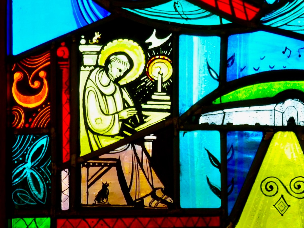
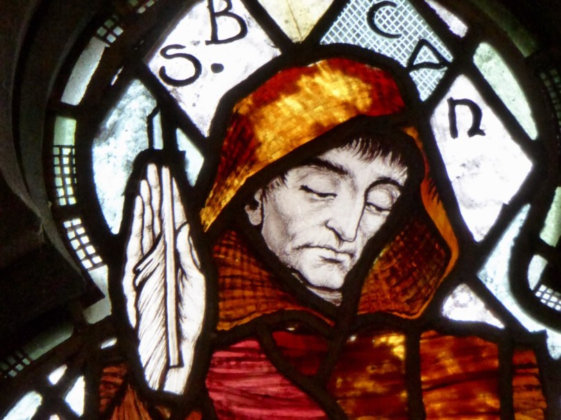
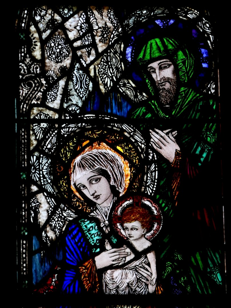
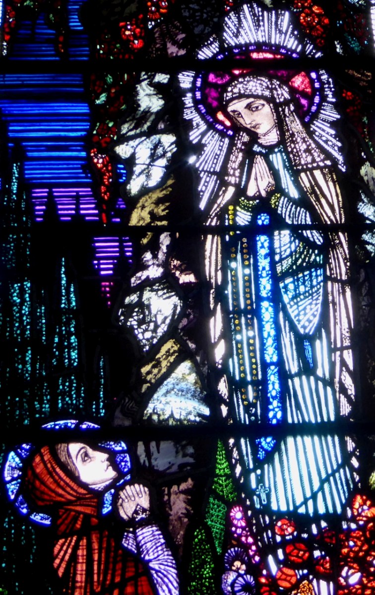
When we think of ancient Irish manuscripts we might visualise the Book of Kells, which is on display in Trinity College, Dublin. It’s remarkable to think that the Book of Lismore is over 500 years old, but that the Kells manuscript predates it by 600 years: it was created around 800AD. Here’s a scribe (from Finola’s window by George Walsh) who could be from any of those medieval periods when monks and lay brothers worked away in their scriptoriums making, copying and illuminating beautiful works which have become our most precious historical documents:
The Book of Lismore is written on vellum, and was compiled for Fínghin Mac Carthaigh, Lord of Carbery (1478–1505) and his wife Caitlín. It became known as Leabhar Mhic Cárthaigh Riabhaigh. It is entirely in Irish. What has really excited us is that, in introducing the installation of the book at Cork, UCC Professor of Modern Irish Pádraig Ó Macháin mentioned our own locality:
[The book] belongs to a period of creativity which was centred on the coastline of Cork. It is difficult to imagine those seats of learning and literature today when you look at the remote rural landscapes . . . In Rossbrin Castle – the O’Mahony stronghold – translations, treatise and journals were being made using contemporary European resources: it was a proto-university in pre-urban Ireland, paralleled by the vibrant poetic tradition of the O’Daly family in nearby Mhuintir Bháire [The Sheep’s Head] . . .
Pádraig Ó Macháin, 2020 (paraphrased)
Rossbrin (above) was only one of many castles occupied by the Gaelic nobility along the coastline here in the 15th century and beyond: this ties in with my post of last week when I explored a 1612 map and identified many centres of occupation and scholarship which surely made West Cork so vibrant and cosmopolitan in earlier times. Books are known to have originated here – including the first to be written in Ireland on paper – and some of them survive to this day.
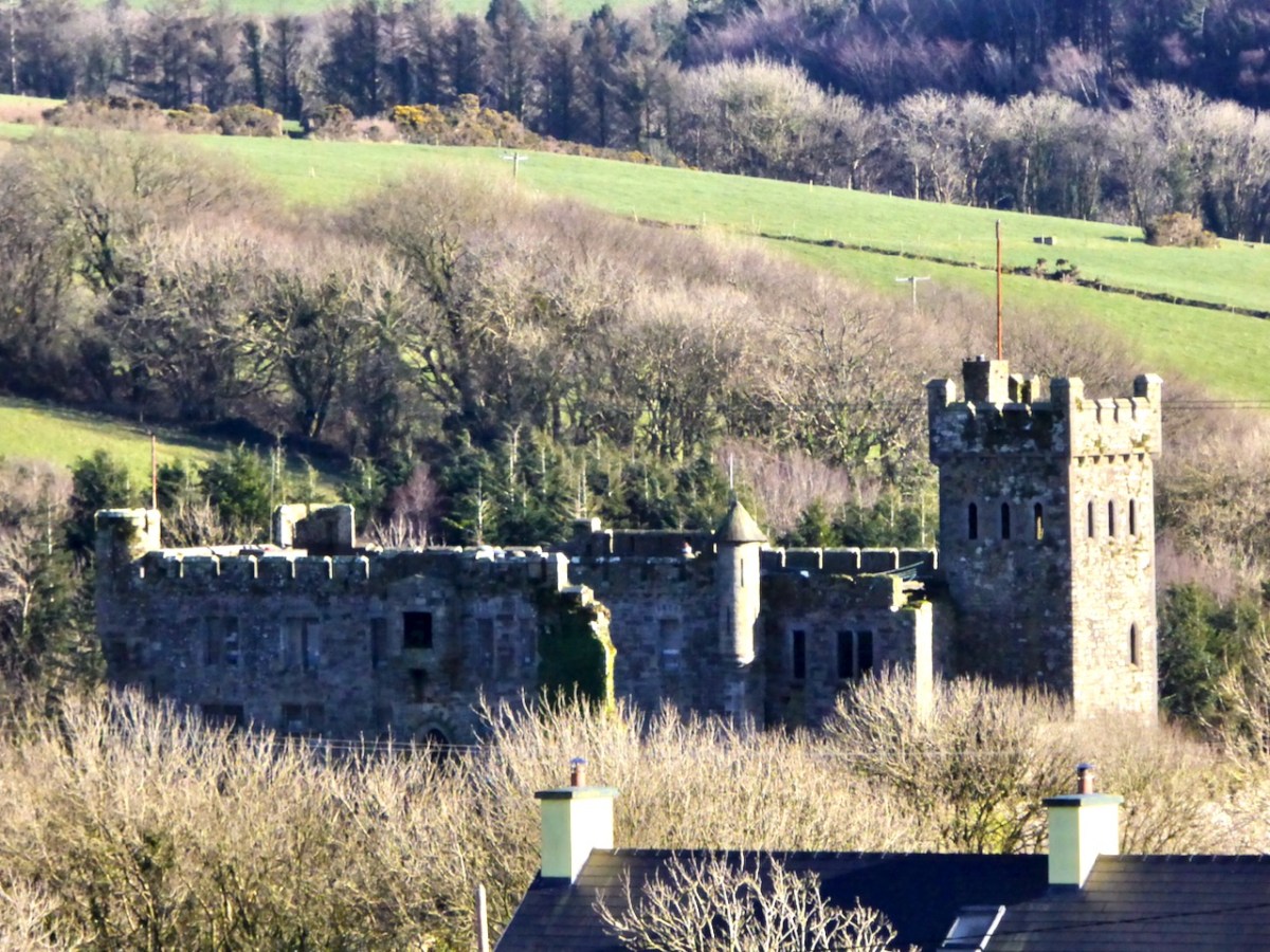
All the page illustrations in this post come from the Book of Lismore. It has a complex history and is likely to be by many hands. One – Aonghus Ó Callanáin – is certainly identified within its pages, and another – a friar named O’Buagachain is suggested. Tradition has it originating from the lost Book of Monasterboice and associates it with Kilbrittain Castle, Cork – reportedly the oldest inhabited castle in Ireland, dating from as early as 1035 and possibly built by the O’Mahonys – but also with the Franciscan Friary at Timoleague.
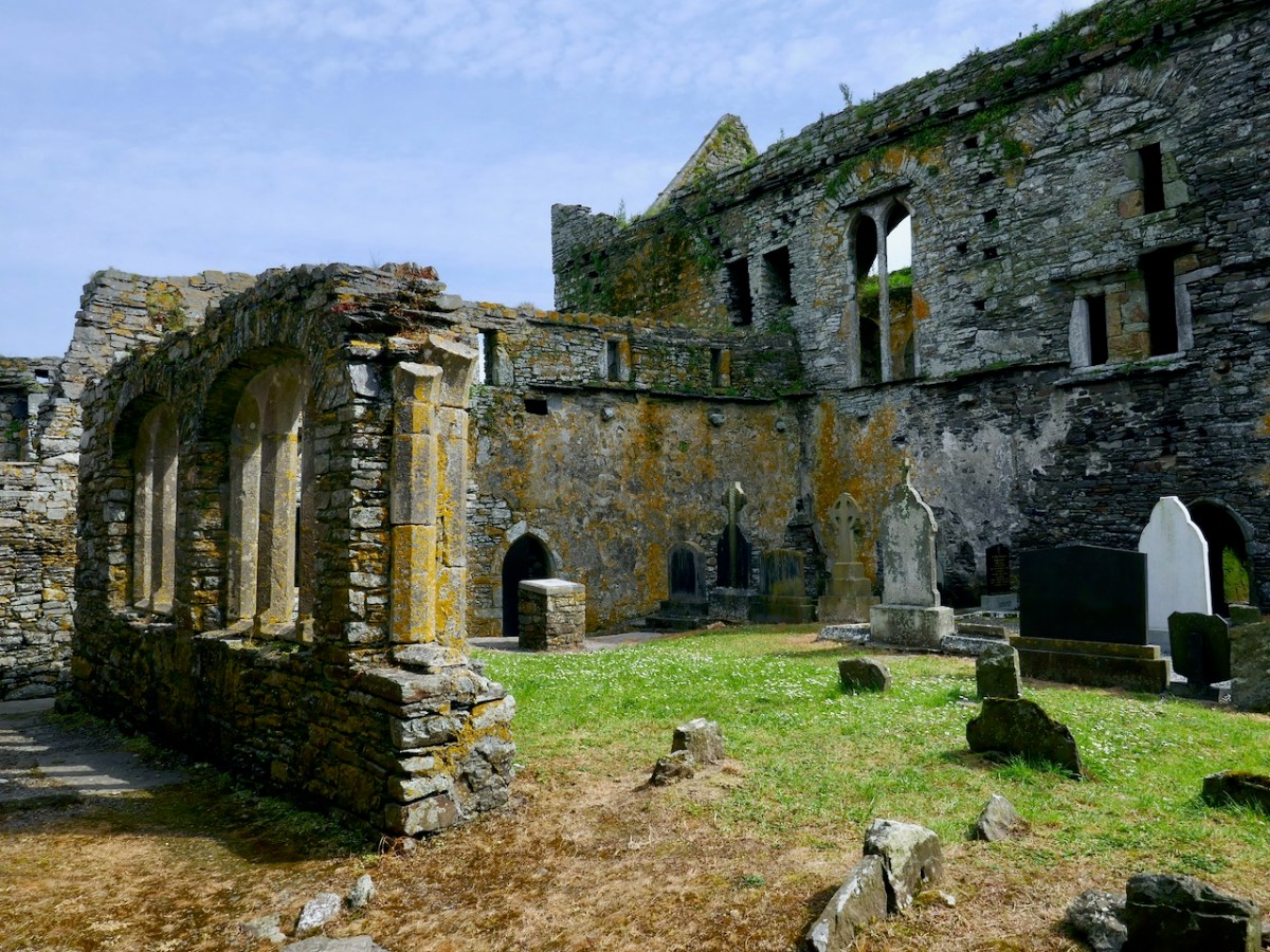
Upper – Kilbrittain castle in the present day: the original building is a thousand years old. Lower – the Friary at Timoleague, a foundation attributed to the MacCarthys in 1240, and plundered in the 17th century
The book fell into the hands of Richard Boyle, First Earl of Cork, during the Irish civil war in June 1642 and ‘vanished’ until its rediscovery in Lismore Castle in 1814. Apparently it was walled up together with the Lismore Crozier. By then the castle was owned by the Cavendishes, Dukes of Devonshire. It is this family that has donated the book to Cork and the nation, through the Chatsworth Settlement Trust.
Upper – Lismore Castle by TS Roberts, Aquatint and etching 1795 print by Samuel Alken. Lower – The Book of Lismore and the Lismore Crozier celebrated in this Celtic Revival stained glass window of St Carthage in Lismore Cathedral. The window is by Watsons of Youghal, and you can read more about them in Finola’s post here
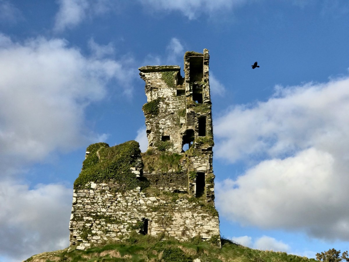
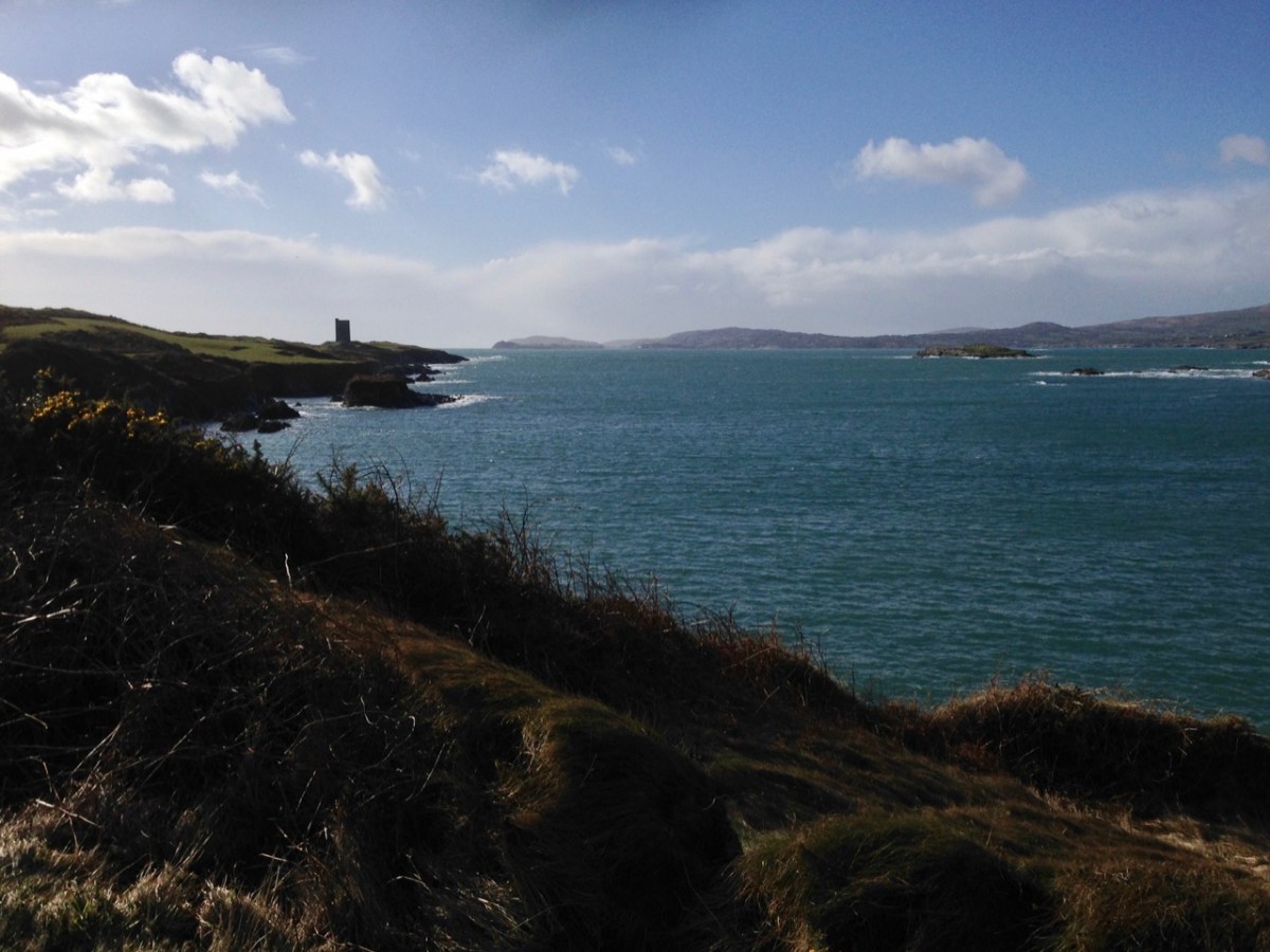
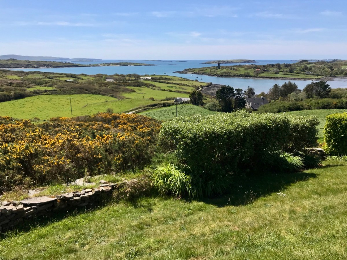
One further thought: today is ‘All Saint’s’ – November 1st. The contents of the Book of Lismore include a section on the lives of the Irish Saints: these lives were translated by Whitley Stokes in 1890 and are available to read online. Finola has used this source in her post about Saint Fanahan, or Fionnchú. We look down on Rossbrin Cove and the ruins of the medieval O’Mahony castle – sometimes described as the greatest centre of learning in Europe! We feel excitement and gratitude that here in West Cork we are linked to this treasure from that age, now in the responsible hands of UCC.
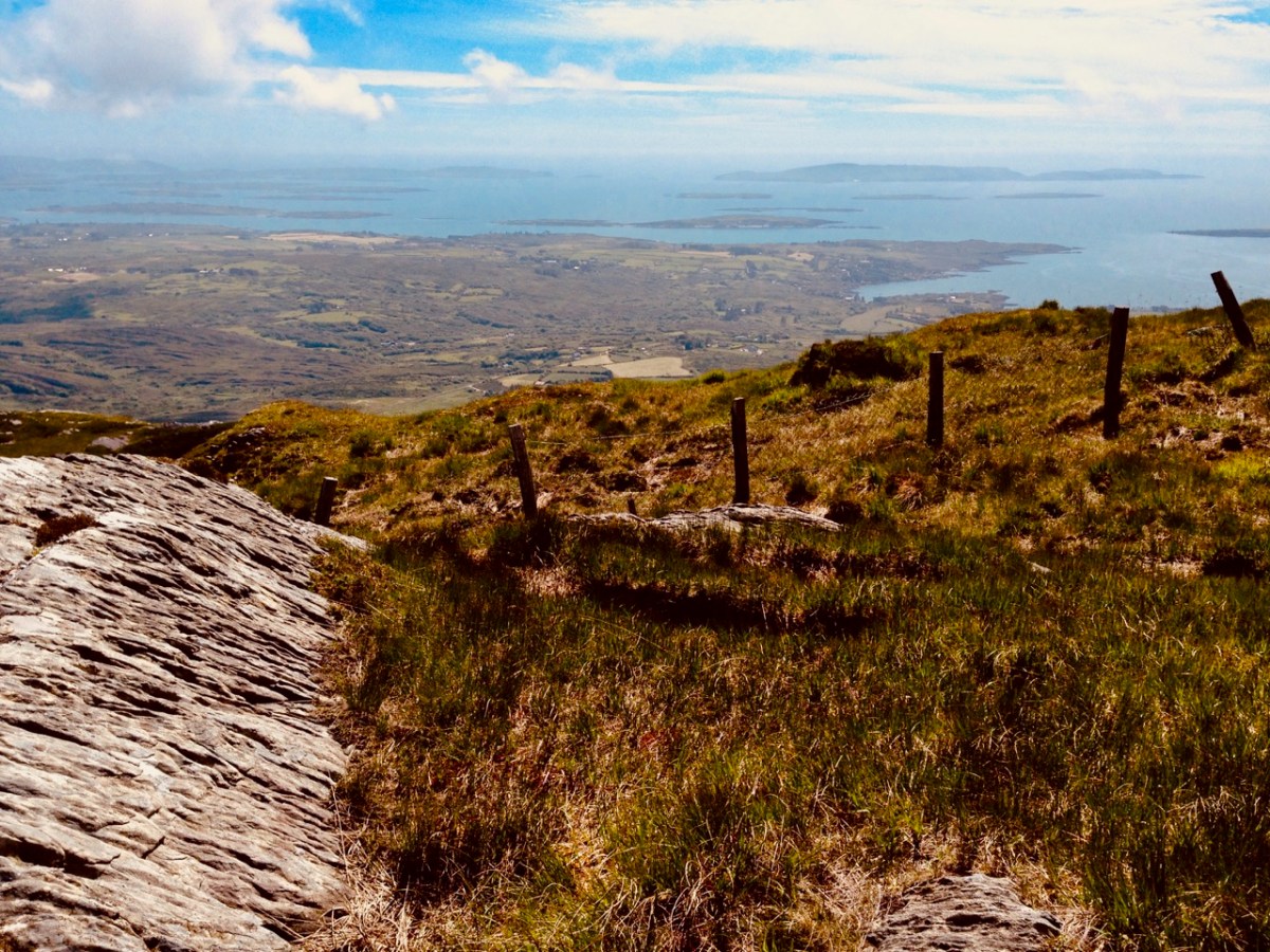
Roaringwater Bay must be so familiar to you, if you are a regular reader of this Journal. It’s a land- and sea-scape of hidden coves, inlets, islands, mountains and castles: a treasure trove for explorers and historians. That’s Black Castle at Castlepoint, Leamcon, above – said to have been built by Connor O’Mahony in the mid fifteenth century. Probably the best place to get an overview of the coastline is to climb to the top of Mount Gabriel (407m) and have a look down. You will see stretched out the archipelago of ‘Carbery’s Hundred Isles’ – seen here in autumnal hue – Cape Clear is the distant remote landfall over on the right:
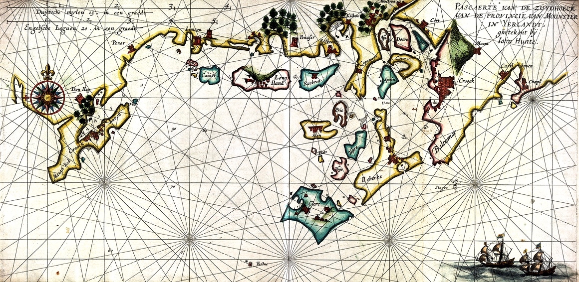
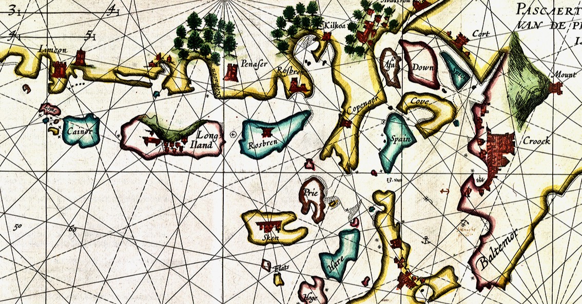
We always have a sizeable pile of books waiting to be pored over. Currently at the top is this study, The Alliance of Pirates, written by Connie Kelleher and just published (2020) by Cork University Press. We have yet to consume every detail, but we do assure you that it’s full of fascinating historical information – not just about pirates, but about life and culture in the west of Ireland in the late sixteenth and early seventeenth centuries. Connie is an ‘underwater archaeologist’ and we have followed her over many years, lecturing and presenting original information which she has gathered together on her subject. We couldn’t fail to be hooked on everything she says, illustrates and writes about, as the focus is on our own doorstep. One linchpin of this book is a map which is dated to 1612. This article from Atlas Obscura explains the map and Kelleher’s approach. It’s worth reading: note that you may be required to register on the Atlas Obscura website (it’s free) in order to access it.
The purpose of today’s post is to examine the 1612 map in detail and attempt to identify and relate to many of the places which are named and illustrated. Before that, though – let’s consider how such a chart came to be made. Finola has written previously about how West Cork as a whole was being mapped in the sixteenth and seventeenth centuries here and here. The thing that sets the 1612 map apart, however, is that it was made in secret, and largely from surveys only carried out at sea. Also, it was specifically intended to enable a Dutch fleet to assail the pirate strongholds which became numerous around the area from Baltimore to Crookhaven, centred on Roaringwater Bay and ideal for forays into the wider Atlantic trade routes.
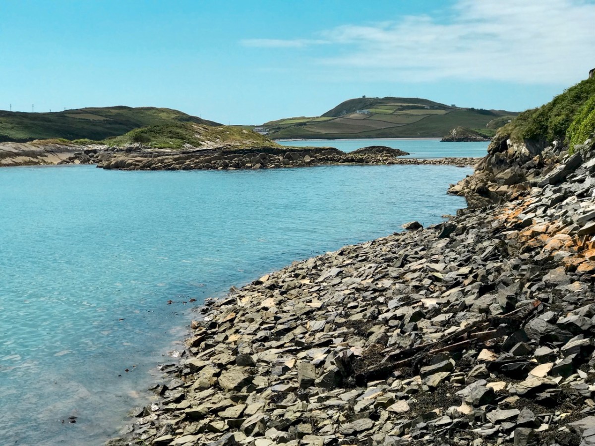
The sheltered waters of Crook Haven – an important recognised centre for careening and victualling ships operating legitimately on the Atlantic trade routes: ships that would become prime targets for the pirates based in secret ‘nests’ along the same coastline
. . . In 1612, having grown tired of the ongoing pirate harassment, the Dutch government lobbied James I for permission to enter the harbours of southwest Ireland to attack the pirates themselves. James I agreed, but only under the conditions that the pirates would be captured alive and handed over, along with captured goods, to the Kings’ ships to be transported for trial by the Admiralty in England.
To prepare their ships for the attacks, Dutch hydrographer Hessel Gerritszoon was tasked with mapping the Irish coastline with a special focus on the “pirate coast” of southwestern Ireland. A large task in front of him, Gerritszoon engaged English cartographer John Hunt to assist. . .
Atlas Obscura
The leeskarte which the hydrographers produced still exists, and has been housed since the mid 1700s in the library at the University of Göttingen in Germany, which acquired it in the mid 1700s. During her researches, Connie Kelleher travelled to Göttingen to examine and document the map, which is a wonderful resource for enlightening us on some aspects of our local history.
. . . It is a type of ‘treasure map’ informing on the heritage within the landscape at the time, which could potentially help us identify other pirate-related locations, including archaeological sites . . .
Connie Kelleher
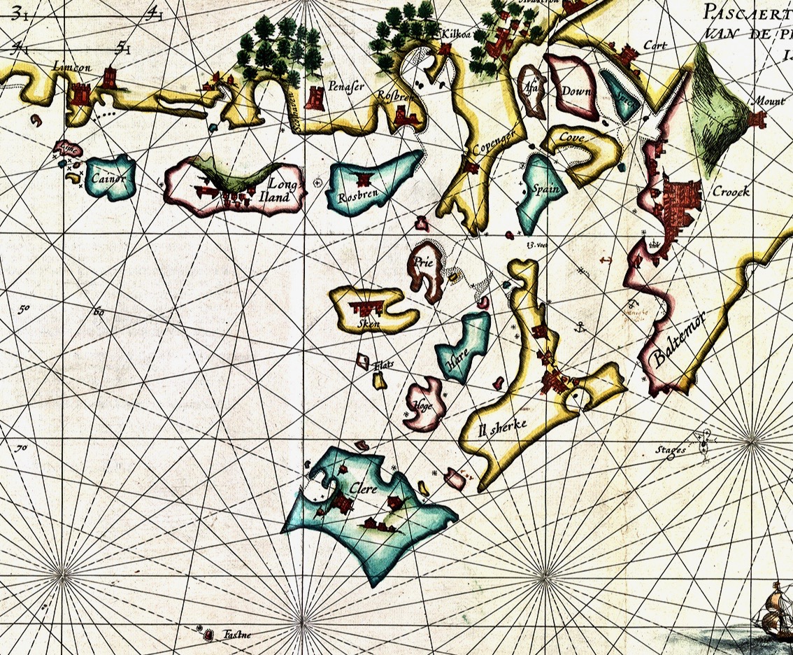
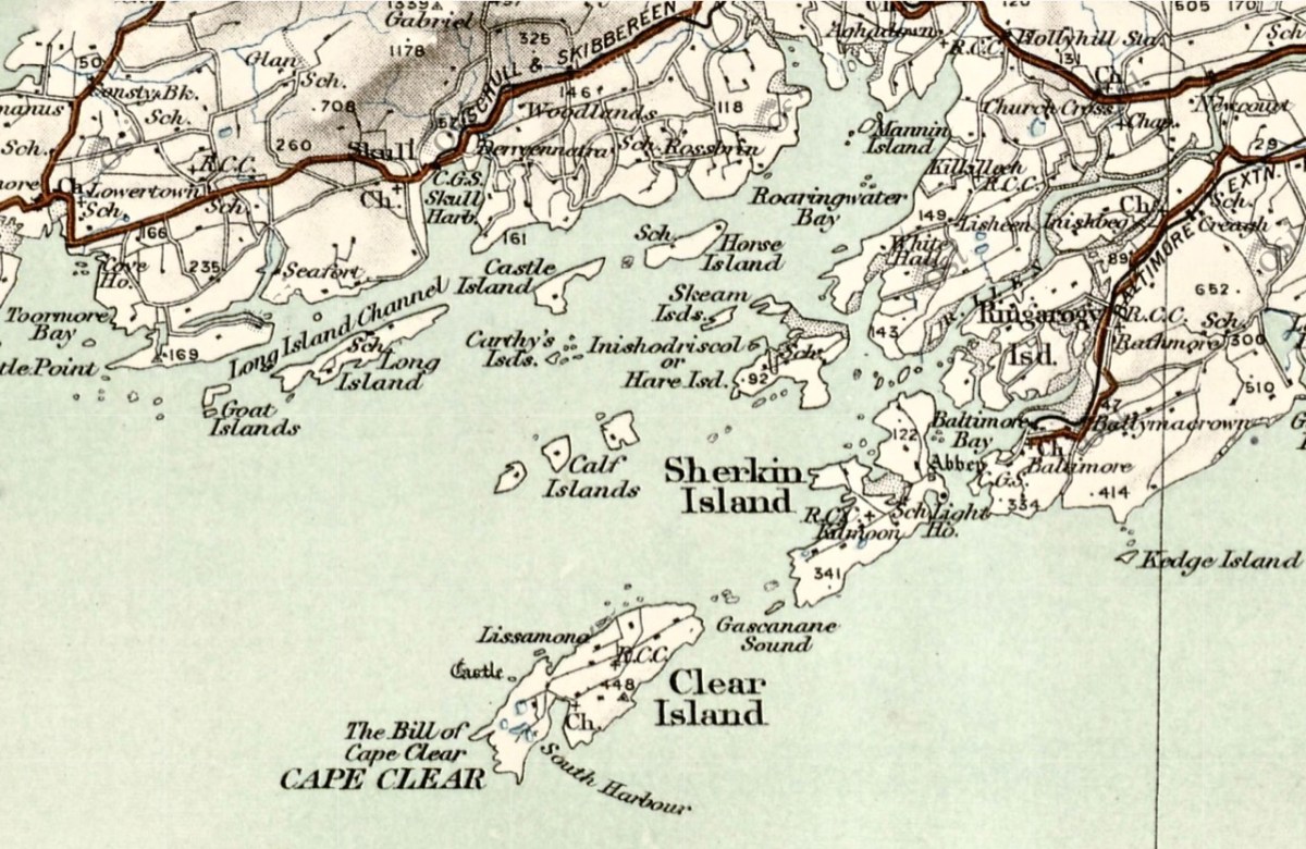
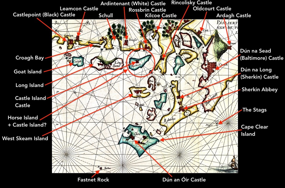
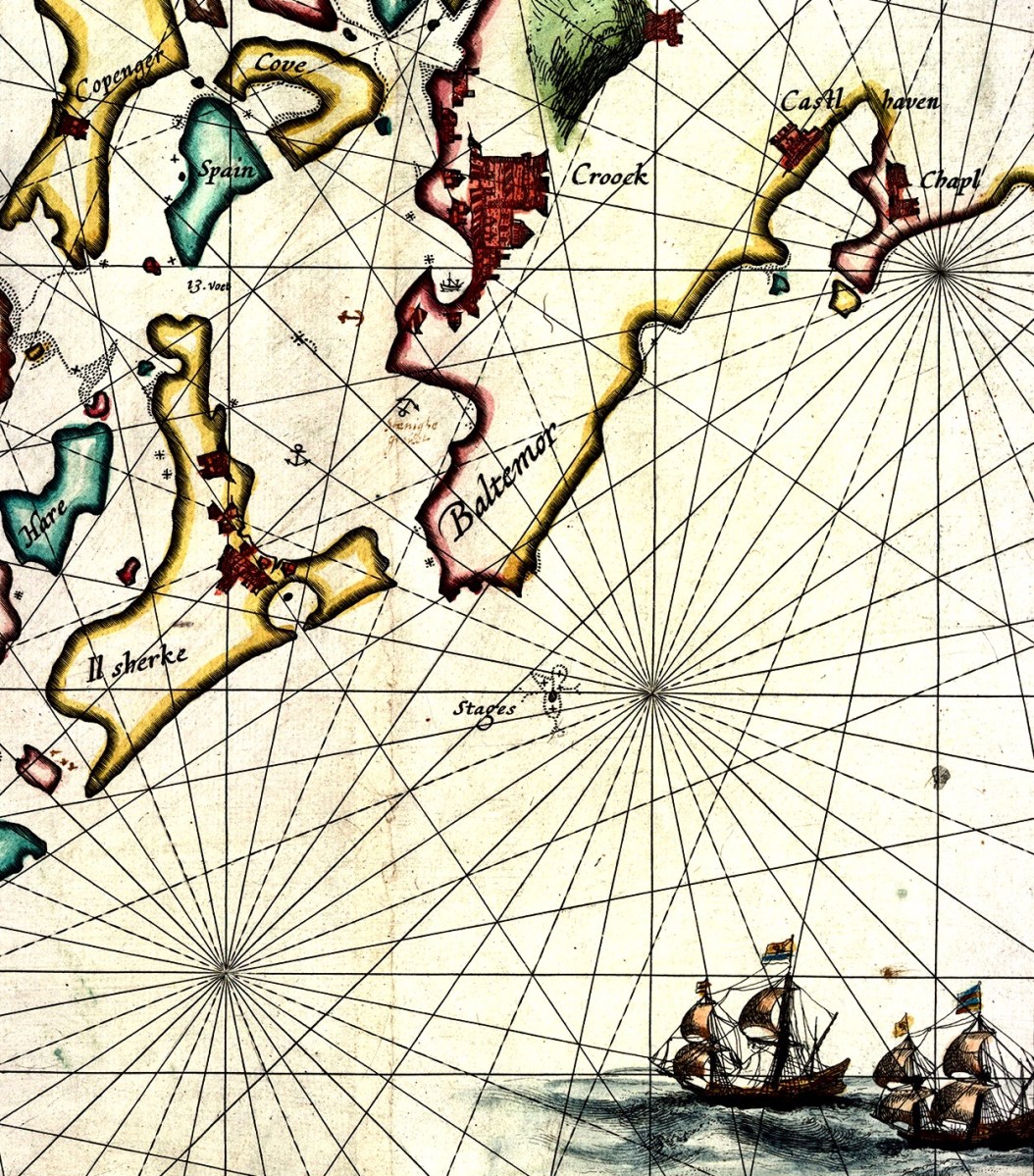
In this extract from the 1612 map I have focussed on our immediate area – the environs of Roaringwater Bay itself. Many names will ring bells with us (Clere, Baltemor, Rossbren for example); others won’t. For a simple comparison I have chosen a version of the historical 6″ Ordnance Survey map, dating from the late nineteenth century – it’s probably the clearest and best annotated example of what we would recognise around us today in terms of place-names:
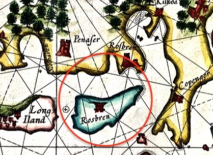
Here I have located and labelled our environs, as shown in 1612. It is remarkable that every castle and many significant features are clearly shown. Now, have a look at my red circle around ‘Horse Island + Castle Island’.
There’s an island missing! Opposite ‘Rossbren’ on the mainland is shown a single island: Rosbren. Next to it is Long Island. In fact, there are two islands here – Horse Island and Castle Island. On the 1612 map there is a castle shown on the Rosbren island, but the castle is actually on Castle Island. Somehow, the surveyors have missed this detail: perhaps the visual information which could be got offshore was confusing. What is interesting, though, is that the dotted lines at the east end of Rosbren on the 1612 map seem to mark the line of a causeway, the vestiges of which do appear today at very low tides and the feature exists in local folk memory. That level of detail on a chart, produced in the limited circumstances of its, time is remarkable! You can read more about Castle Island here.
Our view across Rossbrin Cove with its O’Mahony castle and, beyond Rossbrin Castle, Castle Island. On the left of the picture is Horse Island
I want to show you some further details from the 1612 leeskarte. Firstly, here’s a close-up of Crookhaven (Croock haven on the map). Note the scales in Dutch miles and English leagues, and ‘Limcon’ – in fact Leamcon – which was one of the major pirate centres and also the territory of Sir William Hull, a Vice Admiral of Munster from 1609. His job description involved rooting out the plague of pirates in Roaringwater Bay but in fact entailing a lot of profitable collaboration with them. Also of interest here is the depiction of Goat Island – named ‘Cainor’ and a castle – ‘Penar’ which is likely to be Ballydevlin, at the mouth of Goleen harbour; also ‘Don Hog’, which we believe refers to Castlemehigan. There is no trace remaining of either of these two.
Another detail from the map (above) shows Spain Island, Sherkin and ‘Baltemore’. the depiction of galleons in full sail is a fine ornamental ‘illumination’. Also, note the small anchor symbols. In some places on the whole map, anchorage depths are shown: another remarkable factor highlighting the observation skills of the surveyors. Additionally on this detail, note the name ‘Croock’ – Thomas Crook, an Englishman, took a lease on Baltimore Castle in 1605. The ‘Chapl’ below Castlehaven is probably the now ruined church at Myross, detailed in my post here.
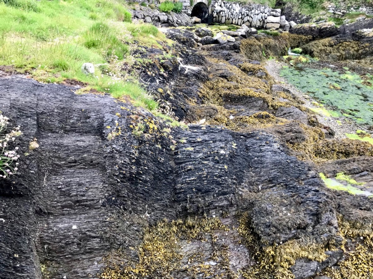
Our photograph of old (possibly ancient) steps carved into the rocks at Dereenatra. Connie Kelleher highlights the physical remains that can be found today in many of the former pirate strongholds around the coast of West Cork. Several are in the form of frequently hidden away steps and tying-up points in remote locations. I have included references to ‘pirate steps’ in a previous post. For the full picture, don’t forget to get hold of Connie’s book: it will make an ideal Christmas present for the archaeologists and pirate enthusiasts among you!
Well done to everyone who took part and I hope you enjoyed it. (And it’s not too late – you can always try the Quiz, if you haven’t already done so, before proceeding.) It wasn’t easy. In fact, if I had tried to answer it myself, as opposed to setting it, I don’t think I would have got them all right. That’s important, as it illustrates the very conundrum posed by the question of what is, in fact, a genuine Harry Clarke, designed by him and either at least partially executed by him or executed under his very close supervision, as opposed to a Harry Clarke Studios, that is one done by other artists working in his studio, especially after his death. I hope you remember your answers, as the poll only tells me the percentage of people who answered correctly. OK – here goes.
Saint with Hood 1
Yes: 70% No: 30%
Correct Answer: Yes
In fact it was designed and totally executed by him. It depicts St Fachtna, Patron Saint of Rosscarbery, and is a detail from the 1919 Nativity at St Barrahane’s Church of Ireland in Castletownshend, West Cork. The window was commissioned by Edith Somerville and her siblings in memory of their parents and was one of Harry’s first private commissions after he burst on the scene with his triumphal set of windows for the Honan Chapel at University College, Cork. Harry was still trying to find his feet as a stained glass businessman at this point with the artist in him taking precedence over the need to make money at this. He lavished such care and attention on this window that his father, Joshua Clarke, despaired of their ability to recoup what it was costing. In the end he and Harry had to come to an arrangement whereby Harry paid for workshop time and the use of his father’s glaziers. It was an important lesson in the need to balance his drive as an artist with making a living and led to his taking on assistants and artists to help him with the volume of work. To see the whole window, take a look at my post The Nativity – by Harry Clarke.
Saint with Hood 2
Yes: 33% No: 66%
Correct Answer: No
Two thirds of you knew at once that this is not a Harry Clarke – in fact, it isn’t even a Harry Clarke Studios. This is the head of St Colman from the Honan Chapel, but it is not one of the 11 windows that Harry supplied, but rather one of the windows done by An Túr Gloine (The Tower of Glass), the cooperative studio established by Sarah Purser and Edward Martyn to promote the use of Irish windows by Irish artists. Read more about An Túr Gloine in this post: Loughrea Cathedral and the Irish Arts and Crafts Movement. The St Colman window was the work of A E Child, who mentored many of the Túr Gloine artists and who taught Harry at the Dublin Metropolitan School of Art.
Nativity 1
Yes: 80% No: 20%
Correct Answer: No
Four out of every five of you thought this was a Harry Clarke, but in fact this was the work of one of the Harry Clarke Studios artists, probably in the period immediately following Harry’s death, when there was pressure on them to produce Harry look-alikes. The window, which is very difficult to photograph, is high up in the wall of a transept in St Patrick’s Church in Wicklow Town. I think this is one I would have identified as a Harry Clarke, as it is such a close reproduction of his style.
Nativity 2
Yes: 58% No: 42%
Correct Answer: Yes
Yes, this is indeed a Harry Clarke. However, it’s not as straightforward as the Nativity window described in Saint with Hood 1, above, in which every aspect of the project was the work of Harry himself. It’s one of the collection of windows in the Diseart Centre in Dingle, in what was formerly the Presentation Convent. These windows were commissioned in 1924. Nicola Gordon Bowe assigned a status of Harry Clarke (B) to this one, that is ‘initially conceived and designed by him but executed by his Studio under his close supervision’. She wrote:
At the beginning of 1924 Harry Clarke was at the peak of his career, in both stained glass and illustration. However, his health was beginning to deteriorate, among the causes being the extreme pressure of work, the extra responsibility his father’s death had put on him, and the upheaval in his life caused by the reconstruction of the Studios and the conversion of the two extra houses acquired in North Frederick Street. . . He engaged Austin Molloy to help him with cartoons, probably those required for a series of windows illustrating The Life of Christ at the Presentation Convent, Dingle. . . Although the Studios were responsible for most of the work on the Dingle windows. . . this series of six pairs of lancets is notable for some passages either worked or directed by himself. These include the sensitively painted head of the oldest king in the Nativity light. . .
In The Nativity – by Harry Clarke, you can see the whole window and a detail of the three kings. Five years after he had expended such personal concentration on the Castletownshend Nativity, Harry was under so much pressure from incoming orders that he could no longer handle all the work himself. By this time he had employed a small but brilliant contingent of assistants and artists and rigorously trained them to reproduce his style and bring his designs to fruition.
Presentation
Yes: 38% No: 62%
Correct Answer: No
This is a detail from an enormous Harry Clarke Studios Window in St Mel’s Cathedral in Longford, installed in 1932, after Harry had died. The Cathedral burned down on Christmas Day 2009 but was rebuilt and the windows were wonderfully restored by Abbey Stained Glass Studios for the 2014 re-opening. If you search online for ‘St Mel’s Cathedral stained glass’ most of the results will simply refer, erroneously, to ‘the Harry Clarke windows’. The scene of the Presentation is in the predella (lowest panel) of the St Anne window.
St Augustine
Yes: 53% No: 47%
Correct Answer: No
This depiction of St Augustine is in the Holy Cross Catholic Church in Charleville, Co Cork, which is packed with interesting stained glass, including a series of twelve from Joshua Clarke and Sons erected between 1919 and 1922. Harry was working in his father’s studio at the time, doing his own windows and also assisting with the supervision of work under his father’s imprint. In a letter to Holy Cross, Joshua says, “Harry will look to the new windows and see you get very good ones.” And they are good, but the only one that looks (to me, that is) like Harry took an active hand in it is this one of St Augustine. It has the large expressive eyes, sensitive mouth, compassionate expression and long tapering fingers that we see in the full development of his style. I suspect that’s what those of you who answered Yes were responding to. However, it cannot be called a Harry Clarke, or even a Harry Clarke Studios – instead, it bears the stamp of J Clarke and Sons and remains an interesting question.
Crucifixion
Yes: 52% No: 48%
Correct Answer: No
A round window above the altar in Ballydehob Church in West Cork. While the style is reminiscent of the windows produced by the HC Studios after Harry died, in fact this window is by Earley and Co, and specifically by Leo Earley. Leo was very inspired by Harry and emulated his use of colours and his embellishments and decoration. While the faces and figures in this window are not convincing, the flow of the ornate garments are an echo of the fantastical and imaginary faux-medieval costumes Harry loved.
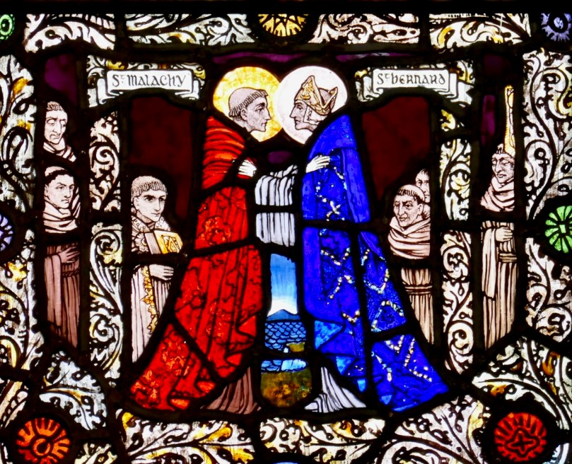
Malachy Meets Bernard
Yes: 48% No: 52%
Correct Answer: Yes
The predella from the right hand light of a three light window, this small scene show St Malachy meeting his mentor, St Bernard. Of the three lights, the St Bernard and St Rita windows are by Harry Clarke and the central light is by William McBride. They date to 1924 and are in the Sacred Heart Church in Donnybrook, Dublin.
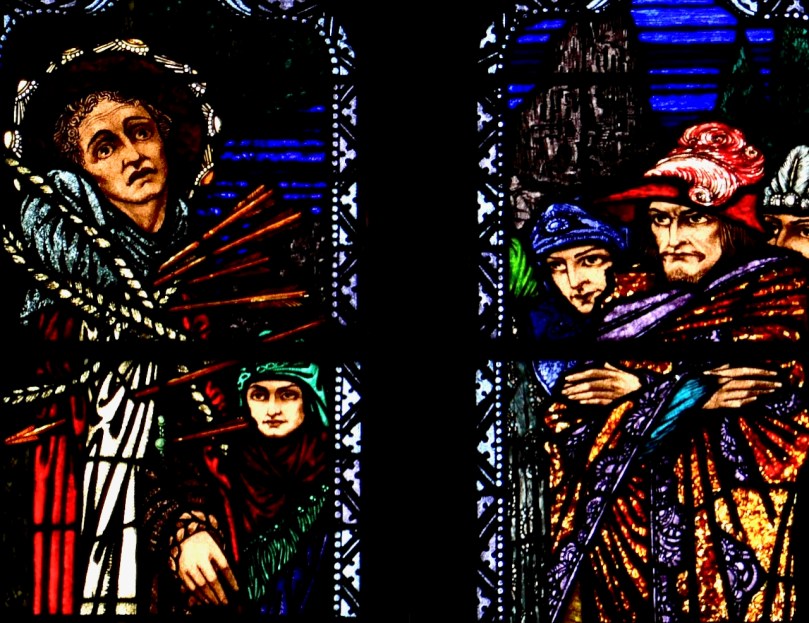
St Sebastian
Yes: 71% No: 29%
Correct Answer: No
John the Baptist Church in Blackrock, South Co Dublin, is full of interesting stained glass, including an Evie Hone. There are several windows by the Harry Clarke Studios and the St Sebastian is one of them. This is one I would have voted yes to myself, as the faces of the onlooking soldiers are so Harry Clarke.
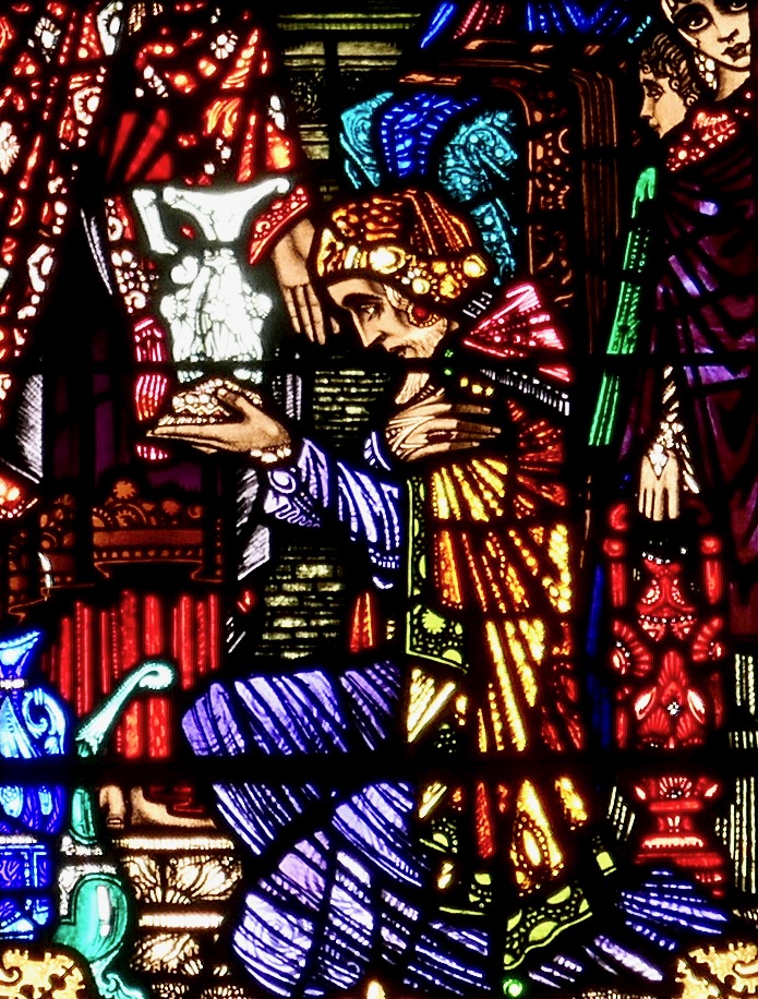
Scene from Wedding Feast at Cana
Yes: 80% No: 20%
Correct Answer: No
Although officially this is not listed as a Harry Clarke window, you can certainly be forgiven for thinking it is, as everything about it shouts Clarke, including the sheer richness of detail. In fact, this window was one of the last to be worked on on his studio while he was still alive (although mostly absent at a sanatorium in Davos, Switzerland) and he did indeed have some input (although we don’t know how much) into the design of parts of the window, including this scene. It is a detail from one of three lights, which together incorporate seven Scenes from theLife of Christ in the Catholic Church in Timoleague, West Cork. The whole window is very fine indeed and I will be writing a future post about it as it is the subject of some excellent research by Clarke scholars, and a good example of the complexities of ascribing the label ‘Harry Clarke’.
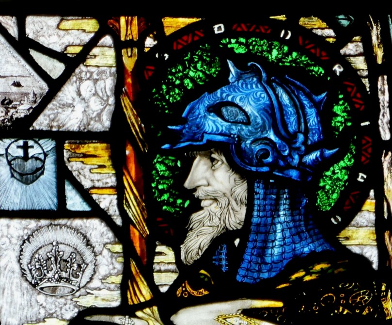
Saint with Helmet
Yes: 61% No: 39%
Correct Answer: Yes
No ambiguity here – this is the head of St Adrian from the O’Keefe Memorial Window by Harry Clarke in the Church of the Assumption, Wexford. You can view the full window and read more about this window in my post That He Might Better Rest. Harry designed and executed this window in 1918/19 having first travelled to Wexford to meet with the fallen soldier’s grieving mother.
Lourdes Apparition
Yes: 56% No: 44%
Correct Answer: Yes
I might have been tempted to say no to this one as I find it ultra-conventional, but it is indeed a Harry Clarke, designed by him and executed under his supervision. It is one of two windows in a small country Church in Duhill, Co Tipperary. The other window is a startling contrast to the piousness of this one but I will leave that discussion for another day.
Patrick at Slane
Yes: 34% No: 66%
Correct Answer: No
Good eye! This image is a detail from the huge Patrick window in the Church of Sts Peter and Paul in Athlone and it’s by Richard King, done in the Harry Clarke Studios in 1937 several years after Harry died. It’s unusual for any HC Studios window to be signed – that’s part of the difficult of identifying which of the Studios artists worked on their windows – but in this case we do know that Richard King made several of the Athlone windows. Read more about those windows in my post Discovering Richard King, where you will also find a link to images of all the Athlone windows.
Brendan the Navigator
Yes: 68% No: 32%
Correct Answer: Yes
This is the head of Brendan the Navigator from the Honan Chapel series which propelled Harry Clarke into the forefront of Irish design when they were installed in 1916.
So – how did you do? Want to argue about any of the answers?
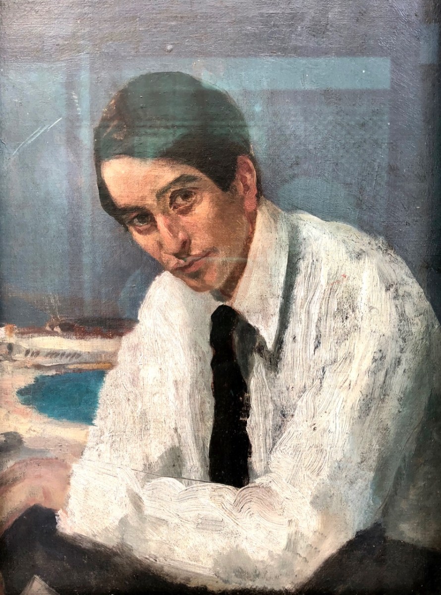
A stained glass window can be labelled a Harry Clarke if it was designed and executed entirely by him, if it was designed and partially executed by him, or if it was designed by him and the execution done under his close supervision. The portrait above was done by his wife, Margaret Crilly Clarke, in 1914 when Harry was only 25 and not yet plagued by the consumption that was to carry him off in 1931 at only 41 years of age. For the last few years of his life, Harry was increasingly hampered by illness, and also busy with illustration work. He employed a very talented group of artists to execute windows of his design and trained them rigorously to reproduce his unique style, for which there was a huge demand. After his death, those same artists continued to work in the Harry Clarke Studios and to produce windows in that style because that’s what people wanted, and so it can be difficult to know whether a window is a true Harry Clarke or a Harry Clarke Studios. For some windows, only research in the extensive Studios archives (housed at Trinity College) can establish the answer for certain. There are excellent reasons to be proud of many Studios windows, and it shortchanges the outstanding artists who worked on them if we keep insisting that everything was done by Harry himself. I want to explore this topic further, but I’d like to start off with a quiz to see if we’re as good as we think we are at recognising a Harry Clarke from a non-Harry Clarke. So polish up your glasses and take the quiz! Answer YES if you think this is a Harry Clarke (according to my definition) and NO if you believe it is not. I might even have thrown in the odd image that is neither Harry Clarke nor Harry Clarke Studios. Answers next Sunday.
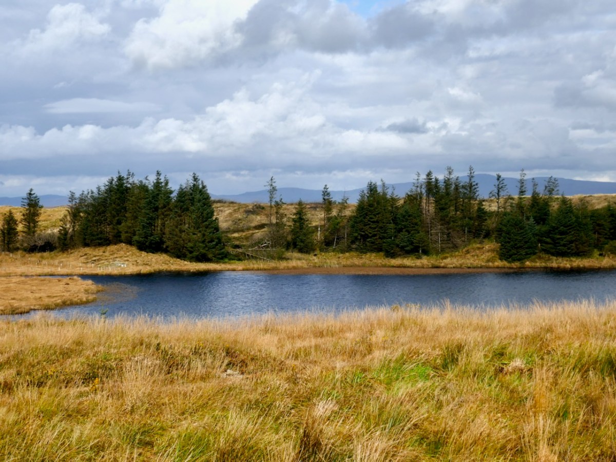
We set out to search for a lake in the hills above Ballybane West: it’s known as Constable Lake. There’s a story, of course – which I found in the Duchas Schools Folklore Collection, collected at Corravoley School in 1937. A whole gamut of stories, in fact, packed into two neatly handwritten pages. I don’t think I have ever found quite so much information on local lore in a single entry. Ammunition for a few more posts, perhaps!
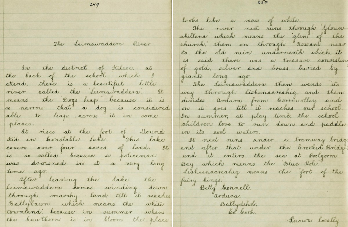
In the district of Kilcoe, at the back of the school which I attend, there is a beautiful little river called the “Leimawaddera”. It means the “Dog’s Leap” because it is so narrow that a dog is considered able to leap across it in some places.
*
It rises at the foot of Mount Kid in Constable Lake. This lake covers over four acres of land. It is so called because a policeman was drowned in it a very long time ago.
*
After leaving the lake the Leimawaddera comes winding down through marshy land till it reaches Ballybawn which means the ‘white townland’, because in summer when the hawthorn is in bloom the place looks like a mass of white.
*
The river next runs through ‘Glounakillena’ which means the “glen of the church”, then on through Rossard near to the old ruin underneath which it is said there was a treasure consisting of gold, silver and brass buried by giants long ago.
*
The Leimawaddera then wends its way through Lishenacreahig, and then divides Ardura from Corravolley and on it goes till it reaches our school. In summer, at play time, the school children love to run down and paddle in its cool waters.
*
It next runs under a tramway bridge and after that under the Crooked Bridge and it enters the sea at Poolgorm Bay which means the “Blue Hole”.
*
Lisheenacreahig means the “fort of the fairy kings”.
This view is cleverly framed to minimise the clues, but several readers gave the correct answer almost immediately. Here’s a more revealing picture:
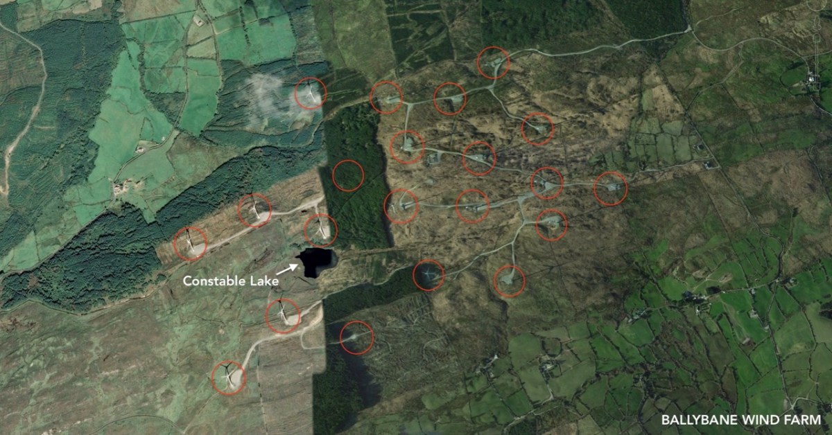
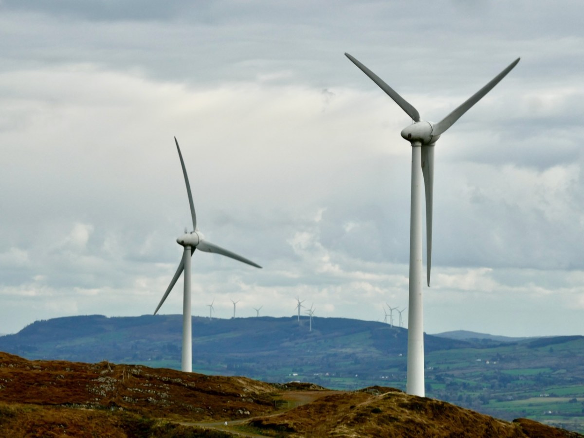
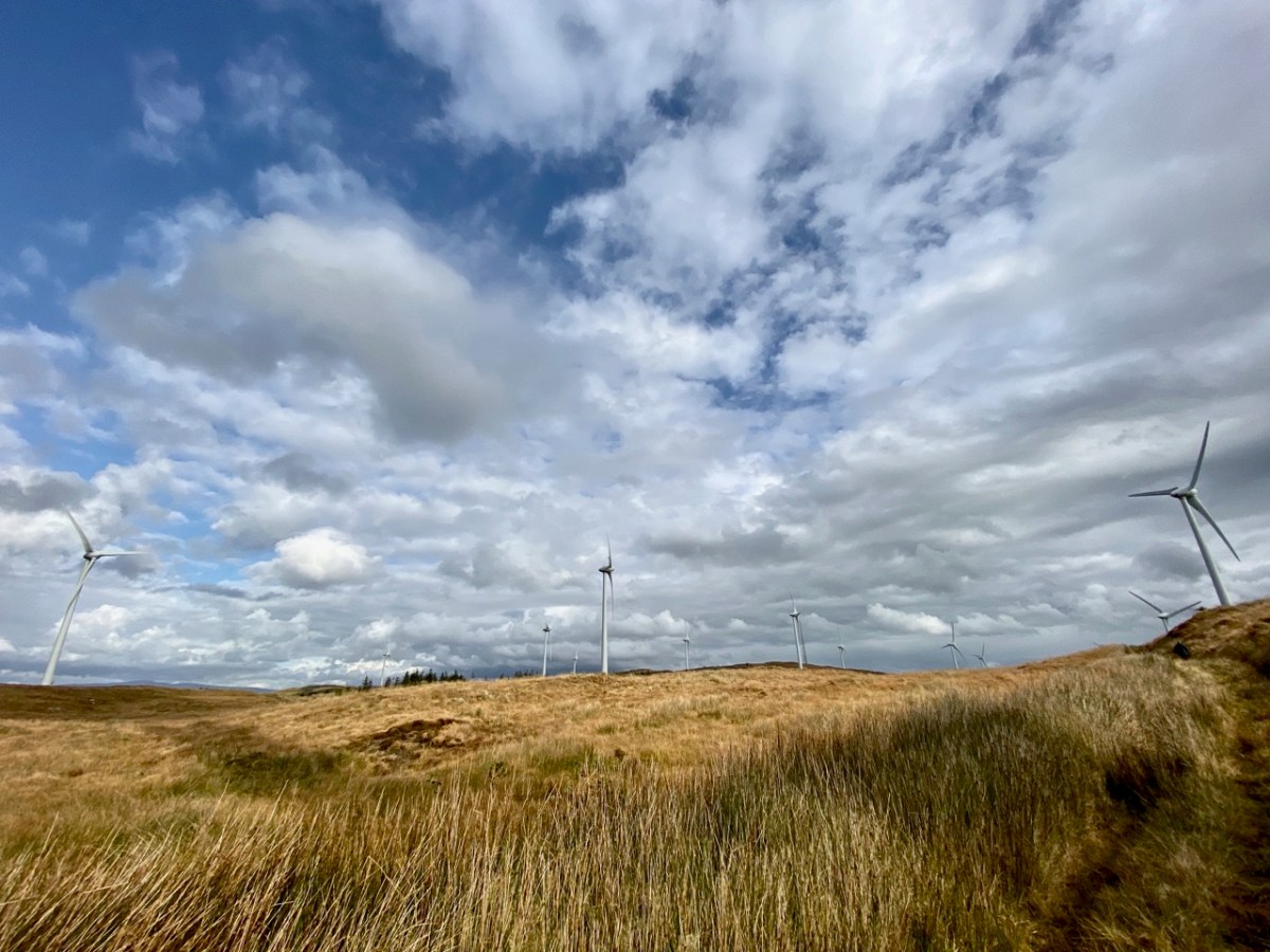
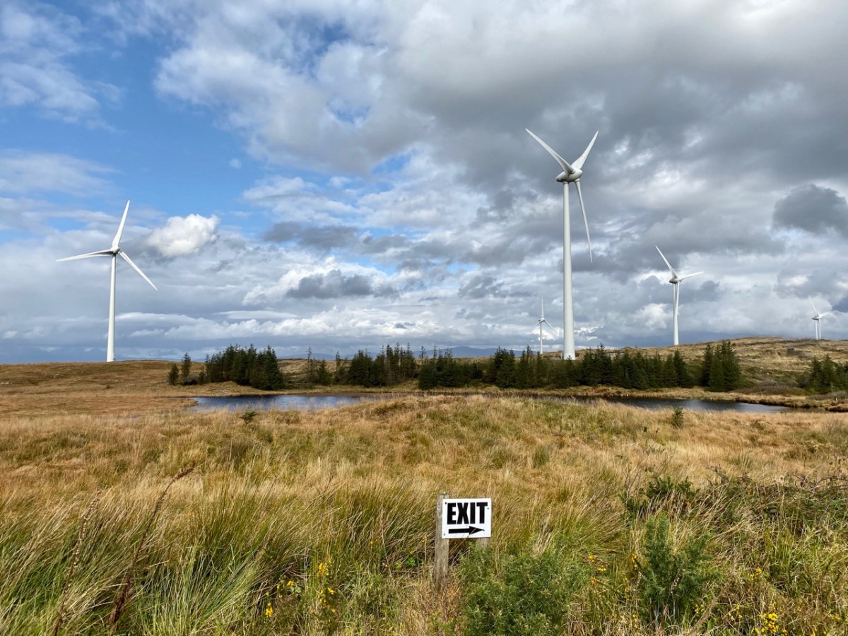
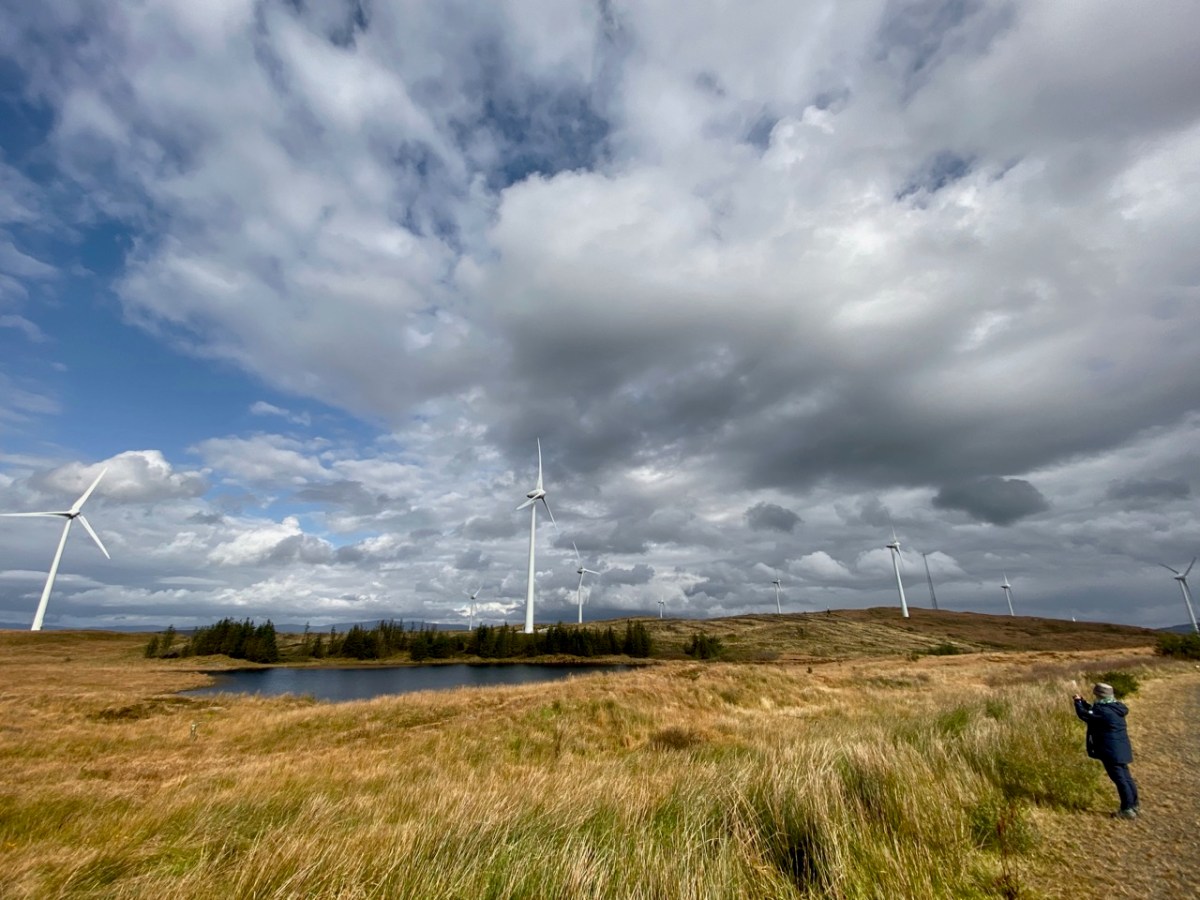
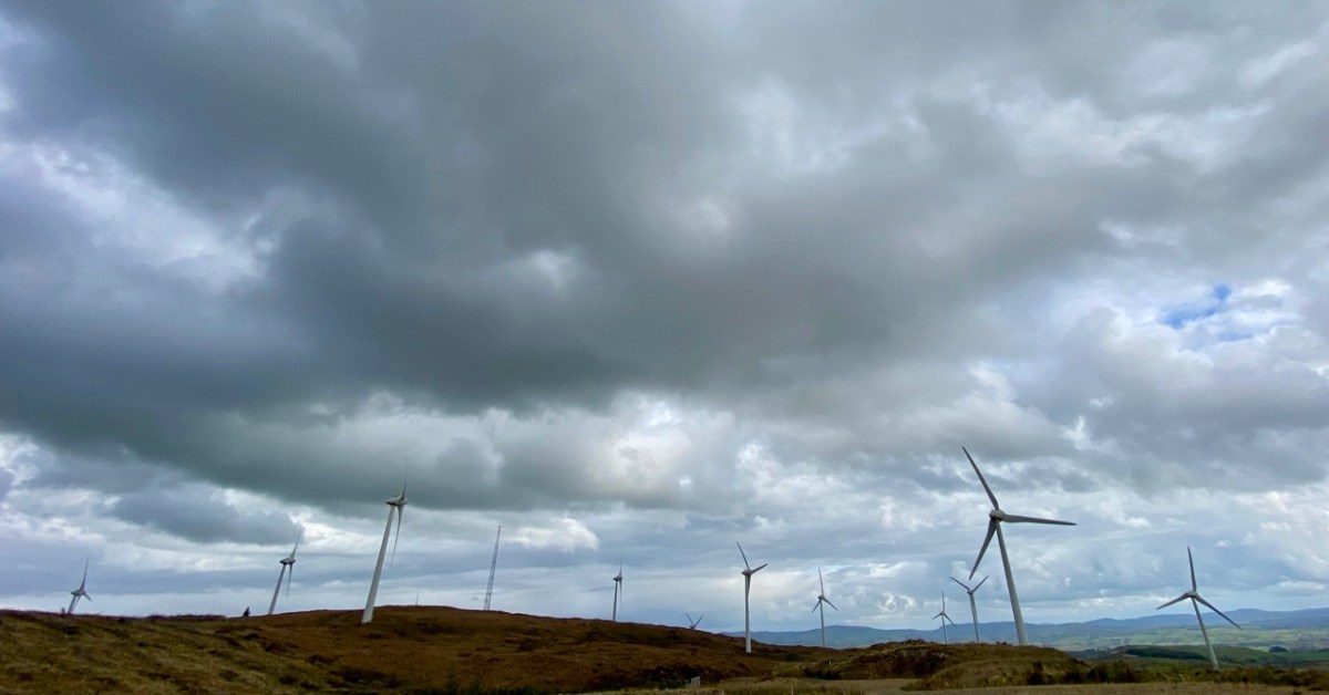
Constable Lake now lies within the boundaries of Ballybane Wind Farm and the 21 tall turbines can all be seen from its shores. It’s one of several farms in the West Cork area, strategically sited on the wild heathland ridges, working away at their mission of harvesting nature’s resources in order to provide us with electricity without burning fossil fuels.
Upper – on the aerial view I have marked each of the 21 turbines. Lower – from the Ballybane site the turbines at Drinagh and Coomatallin are visible
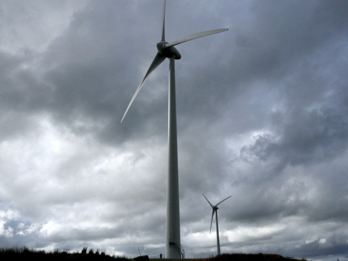
I find the turbines dynamic and exhilarating. I know there are many readers who will disagree with my opinion, and social media abounds with polarised views about them from all perspectives. It’s hard to home in on hard and fast truths on anything these days but I have read extensively – and scientifically – on the subject and it seems to me that these wind-turned appliances have a life expectancy of around 25 years, and they pay for their installation in less than two years. Of course, carbon emissions are involved in the construction and manufacturing processes but this is heavily outweighed by the carbon savings from running these instead of burning fossil fuels to produce our electricity. Dismantling costs are built in to the permissions, and there is no doubt in my mind that in 25 years time – or less – technology will have advanced towards other solutions.
A simple chart from 2017 (via FactChecking.org) which graphical shows how well onshore wind farms perform against other fuel sources. Only nuclear power is marginally better
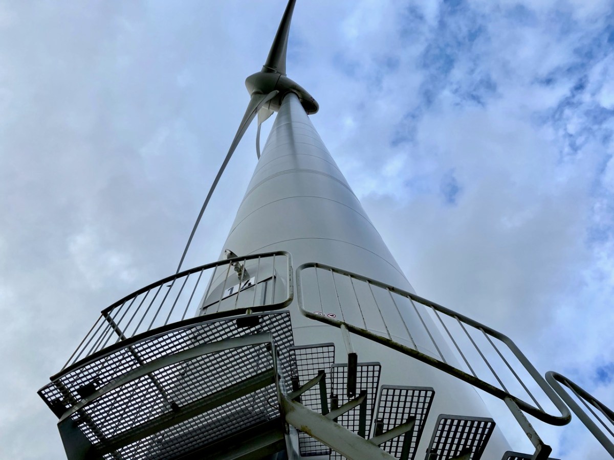
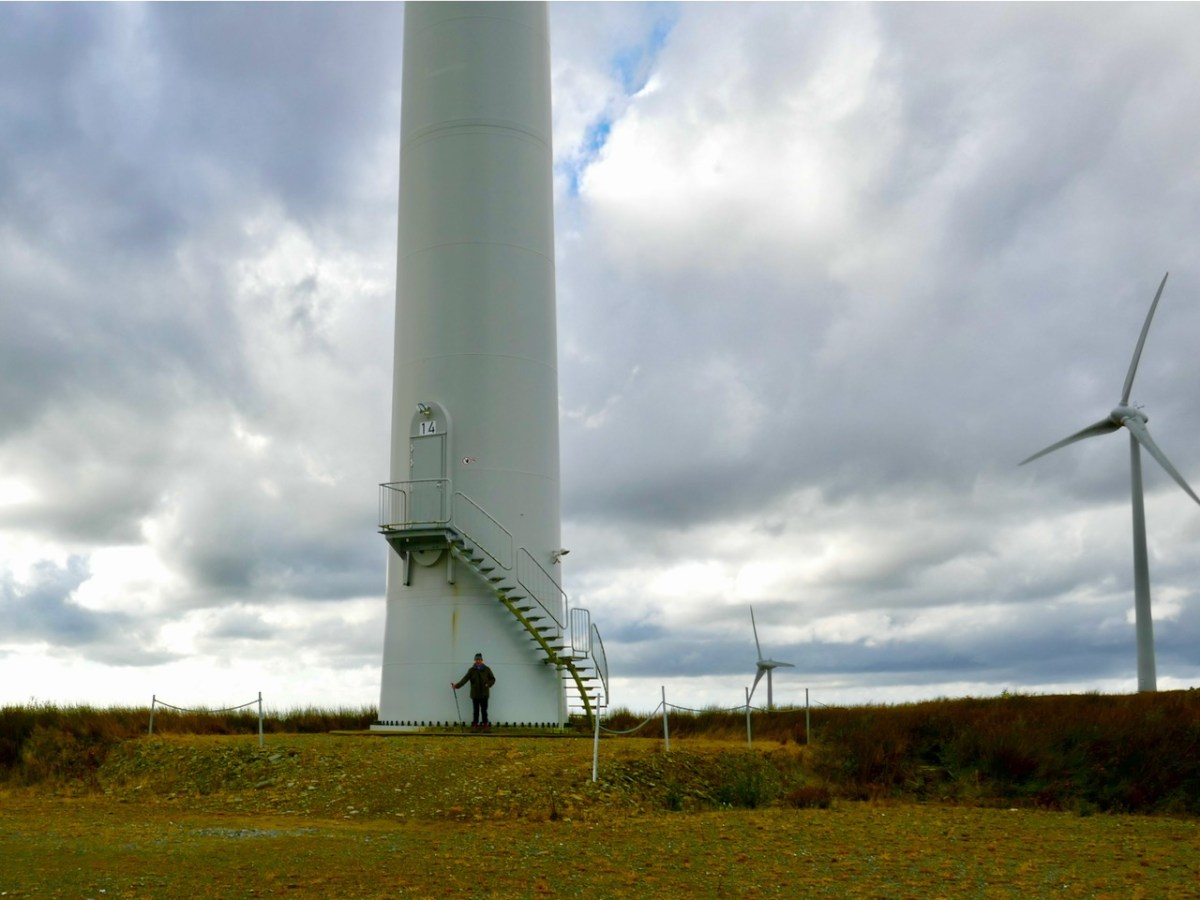
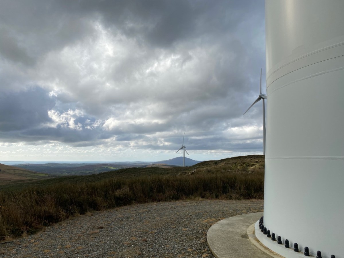
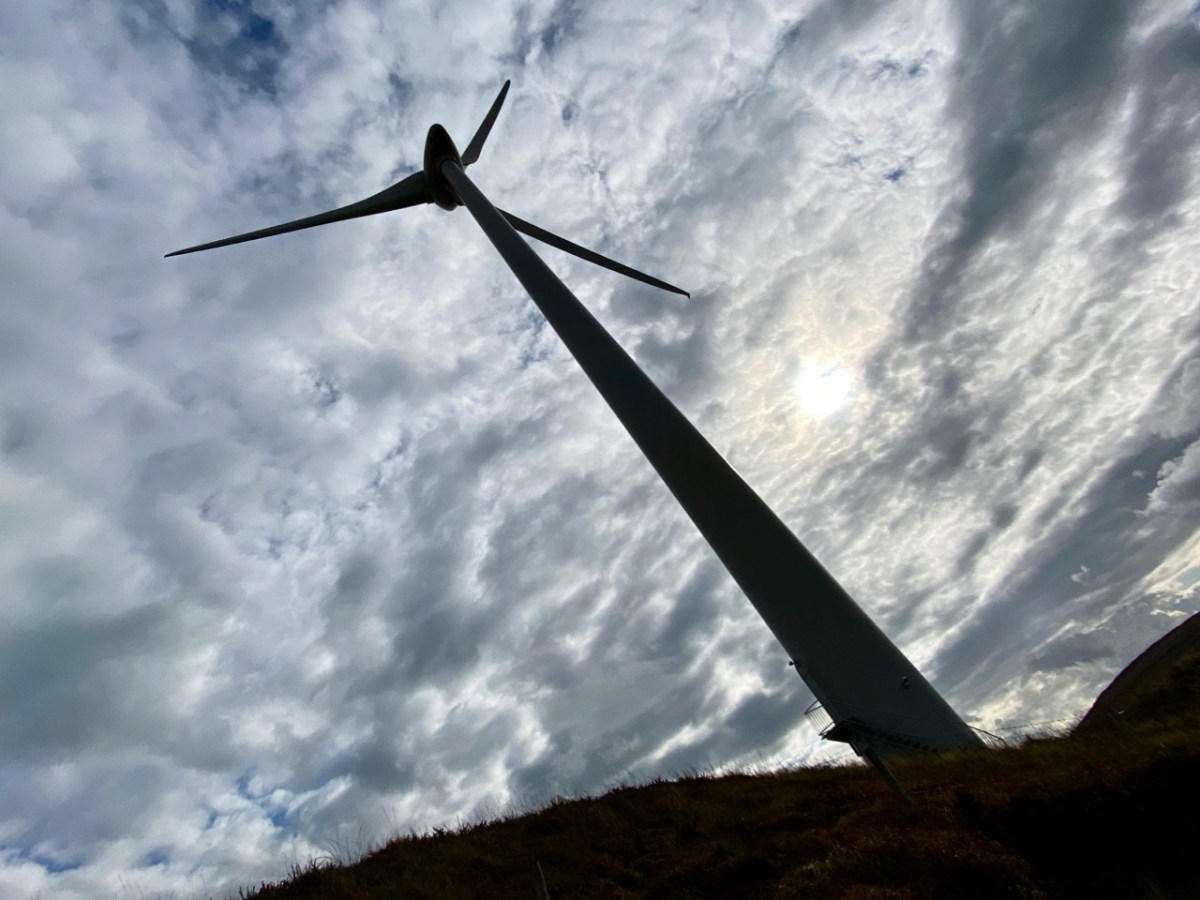
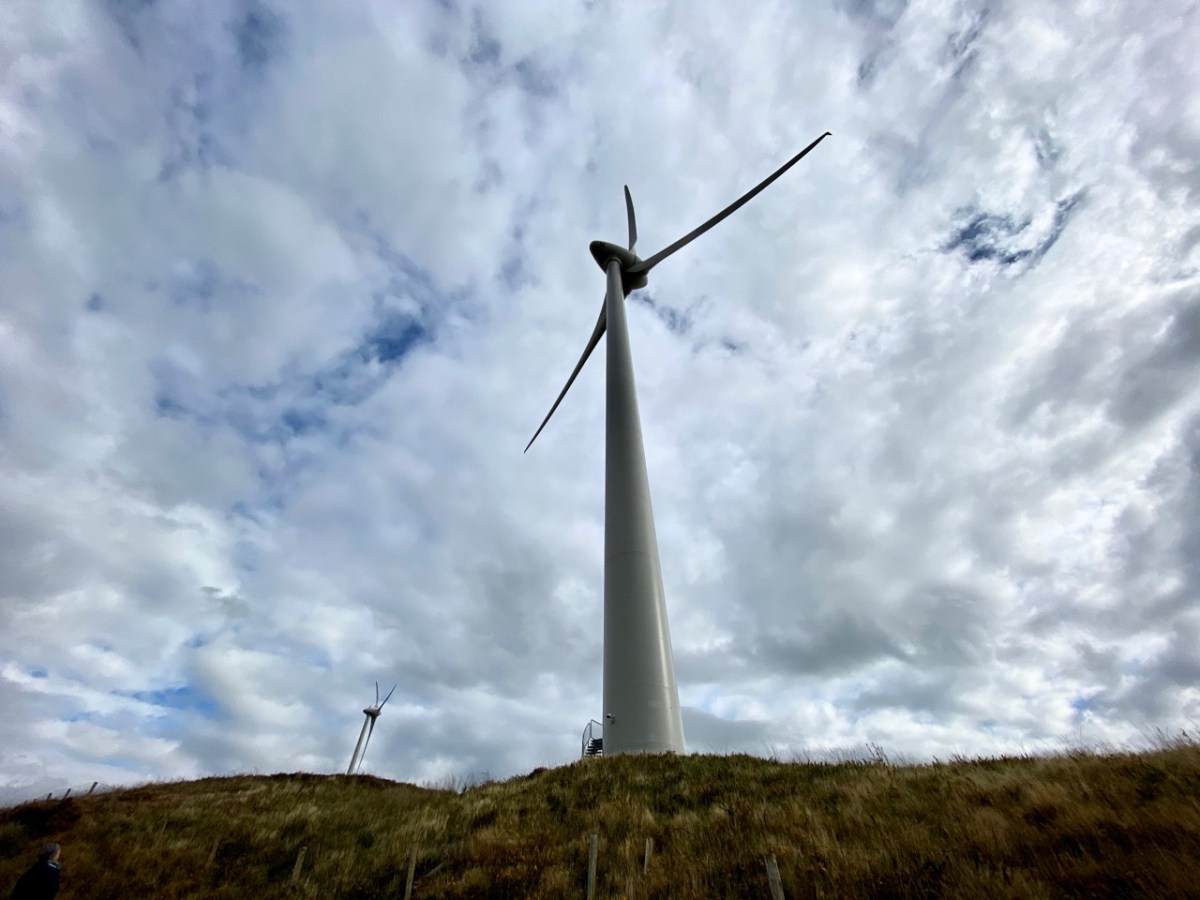
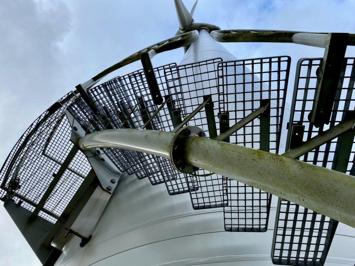
Wind turbines have a huge visual impact on the landscape, so their siting is important. In the case of Ballybane they have been constructed on heathland and in an area that was formerly commercial forestry. I personally prefer the elegance of the actively dynamic structures to a dark, impenetrable and seemingly sterile sitka spruce plantation. The scale is aweing: in the following photographs here’s me at the base of one of the 64m high towers (upper picture) and, below that, you can see me again – the very tiny figure to the left of the main turbine.
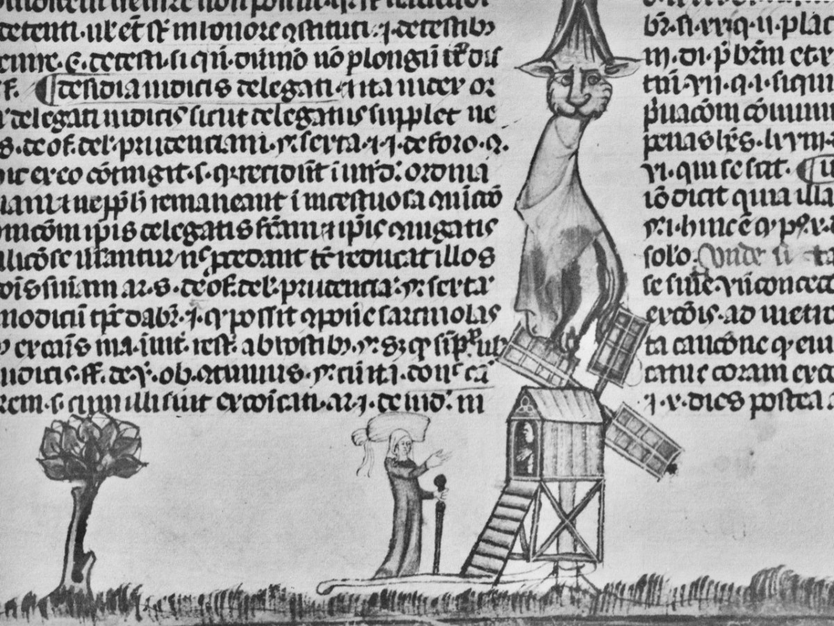
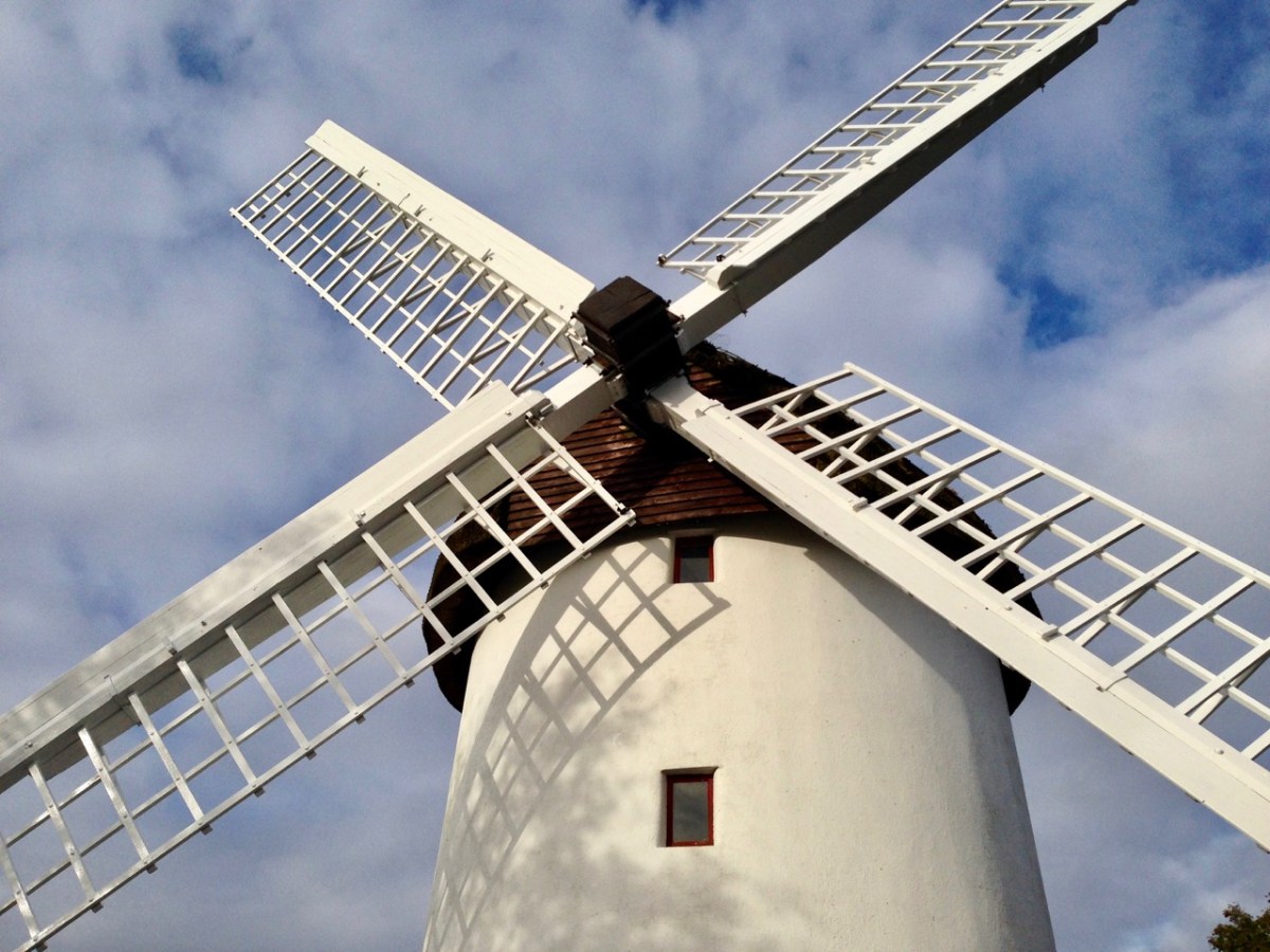
The machinery of industry has always fascinated me. Windmills go back a long way. The first image, below, is from the 14th century Decretals of Gregory manuscript in the British Museum. This is followed by our photograph of Elphin mill, County Roscommon, which dates from 1730 and is said to be the oldest in Ireland. Next, an exploded view of the nineteenth century flour mill at Chillenden, Kent, UK (courtesy of John Reynolds) and then a comparable view of the workings of the Enercon E-70 Wind Energy Converter, which is the unit in use at Ballybane and has a rotor diameter of 71 metres.
The Ballybane Farm will power about 40,000 homes a year on average. That’s modest compared to the newest developments. Currently the world’s largest installation – the offshore Hornsea One Farm, Yorkshire, UK – powers a million homes, while in the Netherlands a huge Haliade-X offshore turbine is being developed with a height of 260 metres and rotor blades of 220 metres in diameter: it’s said that each sweep of the blade will keep a house powered for a day. But that’s enough of the technical stuff. I enjoyed the experience of being close to these giants, and hearing the significant swish of those blades powering us into a safer, carbon reduced future.
Above you can see the trackway leading us up to Constable Lake and the Ballybane Wind Farm. On the horizon is Roaringwater Bay and the distinct profile of Mount Gabriel. There’s an ancientness about this landscape that balances the surreal – somewhat ‘science-fiction’ – character of the turbines. For me, these elements complement each other, and the sheer scale of the contemporary engineering sets us apart from our slight, human selves – so vulnerable in these times.
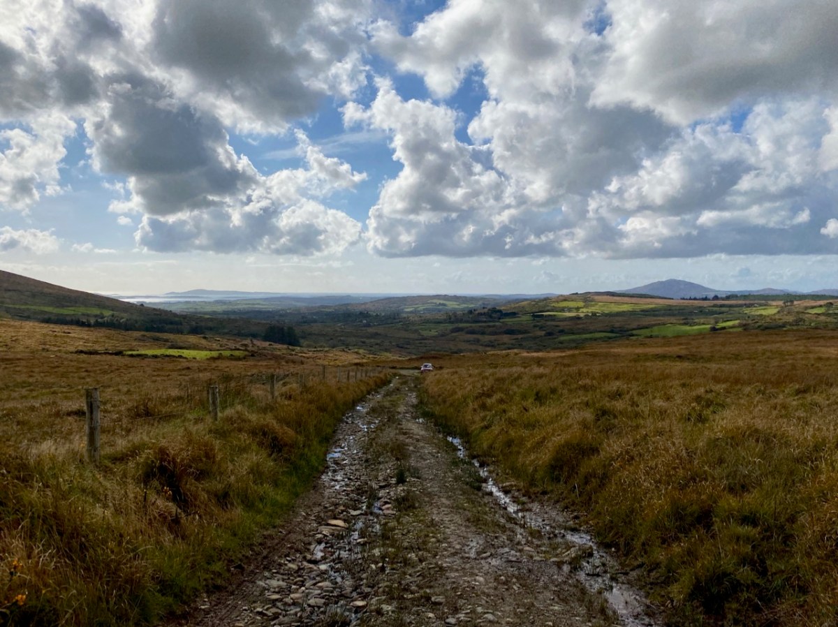
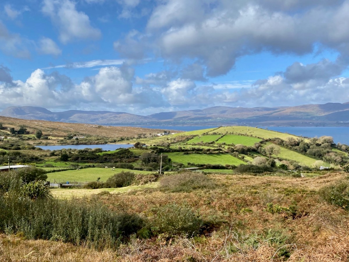
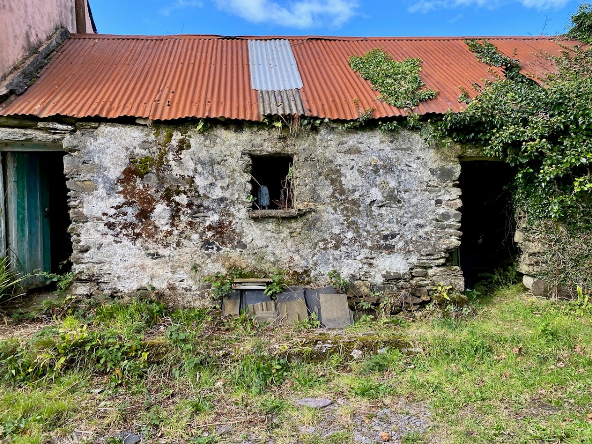
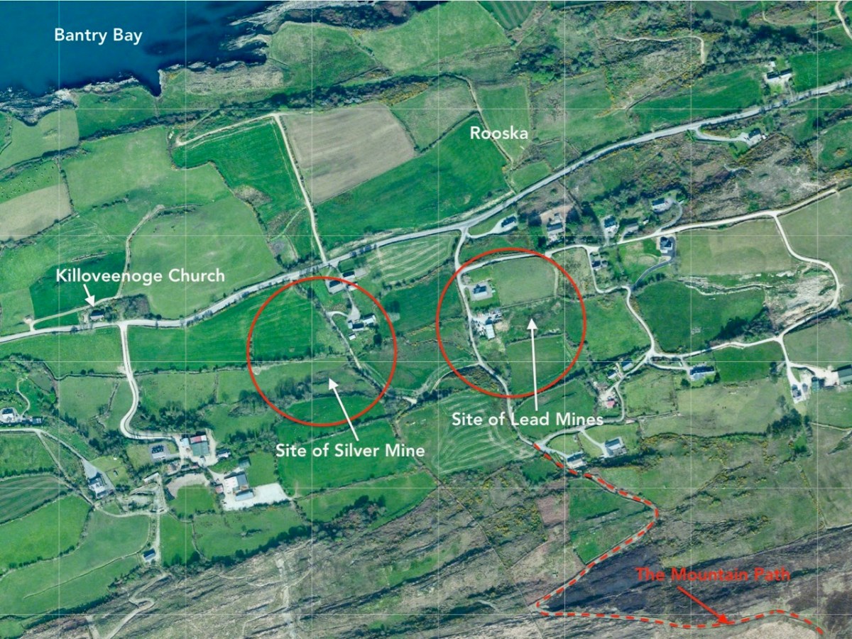
It’s October: autumn light is playing on the skies and seas as we set out to cross the Sheep’s Head peninsula on a path which is new to us. The path traverses the backbone of this peninsula – a ridge which is virtually continuous from east to west – and runs from Rooska, a settlement beside Bantry Bay on the Northside, heading south for Coomkeen and then Durrus. Before we take to the hills, however, we need to prepare ourselves with some sublime scenery en-route, a little excursion into vernacular architecture, and an encounter with local expertise.
From upper – a Sheep’s Head pastoral, the view over Glanlough towards distant Beara; a perfect composition in tin and stone; a niche for offerings? Looking to the ridge – and The Big Gap – in the distance; Joe O’Driscoll with his architectural egg-box. Unfortunately the hens are not laying at the moment!
We are heading to the start of our climb and find a busy settlement, historically once a mining centre and now home to a major award winning seafood producer, bravely weathering the Covid storms. It’s worth a look at their colourful website! You might not expect to see such a venture on the wild and remote Sheep’s Head Northside, but it’s a great boost to a fragile local economy. We wish them well in surviving the Covid19 crisis. Parking up at Rooska, we get first sight of the zig-zagging route that will take us over towards Durrus, passing through The Big Gap at the summit of the hill.
Upper – looking north across Bantry Bay from the path; middle – from the south, the path descends through The Big Gap; lower – the path can be seen on the right cutting through the hills: the highest point is 200m above sea level
I tried in vain to find a name for the way we followed. I would like to have called this post The Mass Path, which is given to it on a modern guide, and it does seem probable to us that one purpose of the trackway would have been to take Northside dwellers over to the old Catholic church at Chapel Rock in Durrus, a distance of 7 kilometres (or four and a half miles in older times). There and back would have been a taxing walk for a Sunday morning on an empty stomach (you have to fast from midnight before taking communion)! However, we were told locally that our intended way will lead us through The Big Gap, hence my title.
This view over the Northside area of Rooska, above, shows several features and the beginning of the path over the mountain heading south. Notable is Killoveenoge Church, known as a ‘Chapel of Ease’ and said to have been built in the 1860s specifically for the English and Cornish miners who were working in the nearby silver and lead mines at the time. There are scant remains of these mines now, and the Church of Ireland building was closed in 1988 and converted to a studio.
Looking down on Killoveenoge Church from The Big Gap path, with Bantry Bay beyond
The townland name Killoveenoge translates as Church of the Young Women and the only explanation of this I could find suggests that the site was anciently a priory, sacked by the Vikings in 890AD. It is also said that some ruins of this are visible, but we failed to find them – nor any factual historic records. The Schedule of Monuments notes a circular burial ground in the west of the townland with early grave markers, but nothing more. Clearly folk memory transcends recorded history, and that is one of the attractions of Ireland – to us, at least.
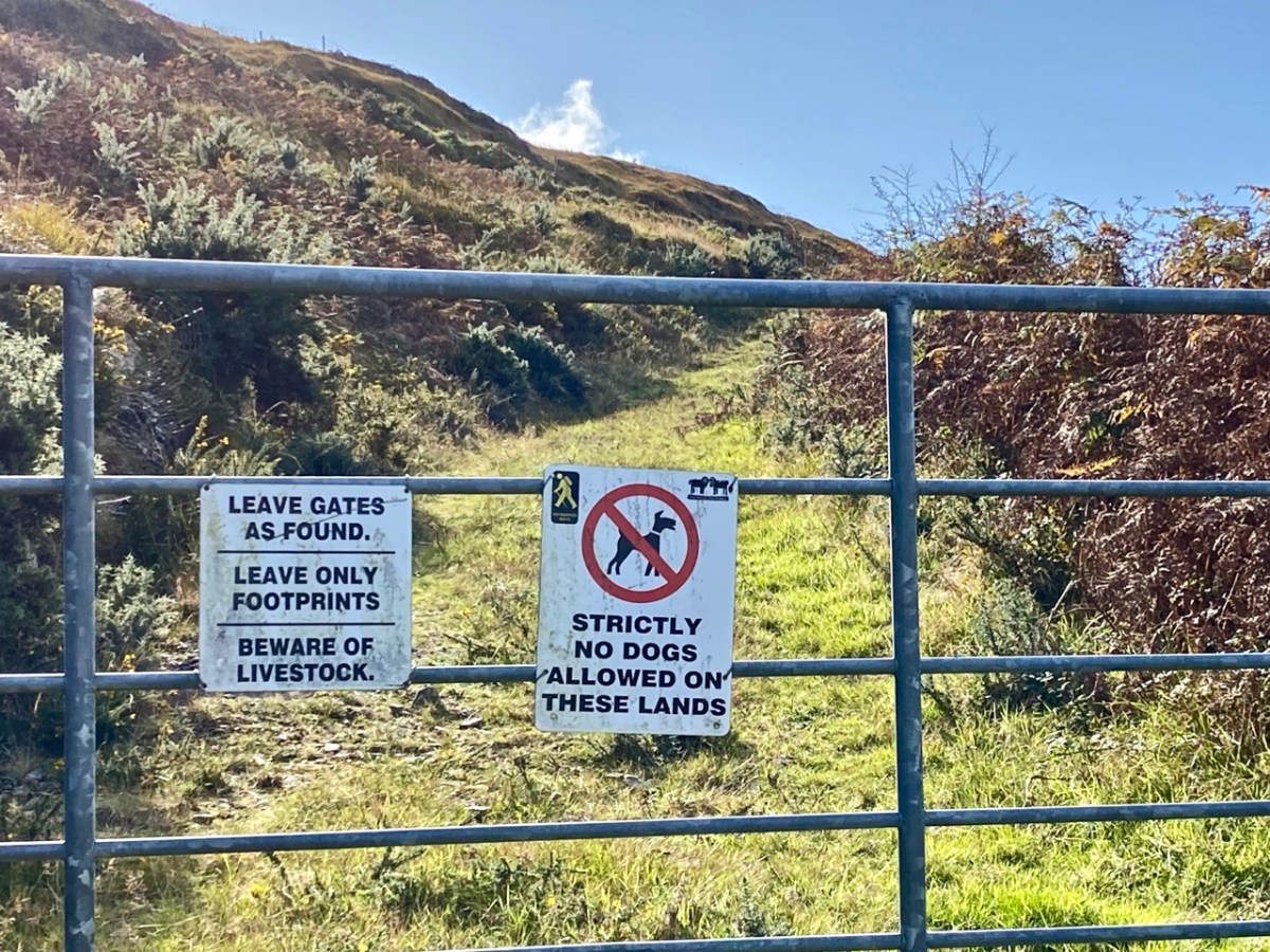
Upper – The Sheep’s Head Way trails have a strict code, which benefits all users; middle – the ruins of a cottage almost lost in the furze. The mining records mention a ‘miner’s cottage’ still being visible: could this be it? Lower – gaining height as the path gets steeper: that’s Whiddy Island in the distance
The wider aerial view shows the full length of the old trackway as it crosses the mountain through The Big Gap. Just past the summit when heading south is another landmark, also holding a folk memory. Lough Na Fuilla translates as ‘Lake of the Blood’:
A reed-filled lake suddenly appears; so many different greens, so far from anywhere and the gentle murmuring of the reeds all combine to make a rather unsettling atmosphere . . . Maybe it’s knowing the name of the lough, Loch Na Fuilla, lough of the blood, that plays tricks on the mind. There is a story attached, of course. One extremely hot summer the cattle came down from the mountain in search of water. The lough was empty. Maddened with disappointment and thirst the cattle went berserk and attacked each other and many were killed.
Walking the Sheep’s Head Way – Amanda and peter Clarke – Wildways Press 2015
Lough Na Fuilla, and a nearby tarn on the east side of the trackway. The autumn colours are sublime
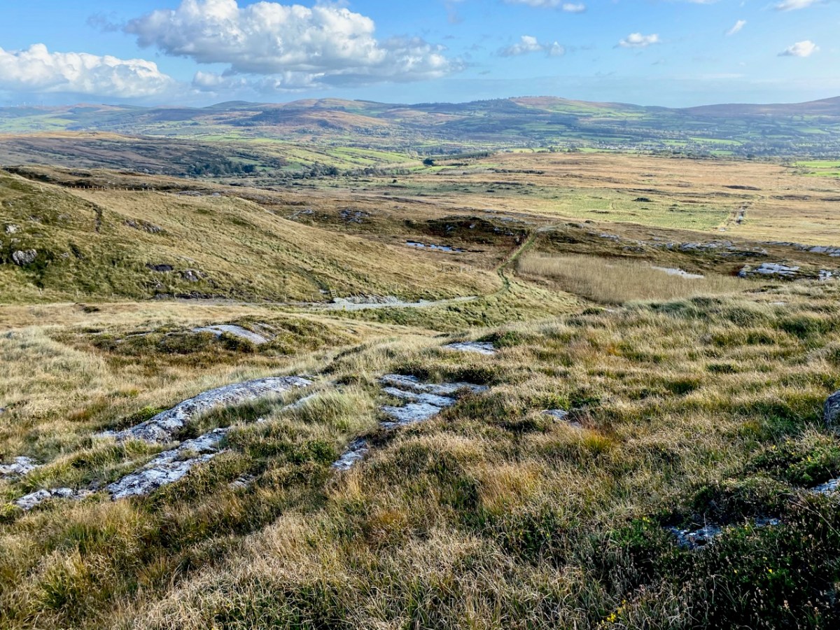
Neither the Lake of the Blood nor the nearby tarn are shown on the early OS maps. The few remaining mining records, however, mention that there was some prospecting activity up on the ridge: could this have relevance? And is this another reason for the existence of this path? We are impressed with the views from The Big Gap both north and south. We temporarily divert on to a stony sheep path to get even higher, and to find the best panoramas. From the ridge we also record the contrasting light and shadow effects from a constantly changing sky.
We pause to wonder whether a large rounded outcrop is the Eagle’s Rest which is mentioned by local historian Willie Dwyer, of Rooska:
The gap going through the mountain there, by Loch na Fuilla, the locals always called it, that’s the old people who are dead and gone now, used to call it “Barna Mhór” which means “The Big Gap”, and on the right-hand side (the north-west corner) before you come to the extreme top of the track, there’s a round bald rock which was known as “the Eagle’s Rest”. I don’t know how long the eagles have been gone out of this part of the country, but it must have been a long time ago. This is a tradition now, it has been passed down as tradition, how true or false it is, I can’t prove to you.
Willie Dwyer, Quoted by TOM WHITTY in ‘A guide to the Sheep’s Head way’ 2003
From The Big Gap it’s downhill all the way! As we walk south it’s the Mizen which is always on the horizon, across the waters of Dunmanus Bay.
As we approach the southern end of the trackway crossing the mountain, we look back up towards Barna Mhór – The Big Gap. It has been a most rewarding adventure for us, and one which we intend to repeat at other times of the year so that we can capture the effects of the changing seasons.
Welcome to the UCD Library Cultural Heritage Collections blog. Discover and explore the historical treasures housed within our Archives, Special Collections, National Folklore Collection and Digital Library