Black Castle, or Leamcon

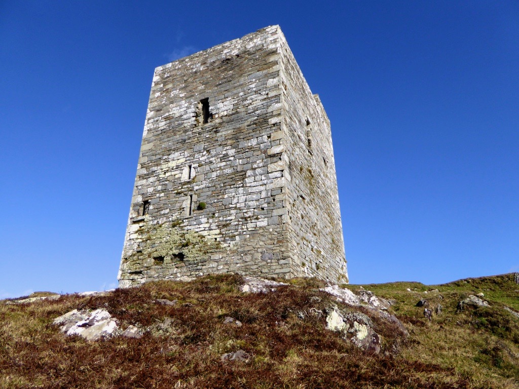
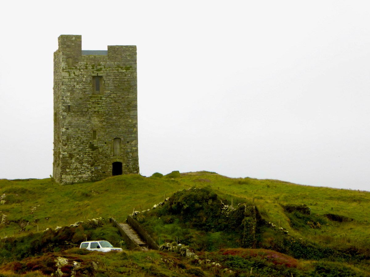
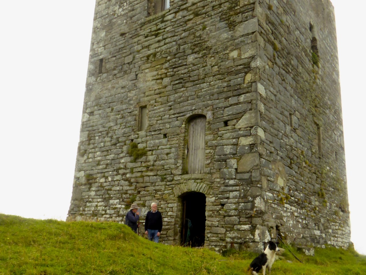
This is the fourth castle in my series The Castles of Ivaha, and the final one which is intact enough to be able to describe in detail (although I may have more to say about those which are more vestigial). Not just intact, though – Black Castle has been superbly stabilised and saved for future generations by its owner, Niall Hyde. 

Niall, by the way, thinks the the term Black Castle is more historically accurate. He points out that there is, in fact, in the townland of Leamcon, about 2km to the northeast, another ‘turret’ marked on the old OS maps, which is the remains of a castle built by the notorious Sir William Hull. Black Castle is in the townland of Castlepoint, and its name neatly distinguishes it from White Castle, AKA Ardintenant. Both were built by the O’Mahonys.

James Healy’s drawing of Black Castle from his wonderful book The Castles of County Cork, Mercier Press, 1988

As I said in my post on Ardintenant Conor Cabaicc succeeded his father in 1427 and remained Taoiseach for 46 years, embarking on an ambitious program of construction to provide castles for his sons and brothers. This included Black Castle, which he built for his second son, Finín Caol (pronounced Fineen Kale), or Finín the Slender. This means that Black Castle was built in the period before Conor Cabaicc (Conor the Talkative) died, in 1473. This accords well with its architectural details, which place it among the fifteenth century ‘raised entry’ castles, similar to Ardintenant, Dunmanus and Dunlough

The best source material for all the castles of Ivaha is the thesis The Tower Houses of West Cork by Mark Samuel. Here’s what Samuel says about the location of Black Castle, which he refers to throughout as Leamcon. Leamcon, by the way, means Hound’s Leap, which Samuel suggests may refer to a legend about the gully across which you must pass to get to the castle.

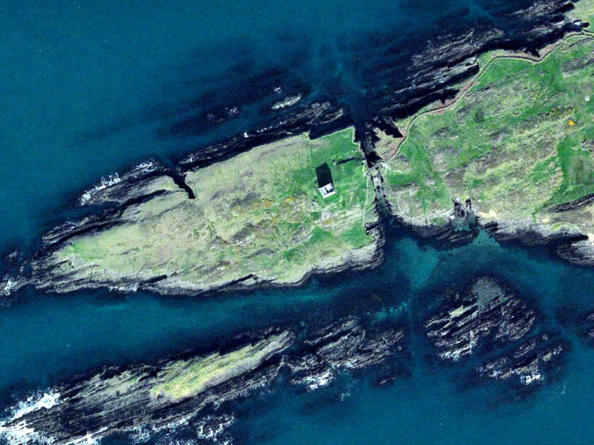
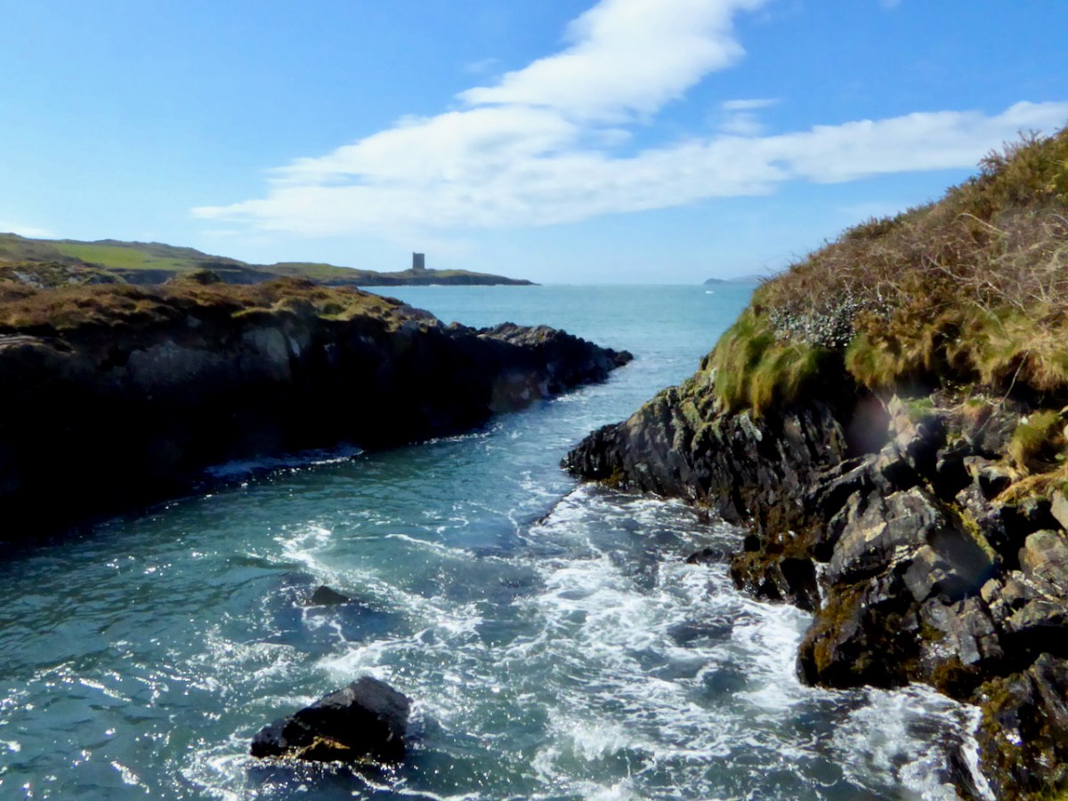
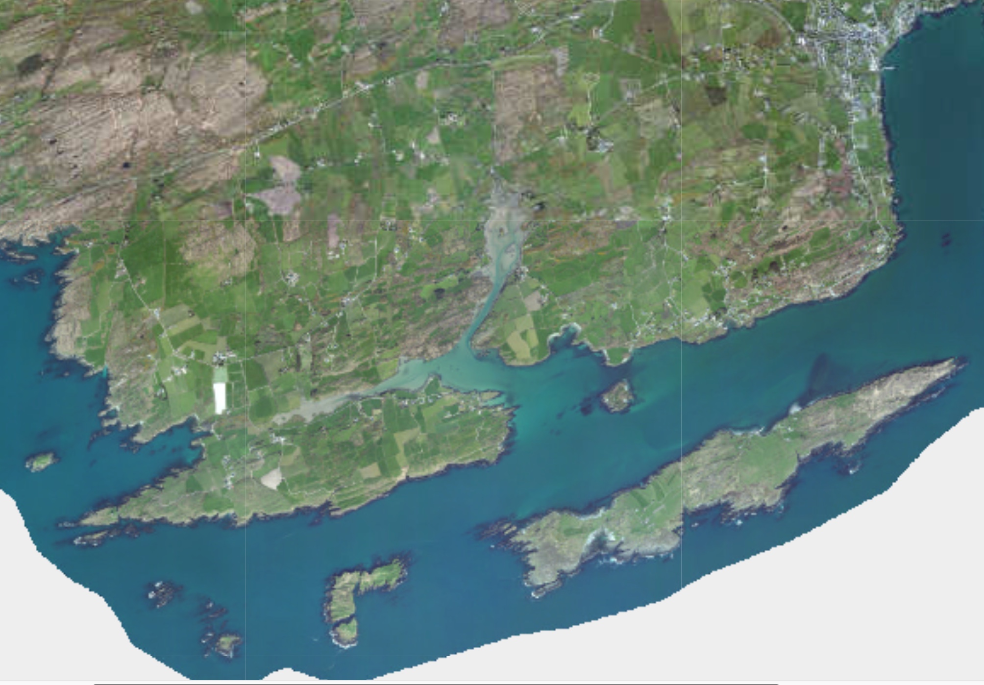
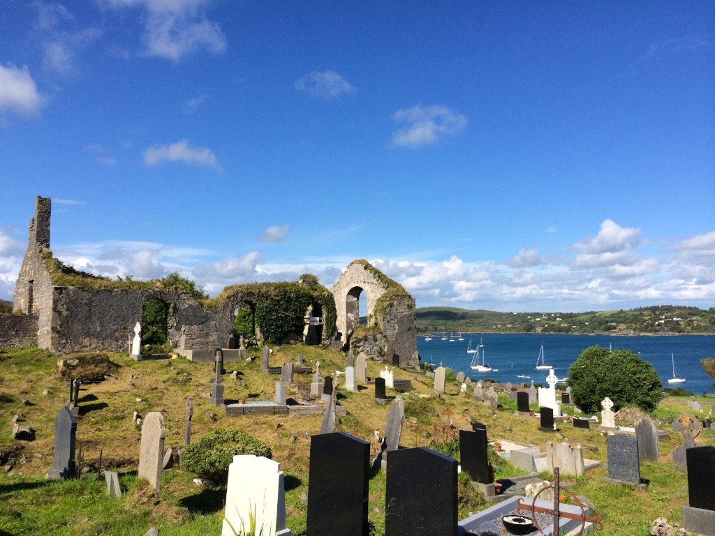
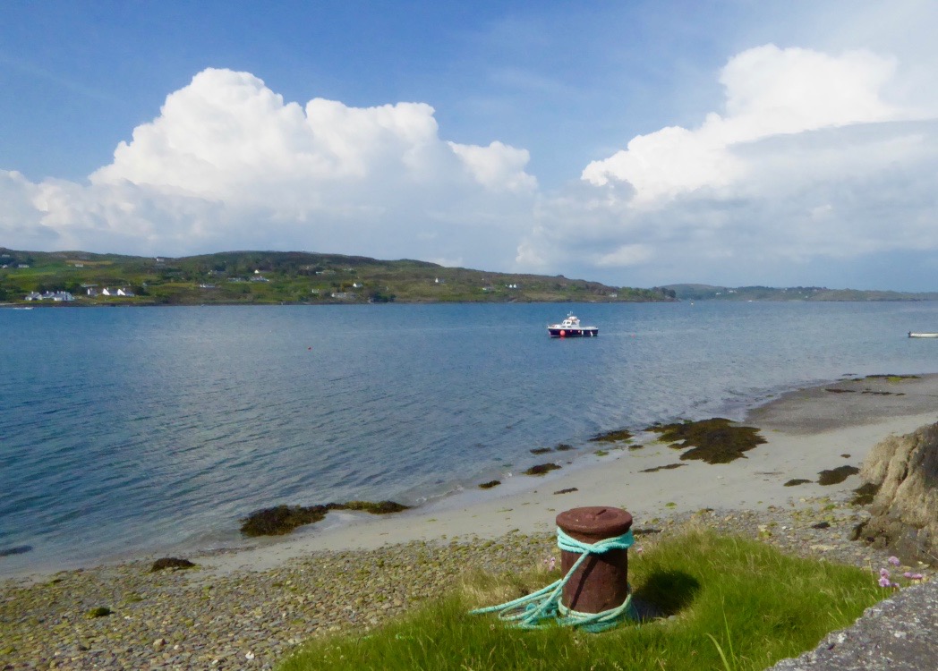
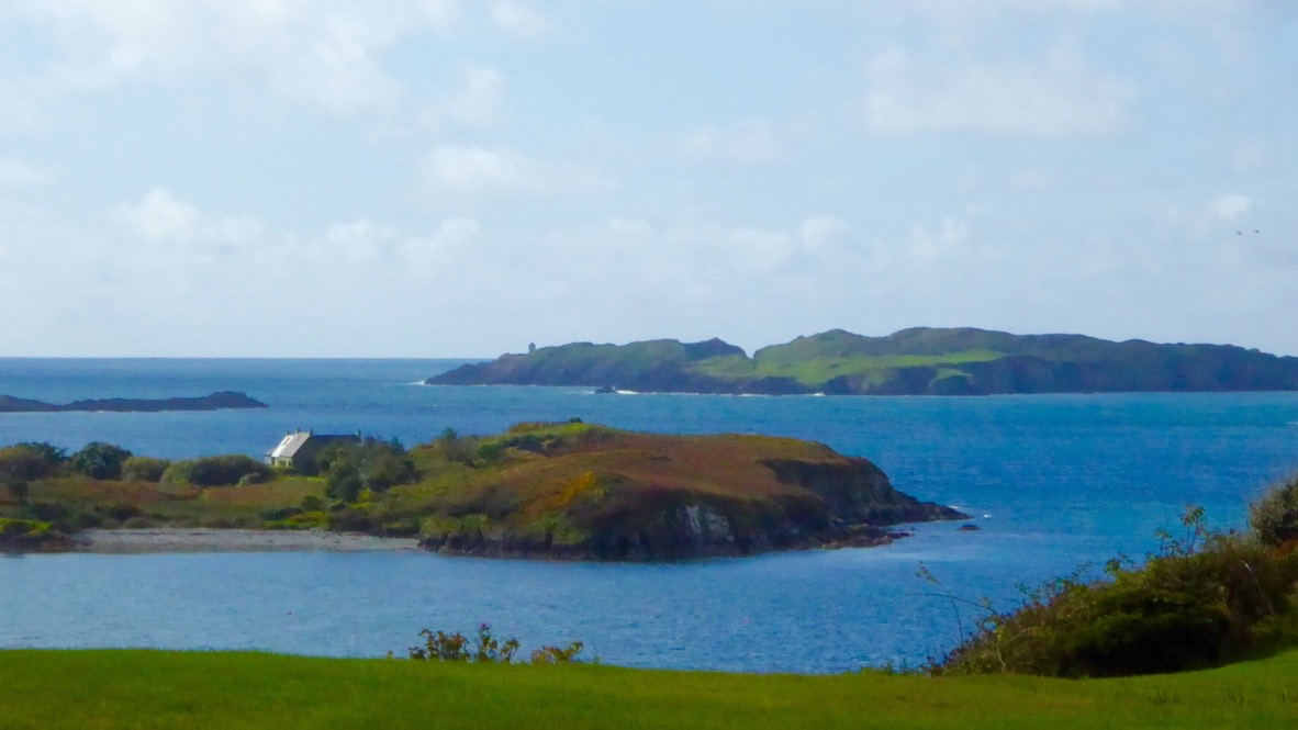
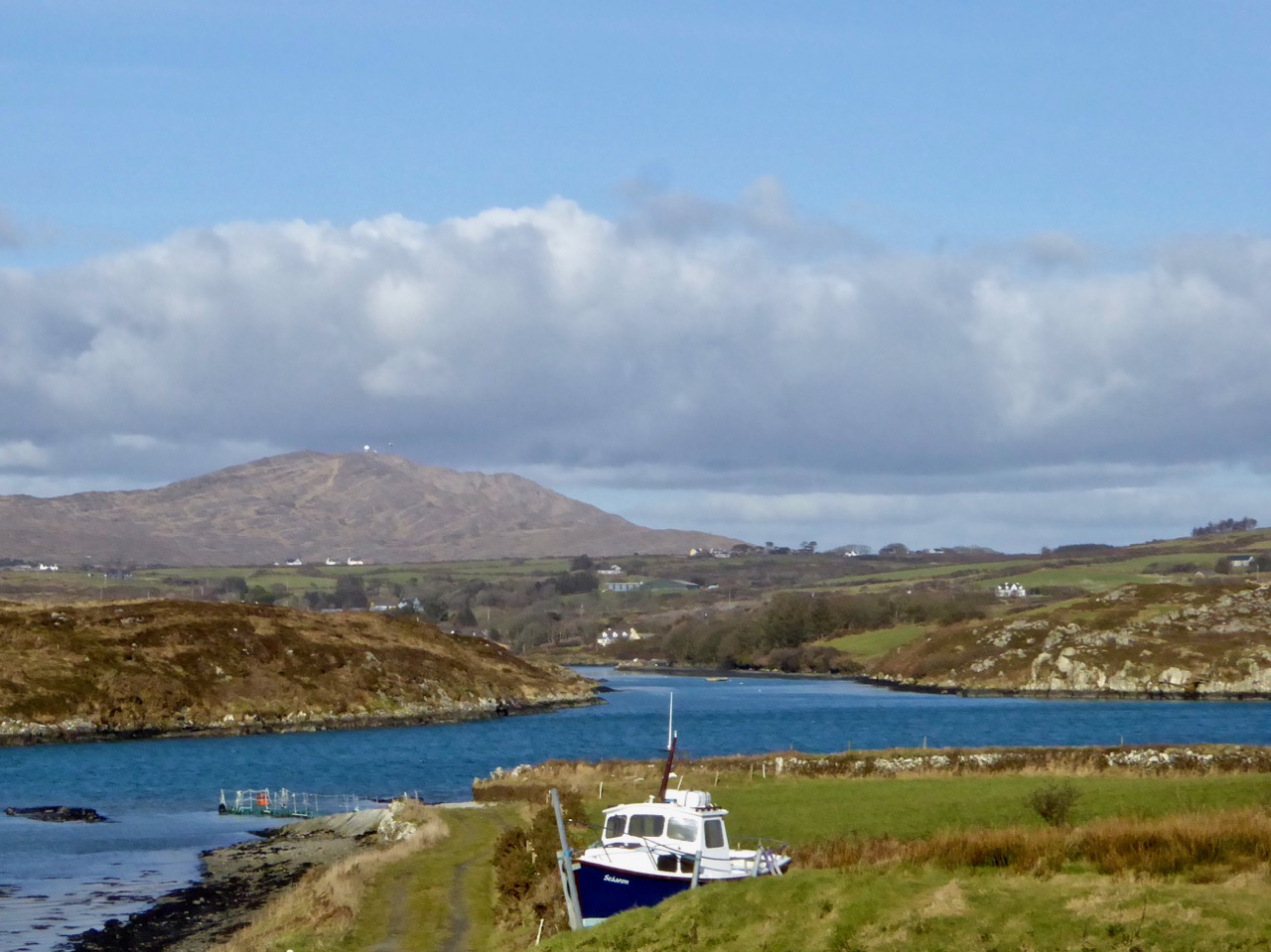
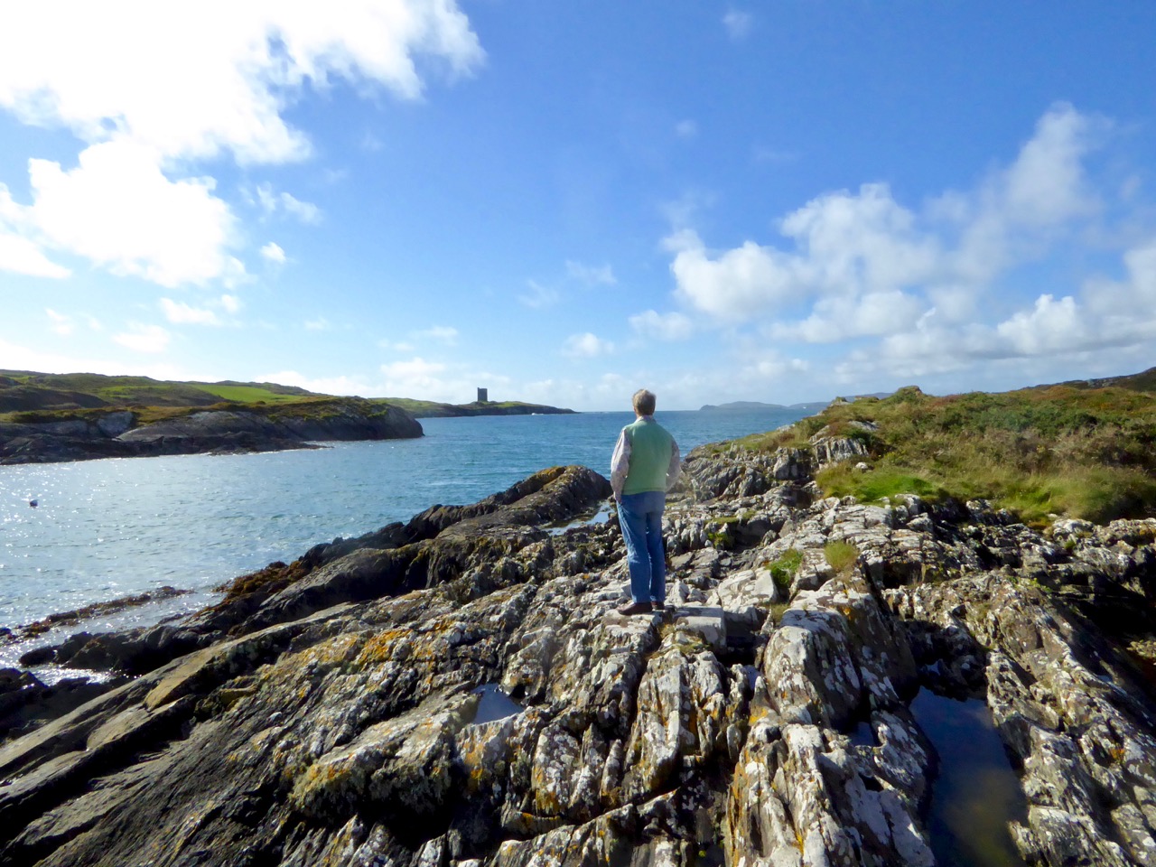
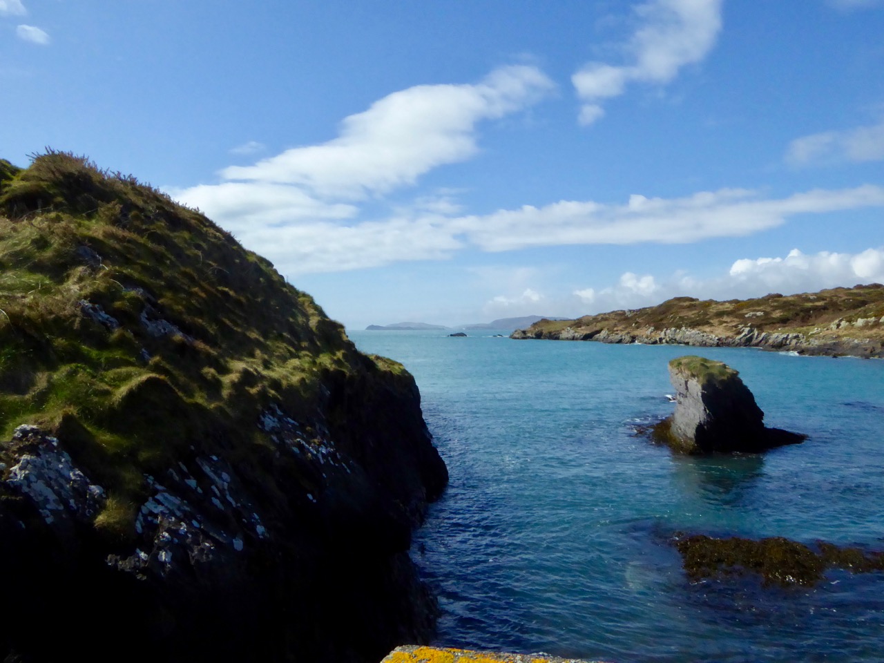
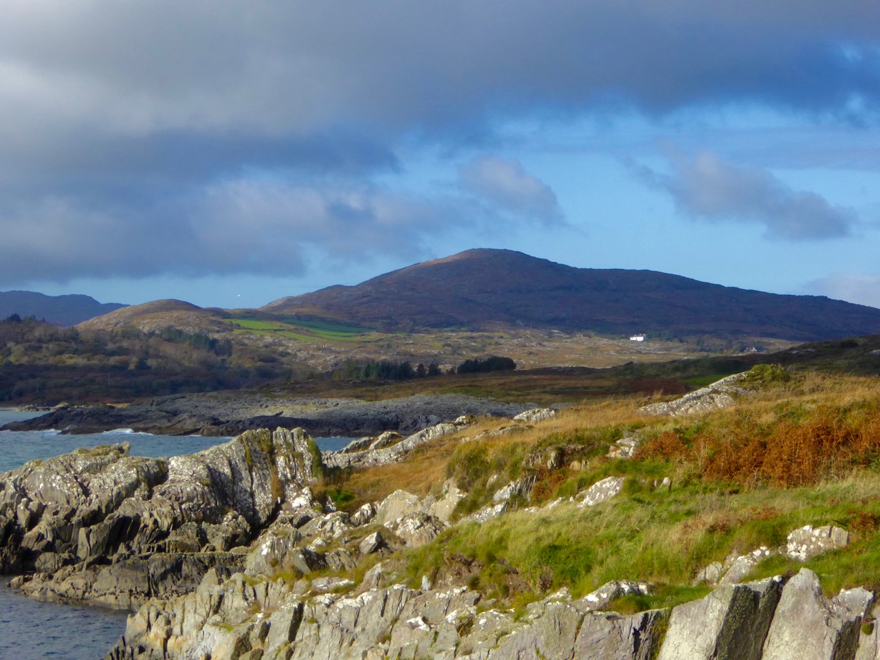
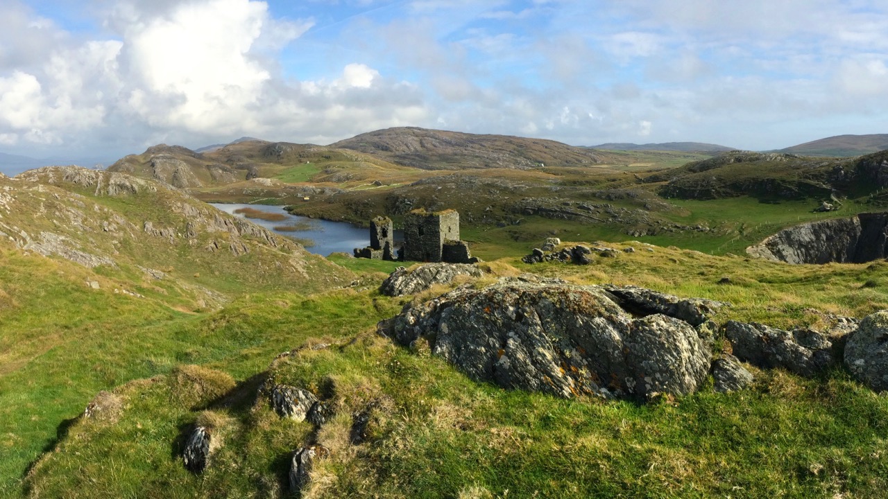
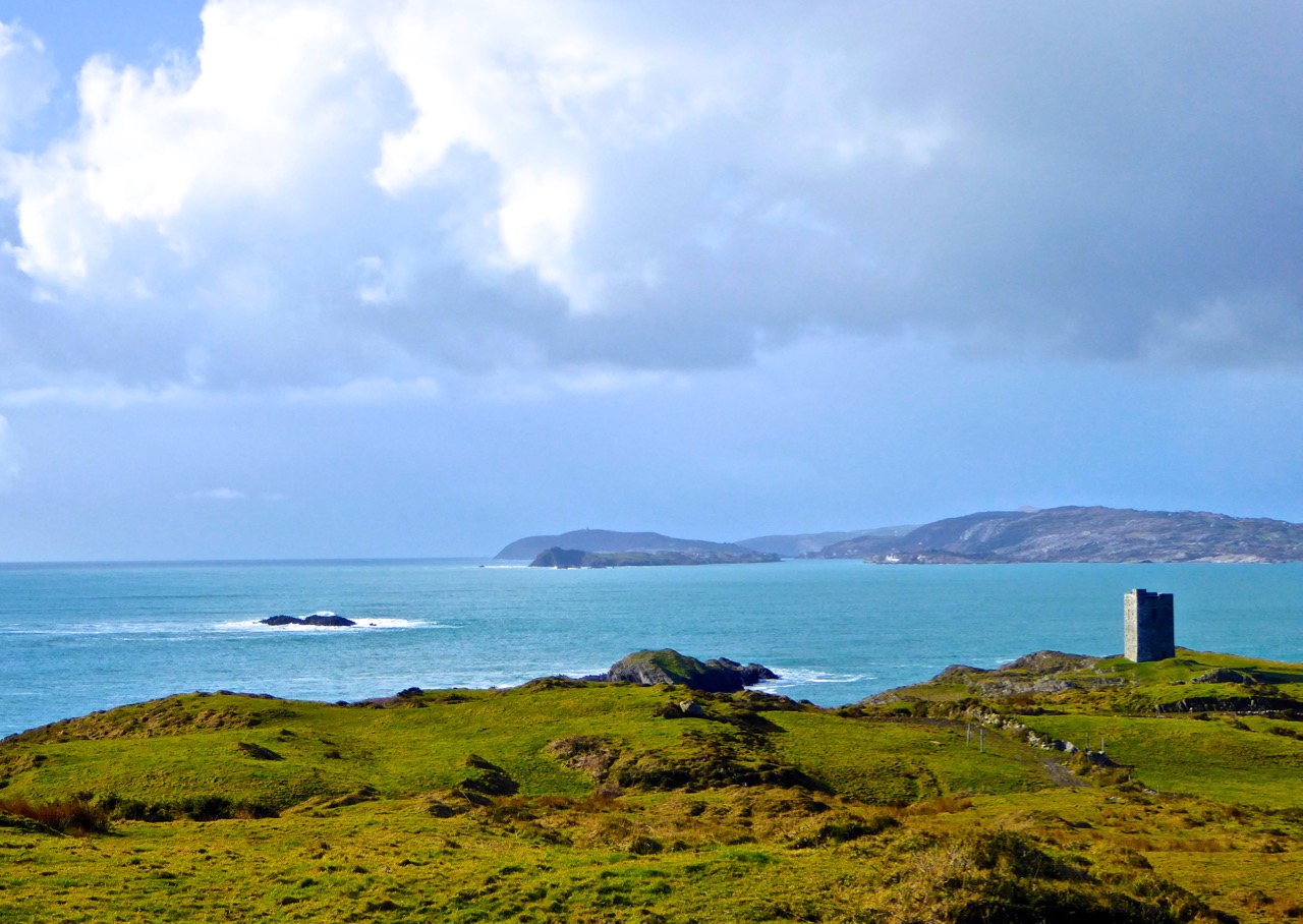
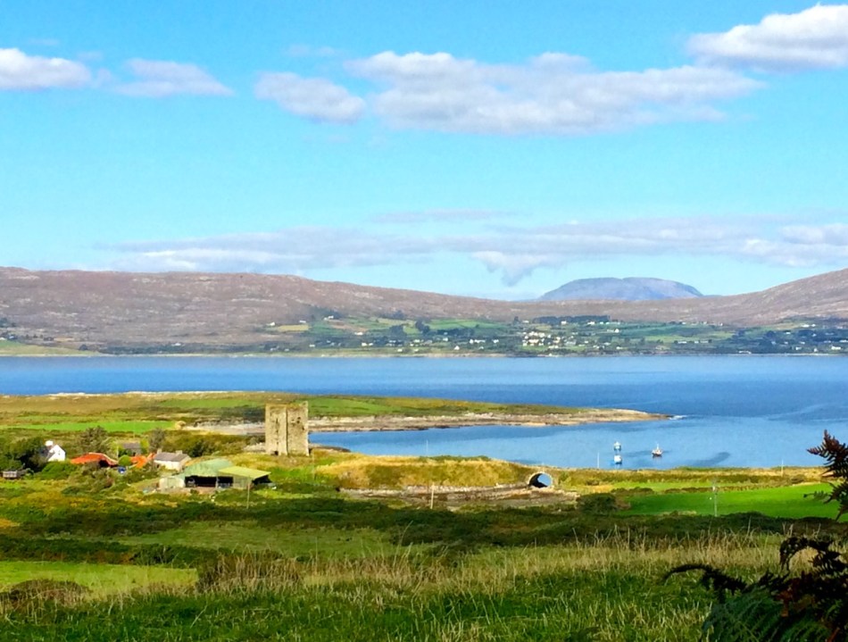
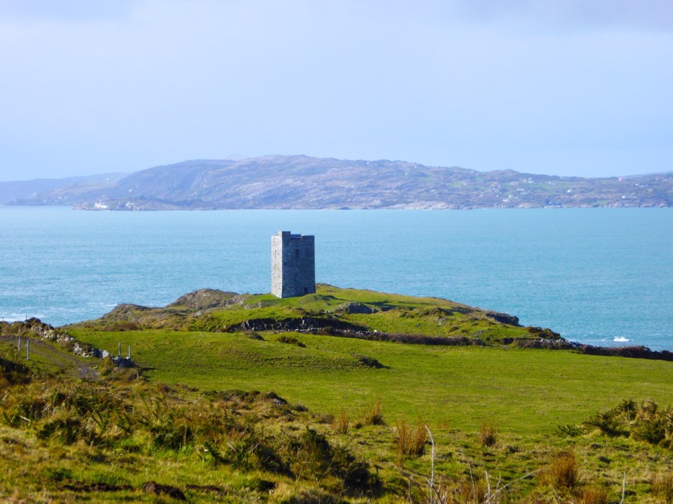
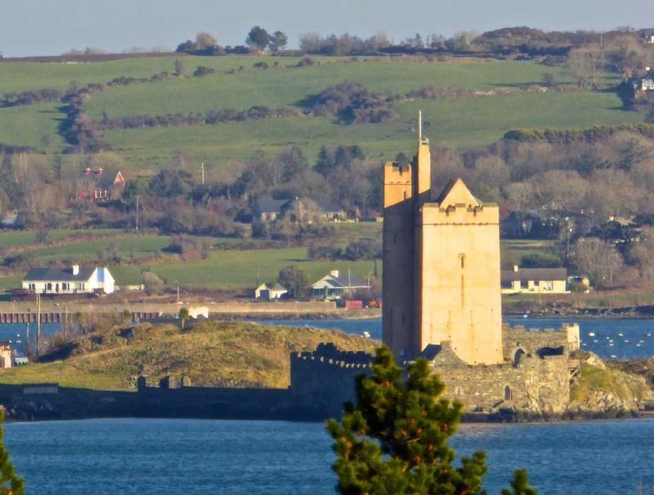
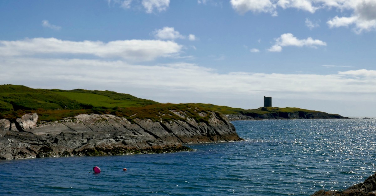
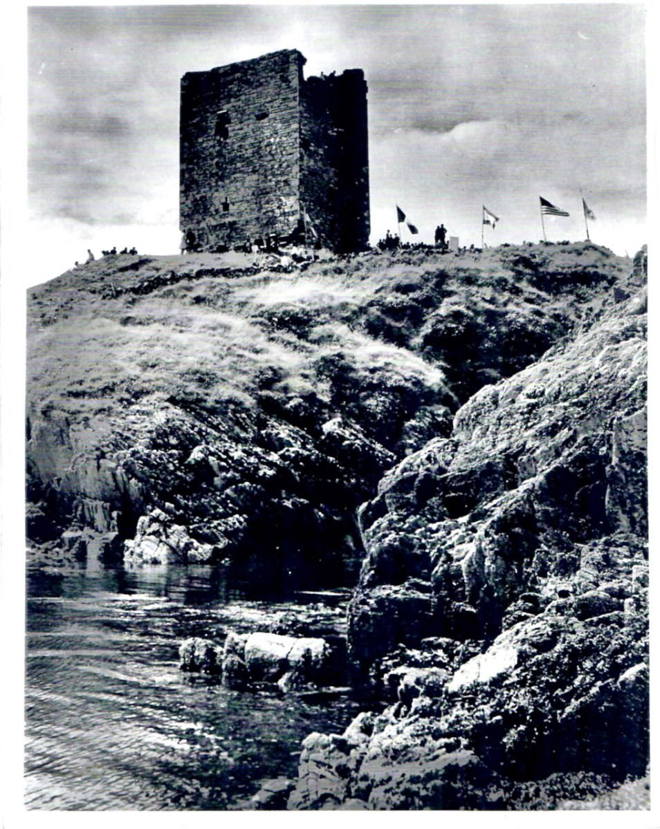
The western part of the Ivagha peninsula, the territory of O’Mahony Fionn, is now sparsely populated. Away from the formidable Mizen Head, the ice-sculpted land meets the sea with low, rocky cliffs. In this part of the Survey region, the strike of the rock is almost south-west/northeast, the layers being tipped close to the vertical, the shore tends to be sculpted into long peninsulas and islands running along the strike. Exposed to the Atlantic, it is a wild treeless shore. The fields once densely fanned prior to the famine, are now mostly given over to pasture. The tower house stands far from any road at the west end of a long narrow peninsula. Erosion has nearly severed the tip of the peninsula; only a precarious natural bridge, now reinforced with concrete, joins it to the mainland. The island is large, the ruins cover only a small fraction of its area. The tower house stands towards the island’s east end at its highest point. The promontory is for the most part gentle in relief, being covered by grass-grown ‘drift’ deposits.

THE TOWER HOUSES OF WEST CORK
MARK WYCLIFFE SAMUEL, 1998

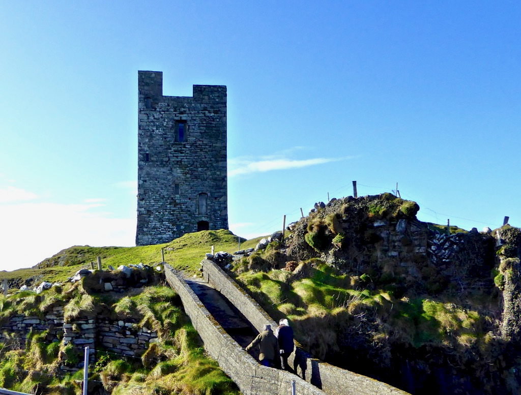
When Niall bought the property the bridge consisted of a few planks. It must have been a hairy business getting across to it until he built the concrete walkway you see today. Niall and his family spent their summers at the castle – can you imagine, as a child, what it must have been like to have your own castle to play and live in? Magical! Although I do think about what it must have been like for Dorothy, who spent the weeks there with the children while Niall worked in Dublin. How did she manage to feed them and keep them safe? A heroine, indeed.

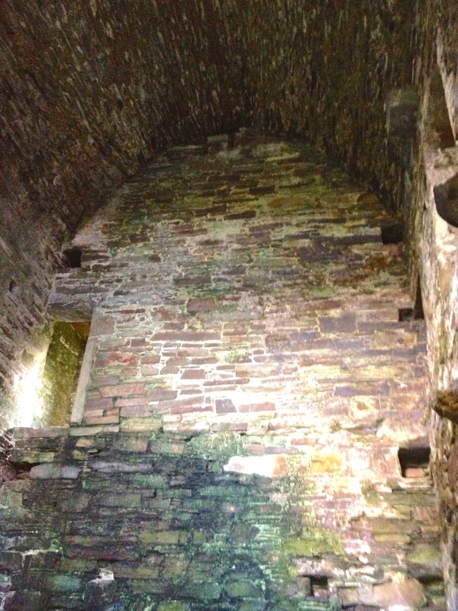
Like the others I have described in detail, Leamcon is a raised entry castle. To recap – the ground floor entry gave access to the ground floor, and possibly by means of a ladder to the second floor and mezzanine. The raised entry gave access to the second floor, and then, by means of a strait mural staircase, the the floors above the vault. Take a look at the cut-away diagram in Illustrating the Tower House: A Guest Blog to see what I am talking about here. Thus, the upper floors could only be accessed by one staircase, a defence feature, and being above the vault provided security from fire in the lower floors. Given that there were no fireplaces, and that braziers were lit in the middle of the floor, with smoke escaping however it could, this was probably a good idea.

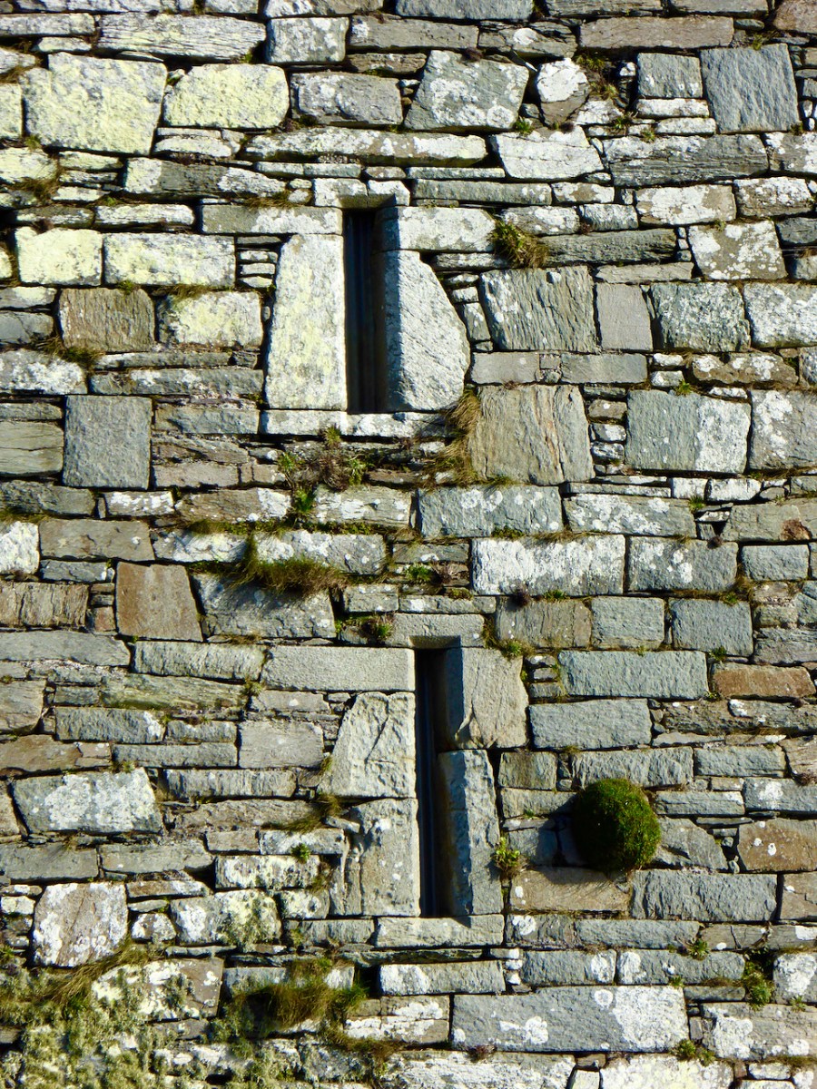
Another defensive feature was the small opes, or windows, through which no attacker could climb and little light could penetrate

As regards defence, the castle was attacked by Carew’s forces after the Siege of Dunboy in 1602. According to Samuel:

Sir George Carew reported, on 13th July 1602, that his lieutenant, Captain Roger Harvy, had taken several castles strongly seated on rocks and necks of land. All were so ‘neere unto the sea where ships may safely ride, and fit places for an enemy to hold as, namely Leamcon, Donnegall’ and others. The decision was taken to burn these tower houses. Conor, the head of the sept, received quarter with his men and migrated to Spain immediately afterwards. He was subsequently pardoned but seems never to have returned.

THE TOWER HOUSES OF WEST CORK
MARK WYCLIFFE SAMUEL, 1998

Black Castle wasn’t burned and it subsequently was reclaimed for a time by the O’Mahonys, although the clan forfeited all or most of their lands after the rebellions of the 1640s, and the castle was abandoned from at least the 1690s. Such was the state of it when the O’Mahony Reunion took place here in 65 or 66.

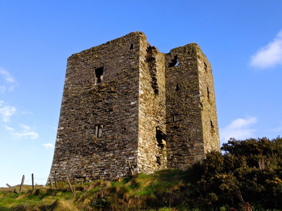
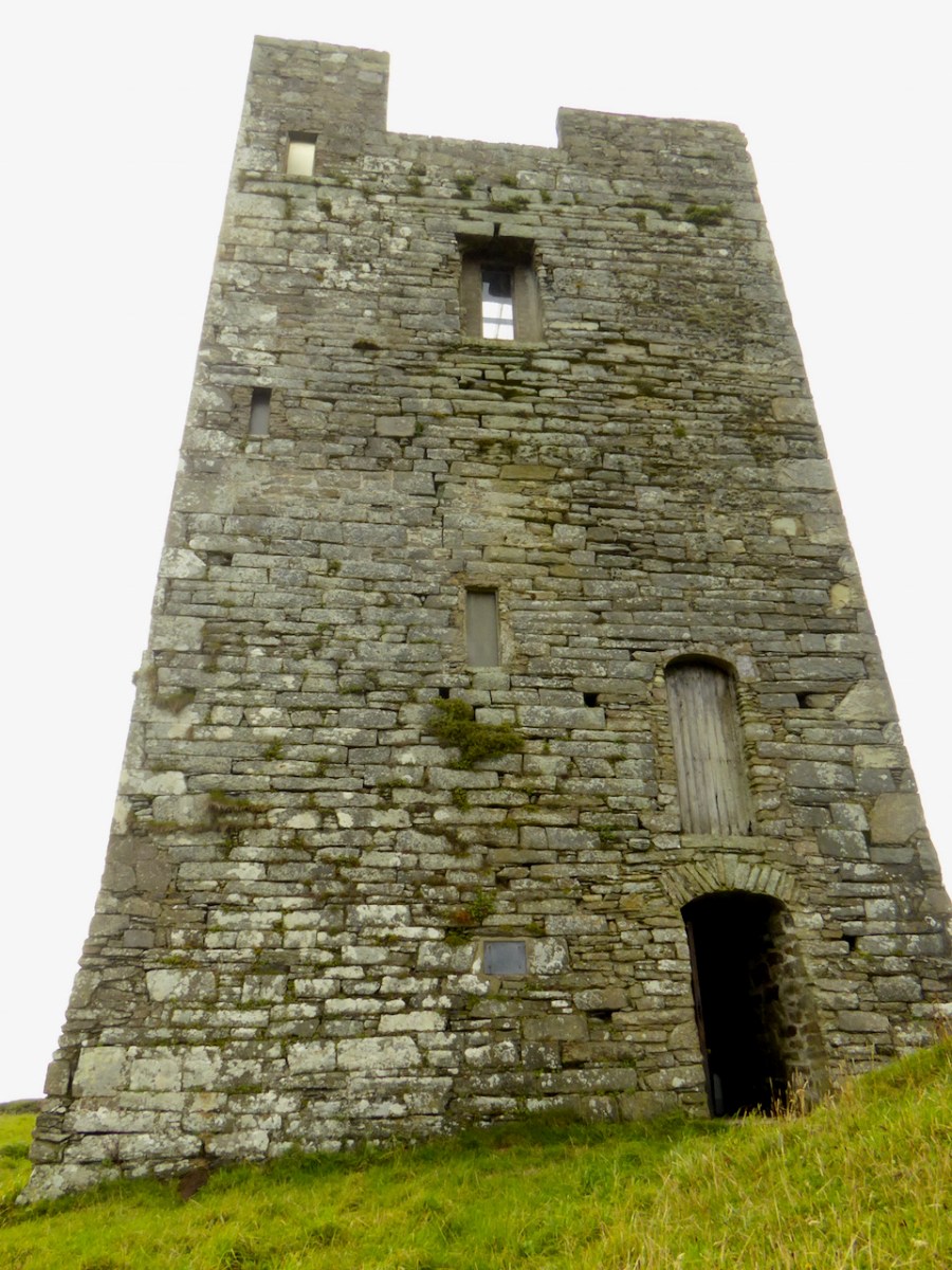
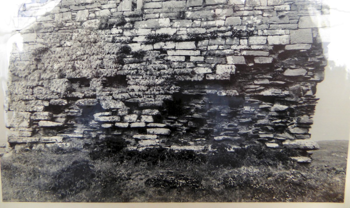
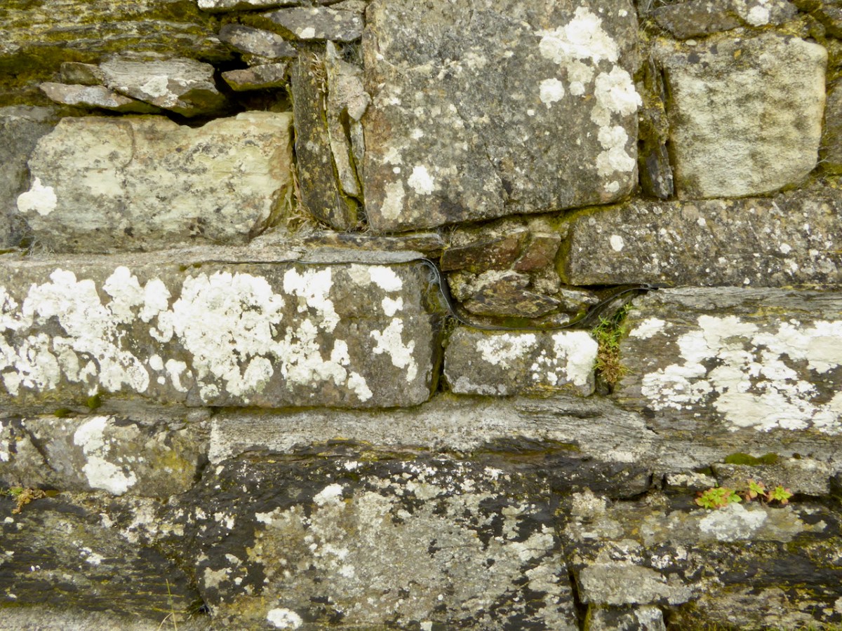
All those years of neglect had resulted in a castle in a perilous state of dereliction and Niall and his builders set about stabilising it before they could make it habitable. The base batter – the broad foundation that give the walls a strong base – had first to be repaired. This called for great skill and the results are impressive. Niall has left a band of membrane to indicate where the old and new stone work meets.

The castle was built to align with the strike of the rock, a feature of most of the Ivaha tower houses. The strike is the compass direction in which the rock bed is running and for West Cork that is mainly in a northeast to south west direction. The builders chose a prominent and solid rocky platform, still easily discernible, and probably prepared it by digging away any soil and loose rock and may have laid down a layer of mortar to help bind the lowest slabs to the rock surface. 

At Black Castle, the quality of the masonry varies, leading me to think that not all stone masons were as skilled, or perhaps as careful, as others. See the variation in the image below. The quoins (corner stones) were made of fine-grained sandstone that can be freely dressed in any direction (called Freestone), while the stones used to dress the outer layer were carefully chosen (or deliberately shaped) to be smooth and even, lending a pleasingly sheer surface to the castle exterior, sometimes called  an “ashlar finish.”

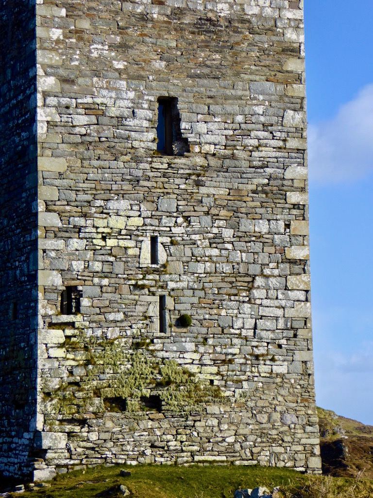
The raised entry, in the case of Black Castle, is directly about the ground-level entry, similar to Ardintenant, but unlike Dunmanus where the entries are staggered. The entrance to the upper door would have been by means of a wooden staircase, possible from the small rocky knoll across from the entrance.

In his conversion of the castle to provide habitable space, Niall concentrated on the upper floors. There is a living room, kitchen dining area and bedrooms, along with a toilet and shower which are situated in the original garderobe space. 

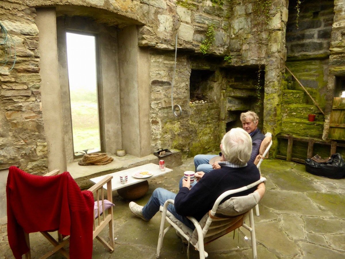
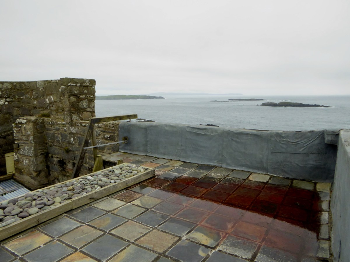
By roofing and waterproofing the building, Niall has kept further deterioration at bay. It is a joyous thing to sit and look over the countryside with a cup of tea on hand, or to climb up to the wall walk and gaze over the wild and rugged peninsula, imagining Carew’s forces advancing across the sea.

Niall Hyde has managed, on a limited budget, to salvage Black Castle and indeed turn it into a space that his family enjoyed. We should all be grateful to him, and to others who have taken on such tasks with vision and courage. Without the Niall Hydes of this world, we would all be the poorer.

Mizen Magic 6: Schull to Castlepoint

The Mizen is the Peninsula we live on, and of course we think it’s the most beautiful part of West Cork, and of Ireland. In previous Mizen Magic posts I’ve been exploring different aspects and areas, such as the Northside, or Brow Head, or our excellent beaches. This time I’m concentrating on the stretch from Schull to Castlepoint. The map below shows the area, with the village of Schull, our starting point, on the top right. The photograph above was taken from the top of Sailor’s Hill.

A winter view of Long Island Sound – Coney Island, Long Island,  the Calves, Cape Clear and Sherkin, with the entrance to Croagh Bay in the foreground

It’s only a few kilometres, and it would take you about ten minutes to drive straight to Castlepoint from Schull. But where’s the fun in that? No- let’s start by driving (or walking if you’d rather) out to St Mary’s Church on the Colla Road. It’s largely an eighteenth century church, although there are hints of a medieval structure here and there, and it stands in what must be one of the most scenic graveyards in West Cork.

Intriguing depictions of boats are inscribed into the render inside the church. How old are they? Who did them and for what purpose?

From there, I suggest you drive to the lookout on Sailor Hill – the trail arrows for the new extension of the Fastnet Trails will show you the way. We discovered Sailor’s Hill ourselves when I was researching belvederes – the redoubtable Connie Griffin has built his own modern version of a belvedere and there is no better place to get a view of Long Island Sound and the south side of the Mizen. Here’s the viewing house Connie built  – perfect for contemplation.

Back down to the Colla Road, continue to the scenic little Colla Pier, where you can take the ferry to Long Island. Robert and I do this every year as part of the Fastnet Film Festival. The ferry runs every day but you can also book special trips – it is, as they say here, a great day out. Pack a picnic and your camera – there’s lots of birdlife, including these oystercatchers on the rocks at Colla Pier.

The ferry leaves Long Island for the return trip to Colla Pier

From the Pier the road winds across country, overlooking the sea here and there, and always with Mount Gabriel looming in the background. From here you can see tiny Coney Island, privately owned, and with one house which is rented out to holiday makers.

Beyond Coney Island are the Goat Islands – Goat Island and Goat Island Little – probably once one island, but now split into two, with a narrow passage between. There are feral goats on these islands, but not much else. They appear to be completely inaccessible, with craggy shores that are impossible to land on. That, of course, only makes them all the more mysterious. I’d love to hear from anyone who knows more about the Goat Islands.

The narrow and treacherous channel that divides the Goat Islands, and the beacon on the smaller of the two islands

The road now winds down to Croagh Bay (locally pronounced ‘Crew’), a lovely tidal sheltered inlet with the romantically named Gunpoint at its head. On the higher ground to the right you will see that an enterprising individual has converted one of the old signal stations into a unique residence. It must have the best view – but all those stairs!

We are now in the territory described by Robert in Here Be Pirates and in Pilchards and PalacesCroagh Bay, or more correctly Leamcon House, was the site of William Hull’s house and a hotbed of piratical activity.

Nowadays it’s downright idyllic and the shallow waters of Gunpoint inlet provide sanctuary to wintering birds such as these shelducks.

Our last stop is the little pier at Castlepoint, offering a dramatic view of Black Castle, one of the O’Mahony Tower Houses that dotted the coast of West Cork in the fifteenth and sixteenth centuries. This one is privately owned and the owner has stabilised and largely restored the castle, saving it for future generations from the all-too normal fate of dereliction that befalls West Cork Castles.

Robert looks across to Black Castle in the photograph above. The castle as the owner has stabilised it is shown below – he has done a first-rate job and we should all be grateful for his care of this important monument. The final photograph is of a small inlet by Castlepoint Pier.

West Cork in Photographs – Your Favourites, Part 2

Courtmacsherry Bay

A winter walk in Courtmacsherry Bay

Part 2 of your (and our!) favourite West Cork photographs of 2016. If you’re not here already, as they say in West Cork – Where else would you want to be?

Banners up

The new Ballydehob Tourist Information Centre

Castle in the mist

Kilcoe Castle in the mist

Colours of West Cork

Toormore – the colours of West Cork

The Fingers

The Fingers, Gurranes, near Castletownshend

Summer in Goleen

Summer in Goleen

Three Castles

Three Castle Head

Black Castle

Black Castle, south of Lowertown

Mizen North Colours

North Side of the Mizen

Sun sets over Long Island

The sun goes down over Long Island

And an extra – one of my own favourites from this year. No drama – just a quiet sunlit meadow, an old stone barn and a colourful house. My West Cork.

Eugene and Margaret'sIn case you missed it, here’s a link to Part 1 of this two part exploration of West Cork in photographs.


When is a castle..?

Leamcon Castle

Leamcon Castle (Black Castle)

…not a castle?

Answer: When it’s a Tower House. Maybe.

Harold Leask first published his classic Irish Castles in 1941, and it was subsequently revised and reprinted several times. My own copy was bought in the late 60s and accompanied me to Canada and back. Leask’s book was the first comprehensive work on the subject – a work of erudition but thoroughly readable with charming pen-and-ink illustrations. 

Leask insisted on the use of the term tower houses for small simple castles and described them thus:

They are simple oblongs with four walls, subtly battered, rising sheerly from a bold base-batter, to parapets which are crenellated in the Irish fashion. A small turret, at one corner, generally above the staircase, rises to a greater height than the rest of the building, while within the parapets are the two gables of the roof. Very often a small machicolation projects from the parapet and commands the entrance doorway below…

Ardintenant Castle

Ardintenant Castle (White Castle). It sits on top of an earlier ring fort.

In researching for this post the other main source I consulted was a doctoral thesis by Mark Wycliffe Samuel, The Tower Houses of West Cork. More recent (1998), it concentrated on the castles of this area and is packed with detail about the ones we see around us here in Roaringwater Bay and on the Mizen Peninsula, from Baltimore (Dún na Séad) in the east, to Cape Clear Island (Dún an Óir) to the south and Three Castle Head (Dunlough) to the west.

Dunlough Castle, known as Three Castle Head

Dunlough Castle, at Three Castle Head

These simple towers were quite different from the enormous and elaborate military castles that cemented Anglo-Norman power all over Ireland after the invasion of 1169, such as Trim in County Meath, or Cahir in Tipperary. Tower houses were built in what Leask calls a ‘great building revival’ from about 1440 into the 1600s. In what may be the forerunner of the European Grants system, Leask says many of the earliest ones were built as ‘£10 Castles’. A statute of 1429 offered every liege man of our Lord the King…who chooses to build a castle or tower sufficiently embattled or fortified..to wit twenty feet in length sixteen feet in width and forty feet in height or more, that the Commons of the said counties shall pay to the said person to build the said castle or tower ten pounds by way of subsidy. Although this statute seems to have been applicable only in certain counties (mainly around the Pale) it established a pattern for tower building which was adopted, with variations, all over Ireland.

Dunmanus Castle

Dunmanus Castle

The Roaringwater Bay and Mizen towers fit this pattern very well. They were not, however, built by the Anglo-Normans – West Cork was too remote and beyond their reach. They were built by the great Irish chiefs of the O’Mahoney, the McCarthy and the O’Driscoll clans and probably replaced earlier strongholds such as promontory forts (as at Dunlough), large ring forts (Ardintenant) and stone forts/cashels (such as the one at Knockdrum). These chiefs became wealthy through their control of the fisheries, through piracy, and through tribute exacted from those who occupied their traditional territory. At least one of them (Rossbrin) became famous as a centre of learning and scholarship during this time. Of the ones I will describe in this post, all are situated at the sea. or close to it, with commanding views over their territory and sometimes within sight of each other.

Leamcon, known as Black Castle

Leamcon, known as Black Castle. Notice the base-batter in this picture and the first one below.  The lowest level is the widest (battered) with the walls sloping in above this base

The power of these great Irish households lasted until the 1601 battle of Kinsale when the Irish forces under Hugh O’Donnel and Hugh O’Neill (with Spanish help) were defeated and an enormous re-conquest and re-colonisation began under Elizabeth and continued unabated under the Stuarts and, most disastrously, under Cromwell.

Each tower in this area was built in the same manner, which Samuel refers to as the Raised Entrance type of tower. There were two entrances, one on the ground floor and one on the first floor. The ground floor room was for cattle and the doorway was therefore as wide as would admit a cow.

A glimpse inside the raised entrance at Ardintenant

A glimpse inside the raised entrance at Ardintenant

The raised entrance (directly above it, or staggered to the left or right) was only wide enough to admit one person at a time – a defensive feature. This entrance either led into the first floor room or (since the ground floor room could have a lofty ceiling) onto a landing where a staircase led up to this room and then continued up through the wall (usually the thickest wall of the tower) to the upper floors. The first floor room was mainly used for storage and had either no windows or very small slits.

Dunmanus, with its additional turret. The top windows were always the largest.

Dunmanus, with its base-batter and additional turret. The top windows were always the largest

The second floor room was often the principle chamber, where all the main activities of the family took place – living, eating, meeting, administrating, celebrating (music and poetry were highly prized by these chieftains). If there was a third floor it contained the solar, or private chambers for the women of the household.

Barrel vaulted ground floor room at Dunmanus. Note access to stairwell.

Barrel vaulted ground floor room at Dunmanus. Note access to stairwell.

Construction techniques varied – some were superbly constructed of cut stone while others used a lot of rubble to build up the insides of walls. Putlogs, or holes where scaffolding timbers were insert, are clearly visible in several of the towers. The lowest floors were of course the thickest – the base-batter provided a solid foundation and the walls sloped inwards from it. The top of the tower allowed for thinner walls, and therefore also bigger windows (although none were large).

A garderobe (toilet) was a feature of the top two floors, with a chute out to the outer walls. In towers with additional turrets (Kilcoe, Dunmanus, Leamcon) the garderobe and sleeping chambers were sometimes contained in that turret, or the spiral stairs wound up through it. While most towers had stone spiral or straight staircase, some appeared to access each floor by means of ladders – there is no evidence for permanent wooden staircases.

The ground floor room (the byre) was often vaulted and this feature is still clearly visible in the most intact towers. Above that, the floors were of timber, sometimes with trapdoors for lifting up supplies. Presses (cupboards) consisting of niches in the walls may have contained lanterns or have been used to store valuable items.

There were no fireplaces in these towers. Fires were lit on flagstones laid on the wooden floors and the smoke rose to the tall ceilings and escaped out the small windows. In addition to this level of discomfort there is a contemporary account (quoted by Leask) which describe the primitive living arrangements in some of the towers: They have little furniture, and cover their rooms with rushes, of which they make their beds in summer and straw in winter. They put rushes a foot deep on their floors and on their windows [embrasure floors?], and many of them ornament their ceilings with branches.

But not all chieftains lived in a primitive way. Samuel uses the available evidence to construct a picture of life at Togher, one of the towers he studied, and it’s not hard to picture Fineen O’Mahoney, Scholar Prince of Rossbrin, in such a setting.

We can form a picture of the principal chamber in use: Tadhg an dúna or Togher’s principal chamber was probably furnished with imported furniture, pewter plate and cutlery and was panelled with ornately carved timber. His family, his bard, …clerk, lawyer, priest and physician, as well as members of the derbfine [extended clan] such as cavalrymen could eat there. They could sit with the chieftain to one side of the principal salt cellar, while others sat ‘below’ it… Servants prepared food out of sight ‘below stairs’. Bardic musicians, soothsayers, gamblers and others would be admitted as honoured guests, but the household ward and servants ate in the kitchen/ward room.

Although its name means Fort of Gold, today Dún an Óir on Cape Clear Island looks remote and forbidding

Although its name means Fort of Gold, today Dún an Óir on Cape Clear Island looks remote and forbidding

Similarly, Dún na Séad (Fort of the Jewels) Castle in Baltimore, seat of the wealthy O’Driscolls (they also had Dún an Óir (Fort of Gold) on Cape Clear Island), was

a centre of administration for trading activities and collection of taxes from foreign traders frequenting the port. In the middle and later-middle ages therefore, the O’Driscolls enjoyed a prosperous lifestyle. Lavish gatherings took place in the ‘great hall’ of Dún na Séad castle and a well-documented feast in 1413 is said to be one of the earliest records of people dancing in Ireland. This documentary evidence is supported by archaeological finds from recent excavations of the Dún na Séad site, which reveal the presence of late twelfth to fourteenth century pottery from the Saintonge region of France, and reflect the lucrative trade links between Baltimore and Europe at this time.

Dún na Séad Castle, Baltimore

Dún na Séad Castle, Baltimore. Note corner machicolation.

Defensive features were built into all the towers. Besides raised and restricted doorways and hard-to-manoeuvre narrow or spiral staircases, all had a roof ‘wall walk’. Three of the towers (Dún an Oir, Kilcoe and Leamcon) are either inaccessible or accessible by a bridge and there is evidence that connecting ground was deliberately demolished to accomplish this. Windows were small and could be boarded up. Projecting machicolations, especially above entrances or at corners were used, as can be seen at Dún na Séad Castle in Baltimore. Crenellations (notched or serrated ramparts) look like our traditional ideas of battlements. At Kilcoe they may have helped that castle withstand over a year of attack and siege after the Battle of Kinsale.

Kilcoe Castle. Note crenellated battlements and pitched roof.

Kilcoe Castle. Note crenellated battlements and pitched roof

So, should we call them Tower House, or Castles? How about £10 Castles? Archaeologists and historians prefer the more exact phrase tower houses, but castles they are on the maps and in our everyday speech. And if, like us, you are lucky enough to have one in your view, castles they are in our hearts and minds.

Our view to Rossbrin Castle

Our view to Rossbrin Castle

Pilchards and Palaces

Black Castle, Leamcon

Black Castle, Leamcon – also known as ‘The Hound’s Leap’ – William Hull territory

A little while ago I described an outing we undertook exploring some of the archaeological sites on the Mizen Peninsula. We were out again a few days ago checking on some monuments off to the west of us. I had researched the Archaeological Survey Database, and determined to have a look at the ‘Fish Palace’ located in the townland of Leenane, close to Crookhaven – evidently a substantial establishment set up by Sir William Hull and his business partner, Sir Richard Boyle, first Earl of Cork, in 1616.

Leenane Fish Palace in 2015

Leenane Fish Palace in 2015

Hull was a notorious character – his family home was Larkbeare, near Exeter in Devon. He had been appointed Deputy Vice Admiral of Munster in 1609 under James I, and settled in Leamcon near Black Castle or ‘The Hound’s Leap’, one of the O’Mahony castles built along the coast of Roaringwater Bay. Set on a promontory into Toormore Bay, Leamcon  is one of the most defensible of these, only being reached by crossing a narrow bridge. Hull’s job was ostensibly to protect the southern Irish coastline against piracy. In fact, the post seemed to encourage collaboration with the pirates, where it would financially benefit both the Admiralty and Hull himself.

You probably want to know what a ‘Fish Palace’ is? I had seen the term on Irish Ordnance Survey maps, and had established that it is a class of monument in the Archaeological Inventory of County Cork 1992, where it is well described:

‘…Fish palaces: The fishing and curing (smoking, pickling and pressing) of pilchards (Sardinia pilchardis) became an important industry in West Cork during the 17th century. This industry suffered from the erratic pattern of pilchard shoals (some years none would appear in Irish waters) and was in serious decline by the middle of the 18th century. Today, all that remains are the ruins of curing stations, called “pallices” along the coast. The word “palace” is of uncertain derivation, but probably originated in the SW of England where it meant a cellar used for storing fish. Usually the “press wall” is the only standing structure, with its horizontal line of lintelled support niches. These held one end of a press beam; at the other end a heavy weight was suspended and in the middle was a wooden press or “buckler”. The buckler was placed over an open barrel of pilchards and the downward force of the press beam pressed the pilchards into the barrel. Also fish or “train” oil was squeezed out through a drain in the base of the barrel; this was valuable as a luminant and was used by the tanning industry…’

All this has been ringing bells with me: firstly, because I know from the map that a Fish Palace once existed down below Nead an Iolair – overlooking Rossbrin Cove and Castle – but no trace is left now, except that the field there is still known as ‘The Palliashes’; but secondly because when I lived in Newlyn in Cornwall I looked out over Mounts Bay, where a pilchard fishery had been active since the 16th century. This was a huge business, whose heyday was the middle of the 19th century. Pilchard quantities are measured in ‘hogsheads’ – one hogshead holding 3,000 fish: in 1847 the exports of pilchards from Cornwall amounted to 40,883 hogsheads or 122 million fish! By good fortune we have a pictorial record of the activities, as two of the Newlyn School of Artists chose seining as the subject matter for two impressive paintings.

'Pilchards' - Charles Napier Hemy 1897 (Tate Gallery)

‘Pilchards’ – Charles Napier Hemy 1897 (Tate Gallery)

'Tucking Pilchards' Percy Craft 1897 - Penlee Gallery

‘Tucking Pilchards’ Percy Craft 1897 (Penlee Gallery)

*

In the good times Mounts Bay was brimming with seine boats. The pilchards were harvested during the summer when the shoals swam in close to the shore. Lookouts known as Huers were posted on the cliffs, from where the shoals could be seen and semaphore signals were sent out to the waiting boats who let out 400 yard long nets to surround and trap them. The nets were kept upright by floats at the surface and weights at the bottom, presenting an impenetrable wall to the pilchards. The pilchards were then removed by smaller tuck nets and loaded into punts and carried ashore. The seine net provided a convenient keep net in which the fish could be kept alive and fresh until they were processed.

Early photographs of seining, and the fishing fleets working out of Penzanace and Newlyn, Cornwall

During my time in Newlyn there was an active pilchard processing plant – now closed down – but I was fortunate enough to visit the works and see the pressing and preserving taking place, using exactly the same methods that William Hull’s workers employed four centuries before. Just as in those earlier times the main markets for the processed fish were in France and Spain.

Pressed Pilchards (Richard Greenwood)

Pressed Pilchards (Richard Greenwood)

As in Ireland, the pilchard shoals severely declined – probably because of overfishing – and the industry followed. Nowadays there is a small amount of pilchard fishing taking place in Cornwall, but it is barely viable.

Mousehole, Mounts Bay - Ernest Watson

Mousehole, Mounts Bay – Ernest Watson

To the casual observer, our little expedition to the Crookhaven Fish Palace might have seemed pointless – a lot of scrambling through bracken and brambles to find a few old stone walls and the crumbling remains of an abandoned quay. Through our eyes, however, we saw the industry and energy of former days: Irish men and women labouring long and hard to put clothes on the back of a Knight and an Earl…

canned pilchards