Mizen Megaliths 2: Arderrawinny Portal Tomb

The Neolithic started in Ireland in or around 4,000BC. This was the age that ushered in agriculture – people growing their own crops and domesticating and herding animals. All of our evidence for Neolithic activity on the Mizen comes not from settlements, however, but from megalithic tombs. Arderrawinny (and its cousin Ahaglaslin) is likely the oldest of these.

In Iverni: A Prehistory of Cork, William O’Brien says: While numerous examples of Neolithic houses and tombs have been found in Ireland, there is only sparse evidence for settlement in Cork during this period. The adoption of the farming way of life may have been delayed in this region, particularly in coastal areas of the county where marine resources may have remained a more attractive subsistence option.

In Mizen Megaliths 1: The ‘Unclassified’ Gubbeen Tomb and Fionn’s Ridge, I wrote about the evidence for Passage Graves, and argued that they may be more numerous than hitherto recognised. In this post, I look at Portal Tombs – the iconic structures that used to be called dolmens. The word dolmen is still in use as a popular name for some of these tombs, but archaeologists prefer Portal Tomb as a more accurate descriptor.

What is a Portal Tomb? Let’s take the National Monuments definition as a starting point: A single, short chamber formed by two tall portal-stones, two sidestones and a backstone. Sometimes a stone between the portals closes the entry. The chamber is covered by a roofstone, often of enormous size, which slopes down from the front towards the rear. Cremation was the preferred burial rite and these date to the Neolithic from 3800 to 3200 BC.

Portal tombs have a more northerly distribution in Ireland – this map shows how isolated our two examples are in the south west.

There are many Portal Tombs in Ireland and we have visited some of them. Robert wrote about the largest, Brownshill (above), in his post Off the M8 – The Great Dolmen of Kernanstown. Speculating on how it was built leaves you awestruck at the ingenuity of our ancestors.

Perhaps the most iconic, though, is Poulnabrone in Co Clare (above and below). Situated in the stark landscape of the Burren, it is supremely photogenic and has become almost synonymous with an ancient Irish landscape. Poulnabrone is also one of the few Portal Tombs to be excavated, by Anne Lynch – a necessary step in conserving the monument, which receives over a hundred thousand visitors every year.

We visited another Portal Tomb earlier this year – take a look at Robert’s post on The Giant’s Ring in Co Antrim. An incredible site consisting of an enormous circular earthwork, with a Portal Tomb in its interior (below).

One last image of a Portal Tomb – this one in Co Louth at Proleek (below). It’s a fun one to visit, on a Golf course and with a nearby Bronze Age Wedge Tomb to ponder over as well. 

Now let’s get back to our own Mizen Portal Tomb, Arderrawinny. We visited it on a sunny day last year in the company of our favourite fellow archaeology enthusiast, David Myler (of the excellent Walking with Stones Facebook Page) who brought along his two able assistants, Owen and Aoife. We were guided across the fields by old friends Peter and Cathleen Mabey, who had secured permission from the landowner. The walk included a section of the Fastnet Trails, drooping with displays of Meadowsweet and Loosestrife. 

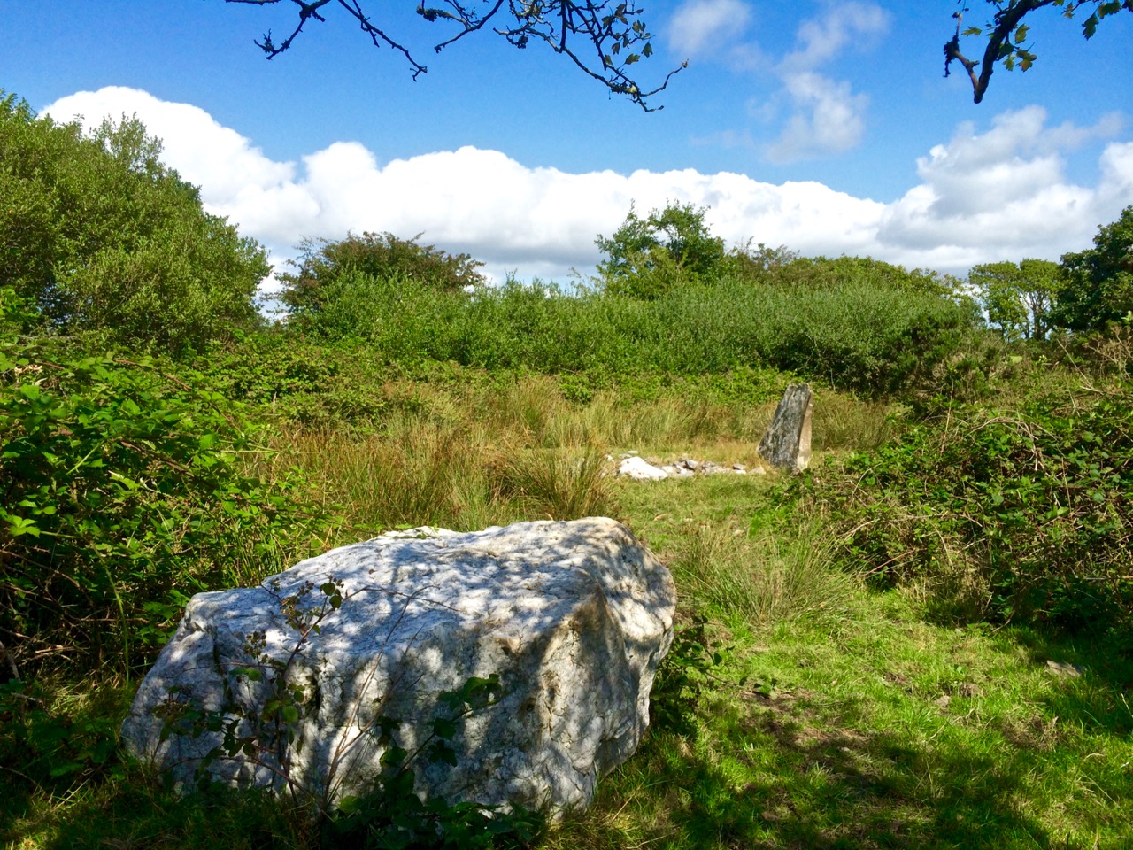
You will see immediately that Arderrawinny has all the attributes that make it instantly recognisable as a Portal Tomb – two tall upright stones mark the entrance (portal) and support the large front roofstone.

The portals are leaning quite perilously, but the whole edifice seems to be pretty well exactly as it was described by de Valera and O’Nualláín in their Survey of the Megalithic Tombs of Ireland conducted in the 70s, almost 50 years ago. (Vol IV, available here.)

Their observations was that The structure is incorporated into a low oval-shaped mound measuring 10.00m by 9.00m and rising to a maximum height of .7m. This ‘mound’ is faintly visible but the surrounding area has been heavily ‘improved’ over the years so that very little impression can be gained of what the context may have been in antiquity. 

Were Portal Tombs always covered by a cairn or mound? In his book The Prehistoric Archaeology of Ireland, John Waddell says they were, but many have been denuded. He adds, as far as can be judged from rather limited evidence, cairns are of elongated, perhaps subrectangular form, but short oval and round cairns also exist. The excavation at Poulnabrone revealed evidence of a low mound or cairn. Rather than covering the entire structure, this seemed to have functioned to provide lateral support to the orthostats, which sat directly on the bare limestone bedrock, kept in place by the sheer weight of the capstone. Interestingly, the reconstruction drawing for Proleek (below) illustrates an elongated mound/cairn covering the tomb, although no traces of such a mound have been found at that site.

Note that in this drawing, the capstone is still visible, above the cairn material. Others have postulated that Portal Tomb cairns were low, only reaching part way up the supporting orthostats. One scholar has also used lichen growth (lichens can be as 4,000 years old) to support this theory.

De Valera and O’Nualláín describe two overlapping roofstones at Arderrawinny, with the rear stones resting on a small sill which forms the backstone of the chamber. This rear capstone is now almost resting on the ground (above), although it is hard to see inside as stones, possibly from field clearance, have been tossed into the chamber. On our visit, only our junior archaeologists were able to worm their way inside.

What was the burial rite? Here’s what the Poulnabrone excavation revealed: 

The commingled unburnt remains of at least 35 individuals were recovered from the chamber, ranging in date from c. 3800 cal BC to c. 3200 cal BC. The earliest burials are likely to date to the time of the construction of the tomb which would place it at the very beginning of the Irish Neolithic. Successive interment of complete bodies appears to have been the burial rite practised, with subsequent displacement, removal and manipulation of the bones accounting for the disarticulation and jumbled state of the remains. Both male and female and all age groups are represented in the assemblage. A foetus of middle Bronze Age date was recovered from the portico. Analysis of the remains suggested a wholly terrestrial diet with limited consumption of animal protein and, with one exception, all individuals appear to have originated in the carboniferous limestone region of the Burren. A number of animal bones (including cattle, sheep, goat and pig) were intermingled with the human remains.

However, in other Portal Tombs the preference appears to have been for cremation. Waddell cites several examples of burnt bone from excavated Portal Tombs.

Arderrawinny, then, is probably the oldest archaeological monument on the Mizen. In West Cork there is one other Portal Tomb – at Ahaglaslin. If you have driven east along the N71 from Rosscarbery, you will have seen it – a distinct capstone on the side of the hill. 

This one was visited by Borlase as  far back as the 1890 and he described it in his book The Dolmens of Ireland. His illustration, and that of his another antiquarian, Windele, is given below.

Jack Roberts also illustrated it (below) for his marvellous series of books on West Cork antiquities. Jack always manages to capture the essence of these ancient monuments, clearing away distracting foliage, while still conveying the landscape.

Finally, although I haven’t visited it myself, the redoubtable David Myler has, and allowed me to use his photographs. As you can see, Ahaglaslin is similar to Arderrawinny, with the characteristics of the Portal Tomb clearly to be seen.

Curious features of both Arderawinny and Ahaglaslin are their location and orientation. While Arderawinny has a distant view of the sea to the south west, it is actually oriented – that is, the portals face towards – the cliff directly in front of it. To the north, in fact, with no possibility of any sunset/sunrise (unlike wedge tombs, in which entrances invariably point towards the setting sun). Similarly, although Ahaglaslin is  located only a kilometre to the sea, which is directly south, it is oriented up the slope of the hill, to the east. with no commanding view in that direction. 

We know that Neolithic people were masters of building to take advantage of sunrises and sunsets, and we assume this to be an important part of whatever belief-set they had. Given that, the non-orientation of these two West Cork Portal Tombs is a bit of a head-scratcher.

I will leave the last word on Portal Tombs to Waddell, since he sums it up beautifully. Although the portal tomb is invariably a structure of simple plan, he says, some of these monuments are remarkable examples of megalithic engineering.

Boulder Burials: a Misnamed Monument?

Rathruane Boulder Burial

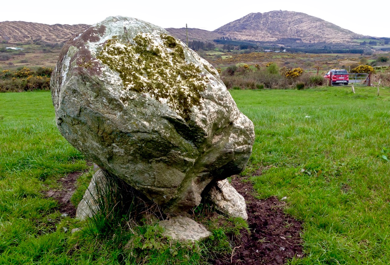
The term boulder burial was coined in the 1970s by Sean O’Nualláin, an archaeologist with the Ordnance Survey, to describe a class of monument that was quite prevalent in the south west, consisting of a single large boulder sitting on three or four support stones. The support stones lift the boulder off the ground and provide a small chamber-like area under the stone. Previously, this type of monument was known as a dolmen, a boulder dolmen or a cromlech, but O’Nualláin was convinced that the main purpose of these boulders was to mark a burial.

Lisheen Cromlechs by Jack Roberts

Illustrations from Jack Robert’s book Exploring West Cork

He based this belief partly on his extensive experience with other megalithic monuments, but also on the findings of the excavation of the Bohonagh complex, where Fahy found fragments of cremated bone in a pit under the boulder.

Bohonagh Boulder Burial
The Bohonagh complex includes a multiple-stone circle, a boulder burial and a cup-marked stone. A standing stone stood close by but has disappeared. Note the quartz support stone

However, William O’Brien excavated three boulder burials in the late 1980s and found no evidence of burials. In his book, Iverni, he comments in an understated way, “The absence of human remains at Cooradarrigan and Ballycommane does pose some questions as to their use.” His findings dated the sites to the Middle Bronze Age, between 3000 and 3,500 years ago.

Lisheen Lower boulder Burial

A boulder burial from Lisheen Lower

What is unquestioned, though, is that they are predominantly found in the south west, especially in Cork, and that, while most occur alone, they are often found in groups, and/or in association with stone circles or standing stones.

rathruane boulder

This one is at Rathruane More, close to a significant rock art site and with views of Mount Gabriel and Mount Corrin

A boulder burial is a striking and unmistakable sight. Often situated on a high point or ridge it can be seen silhouetted against the sky – a large glacial erratic standing proud in the landscape. There are lots of examples around us here and most of them command extensive and often panoramic views. These are monuments that were built to be seen and to see from.

dunmanus boulder burial

An exception to the high ground location is found at Dunmanus on the north side of the Mizen Peninsula. This boulder-burial is so low-lying, in fact, that one can only reach it at low tide

Ballycommane Bouder Burial quartz

Ballycommane – the boulder is of white quartz

William O’Brien has pointed out that quartz is a feature of West Cork prehistoric sites and this is particularly evident in the case of boulder-burials. At Bohonagh, for example, some of the support stones are of gleaming white quartz, while at Ballycommane, Cooradarrigan and Cullomane the boulder itself is quartz. The sun was low in the sky when we visited Ballycommane and the sight of the quartz boulder gently gleaming was truly memorable.

Mill Little Complex 2

The Mill Little complex

Boulder burials often occur in groups and in association with other monuments. Mill Little is a good example of this: three boulder burials are in a line with a standing stone pair at one end and a five-stone circle at the other. See our post Family-Friendly Archaeology Day for more photos of the Mill Little Complex.

Cullomane boulder burial

This photograph shows the Cullomane boulder burial in the foreground, and a ‘penitential station’, in the background. This ‘station’ was part of a pilgrim round that involved prayer and penance – see Holy Wells of Cork for more detail on this site

At the Cullomane site, east of Bantry, the quartz boulder is surrounded by a variety of other monuments: a small stone circle, an ‘anomolous’ group of stone, a stone row, and standing stones all lie within a few fields of each other. Intriguingly, this site has seen continued ritual use through the millennia – there are also ring forts, burial grounds, a holy well and a ‘penitential station’ within the same small area.

Ballycommane boulder burial and standing stone pair

The Ballycommane boulder is in close proximity to a standing stone pair

Breeny More 4

At Breeny More, near Kealkill, four boulder burials in a square pattern lie inside what remains of a large multiple-stone circle. This is an awe-inspiring site – you feel you are on top of the world with mountains all around and stunning views out to the end of the Beara and Sheep’s Head Peninsulas. See Robert’s post Walking the Past for a sense of what this site offers.

Kenmare Stone Circle and boulder burial

The Kenmare stone circle, above, has a boulder burial in the middle of it, while the Gorteanish stone circle on the Sheep’s Head, below, has at least one and possibly two boulder burials

Gorteanish

So – if they weren’t tombs, or weren’t solely tombs – what was the purpose of these striking boulders? Their association with stone circles and rows provide evidence that they fit the calendrical pattern that we find in so many monuments of this era. Mike Wilson, the archeo-astronomer of the Mega-What site, has surveyed many of the West Cork boulder burials and has this to say: This survey shows that boulder-monuments were functional objects marking astronomically important places in the landscape. They cannot generally define an azimuth as accurately as a stone row or circle but capstone shape and orientation are usually significant, helping to indicate directions of interest.

Breeny More

At Breeny More the square layout of the four boulder burials within the stone circle provide many possible alignments

In several of the boulder burials we have observed, capstone shape and direction certainly seem to be a deliberate feature of the monument.

Rathruane boulder Burial Orientation

Robert checks the orientation of the long axis of the capstone at Rathruane More

But perhaps the best example we have of how a boulder burial can have an orientation was drawn to our attention by local historian Brigid O’Brien – and she even sent us the evidence! If you stand at Bawngare, your attention is immediately drawn to the spectacular views to the west and north west – views that include Mount Gabriel, Mount Corrin and between them, faraway Hungry Hill on the Beara Peninsula, as well as the Sea in Roaringwater Bay. Interestingly, one of the support stones has several small shallow cupmarks (cupmarks are found on the capstones of several boulder burials).

Barngare Boulder Burial and view

The view west from Bawngare boulder burial

However the capstone with its distinctive long furrow holds the real secret, and Brigid’s persistence in braving the cold to visit at exactly the right time has unlocked that secret for us now.

Bawngare boulder burial general

From the other side the long furrow can be seen running the length of the capstone

Brigid visited it last year at the winter solstice and took this photograph of the setting sun. It seems the capstone was deliberately positioned to mark this alignment.

Bawngare boulder burial winter solstice sunset

Brigid’s photograph, taken on December 21st, 2015

Perhaps it’s time to go back to calling them something other than burials – I rather fancy the old term boulder dolmens. What do you think?

Were You at the Rock?

Mass rock along the Beara Way (see the look out above)

Mass rock along the Beara Way (see the lookout above)

An raibh tú ag an gCarraig? / Were You at the Rock?

nó a’ bhfaca tú féin mó grá / Or did you yourself see my love,

nó a’ bhfaca tú gile, / Or did you see a brightness,

finne agus scéimh na mná? / The fairness and the beauty of the woman?

This beautiful song speaks to a revered tradition in Irish history and folk custom – the mass rock. During the period of the Penal Laws (late 17th and first half of 18th Century) when the practice of Catholicism was outlawed, parishioners would gather at a secret location to attend mass. The priest travelled from community to community in disguise, a lookout was posted, and mass was celebrated on a lonely rock far from the reach of the law. The song encodes the message that the people still find ways to attend mass, despite the harsh prohibition against it.

Mass rocks are often in remote locations

Mass rocks are often in remote locations

Dr. Hilary Bishop, in her excellent website Find a Mass Rock says, “As locations of a distinctively Catholic faith, Mass Rocks are important religious and historical monuments that provide a tangible and experiential link to Irish heritage and tradition.” She also points out that, because of the imperative for secrecy, mass rocks are difficult to find. We certainly experienced this when we set out for a day of mass rock hunting recently. Working from a list generated from the National Monuments Service database we spent a day on the Sheep’s Head and the Mizen and had trouble finding all the rocks on the list. One, if it was still there, had disappeared under impenetrable layers of gorse. A second rock was last recorded in the 1980s: residents were no longer familiar with it.

Beach Holy Well and mass rock

Beach holy well and mass rock

Knowledge of mass rocks has passed down from generation to generation. In the deep countryside, the sites maintain a mystique and a sense of the sacred. Last year we wrote about the mass rock and holy well at Beach, where Mary conjured up a blanket of fog to confuse the English soldiers and allow the priest to escape. At Beach and at our first stop, the mass rock at Glanalin on the Sheep’s Head Way, mass is still celebrated occasionally.

The Glanalin rock, and the one we visited on the Beara Peninsula, are good examples of the remote locations typical of many mass rocks, high on a hillside or hidden in an isolated valley. You can picture the procession of worshippers, in ones and twos, slipping silently through the bracken, pausing to make sure they are not being watched, climbing higher, following an overgrown trail, arriving at the meeting place where the hushed crowd awaits the arrival of the priest.

Beara mass rock

Beara mass rock

One of the rocks we found looked for all the world like a fallen standing stone – and that’s probably what it was. (I wonder if I should go to confession, though – I’m sure that sitting on a mass rock would qualify as at least a venial sin.)

Fallen standing stone?  Mass rock? Both?

Fallen standing stone? Mass rock? Both?

A mass rock that is easily visited is the one at Cononagh Village, right at the side of the main road into West Cork, the N71. This site is beautifully maintained – Cononagh is obviously proud of its heritage: signage and flowers invite the passerby to take a closer look.

Another easily accessible site is Altar, at Toormore. This is a wedge tomb, probably over 4,000 years old and excavated in 1989. It remained in use through the Bronze Age and into the Iron Age. Dr. William O’Brien, in his book on the archaeology of County Cork, Iverni, says of this site: “…over time this tomb came to be regarded as a sacred place, housing important ancestral remains in what was a type of community shrine.” How fitting, then, that the flat capstone of the Altar wedge tomb became, in the Penal Days, a mass rock. And how intriguing to think of the continuation of this sacred space over the course of thousands of years.

Altar Wedge Tomb, later used as a mass rock

Altar Wedge Tomb, later used as a mass rock