Tralong Bay, Co Cork – A Prehistoric Drowned Landscape

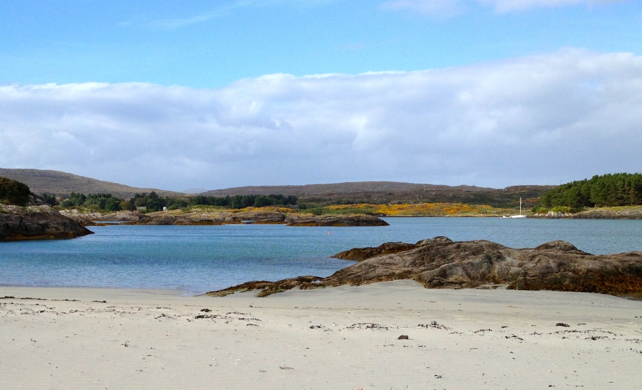
In West Cork it is possible to examine the remains of trees which were growing several thousand years ago – perhaps in the time of our earliest ancestors. Around the coasts of Ireland and Britain are sites of post-glacial forests which flourished close to an ancient shoreline until inundated by rising sea levels in the Neolithic period. Cycles of change in weather, tides and geology over millennia saw these remains flooded by encroaching seas, then resurfacing, only to be buried under sediment and sand as tides abated. We are living in an age of extremes and recent abnormal climate activity has in places exposed some of these remains which are as old as human activity in Ireland: this is Organic Archaeology!

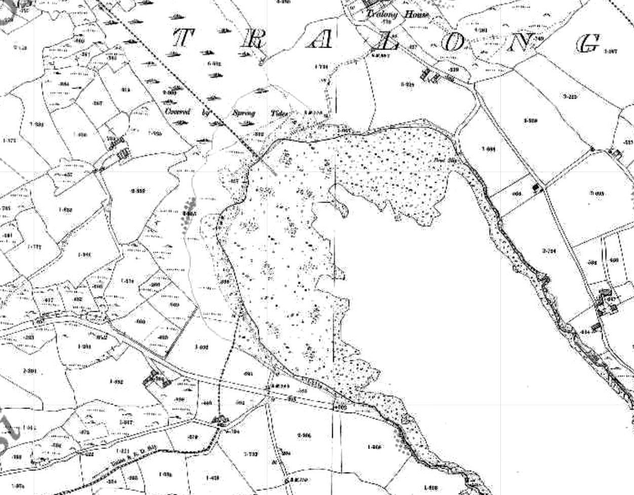
Header – Tralong Beach, between Glandore and Rosscarbery, where the remains of very ancient woodland can be seen. Upper map – the c1850 6″ OS map showing the shape of the coastline at Tralong Bay, and Lower map – a closer aerial view of the beach in modern times: the darker mass shows the partly submerged peat beds

Little has been written about the Tralong site, but another comparable drowned landscape has been revealed in Northumberland UK where archaeologist Clive Waddington, of the company Archaeology Research Services, has found the remains of an ancient forest on the coast of Low Hauxley. He reports:

. . . In 5,000 BC, the sea level rose rapidly and swallowed the earth. The sand dunes were pushed inland, burying the forest, and then the sea receded somewhat. Now, the sea level increases again: it cuts out the sand dunes and exposes the forest . . . During the course of the investigation, the archaeologists found evidence of human presence in the area: traces of adults and children , the analysis of which revealed that they were wearing leather footwear. With human footprints the scientists also found footprints of wild boar and brown bears . . .

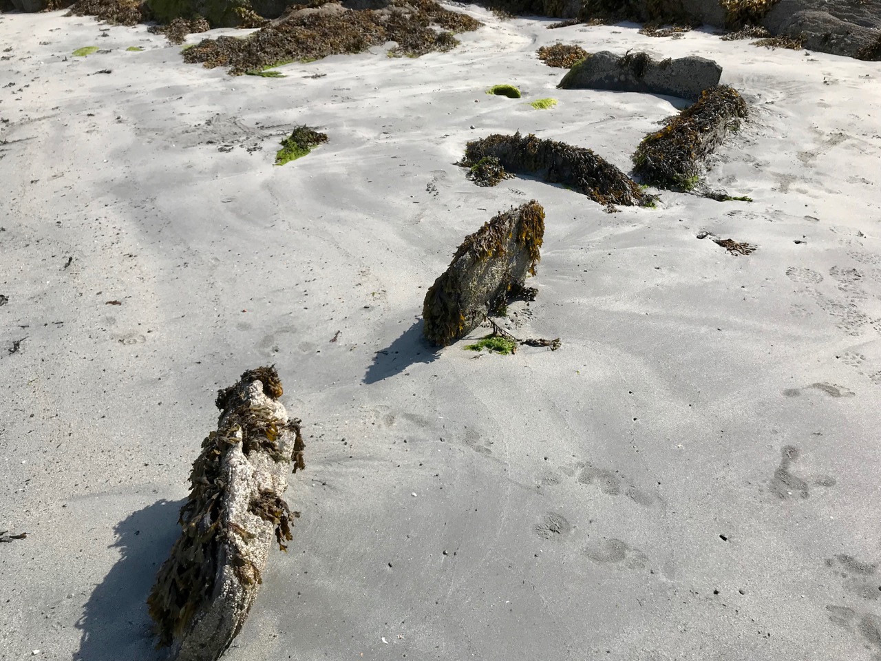
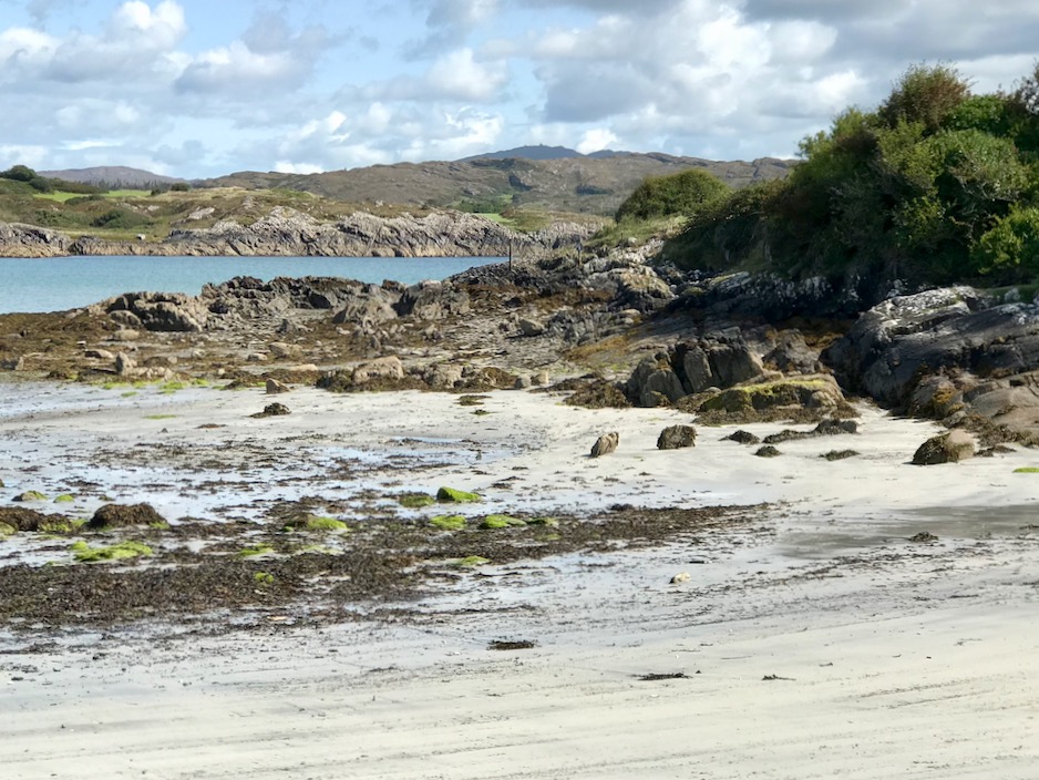
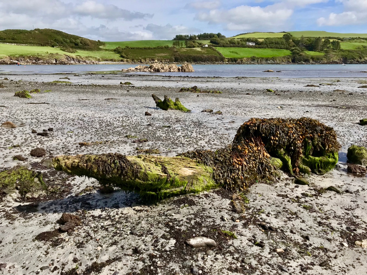
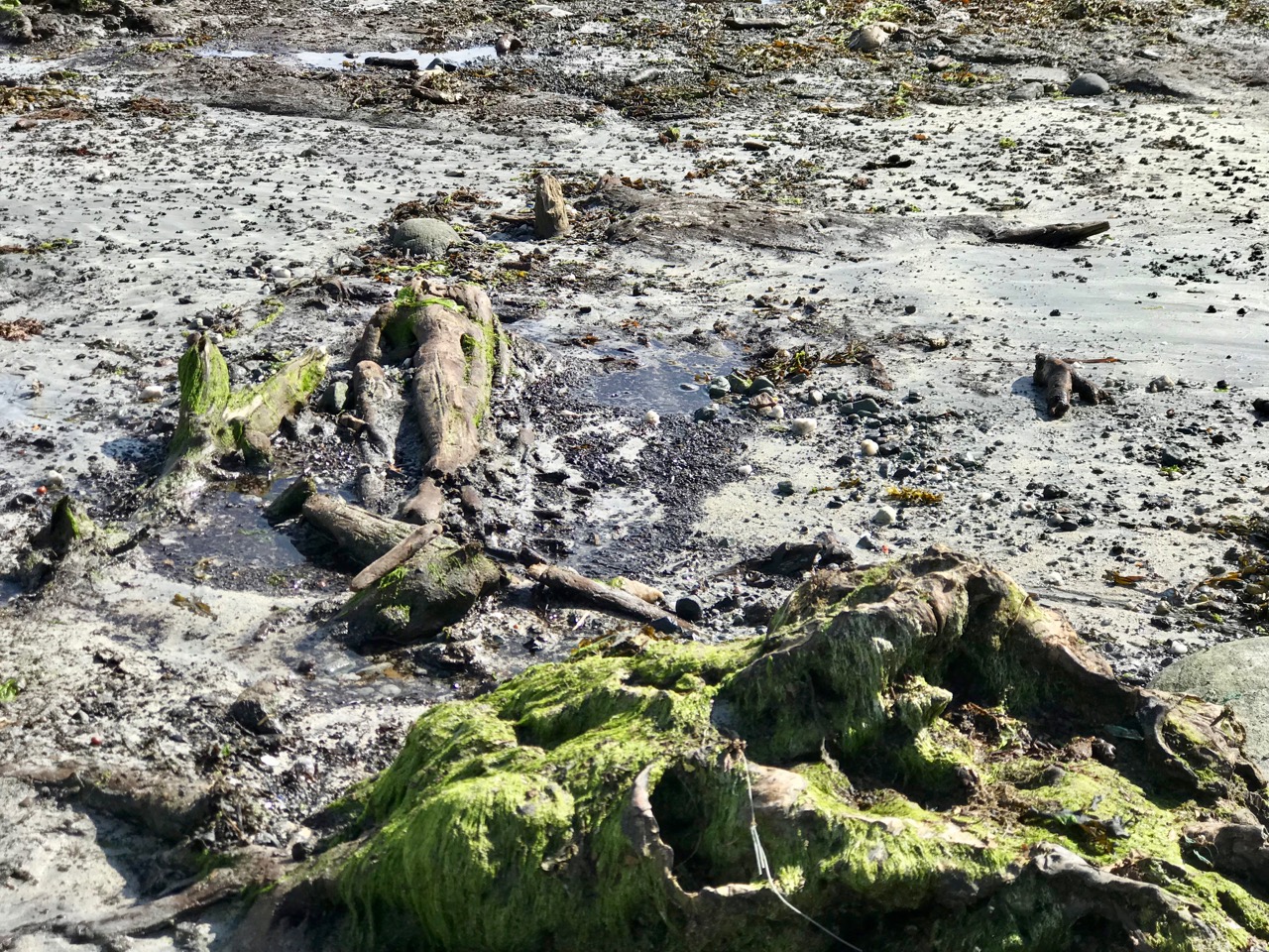
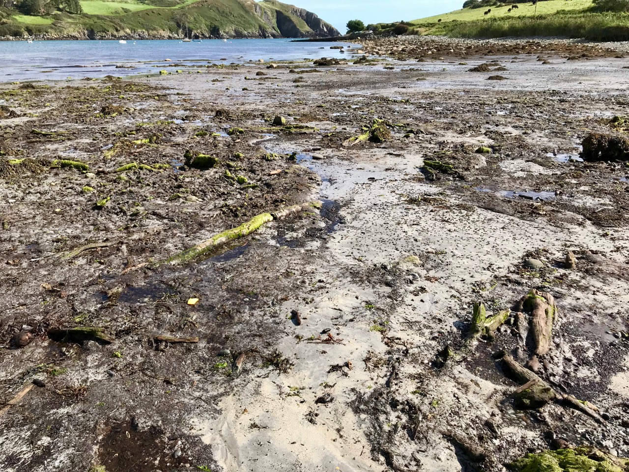
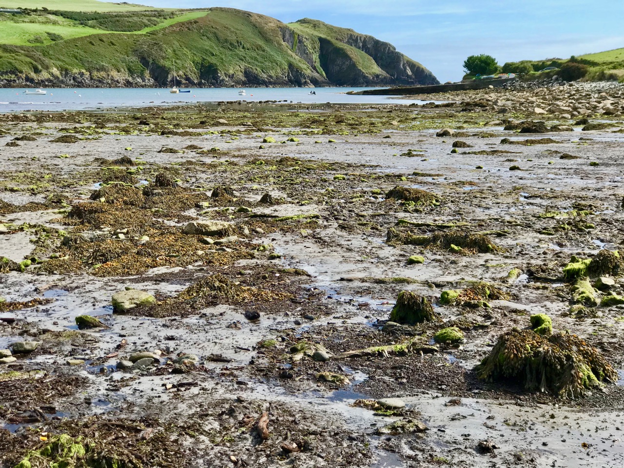
Part of the beach at Tralong Bay, Co Cork: the surface of the peat mass, which could be up to 4 metres thick, is interspersed with numerous tree boles, roots and scattered branch and twig debris. At one place I found a perfect complete pine cone, which could have been part of that debris.

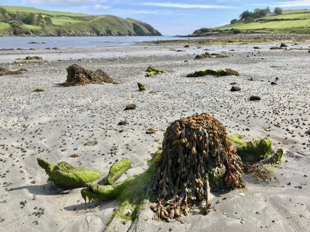
The surface of the beach is dotted with these remnants of ancient forest, over a wide area. It seems remarkable that there are also extensive blankets of loose material retained in the bay which must also originate from the forest.

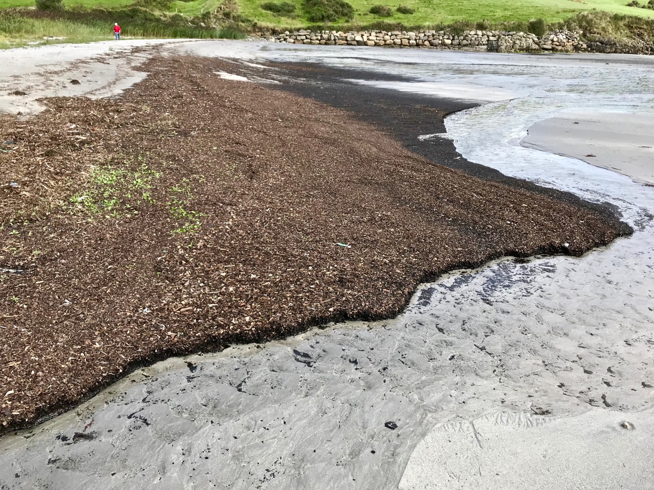
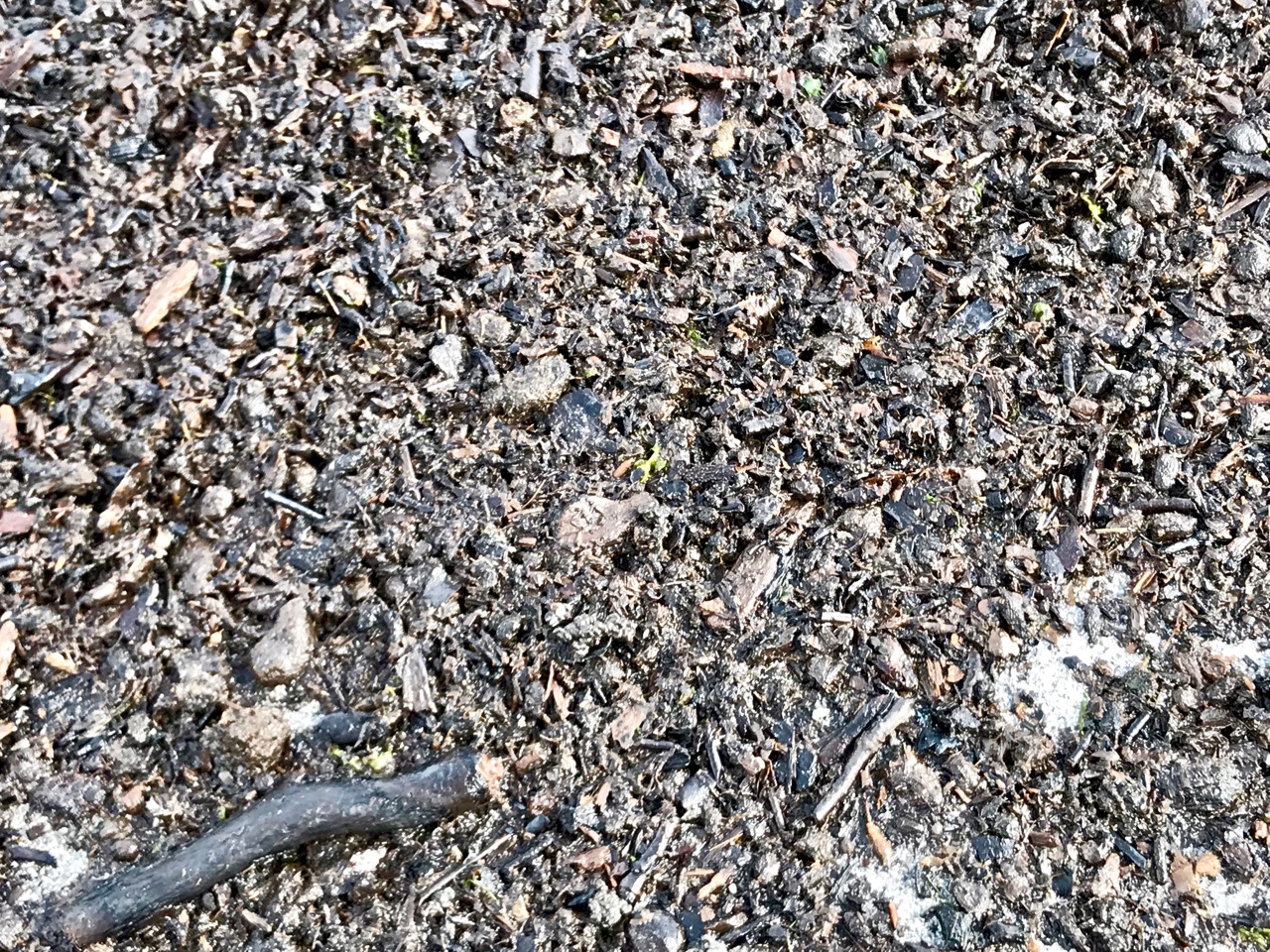
Upper picture – one of the huge blankets of organic material – mainly wood based – which has been washed up to the north end of the bay at Tralong since the extreme storms of 2014. Lower pictures – closer views of the debris showing recognisable material including twigs and branches.

In November 2015 Michael Viney wrote a piece in the Irish Times on drowned forests in Galway Bay:

. . . All summer the quiet tides returned the sand that last winter’s storms had dragged offshore, heaping it even deeper over the old oaken wreck on the strand . . . Perhaps, though I hope not, this winter’s great mill wheels of waves will grind that deeply again. Storms two years ago tore away whole layers of sand and stone west of Spiddal in Galway Bay, uncovering stumps of ancient oak, pine and birch from a 7,000-year-old forest drowned as the sea rose after the end of the Ice Age. The same exceptional seas, on the north coast of Connemara, exposed remnants of human occupation a metre thick in the sand-cliff shore of Omey Island. There were medieval burials among them, and bog at least 6,000 years old . . . Elsewhere along the west coast yet more of the kitchen shell middens of early settlers, back to the late Mesolithic, were stripped away. So the sea reveals the past and then takes it away . . . Glimpses of Ireland’s lost shores and drowned forests are not new. Pinewoods submerged off the Bray coast were described by Robert Lloyd Praeger at the end of the 19th century when construction of Bray harbour changed sediment flows and piles of collapsed trees appeared above the sand . . .

Ancient forests reappeared again in Bray, Co Wicklow, in 2001, and more were revealed recently – in 2017. The Irish Times reported earlier this year on a project to discover “the lost landscapes” of the Irish Sea

Tralong Beach will change again, as the weather patterns vary, and it may not always be possible to experience the drowned landscape here. It’s an unmissable journey into deep history.

With many thanks to Robin Lewando for introducing us to this site, and to Anthony Beese for providing additional material

Ballyrisode – Pirate Connections

Last week, Finola wrote about the discovery of what is probably an intertidal fulacht fia on the beach at Ballyrisode, not too far west of us down the Mizen Peninsula. Following the publication of her post, we received a host of comments and messages, including from our friend Dr Connie Kelleher – an underwater archaeologist and well-known specialist on the history of piracy in West Cork. Connie told us that she and a colleague – Áine Brosnan – had examined the site back in 2012 because they were looking for links to pirate connections!

Header – this really is the colour of the remarkably clear water in Canty’s Cove seen on a recent visit: this is probably due to veins of copper ore. Above – Ballyrisode Strand is notable for its secluded location and its impressive white sand

The mention of pirates took me back to my 2016 post – Cantyclick here now and have a read, then return to this page for more insights. One of my resources when researching for Canty was an article by John Hawke in Volume 5 of the Mizen Journal, published in 1997: Canty’s Cove – Legend and History. I only used snippets in my post then, as I concentrated on Canty’s lair on the Northside. Today I’ll expand on Canty’s exploits to the south and west, including his connections with Ballyrisode. Connie made a very valuable point in her comments to us that Canty was a Gaelic-Irish pirate on the opposite side of the peninsula to William Hull and active at a time when the English pirates were headquartered in Leamcon, Baltimore and Crookhaven; he appears to have remained in control within his own domain to at least 1629 but most probably into the 1640s.

Upper – a photo from ‘Northside of the Mizen’ clearly showing the protected promontory known as ‘Canty’s Garden’ in the twentieth century. It is likely that this is the site of Dunkelly Castle, and was the scene of Canty’s grisly treatment of his visitors. Lower – looking across Canty’s Garden today

The following stories were told to John Hawke in 1995 by James Camier, and were handed down from his father, William Camier of Enaghoughter Townland: they therefore go back a good few generations:

. . . Boats from America and elsewhere came into Dunmanus Bay, the captains were invited into his house by Canty, were dazzled by a special grog, robbed and pushed through the north door over the cliff into the cove to the north. On one occasion Canty wanted to stop an invasion by some outsiders at Ballyrisode. He had a daughter, who did not want him to go and tried to stop him, so he shot her. He then crossed by land to Ballyrisode and by moonlight fought a battle on the first strand, which he won. Gravestones to the dead stood on the shore. One day, the son of a captain previously murdered by Canty, who was also a captain, on returning from America was invited in by Canty. But, knowing more than his father, when Canty asked him to step outside he pushed Canty over the cliff . . . James himself remembers some gravestones, but these have been covered by encroaching sand over recent years . . . Graves existing on the second strand are of drowned sailors . . .

Sailor’s graves – or the site of a pirate battle? The fulacht fia is upper right in this picture

This very categoric piece of information suggests that James Camier (or perhaps his father) attribute the stones on the ‘second strand’ to sailors’ graves. These stones are probably the small upright stones which lie close to the fulacht fia today: they certainly resemble grave markers in size and shape. In the context of a Bronze Age fulacht fia such stones were probably part of a hearth or roasting-pit.

It is illegal to disturb any archaeological site (please note!). Our activities at Ballysrisode were confined to measuring and photography. However, we made a series of probes across the beach to test the depth of the sand (and imagine how many excavations have been made on that beach over the years by eager sandcastle engineers!). Our results show that there seems to be a consistent depth of only 50mm to 200mm over the main beach. Hmmmm… not enough to bury any pirate bones methinks. Also, it’s rather unlikely that any pirates would stay around to firmly fix substantial stone markers over the graves of their dead comrades (or enemies). But I would never want to stand in the way of a good tale.

I know this is slightly ‘off subject’ but it’s worth adding to the whole picture of Canty and pirates another tale from the Camiers:

. . . Canty’s Cove was always seen in the locality as a lonesome place at night and there are various stories of unexplained sightings – old longboats coming in and out, a man walking along the ledge on the far side of the Cove from the pier and suddenly disappearing, and of “white” hands helping the captain to tie up his seine boat . . .

I’m not sure that I’d be up for a visit to Canty’s Cove after sunset (above), but the beautiful white strands at Ballyrisode would be most attractive in the moonlight, and – who knows – it might be a good time to see if there is any ghostly pirate activity in this historically significant place.

In the picture below Rosie the Dog investigates the apparently haunted piers at Canty’s Cove: they were extensively upgraded in the 1940s

Ballyrisode Fulacht Fia: Discovering a New Bronze Age Site on The Mizen

Hidden in plain site – that’s how we stumbled across a hitherto unrecorded archaeological site at Ballyrisode Beach. It’s a popular swimming place, often swarming with swimmers, sun-bathers and picnickers in the summer and enjoyed by dog-walkers in the winter. Like many others, we were simply enjoying being at the water on a warm day when Robert drew my attention to an odd grouping of stones.

Three sides of a rectangle were defined by stone slabs laid on their sides in the sand, while two other upright slabs stood close by.

It had all the appearance of a carefully constructed trough, with one side missing, and it immediately reminded us of the cooking site at Drombeg Stone Circle.

Drombeg – besides the famous stone circle there is a hut site and this – a water-boiling trough with associated hearth and well, surrounded by a horseshoe-shaped mound of stone. An interpretive panel illustrates its use.

I took photographs and posted them to an online forum with a request for more information. An answer came back immediately, from a group of archaeologists who had excavated an almost-identical site in Sligo – what we were looking at was indeed an intertidal fulacht fia (full oct fee-ah, pl: fulachtaí fia/full octee fee-ah)).

E M Fahy excavated Drombeg in 1958 and returned the next year to dig the fulacht fia. This is his site drawing of the fulacht fia. You can read his original report here.

What exactly is a fulacht fia? The name translates as a wild cooking place and it was coined to describe this kind of open air kitchen. In Britain they are known as Burnt Mounds. Typically, they consist of a trough, normally lined with stone but occasionally with wood. The water in the trough was brought to a boil by dropping very hot stones into it, and therefore another feature of a fulacht fia is a hearth for heating the stones. Once the stones were used up (after heating and cooling one or more times they cracked and broke) they were tossed aside and over time a horseshoe-shaped mound of these burnt and shattered stones accumulated around the trough.

Another site drawing of a fulacht fia – this one was in Ballyvourney, excavated by Michael J O’Kelly in the 1950’s (report available here). Observe the numerous slabs laid on their sides around the trough – some for the roasting pit and some for the hearth. The two upright slabs at Ballyrisode are likely to have been part of such a related grouping of stones

Fulachtaí fia, in fact, are the most numerous archaeological sites in Cork, with 3,000 recorded sites, although they are known all over Ireland and in Britain and Northern Europe. Prof William O’Brien, in Iverni, refers to them as ‘water-boiling sites’ which is a more accurate description, since we don’t actually have overwhelming evidence that they were used for cooking. Few bones have been found among the burnt stones at some sites, although this is often explained away by reference to acidic soils and poor bone preservation.

Trinity Well, near Newmarket in North Cork, is a Bronze Age fulacht fia that has been re-purposed in modern times as a holy well! Read more about this site in Holy Wells of Cork

So the question remains open as to their purpose or purposes and proposals include their use for tanning and brewing. It is also possible they may have been used for bathing, or incorporated into sweat-house rituals.

From Prof O’Kelly’s report on his excavations come these photographs of his cooking experiments

We do tend to think of them as cooking-places, though, largely because of the experimental work carried out by Prof Michael J O’Kelly in the 50’s. I remember him telling us about it when I was a student in his classes and I can still see the obvious relish with which he described the juicy leg of mutton that emerged from the simmering trough after almost four hours (they used the 20 minutes to the lb and 20 left over formula) and how clean the meat was when unwrapped from its straw casing.

But the brewing argument is compelling too – just take a look at this experiment by two archaeologists making ‘a prehistoric home brew!’

But what about a site like our one, half buried in the sand? It turns out that there’s a similar one in Cork at Lispatrick on Courtmacsherry Bay, that was visible when first discovered at low tide but underwater at high (see note from Jerome Lordan in the comments). Thanks to Alan Hawkes for alerting me to that one. Alan is the author of The Archaeology of Prehistoric Burnt Mounds in Ireland, the most comprehensive study of fulacht fia ever undertaken.

This photograph of the Lispatrick site is taken from Iverni

There’s another one at Creedon in Waterford (below) and that one is made of wood – thanks to Simon Dowling for sending me a 3D image of it (not shown), showing toolmarks on the wood

The wooden trough of the fulacht fia at Creedon Beach in Co Waterford, discovered by local historian Noel MacDonagh (photographer unknown)

Possibly the most helpful site to use as a comparison to Ballyrisode is the inter-tidal fulacht fia from Coney Island in Sligo. We are fortunate that the site was thoroughly analysed by James Bonsall and Marion Dowd of IT Sligo, and the results published in The Journal of Irish Archaeology in 2015 and available through JSTOR. (Thank you for the link, James Bonsall.) Ciarán Davis found the site and also participated in the excavation and he has kindly shared some of his photographs with me. Thank you, Ciarán!*

This and the following two photographs are of the Coney Island (Sligo) sites, kindly shared by Ciarán Davis

Like Ballyrisode, the trough is stone-lined and full of sand from the movement of the tide, which covers it at high tide. It was dated using a charcoal layer beneath the floor slab, to the Late Bronze Age (making it about three thousand years old).

The flat slab at bottom right has been interpreted as a kneeling stone – such stones have been observed elsewhere

The authors point out that it is impossible to tell whether the intertidal location of many such sites is a planned feature, or whether they were originally on dry land and have ended up in the intertidal zone due to erosion or shifting sea levels.  However, at Coney Island it seemed clear that the fulacht fia had been deliberately constructed such that it filled with water at high tide and held that water for several hours afterwards. The presence of a nearby midden indicated that this fulacht fia may indeed have been used to boil fish and shellfish in salt water – an efficient (and delicious!) method of cooking seafood.

So there you have it – an exciting new discovery to add to the archaeology of West Cork! This summer has seen incredible new finds in the Boyne Valley, due to the unusually dry weather and the emerging technology of drone photography. While our find is not in the league of a Dronehenge, it’s always good to know that there is still lots to discover in the wonderful West Cork landscape.

*As you can see with all the thank yous, archaeologists have been very generous in sharing information with me about intertidal fulacht fia. I am grateful for this supportive online community as I try to catch up on the forty years of archaeological research that I missed while in Canada.

A Flying Priest, and Rolls of Butter

Last week Finola reported on a journey over the mountains on the ‘Priest’s Leap’ road from Kenmare, Co Kerry to Bantry, in West Cork. We received a fusilade of comments from readers who told us we hadn’t seen half of what there is to be found on this road so, on the very first day of September, we were off again, this time getting a different perspective by travelling the other way. Before we left Bantry we had to find the very spot where the priest – being pursued by soldiers – landed after he and his horse leapt off the highest summit of the road which has been named after him.

It’s great that this stone has been left untouched by the modern roadmakers, so that all can see the hoof marks to this day. I calculated that, 400 years ago, the priest was airborne for a distance of some 12 kilometres as the crow (or horse!) flies – considerably more than some of those early aviators of the 20th century were credited with!

If you are not of a nervous disposition, and don’t mind travelling a narrow, single-track mountain road for some 15 kilometres, probably sharing it only with a few sheep, then to pass over this route is one of Ireland’s most spectacular experiences. Choose your day, though: we were lucky to have hot sun and clear views the whole way. If you survive it to the top, you are right on the Cork – Kerry border: in the photo below, the fence going on up the hill is exactly on that border line (and the point at which the priest and his horse took off is to the right of it at the peak). Stop and look around: the views in every direction are stunning.

After we crossed the border into Kerry we came downhill and stopped again at the remote, picturesque Feaghna burial ground in the townland of Garranes. On our last visit we were completely unaware of the existence of an unusual archaeological site nearby – one which has a number of traditions associated with it.

Popularly known as the ‘Rolls of Butter’ this site is technically a ‘Bullaun Stone’. These are fairly widespread over Ireland, but their original function is not known for sure. Here’s a summary from the National Monuments Service:

. . . The term ‘bullaun’ (from the Irish word ‘bullán’, which means a round hollow in a stone, or a bowl) is applied to boulders of stone or bedrock with hemispherical hollows or basin-like depressions, which may have functioned as mortars. They are frequently associated with ecclesiastical sites and holy wells and so may have been used for religious purposes. Other examples which do not appear to have ecclesiastical associations can be found in bedrock or outcrop in upland contexts, often under blanket bog, and are known as bedrock mortars. They date from the prehistoric period to the early medieval period  . . .

A drawing by the 19th century antiquarian W F Wakeman of a Bullaun Stone at Killinagh in Co Cavan. Here, the stones are known as ‘cursing stones’ – a term also applied by some commentators to the Feaghna site at Garranes. Interestingly, the Cavan site is also referred to as ‘St Brigid’s Stones’, while the Rolls of Butter are associated with the local saint, Fiachna. Beliefs – stories – are, of course, as fascinating as any archaeological evidence, and have to be investigated. Here, they abound – and are best learned from local sources: in this link folklorist Matt Sullivan has put together an entertaining selection of local opinion about the Rolls of Butter.

A few years ago I wrote a post covering some bullauns, ‘cursing stones’ and ‘curing stones’ – but at that time I wasn’t aware of these examples just a mere priest’s leap away from our own home.

There is much more archaeology and history in this mountainous country: here (above) in the townland of Erneen, the view from the road across one of the many remote glens shows up former enclosures and ‘hut sites’, which the National Monuments Service describes thus:

. . . A structure, usually discernible as a low, stone foundation or earthen bank enclosing a circular, oval or subrectangular area, generally less then 5m in maximum dimension. The remains are generally too insubstantial to classify as a house but the majority probably functioned as dwellings. These may date to any period from prehistory (c. 8000 BC – AD 400) to the medieval period (5th-16th centuries AD) . . .

It’s intriguing to think that these beautiful natural landscapes which appear so lonely to us were occupied hundreds – perhaps thousands – of years ago. It’s likely that they have changed very little over all that time: history is clearly set out for us as we travel over this ancient way.

The days are shortening, and we still didn’t have time to explore everything the Priest’s Leap road has to reveal. We’ll be back again before too long – in search of more stories.

Out in the Field

During the West Cork History Festival field trips, led by Roaringwater Journal last week, treats were in store. Many thanks to volunteers Jenny and Ray who worked hard to provide the refreshments (and who baked the scones!) on Friday’s ‘Art and The Great Famine’ excursion, which arrived at Reen Farm in time for tea.

Artist John Kelly‘s cows are abundant at his home at Reen, and the experience of the connections with this unique place and Famine times were admirably and sensitively presented by Siobhan Burke of West Cork Experiences (she’s on the left, facing the bronze tree, below).

The day included organised visits to the 110 Skibbereen Girls project at the old workhouse site in Skibbereen – where we were given a presentation by artist Toma McCullim – and a guided tour by West Cork Arts Centre’s Zenda Williams of the Coming Home – Art and The Great Hunger exhibition at Uillinn, followed by a visit to the mass famine graves in Abbeystrewery, where Philip O’Reagan of the Skibbereen Heritage Centre explained the site’s enormous significance. Just as well we had those scones to bolster us up!

On the previous day we began the ‘West Cork Archaeology’ tour at Knockdrum Fort, where – in benevolent weather – you get the most spectacular views (above). Finola talked about the Rock Art on the site, which takes it back in time perhaps 5,000 years, and she also explained about the alignment with the Bealtaine sunset discovered by Boyle Somerville, described here – and which we witnessed ourselves earlier this year (below).

Highlights of that day’s expedition also included an entertaining time at Castletownshend hosted by George Salter-Townshend (below, he’s leading us into the Castle which has been owned by his family since medieval times).

After more on archeoastronomy from Finola, at Drombeg Stone Circle (above), a further treat was in store at Castle Salem, near Rosscarbery, where we were given a tour and talk by its owner Peter Daly (below).

We were delighted to be given the opportunity to provide this ‘lead-in’ to the History Festival weekend itself which – as last year – was a roaring success. If you didn’t go to it, take a look at the festival programme, and see what you missed!

Because our time has been taken up with the festival we haven’t written any posts this weekend. Normal service will be resumed next week. I can’t resist finishing off with another look at John Kelly’s sculpture garden at Reen.

Keith Payne’s Early Marks

The Gallery in the Burren College of Art in Ballyvaughan, Co Clare, recently opened an extraordinary exhibition by Keith Payne – Early Marks is a summation of Keith’s own insights into the beginnings of art and the possible source of a prehistoric worldwide visual language.

Keith Payne (left) and friend

We worked closely with Keith on our Rock Art Exhibition – long-term readers will remember his enormous and colourful depiction of the rock art at Derreennaclogh which lent so much visual impact to the exhibition and it’s included in this show as well. In addition we have seen individual pieces from this collection in Schull’s Blue House Gallery shows so we knew his interest in early art of all kinds. But individual paintings and sculptures, impressive as they are, are one thing – an integrated vision is something entirely different.

Keith’s Derreennaclogh painting is on the right – but what are those antlers all about? You’ll have to check that out for yourselves

And that is what we get at the Burren show – Keith’s long preoccupation with archaeology, anthropology and early art come together in a stunning sequence of artworks that lead the viewer not just through time and space (he provides a ‘Genographic map of the Human Emergence’ that shows the location of the inspiration for each piece) but also into that part of the human psyche that has always striven to communicate through art.

Robert contemplates the Venus of Laussel (above) and filiform (scratched or incised designs) occur throughout the world

We don’t know, of course, what some of these Early Marks meant. On one canvas Keith shows how a piece of ochre from Blombos Cave in South Africa (below) was engraved with diagonal scratch marks over 75,000 years ago. Our brains leap to provide an interpretation of such marks – to the modern mind, they must mean something – a tally, perhaps, or a primitive alphabet. We will probably never know exactly, but what we can deduce from such early markings and from all of the art that Keith shows us is that symbolic intent was embedded in the human cultural experience from the earliest times.

Faithful as they are to their models – Keith depicts cave paintings, rock scribings, Irish rock art, masks, a Venus figure, finger flutings – these are not copies of the originals, but come also from Keith’s deep knowledge of prehistoric and primitive art and from his own aesthetic imagination.

Finger fluting – when fingers are used to make marks on soft clay deposits on cave walls. Torchlight moving across the wall would have given life and movement to the images

In a pair of paintings with almost 3D tactility he shows how two handaxes represent a startling continuity of technology – one comes from Olduvai Gorge and dates from one and half million years. The other comes from England and dates to about 400,000 years. But identical handaxes have been found in sites that date to 40,000 years. A useful tool and a reliable technology persisted over time and produced these beautiful objects that truly united form and function.

For Keith, early marks spring from the visionary state which was part of the everyday ethos of early humans. His exhibition notes talk about ‘animism’ – a belief that that all things animate and inanimate have an intention of their own where there is no boundary between the physical world and the spiritual or ‘Other’ world.

Physical and cultural evolution are underlying themes in the exhibition

Those of us privileged to be at the opening were struck, individually and collectively, by the continuity of the human imagination over time. Curiously, the works seem to bring us together as a species, reminding us of common threads woven through our collective consciousness over the millennia.

Title: When the Great Door Opens – Turn Left

Louise Janvier, an artist, art historian and lecturer, who opened the exhibition summed it up this way in her erudite remarks: The work has literally been brought out of the darkness and into the light to reveal the ‘Animism’ of thought and with antiquarian curiosity stir the imagination to further contemplate on the nature of being. . . We can receive the offering and experience the closeness of the ancient world then absorb it as a visionary gift.

I will leave you with a final example of this ‘visionary gift.’ In this piece, from the perspective of a hunter hiding in an enormous cavern Keith views a herd of Woolly Mammoth passing by the cave entrance. The mammoths are rendered in true cave-painting style, leading the viewer into all kinds of rumination about the nature of these early depictions.

A trip to the Burren is a great experience at any time – make it before September 7th and catch this wonderful exhibition!