Dunworley Promontory Fort – A Bit Of A Stunner

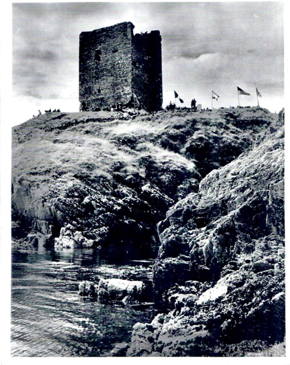
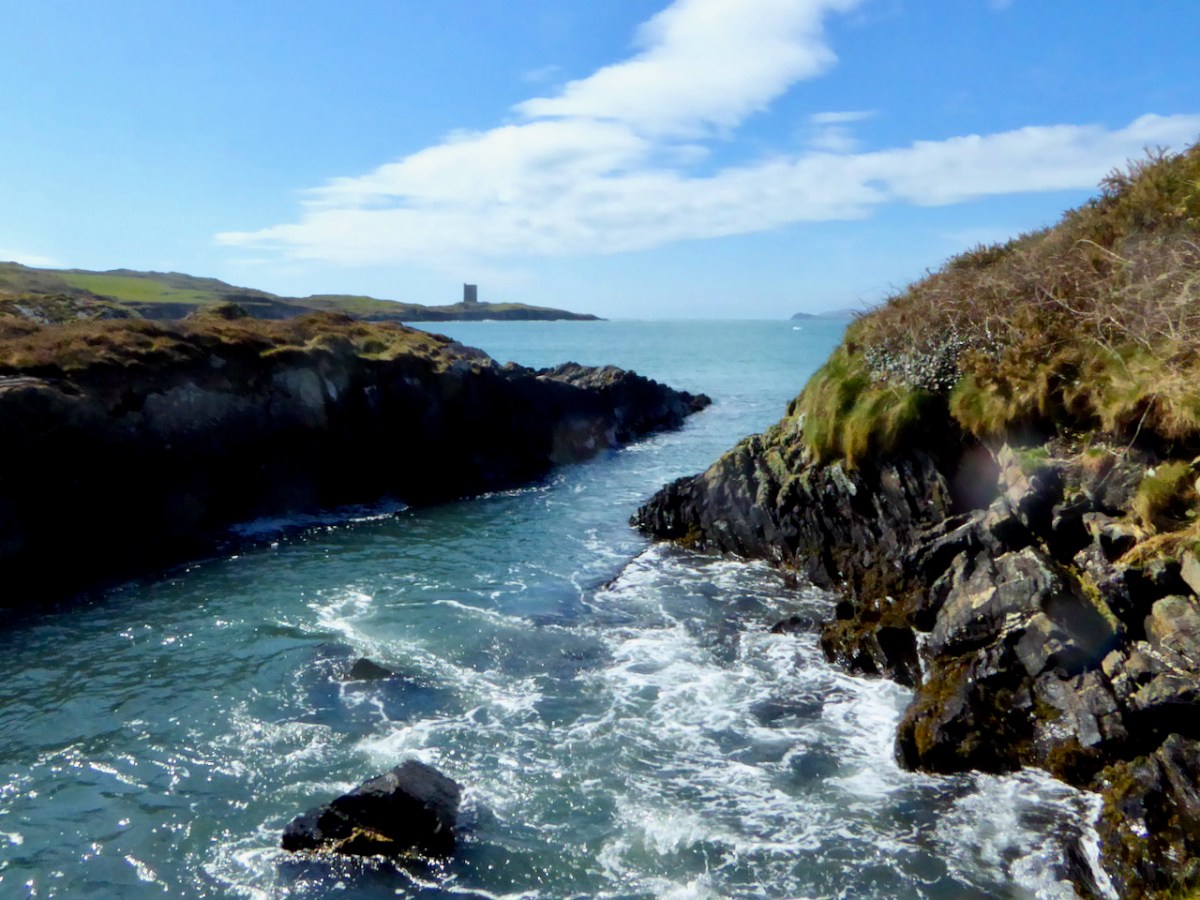
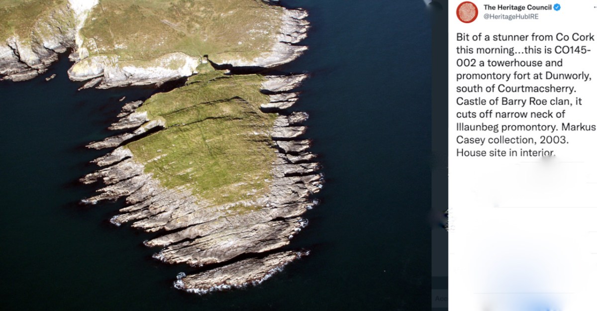
We’ve been wanting to visit this site for ages and the opportunity came this week, thanks to the kindness of Diarmuid Kingston and Tim Feen of Dúchas/the Clonakilty Historical Society, and the landowner, Jim Molony. As the Heritage Council said when they posted the photo below on their Twitter account – it’s a bit of a stunner!

Partly, this outing was to kick off a project I have in mind to follow in the footsteps, 100 years later, of Thomas J Westropp, the antiquarian who did so much to modernise Irish Archaeology and whose special interest was forts and fortified headlands. I already wrote about one of the promontory forts that he documented and we visited last year – Gouladoo, on the Sheep’s Head. I suppose that was In the Footsteps of Westropp 1, Part 1, and this is Part 2. 

Let’s review what a promontory fort is. In 2004 Liam Downey laid out the thinking on this type of monument for the Archaeology Ireland/Wordwell Heritage Guide series. He called them ‘enigmatic.’ They are headlands fortified at the narrowest part, or neck, by earth or stone banks, ditches or walls and they vary considerably in the size of the enclosed area and the length of the fortifications. The sea and the cliffs all around the enclosure provide another level of defence, often seemingly impregnable. 

This type of fortification may have been built as early as the Bronze Age, although most are believed to date to the Iron Age (from 500BC) or the Early Medieval Period (from 450AD), but many were obviously also occupied in the medieval period, when additional defences were added, as at Dunworley. 

Why were they built? Downey says this:

Their overtly defensive character and exposed locations, allied to the admittedly scarce excavation evidence, suggest that they might have been built as temporary refuges for use in times of grave danger. On the other hand, assuming that defence was the purpose, the cliff-top location suggests a fight to the death rather than a safe refuge. Assuming that human nature does not change radically from one era to another, one potential explanation for the location is prestige. Several promontory forts are built on a large scale and some are very impressive in appearance, especially those with closely spaced walls or banks. These may have been status sites, visible from a distance and designed to dominate the adjacent countryside. The spectacular locations, unspoiled sea views, occasional associations with royalty, pagan deities or St Patrick, and even the element dún combine to suggest that the social role of these monuments in ancient times may have been quite complex. 

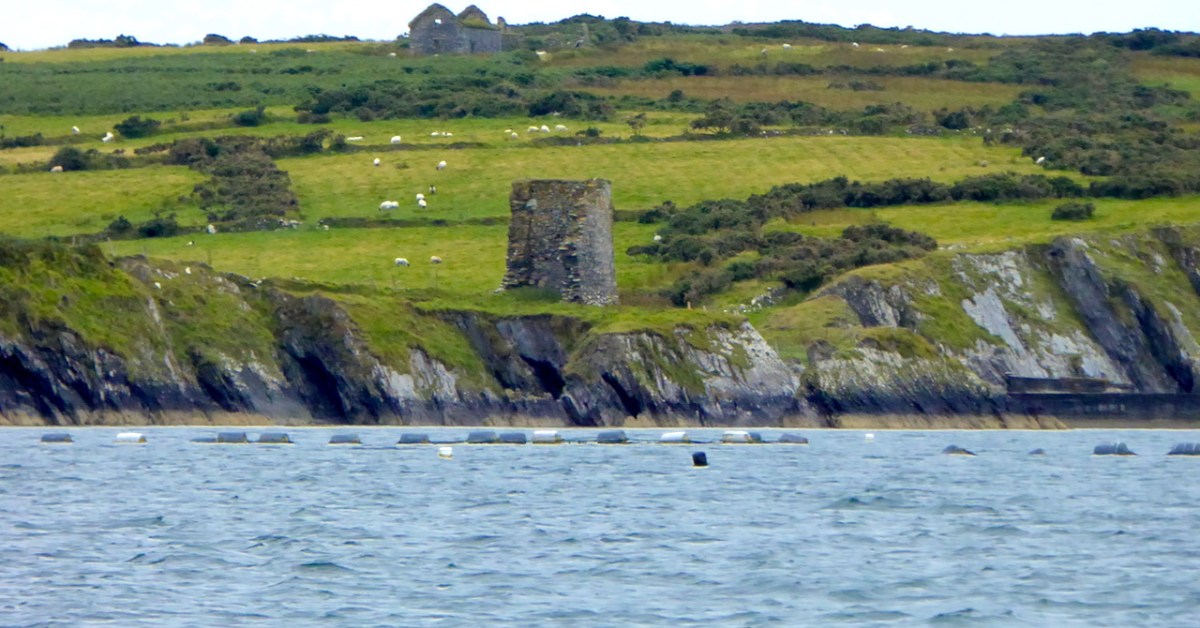
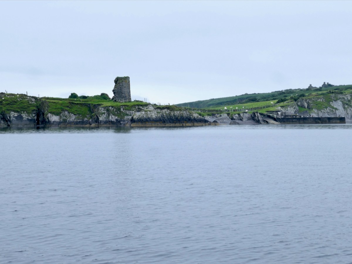
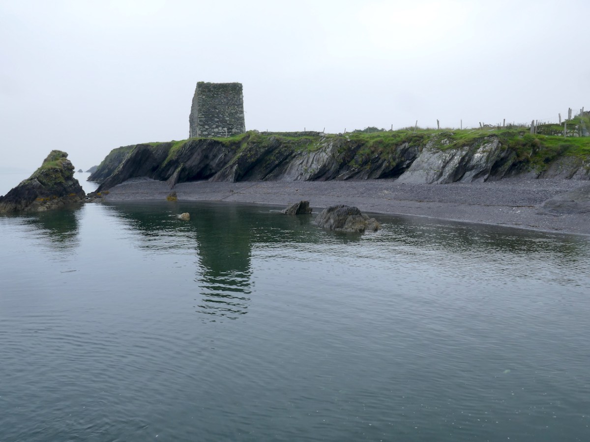
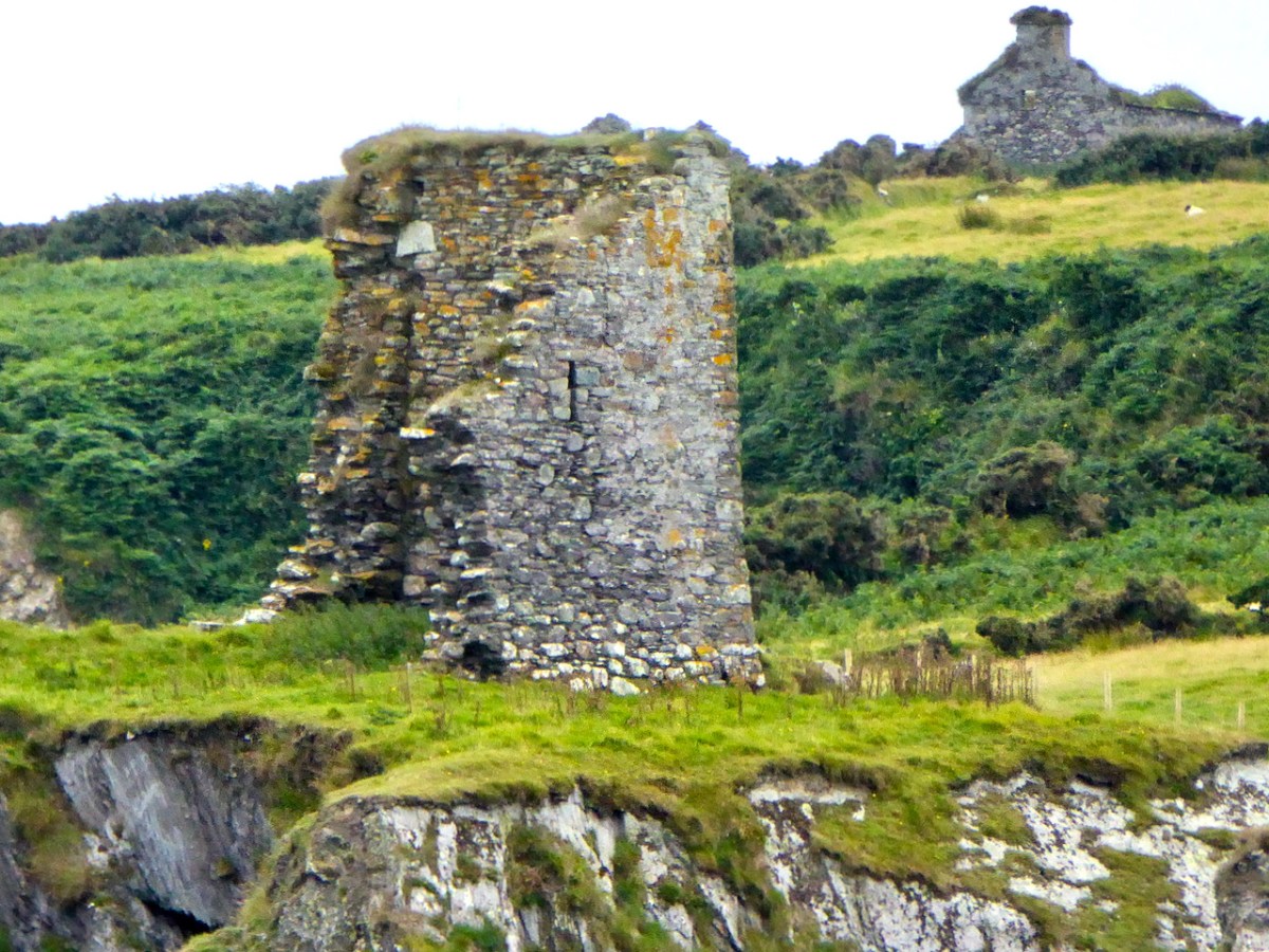
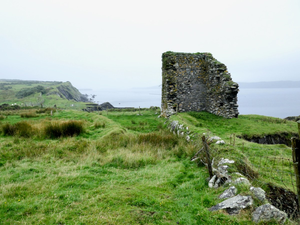
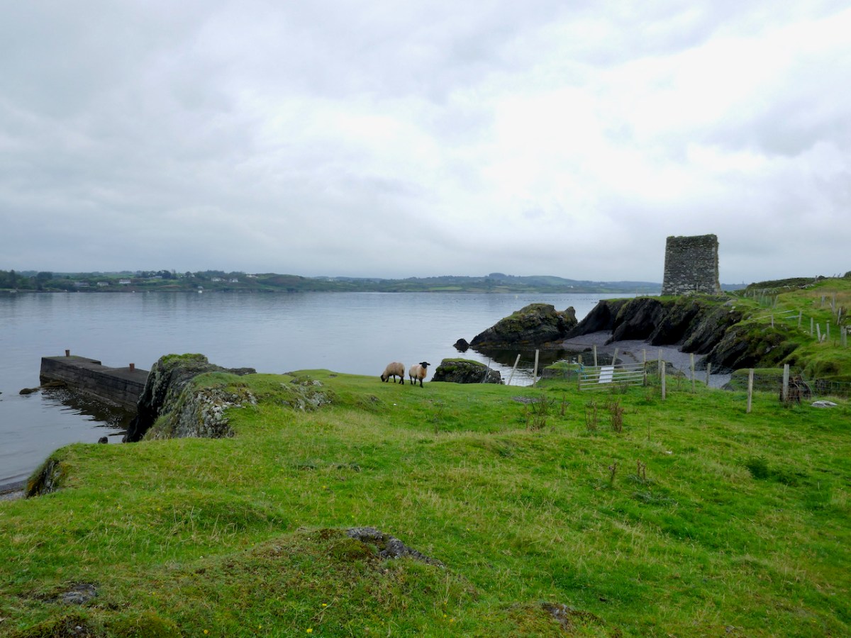
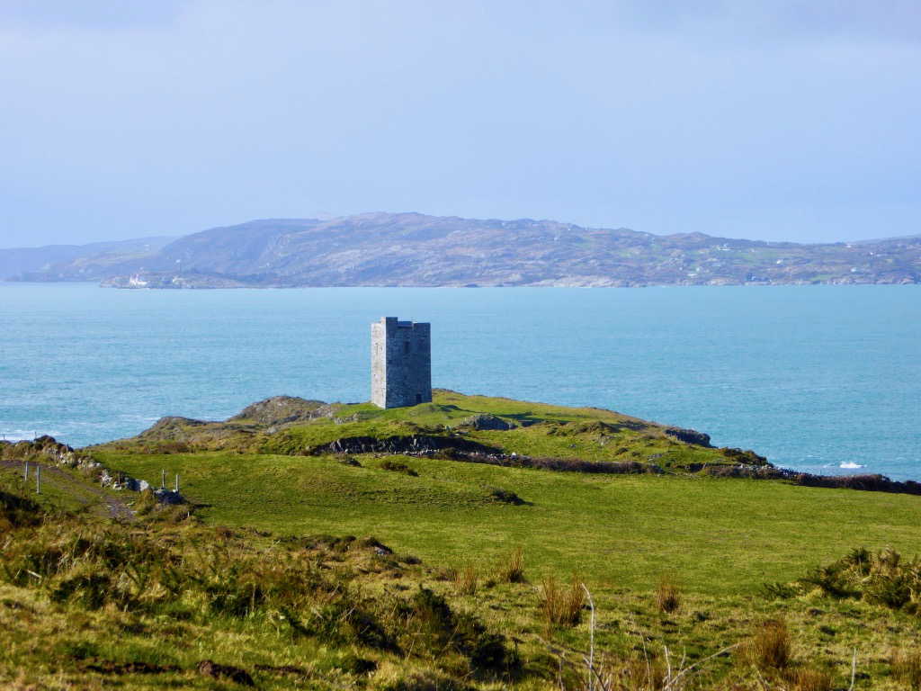
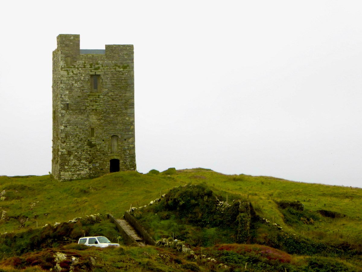
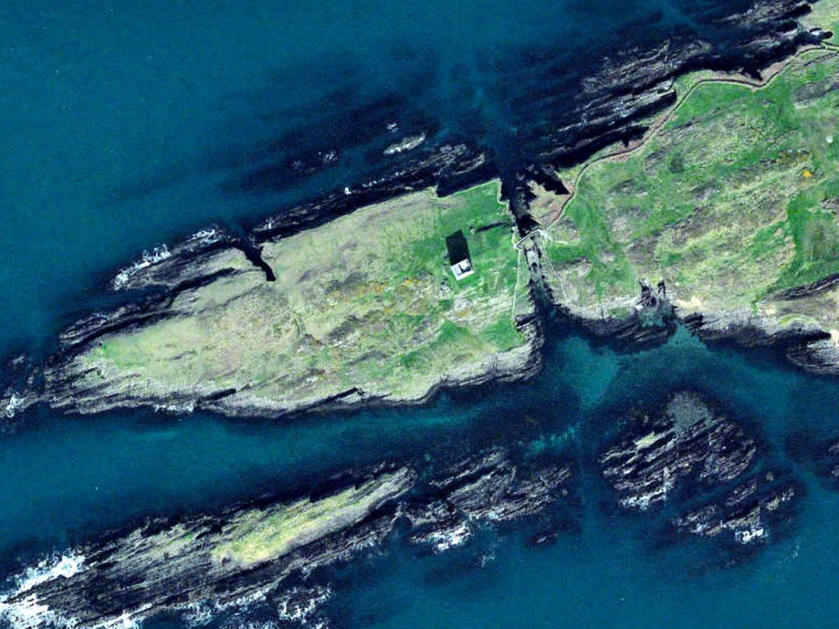
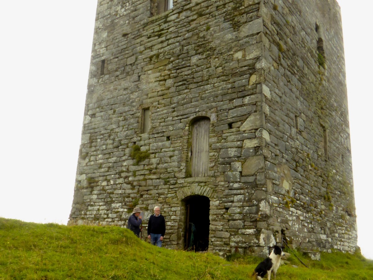
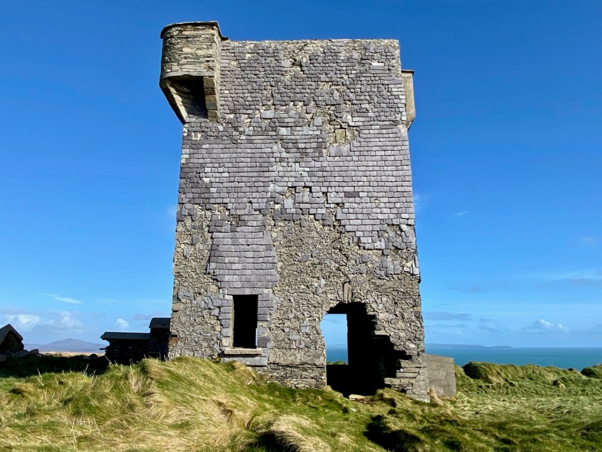
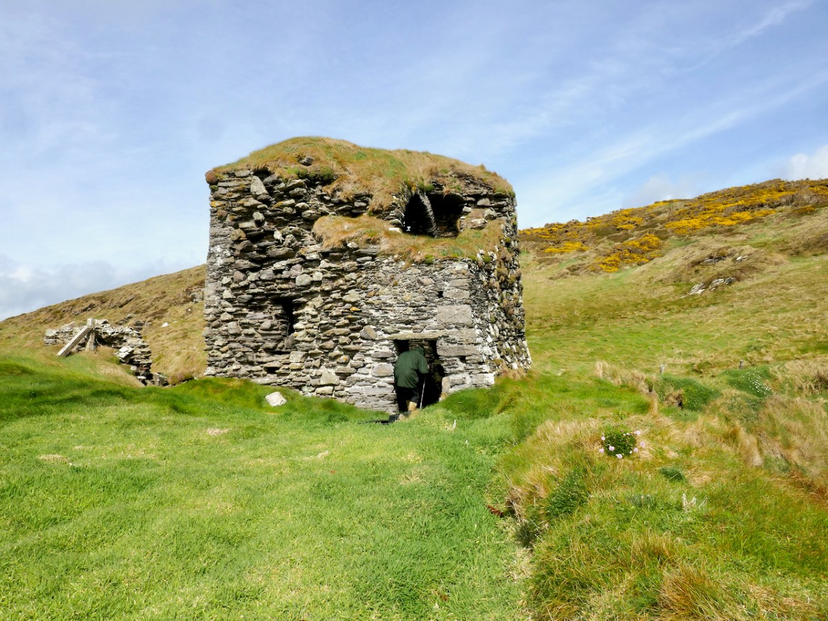
In the light of all this, let’s take a look at Dunworley. It’s unusual, in that the narrow neck of the promontory has had an additional feature built on it, in the shape of a small tower house – a gate house, in fact. 

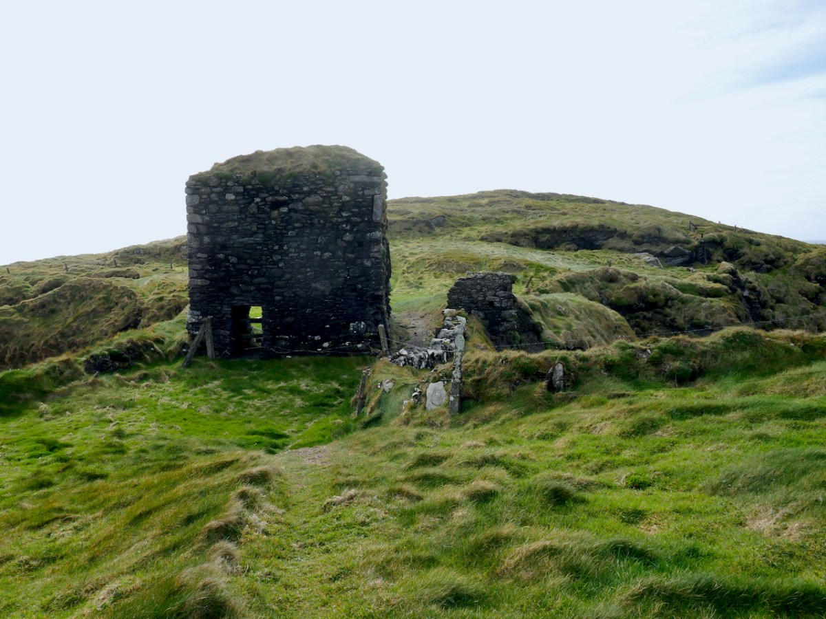
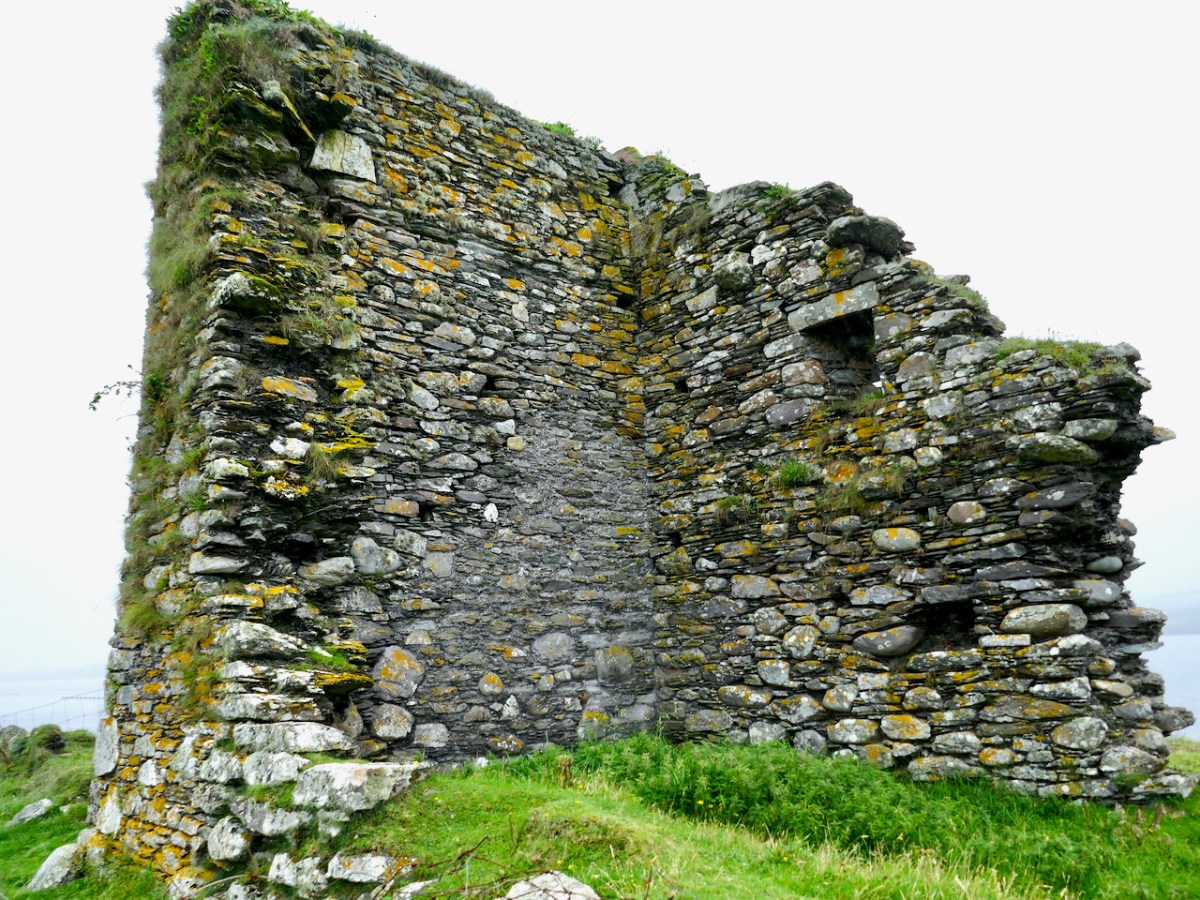
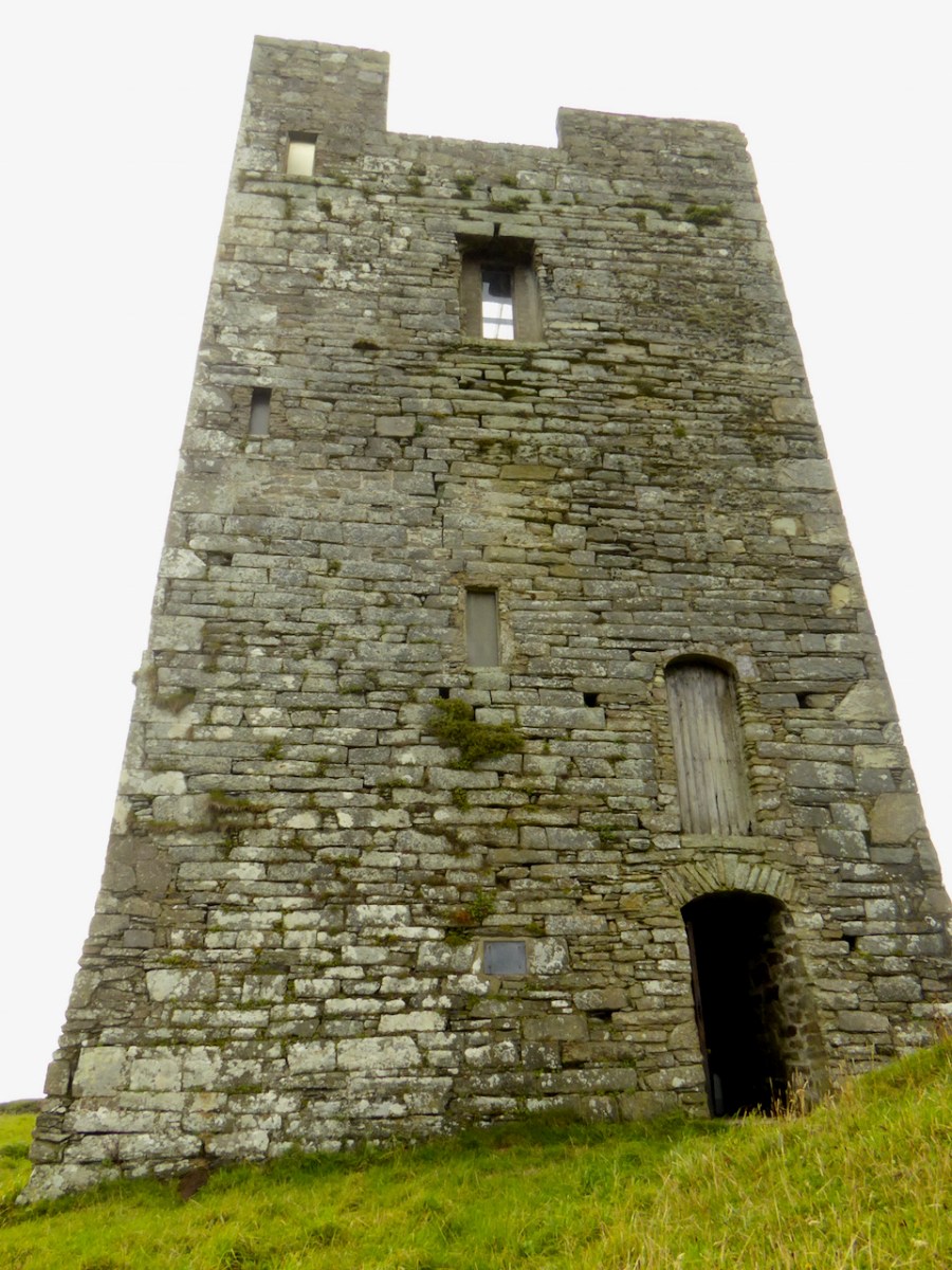
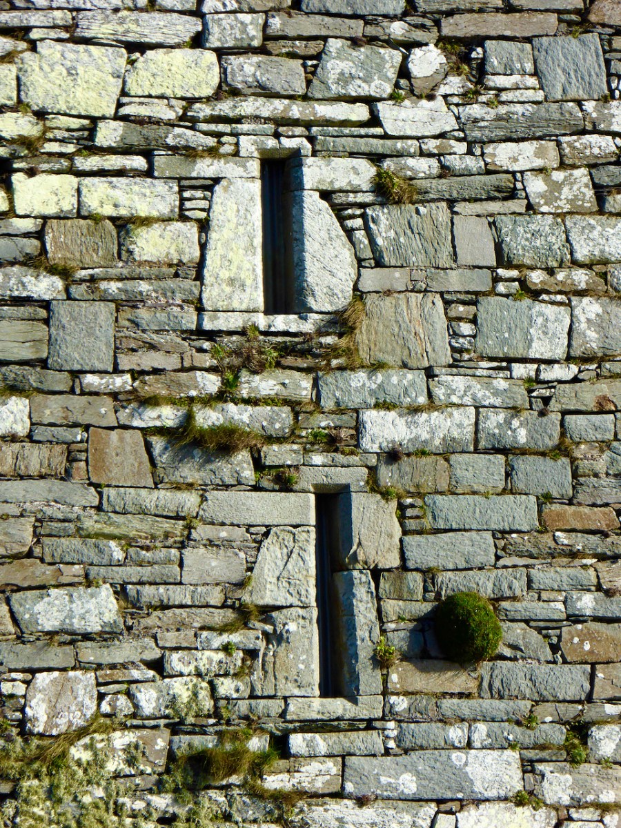
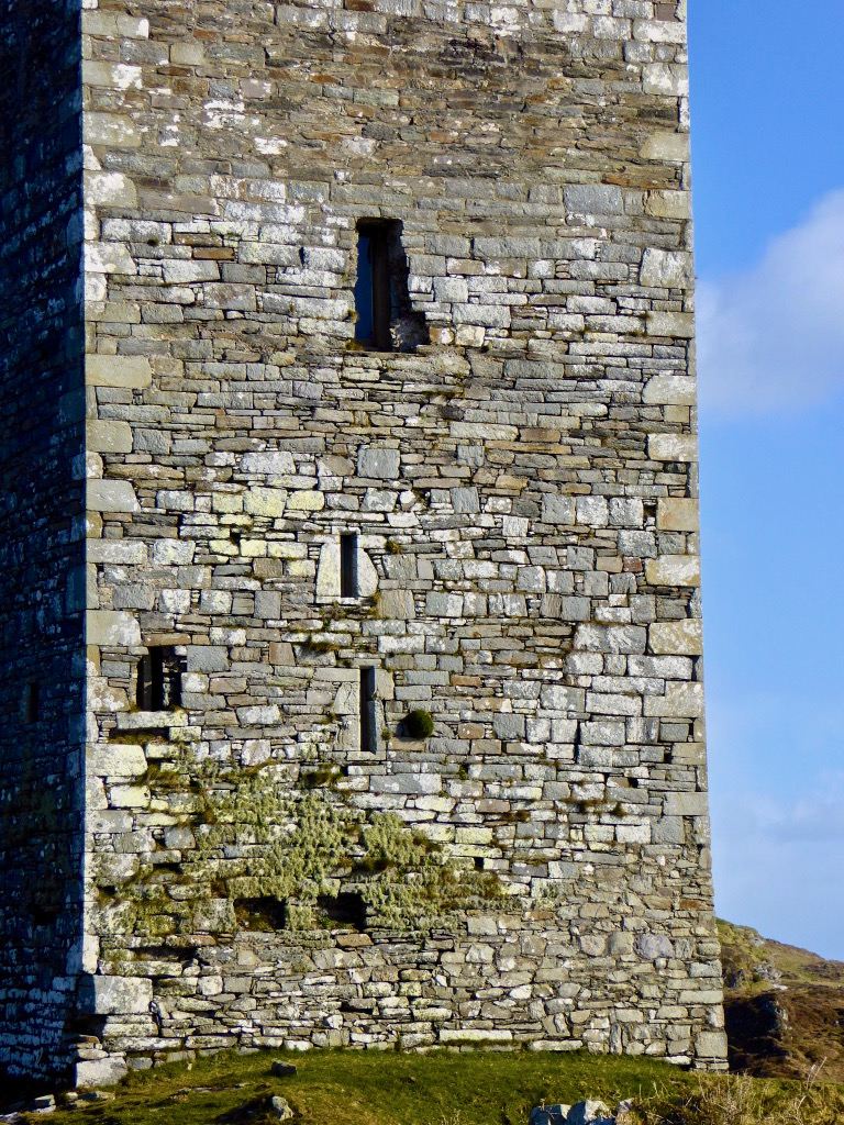
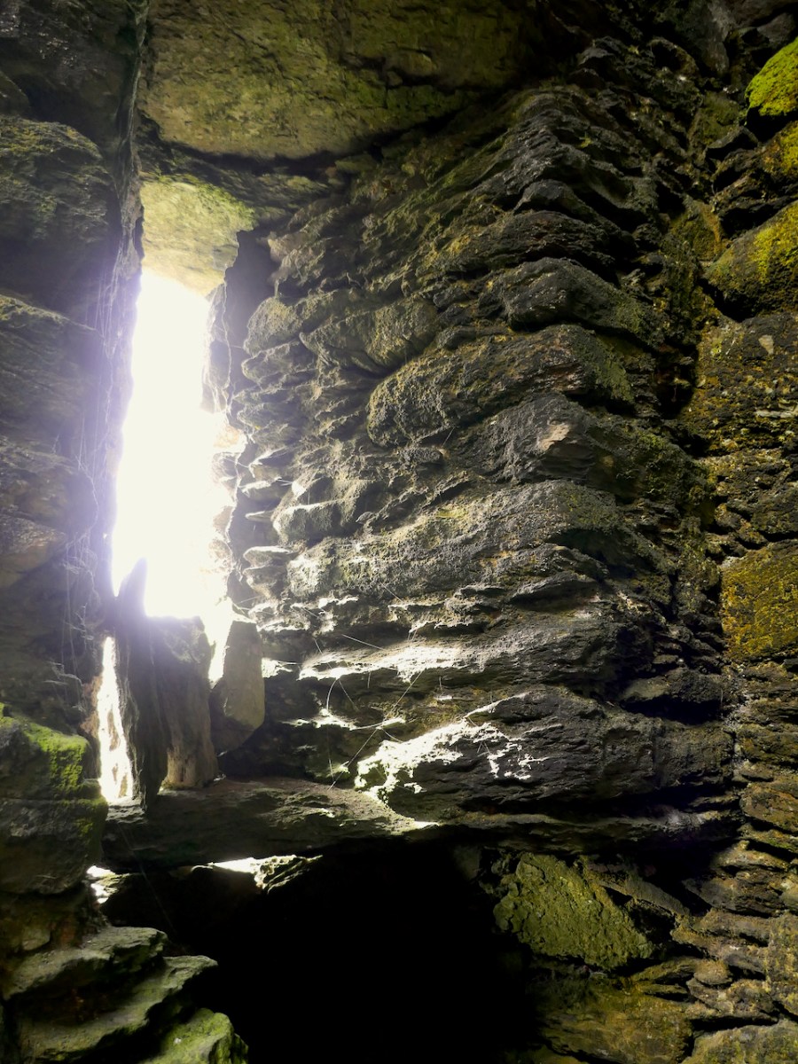
The features of this small tower (our guides called it a wee castle) are pretty typical of fifteenth century tower houses in West Cork (except on a smaller scale), with a base batter (lowest level splayed outwards), rubble construction, and inside one ope with a splayed embrasure (below). The two doors, back and front, are simple affairs and there is no sign of bar holes, eye or spud stones for the doors.

One of the more curious features, noted by Westropp, is that there appears to have been two floors, as evidenced by the corbels upon which the floor joists would have rested (below). However, the corbels are less than a metre apart, so it is hard to imagine how that space would have been used. 

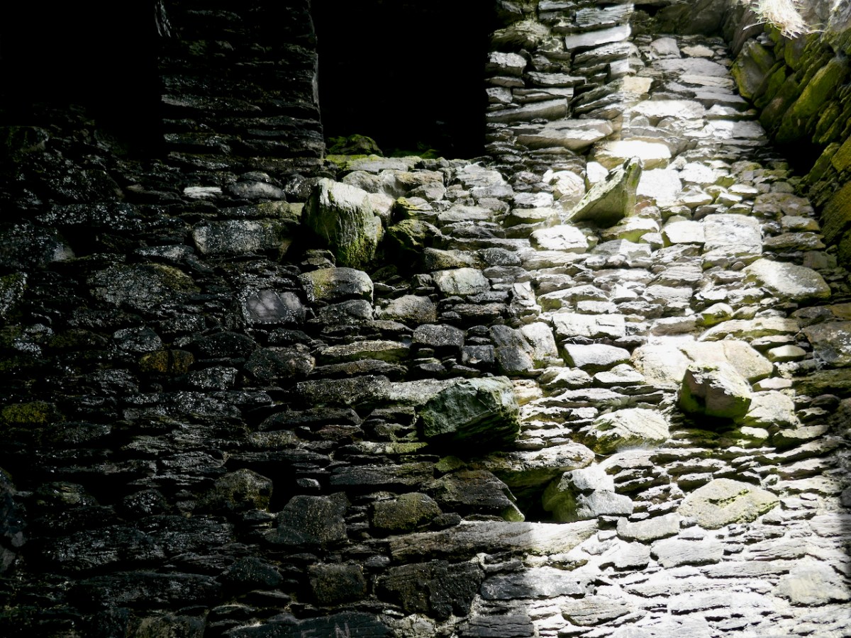
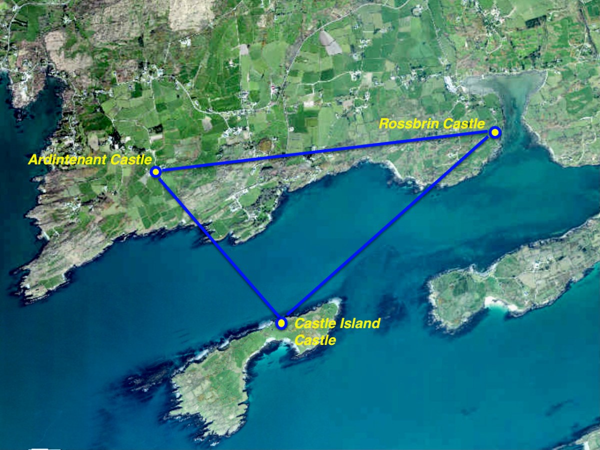
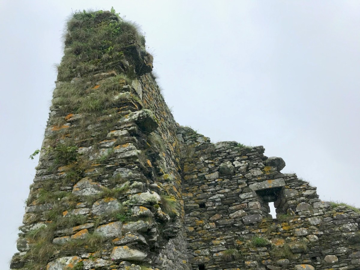
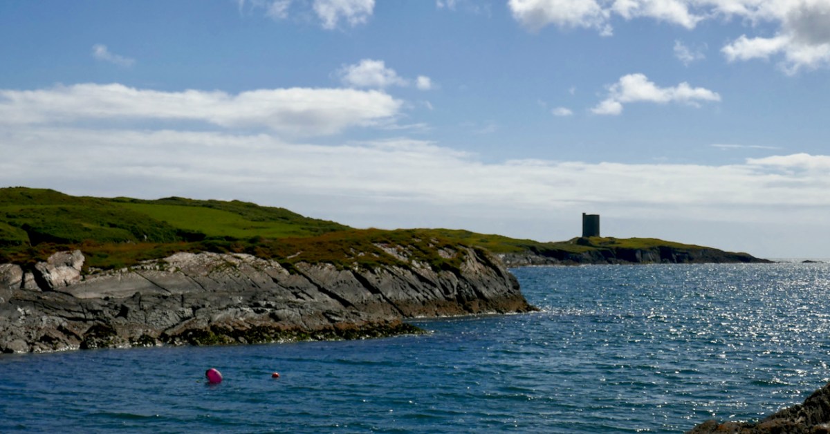
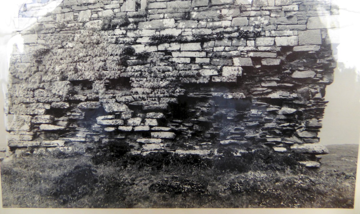
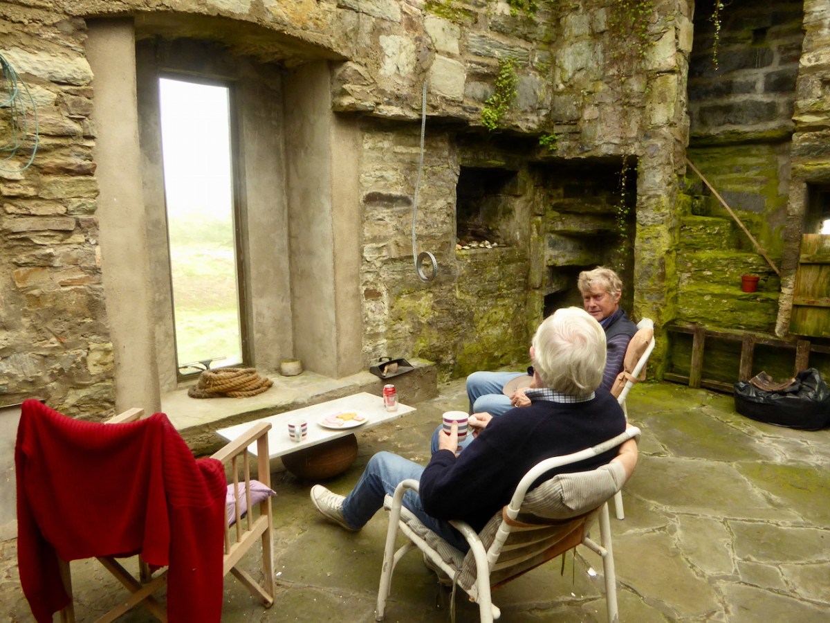
The internal vault, which would have separated the lower floors from the topmost floor and the wallwalk, is not a continuous vault but two arches which are covered by large slatey slabs. Although not as common as the continuous vault (see Dunmanus for an example of this), I have seen this type of vaulting in other West Cork towers – at Dunlough, for example, and less obviously at Dun an Óir on Cape Clear and at Rossbrin – all 15th century tower houses of the West Cork Irish families of O’Mahony and O’Driscoll.

Westropp, in his 1916 paper Fortified Headlands and Castles on the South Coast of Munster. Part I. From Sherkin to Youghal, Co. Cork, gives a complicated genealogy for the fort. He says it was destroyed by Fineen McCarthy after the Battle of Callan in 1260 – and this would imply that whatever original fortification was here, it was built by an Anglo-Norman family, since it was the anglo-Norman castles that Fineen destroyed. It may then have been taken over by the O’Cowhigs, but was definitely held by a branch of the Barrys by 1573. It passed to the Travers, the Hamiltons and back to the Travers. Jim Moloney, the present owner, told me that it has been in his family since his grandfather bought it.

Westropp, in his usual thorough fashion, provides a drawing of the small tower, both its position at the neck of the promontory, and a plan of the building itself – the top left and top centre plans below.

Some accounts mention a house on the promontory, but Westropp saw no sign of one. He did, however, note:

The day of my visit the headland was covered with cattle ; and it was interesting to see them, when called out to water, going in single file, without delay or hustling, through the little doorways, the outer 3 feet 1 inch wide, by 5 feet high ; the inner 2 feet 10 inches wide, and 5 feet 9 inches high. This shows how easily cattle might be brought through the small doors (but usually wider and higher than this gateway) in the dry-stone ring-forts.

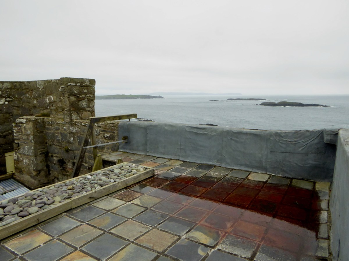
This is particularly interesting because the land is considered unsuitable for livestock now, because of the difficulty of getting them on and off the promontory and because there is no source of water on it. In any case, it has been declared an Area of Special Conservation, since the cliffs are home to nesting choughs – a very suitable designation for such an epic place.

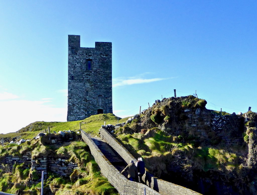
The day of our visit was a stormy one – Amanda was actually blown off her feet at one point. It was easy to see how such a place could be defended in times of attack, and act as a refuge. The whole area had such a wild, remote and romantic air that we truly felt privileged to be able to visit it, and to step back in time to imagine it in its heyday.

You can see us below, bracing against the wind. Many thanks to Diarmuid, Tim and Jim for facilitating our visit and answering all our questions. 

The Castles of Ivaha: ‘Fragmentary Remains’

What can you say about a castle where only fragments remain of the original structure? Turns out – a surprising amount!

Fragmentary remains is the phrase used in the National Monuments record to describe the two castles which are the subject of this post – Dunbeacon and Castle Island. In each case only enough is still standing to confirm that it was indeed a medieval tower house. Fortunately, in the case of Dunbeacon, there is also historical evidence. 

Let’s look at Castle Island first, and begin with the name. Samuel, in his thesis on The Tower Houses of West Cork, tells us that it was known locally as Castleduff, or Caisleán Dubh, the Black Castle. However, this was the name more commonly applied to Black Castle/Leamcon, so he says there might be some confusion there. There is no other name in the historical records – no mention, indeed, at all. Perhaps it was too insignificant to merit a mention – a fortified outpost rather than the high-status residence of one of the ruling O’Mahonys. 

We have noted with other of the O’Mahony castles that they were built on the site of a ring fort (Ardintenant) or a promontory fort (Dunlough). The National Monuments records notes a promontory fort at this site, although it is not obvious on the ground any more. There are, in fact several promontory forts noted on Castle Island, perhaps indicating that this was the preferred type of fortified dwelling here, since there are no ringforts.

Like all the O’Mahony castles, it was strategically sited – it was beside the waters that separates the island from the mainland, and within sight of two other castles – Rossbrin and Ardintenant. The three form a triangle that overlooked and guarded the sheltered waters of Castle Island Channel. But also, from the top of the castle, there would have been a clear view south across the low land in the centre of the island, out to Roaringwater Bay.

We know that these waters would have been crowded with Spanish, French, Portuguese and British fishing boats, coming in to salt their catches in the fish palaces along the coast and to replenish their supplies. For all of these services and for permission to fish around Roaringwater Bay they paid hefty fees to the O’Mahonys, who got fabulously wealthy as a result. 

The castle was much smaller than all the others. Samuel says, 

Working on the assumption that Castleduff was an RE tower house [i.e Raised entry], its smallness is striking. The surviving ‘end wall’ makes possible a reasonably accurate estimate of the plan’s original length. It is assumed that like its neighbours, its plan had a length-to-breadth ratio of 3:4 to 4:5; the ratios suggest a length of 7.96-7.46m (measures above the base-batter). The surviving north wall probably represents the full length of the ground-floor chamber.

Mark Wycliffe Samuel
the tower houses of west cork

The only surviving opening is a loop in one wall, and a row of corbels that would have supported the first floor is still visible. There is no trace of anything that might suggest a vault, so it is possible that this small tower was unvaulted – Samuel thinks that the walls are noticeably thinner than the other castles, implying that this was a much simpler and shorter tower.

Samuels concludes his study of this tower by saying:

The jetty is modern, but the beach that it is laid upon was the best natural landing point on the island, well sheltered from the Atlantic swell. The landing clearly determined the siting of the tower house and was an important resource to the family that built the tower house. It is tempting to see a direct continuity between the recent settlement and a settlement around the tower house. Only excavation could determine if this was the case.

Mark Wycliffe Samuel
the tower houses of west cork

Dunbeacon (images below) is even more vestigial than Castle Island, but fortunately we do have some historical evidence for it. The name could mean Fort of Beacan – where Beacan is the name of a chieftain. However, it could also mean The Fort of the Mushrooms – since the Irish word for mushroom is beacán. I like to think of the chieftain and his lady chowing down on a plate of eggs and mushrooms for breakfast.

As with Castle Island, there are signs that the castle was built within a former promontory fort, also underscored with the name Dún, which means fortress. A fosse, or ditch, cut through the rock, is all that remains of the fortifications of that promontory fort.

The majority of the O’Mahony tower houses in Ivagha were built by or for the sons of Conchobar Cabach. Dunbeacon castle was allegedly built by his brother Dohmnall. This seems to be a traditional rather than documented attribution. If it is assumed that Dohmnall was born c. 1400, he may have built the tower house at any date during his adult life (c.1420 to c.1470).

Mark Wycliffe Samuel
the tower houses of west cork

The siting is magnificent. From it, there is a clear view of the whole of Dunmanus Bay, right to the end of the Ivaha (Mizen) and Sheep’s Head Peninsulas. This, of course, also meant that it bore the responsibility, along with Dunmanus, of defending O’Mahony territory from attack or incursion on the north side of Ivaha. The pro-English Owen O’Sullivan of Beara, for example, is known to have conducted cattle raids on the lands surrounding Dunbeacon.

Samuel tells us that the chief of Dunbeacon, Domhnall O’Mahony, forfeited his lands as a result of his participation in the Desmond Rebellion, and it became a ruin – beautifully captured in Brian Lalor’s sketch, above.

The tower house and four ploughlands were confiscated, and passed into the possession of an English settler who probably built a timber house to the east. The O’Mahonys did not attempt to reconquer the lost part of their pobol; instead they contented themselves with attacking and burning the tower house, an event recorded in a letter written by an English judge in 1588. The tower house probably remained a ruin.

Mark Wycliffe Samuel
the tower houses of west cork

The O’Mahonys regained possession of their Dunbeacon lands but lost them again when they were granted to an English settler. See my post Planning a Plantation: Jobson’s 1589 Map of Munster Part 1 and Part 2 for how the land was mapped preparatory to the Plantation of Munster. As you can see above, Dunbeacon (or Donbeken) was clearly marked out for colonisation. William Hull came to own it at one point, and even the conniving ‘lawyer’ Walter Coppinger laid claim to it – as he did with much of the O’Mahony and O’Driscoll territory.

Although so little remains, Samuel’s careful analysis indicates that Dunbeacon was probably a typical raised entry tower house, with a vault supporting the third floor which held the principle private chamber. See my posts on Ardintenant  and Black Castle for what it may have looked like.

It’s hard to look at ‘fragmentary remains’ and think of them as vibrant centres of life. Yet, these two castles were once part of the mighty O’Mahony federation – a large network of connected families that ruled Ivaha and the surrounding seas. Sic Transit Gloria Mundi

Black Castle, or Leamcon

This is the fourth castle in my series The Castles of Ivaha, and the final one which is intact enough to be able to describe in detail (although I may have more to say about those which are more vestigial). Not just intact, though – Black Castle has been superbly stabilised and saved for future generations by its owner, Niall Hyde. 

Niall, by the way, thinks the the term Black Castle is more historically accurate. He points out that there is, in fact, in the townland of Leamcon, about 2km to the northeast, another ‘turret’ marked on the old OS maps, which is the remains of a castle built by the notorious Sir William Hull. Black Castle is in the townland of Castlepoint, and its name neatly distinguishes it from White Castle, AKA Ardintenant. Both were built by the O’Mahonys.

James Healy’s drawing of Black Castle from his wonderful book The Castles of County Cork, Mercier Press, 1988

As I said in my post on Ardintenant Conor Cabaicc succeeded his father in 1427 and remained Taoiseach for 46 years, embarking on an ambitious program of construction to provide castles for his sons and brothers. This included Black Castle, which he built for his second son, Finín Caol (pronounced Fineen Kale), or Finín the Slender. This means that Black Castle was built in the period before Conor Cabaicc (Conor the Talkative) died, in 1473. This accords well with its architectural details, which place it among the fifteenth century ‘raised entry’ castles, similar to Ardintenant, Dunmanus and Dunlough

The best source material for all the castles of Ivaha is the thesis The Tower Houses of West Cork by Mark Samuel. Here’s what Samuel says about the location of Black Castle, which he refers to throughout as Leamcon. Leamcon, by the way, means Hound’s Leap, which Samuel suggests may refer to a legend about the gully across which you must pass to get to the castle.

The western part of the Ivagha peninsula, the territory of O’Mahony Fionn, is now sparsely populated. Away from the formidable Mizen Head, the ice-sculpted land meets the sea with low, rocky cliffs. In this part of the Survey region, the strike of the rock is almost south-west/northeast, the layers being tipped close to the vertical, the shore tends to be sculpted into long peninsulas and islands running along the strike. Exposed to the Atlantic, it is a wild treeless shore. The fields once densely fanned prior to the famine, are now mostly given over to pasture. The tower house stands far from any road at the west end of a long narrow peninsula. Erosion has nearly severed the tip of the peninsula; only a precarious natural bridge, now reinforced with concrete, joins it to the mainland. The island is large, the ruins cover only a small fraction of its area. The tower house stands towards the island’s east end at its highest point. The promontory is for the most part gentle in relief, being covered by grass-grown ‘drift’ deposits.

THE TOWER HOUSES OF WEST CORK
MARK WYCLIFFE SAMUEL, 1998

When Niall bought the property the bridge consisted of a few planks. It must have been a hairy business getting across to it until he built the concrete walkway you see today. Niall and his family spent their summers at the castle – can you imagine, as a child, what it must have been like to have your own castle to play and live in? Magical! Although I do think about what it must have been like for Dorothy, who spent the weeks there with the children while Niall worked in Dublin. How did she manage to feed them and keep them safe? A heroine, indeed.

Like the others I have described in detail, Leamcon is a raised entry castle. To recap – the ground floor entry gave access to the ground floor, and possibly by means of a ladder to the second floor and mezzanine. The raised entry gave access to the second floor, and then, by means of a strait mural staircase, the the floors above the vault. Take a look at the cut-away diagram in Illustrating the Tower House: A Guest Blog to see what I am talking about here. Thus, the upper floors could only be accessed by one staircase, a defence feature, and being above the vault provided security from fire in the lower floors. Given that there were no fireplaces, and that braziers were lit in the middle of the floor, with smoke escaping however it could, this was probably a good idea.

Another defensive feature was the small opes, or windows, through which no attacker could climb and little light could penetrate

As regards defence, the castle was attacked by Carew’s forces after the Siege of Dunboy in 1602. According to Samuel:

Sir George Carew reported, on 13th July 1602, that his lieutenant, Captain Roger Harvy, had taken several castles strongly seated on rocks and necks of land. All were so ‘neere unto the sea where ships may safely ride, and fit places for an enemy to hold as, namely Leamcon, Donnegall’ and others. The decision was taken to burn these tower houses. Conor, the head of the sept, received quarter with his men and migrated to Spain immediately afterwards. He was subsequently pardoned but seems never to have returned.

THE TOWER HOUSES OF WEST CORK
MARK WYCLIFFE SAMUEL, 1998

Black Castle wasn’t burned and it subsequently was reclaimed for a time by the O’Mahonys, although the clan forfeited all or most of their lands after the rebellions of the 1640s, and the castle was abandoned from at least the 1690s. Such was the state of it when the O’Mahony Reunion took place here in 65 or 66.

All those years of neglect had resulted in a castle in a perilous state of dereliction and Niall and his builders set about stabilising it before they could make it habitable. The base batter – the broad foundation that give the walls a strong base – had first to be repaired. This called for great skill and the results are impressive. Niall has left a band of membrane to indicate where the old and new stone work meets.

The castle was built to align with the strike of the rock, a feature of most of the Ivaha tower houses. The strike is the compass direction in which the rock bed is running and for West Cork that is mainly in a northeast to south west direction. The builders chose a prominent and solid rocky platform, still easily discernible, and probably prepared it by digging away any soil and loose rock and may have laid down a layer of mortar to help bind the lowest slabs to the rock surface. 

At Black Castle, the quality of the masonry varies, leading me to think that not all stone masons were as skilled, or perhaps as careful, as others. See the variation in the image below. The quoins (corner stones) were made of fine-grained sandstone that can be freely dressed in any direction (called Freestone), while the stones used to dress the outer layer were carefully chosen (or deliberately shaped) to be smooth and even, lending a pleasingly sheer surface to the castle exterior, sometimes called  an “ashlar finish.”

The raised entry, in the case of Black Castle, is directly about the ground-level entry, similar to Ardintenant, but unlike Dunmanus where the entries are staggered. The entrance to the upper door would have been by means of a wooden staircase, possible from the small rocky knoll across from the entrance.

In his conversion of the castle to provide habitable space, Niall concentrated on the upper floors. There is a living room, kitchen dining area and bedrooms, along with a toilet and shower which are situated in the original garderobe space. 

By roofing and waterproofing the building, Niall has kept further deterioration at bay. It is a joyous thing to sit and look over the countryside with a cup of tea on hand, or to climb up to the wall walk and gaze over the wild and rugged peninsula, imagining Carew’s forces advancing across the sea.

Niall Hyde has managed, on a limited budget, to salvage Black Castle and indeed turn it into a space that his family enjoyed. We should all be grateful to him, and to others who have taken on such tasks with vision and courage. Without the Niall Hydes of this world, we would all be the poorer.

Robert’s Favourite Posts of 2021

It was another strange year: we had hopes that the pandemic would be conquered. We have had vaccines, boosters and mutations, but Covid still dominated all the headlines and affected our lives. (Finola’s selection is here.) We coped with lockdowns and restrictions, but took full advantage of the times when we could travel freely. One of the most memorable expeditions brought us to Kerry, where we looked at early Christian sites but also took in a lot more:

Earlier in the year I went back to my childhood days, remembering when I first learned about Jonathan Swift from my Granma, and walked with her to the places associated with him in the town of my birth: Farnham, Surrey. Here is the post.

If you read my ‘Dean Swift and I’ post you will find this engraving of ‘Mother Ludlam’s Cave’ which was close to Stella’s Cottage, and must have been familiar to Jonathan Swift during his years living in Surrey. I came across this old print in a local bookshop when I was growing up in Farnham, and it has stayed with me ever since

I have been keeping a few series of posts going through the year: one is about the Napoleonic signal towers that dot the coastline all around this island. I began the series in 2020 (do you remember how we thought the Covid restrictions would soon be over?). In 2021 I continued the posts with new episodes. This is one of my favourites.

The Napoleonic Signal Tower at Brow Head, West Cork

Another series explored the Ilen River, West Cork’s most significant waterway. We still haven’t been to its source – said to be on the summit of Mullaghmesha, north of Castle Donovan – but this post (Ilen’s End) took us to the point at which the river meets the Atlantic.

West Cork had good coverage from our blog during the year which has just ended. I began a series of posts about West Cork Villages and Towns. Perhaps it was an interesting time to concentrate on our local communities: hopefully it proved that we West Corkonians are not deterred from celebrating life as much as is possible in these strange times.

The communities of (top to bottom) Bantry, Schull and Skibbereen have been the subjects of posts in my West Cork Villages and Towns series in the past year. There are many more to come in the future, including the remarkable activities that take place in our ‘home’ village, Ballydehob (below).

All but a year ago I put my tongue firmly in my cheek and imagined an encounter between my ancestor Robáird an Tuairisceoir Fáin and  the Scholar Prince of Rossbrin – Finghinn O Mathuna – who was Tánaiste of the great West Cork O’Mahony clan, and who lived down below us in Rossbrin Castle in the fifteenth century.

It proved a remarkably popular post and I was forced to admit that it did come from my imagination, although all the background historical information can be verified. What really interested me was the interest and enthusiasm that everyone has about life here on our wild West Cork coastline all those centuries ago!

We are most fortunate to live overlooking Rossbrin Cove and the islands of Roaringwater Bay

It’s always a difficult task to choose just a few posts from the 50 or so each of us has written over the last twelve months. If I started all over again I would probably choose many different ones. But they are all still there to be read (dating back to 2012): you only have to search the archives! Our new year began – yesterday – with the enactment of an ancient Irish tradition in Ballydehob: the Wran Day. That will be my post next weekend, but here’s a taster. Happy New Year everybody…!

Planning a Plantation: Jobson’s 1589 Map of Munster Part 2

As I said in Part 1, this map was made to provide information for the purposes of plantation – that is, colonisation – of Munster, and in particular of those lands forfeited by the Desmonds after their ill-fated rebellions. Jobson, the cartographer who signed this was, according to Andrews, an enthusiastic map-maker who was unusually determined that his maps would survive. Accordingly, he made copies and presented them to likely future employers – hence this one, inscribed to Lord Burleigh, faithful and long-serving eminence grise to Elizabeth 1. That’s herself, below. (Full citation for the map is at the end of the post.)

Andrews says of Jobson:

He also showed unusual zeal in presenting duplicates to likely patrons: no one was going to deprive posterity of a Jobson map by “borrowing” the only copy. Other features of his complex cartographic persona were more distinctly Irish, such as his deceptively slapdash-looking style and his apparent ignorance of earlier Anglo-Irish cartography.

Colonial Cartography in a European Setting:The Case of Tudor Ireland
J. H. Andrews

Much of the ‘slapdash’ nature of the map can be explained when we realise that this map, in fact, was a reduction to small scale of detailed townlands surveys that he, Jobson, and others had carried out, and that he obviously had not been able to make all his observations ‘on the ground’ for whatever reasons. The map was studied in the late nineteenth century, along with a host of other evidence by W H Hardinge. He starts his paper, read to the Royal Irish Academy in 1891, by giving the background to the maps: 

So soon, however, as the Queen and her Council decided upon establishing, under certain conditions and limitations, a plantation of her English subjects upon these forfeited territories; and for that purpose determined to grant them out to undertakers, in scopes of twelve, ten, eight thousand, and a lesser number of English acres, it became indispensable to the interests of the crown, as well as to equity in the distribution of the lands amongst the undertakers, to have the area of each town accurately measured, ascertained, and laid down upon a plot or map. Accordingly, I find a commission to that end, bearing date the 19th June, in the twenty-sixth year of the reign of Queen Elizabeth [1584], accompanied by minute instructions from the ministers and lords of Her Majesty’s Privy Council in England addressed to Sir Henry Wallop, Knt., under-treasurer of Ireland, and to other commissioners there, of whom the auditor-general, and the surveyor and escheator-general were two; authorizing and requiring them to make special inquiry in relation to said forfeitures, to measure the demesnes, and to reduce acres to plow lands, according to the custom of the country, and to value the acres rateably according to perches. The survey was completed in the year 1586, and must have been returned into England, as ” The Plot from England for inhabiting and peopling Munster” was soon afterwards sent to the lord deputy. And, further, a very large proportion of the principal plantation grants were passed under the great seal of England almost simultaneously, based upon that survey, and which could not have been so passed unless the guiding information enabling the distribution had been on the spot.


On Mapped Surveys of Ireland Author(s): W. H. Hardinge and Ths. Ridgeway
Proceedings of the Royal Irish Academy (1836-1869) , 1861 – 1864, Vol. 8 (1861 – 1864), pp. 39-55 Available here

Hardinge then goes on to comment on Jobson’s Map of Munster:

In a long and expressive marginal note, Jobson sets out his services, stating “that he was three years in her majesty’s service, surveying and measuring part of the lands escheated to the crown in Munster ;” and further, “that Arthur Robinson and Lawson were employed on same survey.” The map in question is genuine, and clearly a reduction by Jobson from the townland surveys, made in pursuance of the pre-recited commission, as a gift likely to be acceptable to Lord Burleigh. 

From such accumulated evidence, I concluded that there must have been mapped surveys accompanying the inquisitions and books of survey; and that nothing less could satisfy the exigencies of the plantation – a work that was to be guided by a measure of land up to that time unknown in Ireland, and by a scale of crown rent imposition of three-pence per English arable acre. 

In a further note, he cites the cost of the survey as £2,900 – this translates to about £700,000 in today’s money.

This is the frontispiece to Saxton’s Atlas of the Countries of England and Wales. Christopher Saxton was one of the premier Elizabethan cartographers and in this glorious illustration he is showing how indispensable maps and map-makers are to Elizabeth and to the world. Source Wikimedia Commons

Munster in this map refers to the counties of Waterford, Cork, Kerry and Limerick, rather than the present-day province which also includes Tipperary and Clare. Let’s take a closer look now at some more elements of the map, starting with the section on the counties of Cork and Kerry. Two peninsulas (yes – only two!) are clearly delineated, surrounded by galleons. Note the two crests, one with a harp and the other with the English cross of St George, both bearing the regal motto of Honi Soit Qui Mal Y Pense.

Honing in to take a closer look at the green area (below) labelled the Counte (County) of Desmond we see that the principal families names are Macarte Moor (McCarthy Mór)), who were the overlords of West Cork, and O’Swellivan Bear (O’Sullivan Bear) on the south coast. Below is Donal Cam O’Sullivan Beare – the very man named on the map – read more about him in An Excursion to Dunboy.

Bere Island is Illan Moor (Illaun Mór, which is its traditional name – Large Island – as it is, in fact, Ireland’s largest island). Whiddy Island is called Illanfoyde, and is assigned to the O’Sullivans. All around Bantry is assigned to Rogers, a completely unfamiliar name, although one of our commentators last week noted that there is a strand there called Roger’s Strand!

That whole green area is odd, though, isn’t it? In fact, the Beara and Iveragh Peninsulas are shown as one large landmass, with the Beara marked off by an orange line. Here is the surest evidence we have that this map was not drawn on the ground (or by sea) using actual observations and measurements. The coasts and hinterland of both these peninsulas must have presented formidable obstacles to cartography and reminds us that mapping was a dangerous profession in Elizabethan Ireland.

The dangers are starkly revealed in an account by the Attorney General who related that Richard Bartlett, ablest of all the Queen’s Anglo-Irish cartographers, was beheaded in Donegal in 1609 “because they would not have their country discovered”.

And if it wasn’t the natives, then it was the arduous work of surveying these wild lands that challenged the map makers. This was highlighted by the story of Robert Lythe, an English military engineer who almost went blind and lame while serving in Ireland from 1567 to 1571.

how ireland was mapped By Rose Mitchell Map Specialist, The National Archives

Dingle (in red), however, is a different matter – it has assumed outsize proportions, probably an indication of its importance in the Desmond Rebellions. There are many more place names on it than there are on the green mass. Ventry and Smerwick Harbours are indicated since both were important sites of resistance in the Desmond Rebellions – the barbarous massacre of Spanish and Italian allies at Smerwick was one of the decisive acts in the war, and involved such luminaries on the British side as Black Tom Butler, Earl of Ormond (below), Walter Raleigh and Edmund Spenser. Ventry was where the English troops entered the peninsula.

The Bay of Tralee is noted and the area around it is labelled DENE – this refers to the lands granted to Sir Edward Denny (below). I have written about the extraordinary story of the Dennys and their tenure in Tralee – a story that culminated in Ireland’s Newest Stained Glass Window. And by the way – can you see Sliabh Luacra at the bottom of this section – the home of a distinctive tradition in Irish music.

Whew – better end there for today. As you can see. we have barely scratched the surface of what can be gleaned from this map. Perhaps we will revisit it in a future post – but for now I leave you with the tip of the Dingle Peninsula, slightly expanded from the lead image, so you can try your own hand at making out what an Elizabethan planter might have been vitally interested in.

I am grateful indeed to Michelle Agar, Cataloguer, Digital Collections, at the Library of Trinity College Dublin, who gave permission to feature the map from the Hardiman collection in this blog. Also to the kind office of Dr Áine Madden, Communications and Engagement Coordinator with the Digital Repository of Ireland at the Royal Irish Academy. The complete citation for the map is as follows: Jobson, Francis, & Manuscripts & Archives Research Library, Trinity College Dublin. (2021) The Province of Munster, Digital Repository of Ireland [Distributor], Trinity College Dublin, the University of Dublin [Depositing Institution], https://doi.org/10.7486/DRI.rb69b272p

Planning a Plantation: Jobson’s 1589 Map of Munster Part 1

The sixteenth century was a desperate time in Munster. Two successive Desmond Rebellions (read about them here and here) had resulted in a devastated countryside where, according to the Annals of the Four Masters the lowing of a cow, or the whistle of the ploughboy, could scarcely be heard from Dunquinn to Cashel in Munster. The power of the FitzGeralds, Lords of Desmond, and their allies among the Gaelic chieftains, had been broken.

The Tudor government determined that what was needed was a complete colonising effort, that would bring the benefits of English civilisation to the lawless Irish. William Cecil, Lord Burleigh, set about planning the Plantation of Munster. 

In June 1584, a commission surveyed southwest Munster, mapping out the lands belonging to a swathe of Irish lords associated with the rebellion, which were then granted to a small group of wealthy English Undertakers.

John Dorney: The Munster Plantation and the MacCarthys, 1583-1597
Jobson’s dedication – to the Right Honourable the Lord Burleigh, Lord High Treasurer of England

What a project like this needed, of course, was an accurate map and they were hard to come by in medieval Ireland. Francis Jobson, a free-lance cartographer, set himself the task of producing such a map, and in 1589 he inscribed this one, The Province of Munster Map (the subject of this post), to Cecil. The original is in the library of Trinity College and I have been given permission to use it in our blog (see end of post for complete citation.)

Jobson’s signature

George Carew, one of the primary planters, the first President of Munster, was a man who asserted he had an ancestral claim to large chunks of Munster. To back up his various claims, he collected papers and maps in support of the colonising efforts, and these maps later found their way to Trinity College in Dublin, to form part of a collection called the Hardiman Atlas, after the nineteenth century librarian who recognised what they were and bound them together.

The Province of Munster Map is but one of this collection, now digitised and available for viewing in the Digital Repository of Ireland. And an excellent job they have done of it – the high-resolution image is so clear that it allows us to zoom in and see lots of detail. Here is the complete map.

The first thing that strikes the modern viewer is that Ireland is on its back – that is, instead of north being at the top, west is. This wasn’t unusual for the time. JH Andrews, one of Ireland’s foremost cartographic historians explains it thus, With east at the bottom, Dublin, the Englishman’s point of entry to Ireland, is the point on the map nearest him. To provide a more normal orientation, I have turned the map sideways, below, so you can assess how accurate it is.

The task facing Jobson was to provide as clear information as possible for the colonising effort. Any kinds of fortifications, where the Irish could defend their territory, were important, as were transportation corridors, by sea, river or land, as well as barriers to movement, such as mountains or dense forests. Control of the fisheries had generated great wealth for the Irish chieftains so it was important to have details of coastal areas. 

Speaking of Jobson’s Map of Ulster, Annaleigh Margey says

His maps are crucial to our understanding of England’s changing relationship with Ulster at the end of the sixteenth century. As the Nine Years’ War began, Jobson provided representations of the Gaelic lordships in Ulster, but also imposed England’s vision for the creation of a new county system onto the provincial landscape. In Jobson’s 1598 map, now at Trinity College, Dublin (p. 42), this framing of the new political geography is obvious. Throughout Ulster, the various Gaelic lordships are denoted by the lord’s name and a line defining their boundary. Settlements such as castles and churches that could be integrated into English settlement plans are displayed by small replicas in red across the map.

Annaleigh Margey: Visualising the Plantation:mapping the changing face of Ulster
History Ireland, Issue 6 (Nov/Dec 2009), Volume 17

She could well have been speaking of the Map of Munster. The principal families and their territories are all presented, as well as their main castles. While West Cork is not rendered accurately, we can see what Jobson felt was important to include. The O’Mahonys (Mahound) are there and the castles shown for them are Dunbeacon, Rossbrin and Ardintenant, which is labelled C o mahoun, as befits the castle of the Chief (see my post on Ardintenant here). The whole of Ivaha (now the Mizen Peninsula) is assigned to Mohon (spelling was approximate in these maps) and Crookhaven is indicated, probably because it is an excellent harbour.

The O’Driscolls are shown at Baltymore, with Castles also on Sherkin (Ineseyrkan) and Cape Clere. The Ilen River is shown as the Ellyn ff (ff or flu is often found on old maps to designate a river). Interestingly, the whole of the Sheep’s Head has no detail on it and only one word – Rymers. The O’Dalys were the traditional bards of several Irish families and they had their bardic school near Kilcrohane – they are The Rymers! The Abbey in Bantry is noted (in fact it was a Franciscan Friary) – and even Priest’s Leap is on this map. Once the only land route between Bantry and Kenmare, it is now a steep, treacherous and extremely scenic back road.

We have only just started looking at this map. The next post will continue the journey. Meanwhile – have a look yourself and see what you can see. I have lots of questions about it – for example, about the scale that Jobson uses (above) – I am hoping our readers might have some answers!

I am grateful indeed to Michelle Agar, Cataloguer, Digital Collections, at the Library of Trinity College Dublin, who gave permission to feature the map from the Hardiman collection in this blog. Also to the kind office of Dr Áine Madden, Communications and Engagement Coordinator with the Digital Repository of Ireland at the Royal Irish Academy. The complete citation for the map is as follows: Jobson, Francis, & Manuscripts & Archives Research Library, Trinity College Dublin. (2021) The Province of Munster, Digital Repository of Ireland [Distributor], Trinity College Dublin, the University of Dublin [Depositing Institution], https://doi.org/10.7486/DRI.rb69b272p