A Map of the County of Cork, Part 3

This is the last part (links to Parts 1 and 2 at the end of the post) and I will use it to look at where most people seemed to be living – along the River Lee and the Blackwater/Bride Rivers. Cork is shown, as we know it was and still is, on an island, as a substantial walled town with four towers. Two of the towers guard bridges and are ports of entry, and two guard inlets of the river. There’s a cross in the middle and five buildings outside the walls. 

The buildings to the left of the city (remember, that’s North) are labelled Mogelle, F:barro and M:nellan, while to the right (south) the upper building is unlabelled and the lower one is C:Tanboy?

To see what this is all about, let’s take a look at the earliest map of Cork City, which I showed you in my post Mapping West Cork, Part 2: John Speed. I reproduce that map here. It dates from 1611/12. As I said in the John Speed post, while Speed seems to have based his land maps on earlier work by Mercator . . .

. . . the city maps were all new and it seems that Speed, with one of his sons, actually travelled to the cities he includes in his atlas and paced out the distances, drawing the maps based on these calculations. They are a unique and invaluable record of a time when Ireland had walled cities, especially given that so few intact stretches of those walls remain.

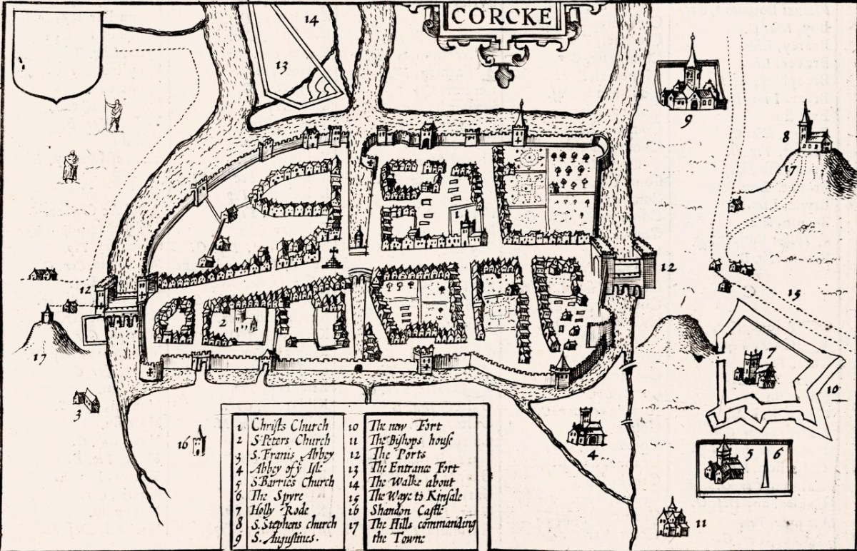
And there is the Market Cross! While that is the only feature inside the city on our map, Speed’s is beautifully detailed, and he provides a key to all important buildings. There are many churches, only two of which, Christ Church and St Francis’s Church, are within the walls. Assuming that Finbarr’s church is labelled F:barro on our Map (although the brown rectangle looks more like a tower house) and St Barrie’s Church on Speed’s, it is shown in different places. St Augustine’s or St Stephen’s may be the uppermost building to the right of the city, but what is the brown pyramid-shaped blob labelled C:Tanboy? Perhaps a true Cork historian can help us out here and figure out what’s what.

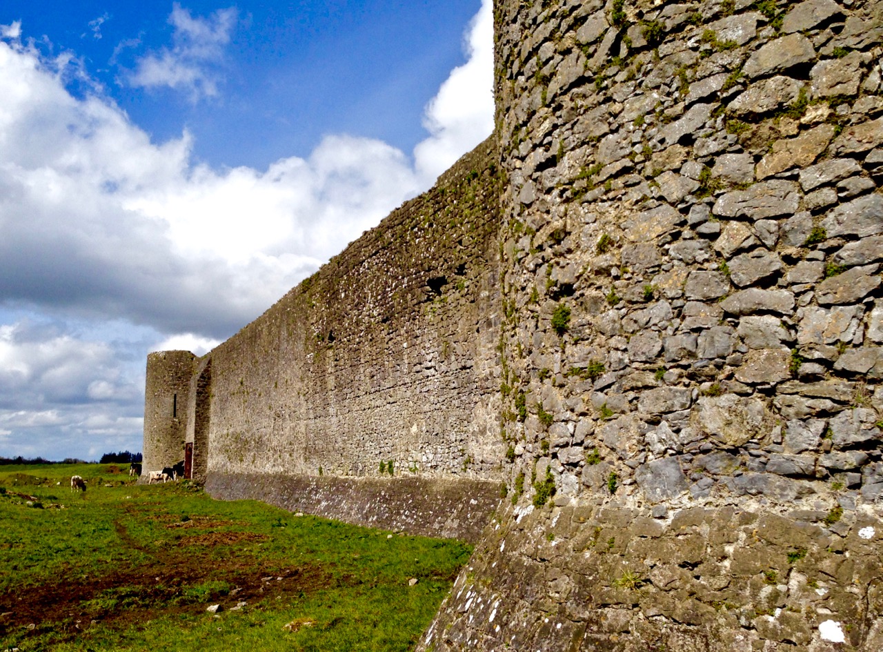
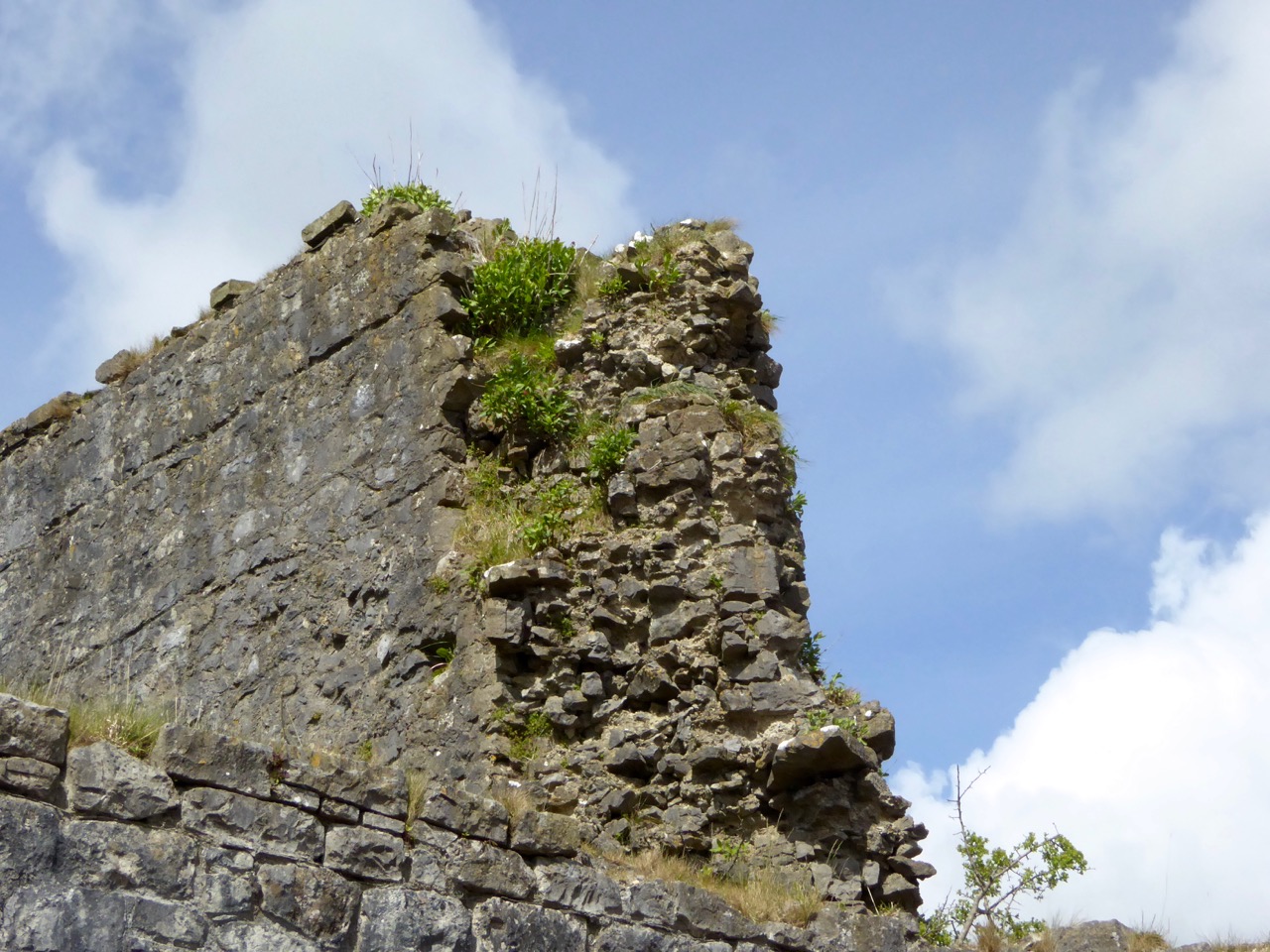
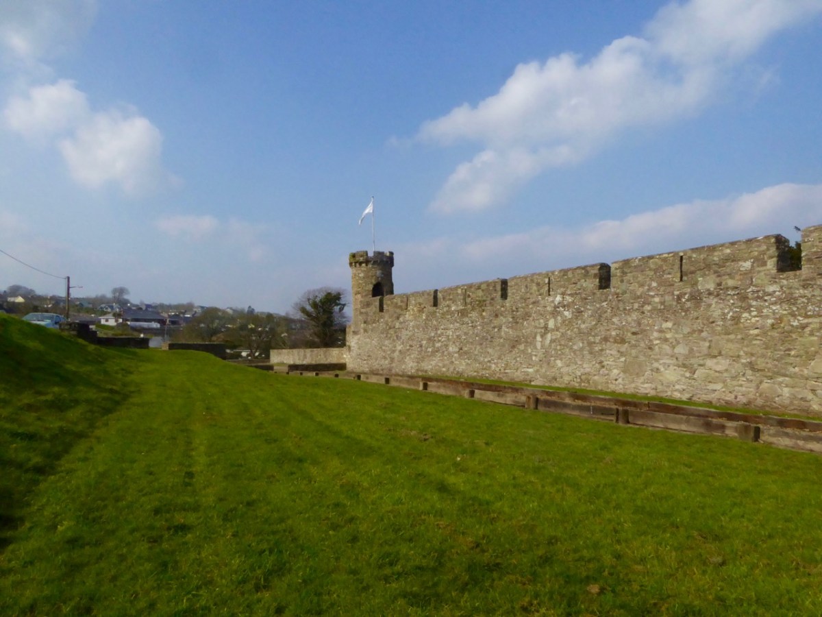
Interestingly, there is no sign, on our map, of the large star-shaped fort that Speed labels The New Fort and that subsequently became known as Elizabeth Fort. It was started in 1601 by George Carew (the original owner of this map collection) built of earth, stone and timber.  This supports a pre-1600 date for this map. Elizabeth Fort is still very much part of the Cork landscape, with its massive walls still dominating the south side of the river (above).

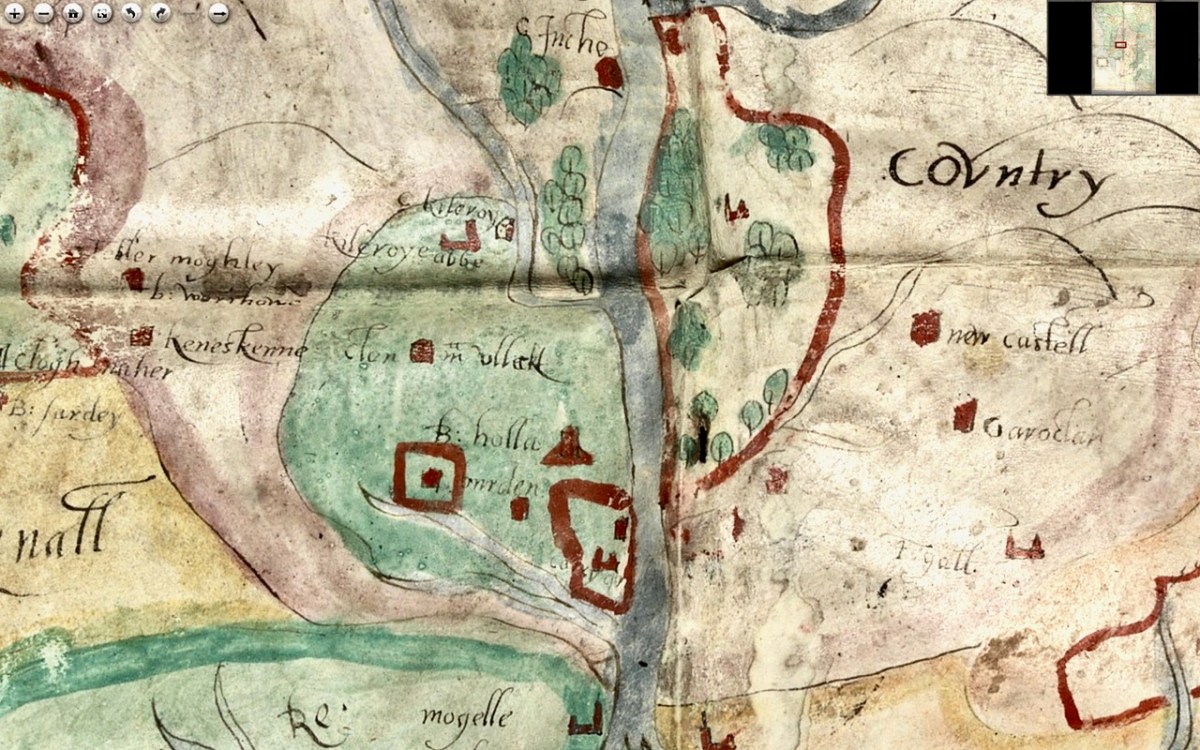
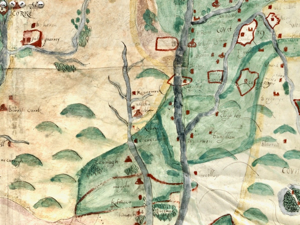
As we progress west along the Lee, the land is shown as wooded and there are several establishments by the river and its tributaries. I recognise Kilcrea Castle and Abbey (given here as Kileroye), but I’m sure others, more familiar with this landscape than I am, can add more.

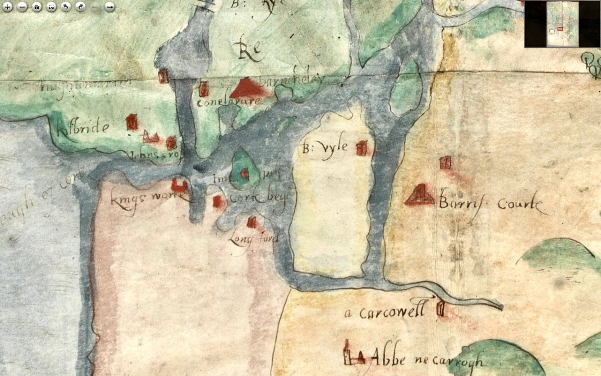
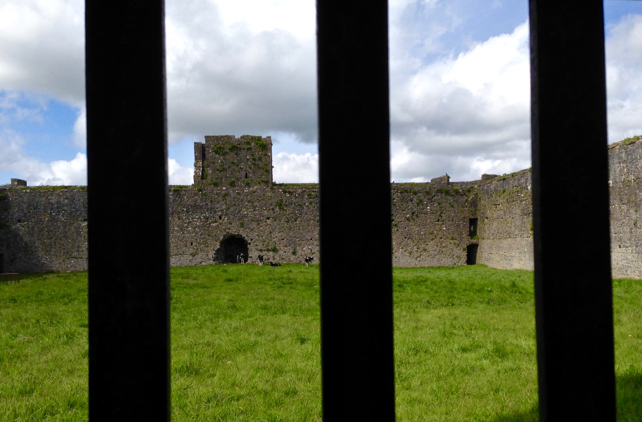
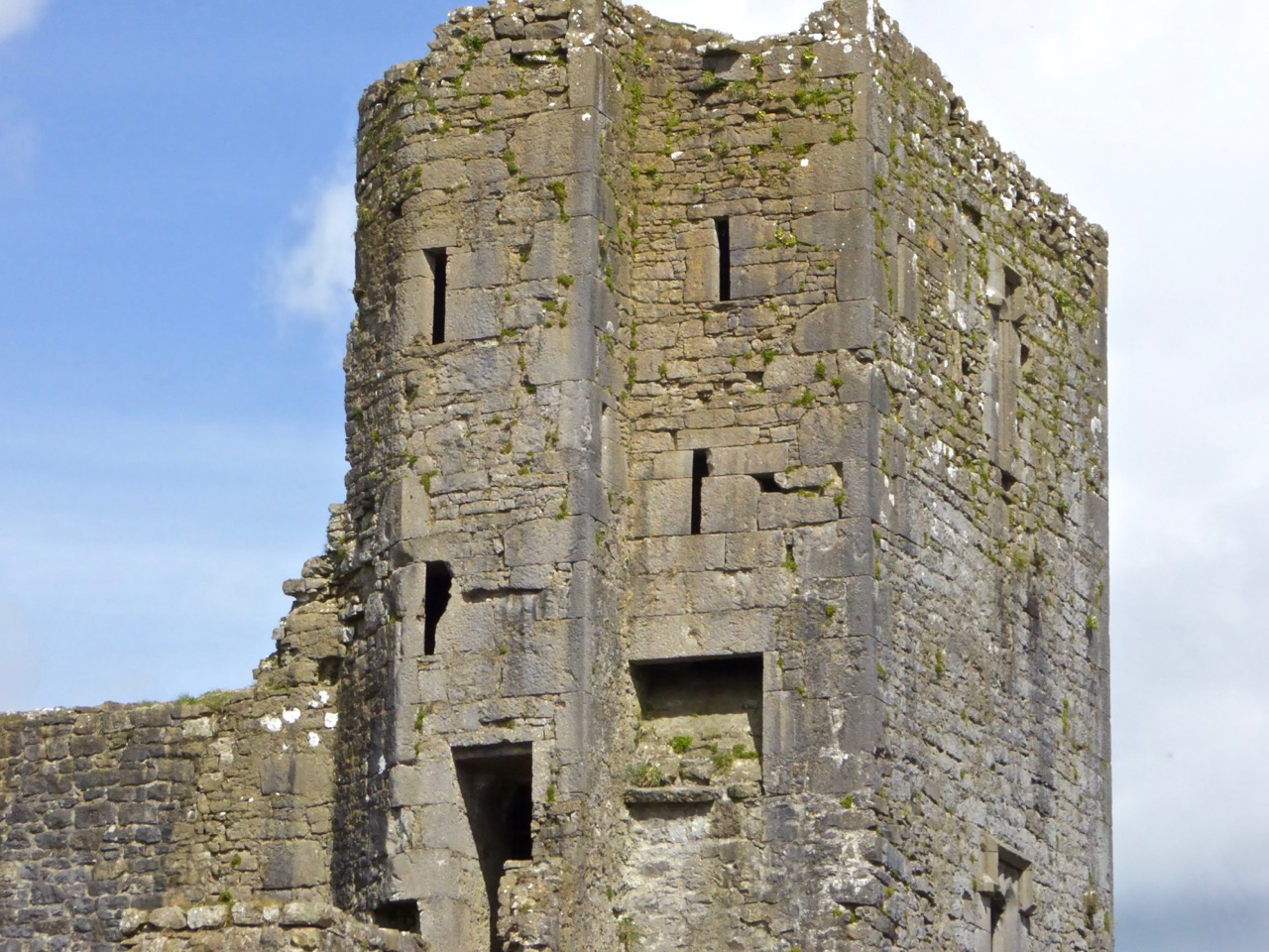
Cork Harbour, as might be expected, has many towers, the main one among them still standing is Barry’s Court (barris courte), soon (we hope) to be re-opened for visitors and also Belvelly (B:vyle), magnificently restored by a private owner. Corkbeg Island and Castle are shown, as well as several other castles on either side of the delta. Cloyne is of course indicated, as it was an important ecclesiastical centre.

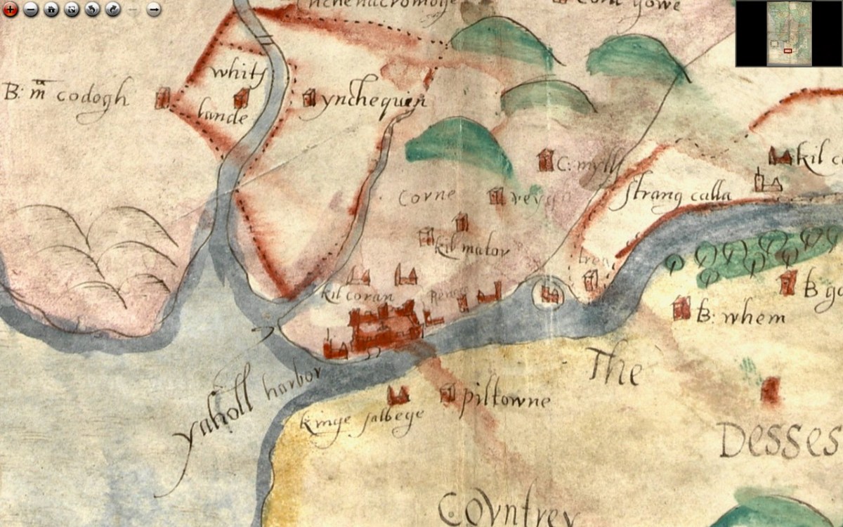
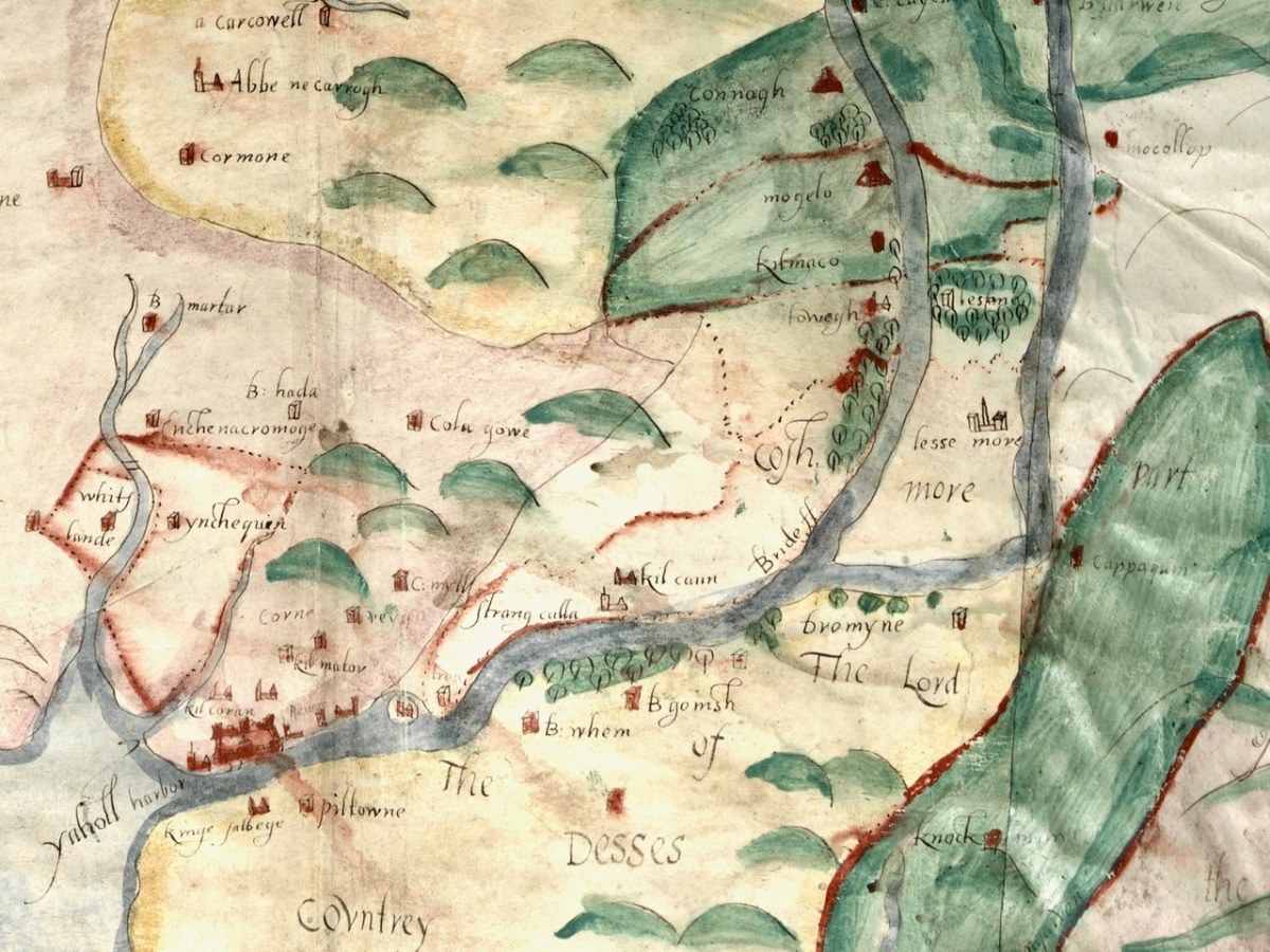
Moving now to the Blackwater/Bride River system, we see perhaps as populous and encastellated an area as around Cork, especially along the two rivers, which were navigable for many miles inland. Youghal is shown as a walled town, guarding the mouth of the harbour but also a large commercial and trading centre.

We have written about Youghal before, and specifically about its well-preserved stretches of wall – an unusual feature of Irish towns as very few medieval walls have survived.

I am reproducing below the map from Pacata Hibernia I used in my Youghal’s Walls post. As with Cork, it can help us to understand a bit more about Youghal. Note, for example, the South Abbey clearly shown outside the walls on both maps.

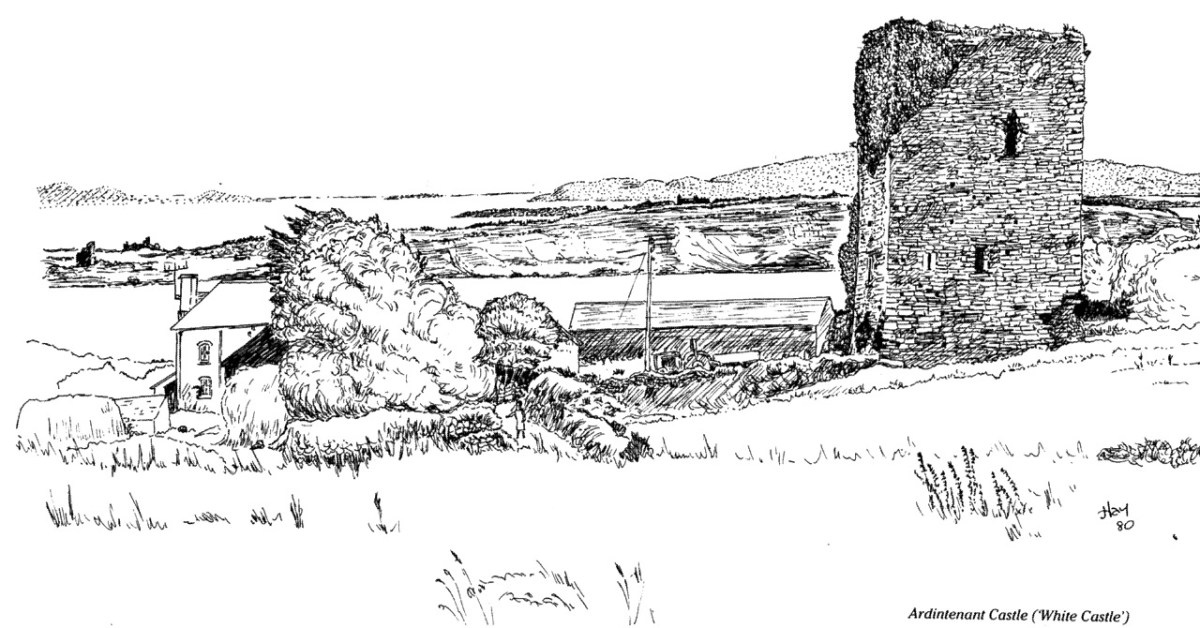
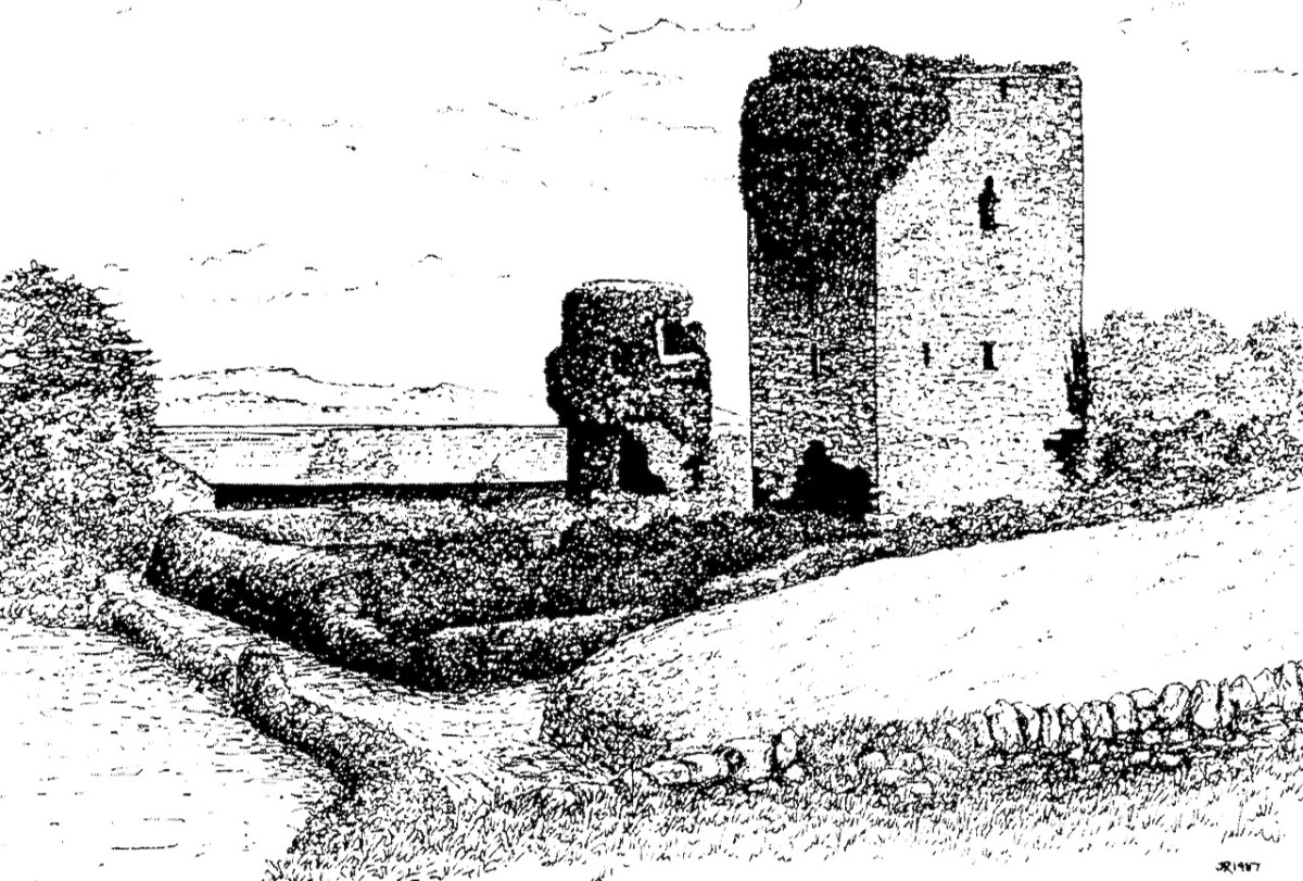
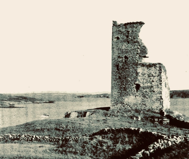
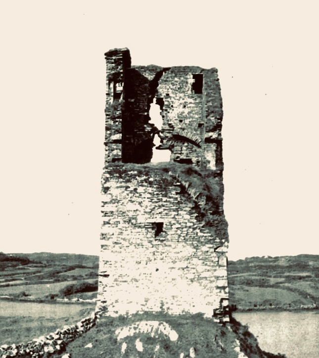
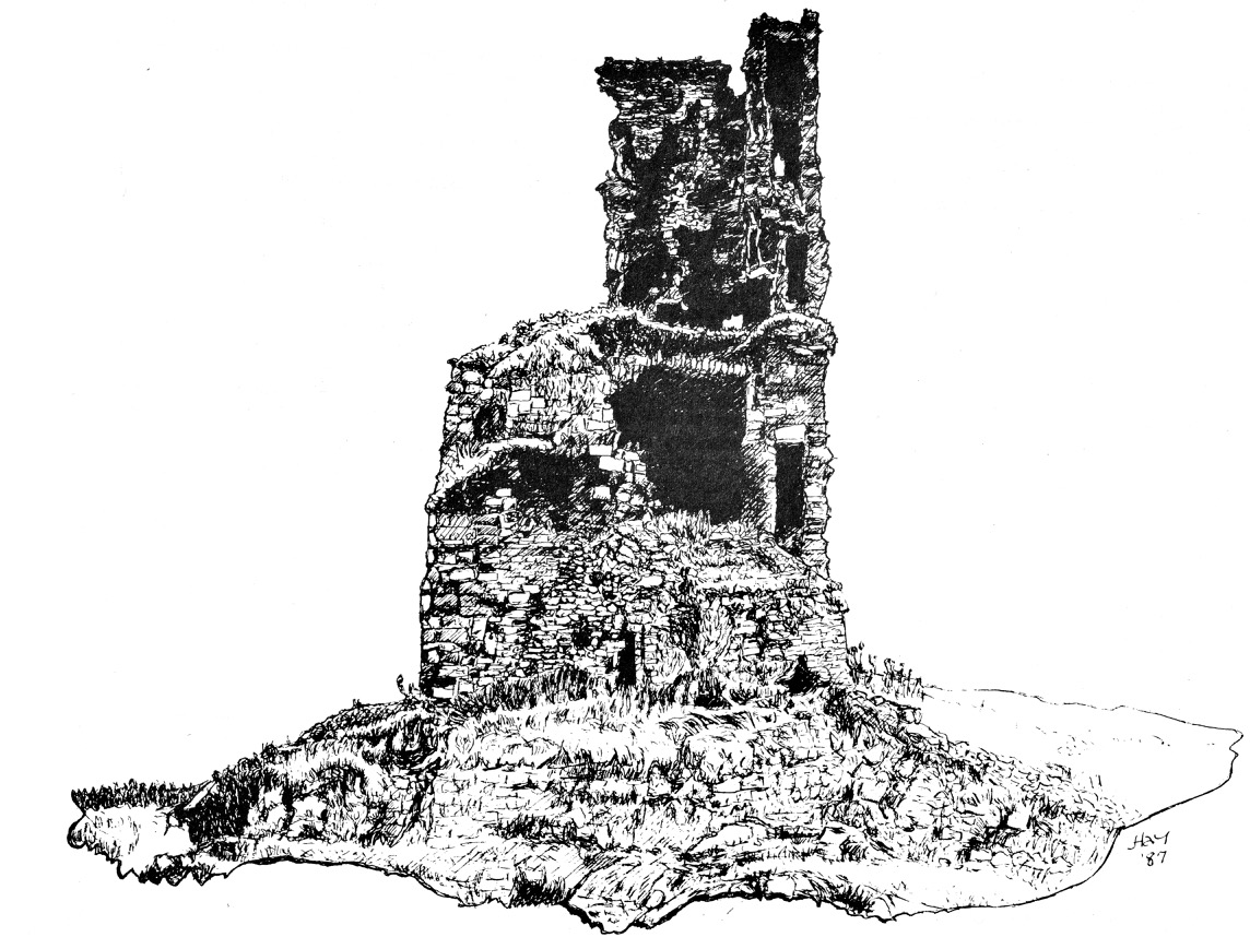
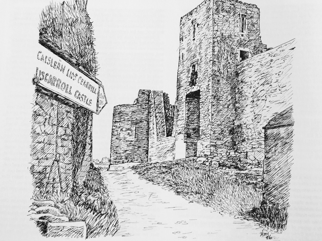
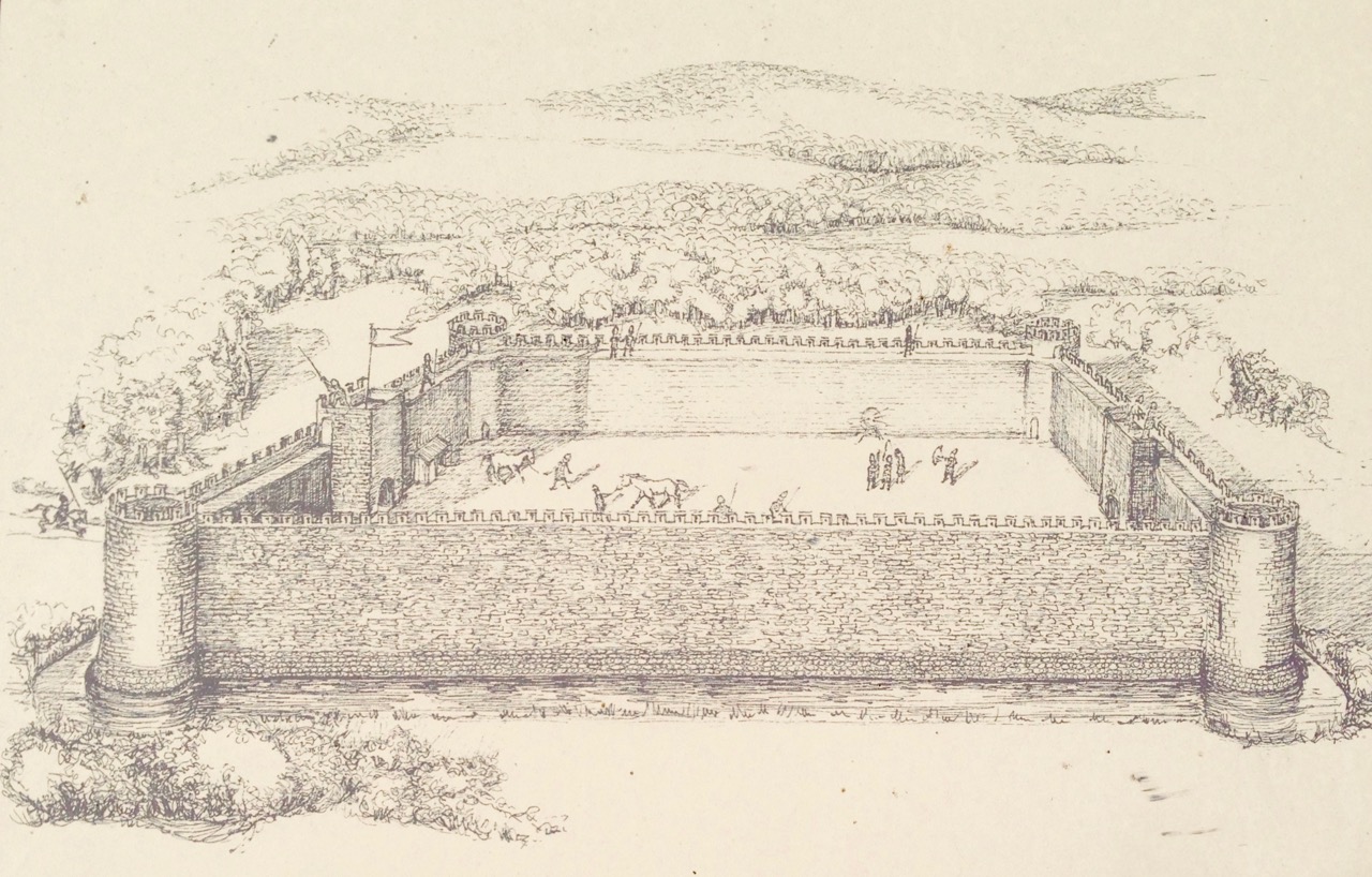
Upriver is Strancally Castle – not the more modern manor house, but the original tower house of which only a vestige remains down by the river. Also easily discernible is Pilltown in modern-day Waterford and Inchiquin, a townland east of Youghal. Inchiquin Castle is now the ruins of a round Anglo-Norman masonry tower which went through tortuous changes of ownership but was eventually occupied by in the fabled  Countess of Desmond who in 1604 died at the age of 140 by falling out of an apple tree. The castle was then seized by Richard Boyle, Great Earl of Cork, who, along with Walter Raleigh, is closely associated with Youghal and the Blackwater River. The drawing of Inchiquin below is by James Healy from his marvellous book The Castles of County Cork.

Boyle’s Castle (it’s still there) was in Lismore, but at this point lesse more is shown as a church on the banks of the Blackwater, not the centre of power it became with Boyle’s ascendance.

Castles, towns and churches line the Bride and the Blackwater, showing how important these rivers were at a time when the best way to traverse the country was by water.

I’m going to leave it there, although I just might come back to this map at some point in the future because, well, it’s so darn interesting and it’s fun to try and puzzle out the names. I hope I have supported my thesis that this map must date to before 1600. It is most likely another of those made for the purposes of identifying property in order to confiscate and carve it up during the Plantation of Munster. Please do visit it for yourself and see what you can find – additions always welcome in the comments section below.

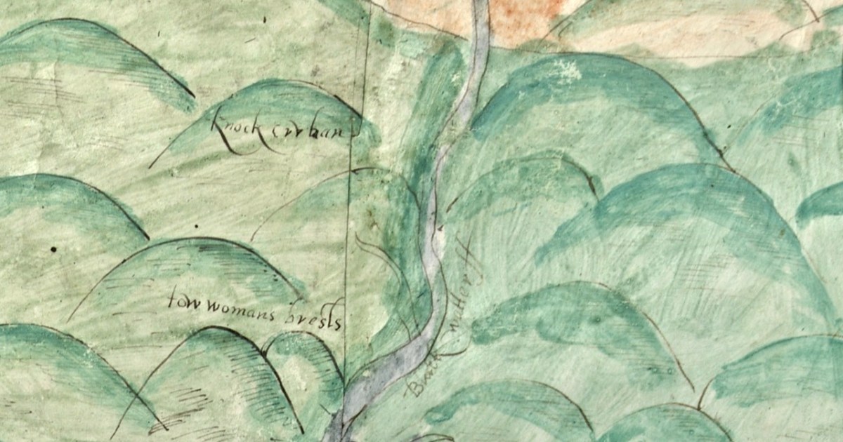
OK – one last image – the source of the Blackwater is shown in this one. What do we call these mountains now?

A Map of the County of Cork, Part 1

A Map of the County of Cork, Part 2

Ardintenant Castle

Home of the Taoiseach, or Head of the Clan, Ardintenant was one of the most important of the O’Mahony Castles of Ivaha (or what we now call The Mizen). Fortunately, it is relatively intact and we can observe and record much about it. The drawing above was done by James N Healy for his magnificent book on The Castles of County Cork. This post is another in my series on The Castles of Ivaha.

First the name – Ardintenant has been variously interpreted as coming from Árd an Tine (Ord on Tinneh, Height of the Fire), Árd an tSaighneáin (Ord on Tye-nawn Height of the Flash, or Beacon) or Árd an Tiarna (Ord on Teerna, Height of the High Chief). Any of these would be apt, since tower houses by the sea like this one (viewed from the sea, above) could be used as navigation beacons, possibly with a fire on the battlements. We also know that it was the residence of the head of the O’Mahony Clan, even though it was not the largest or most elaborate of the O’Mahony castles. Locally, it is also known as White Castle, which may refer to the white render that once made it stand out in the landscape (for more on render and castle colours, see the discussion on Kilcoe Castle). The photograph below demonstrates that it was prominent on the landscape and close to, although not right on, the sea.

It now stands in the middle of a working farm, surrounded by stone buildings that are picturesque and notable in their own right.

Ardintenant is typical of castles built during the 15th century by Irish clan chiefs – wealthy and powerful and anxious to assert their claims on land and sea.

Dermot Runtach (the Reliable) succeeded in I400; his life and the lives of his sons spanned the Fifteenth Century. He was celebrated as a ‘truly hospitable man, who never refused to give anything to anyone’ . . . The period of 1400 -1500 was the most peaceful and prosperous period in the history of the clan. The Ivagha peninsula was protected by the sea on three sides and the family became wealthy from the exaction of dues from the continental fishing fleets; trade also enriched them, causing long-standing enmity with the citizens of Cork. Tradition relates that the majority of the O’Mahony tower houses in Ivagha were built by or for the sons of Dermod Runtach. The date of Dermod Runtach’s death is recorded in the Annals of Loch Cé as 1427.


THE TOWER HOUSES OF WEST CORK
MARK WYCLIFFE SAMUEL, 1998

Dermot Runtach’s sons were the castle builders. Conor Cabaicc succeeded his father in 1427 and remained Taoiseach for 46 years, embarking on an ambitious program of construction to provide castles for his sons and brothers, beginning with Ardintenant. He died in 1473, by which time probably all of the castles of Ivaha were built and occupied by various members of his derbfine (extended family). Cabaicc means of the exactions (or forced tributes), although it is possible that Conor was more benignly known as Cabach – meaning talkative. His brother, Fineen, the Táiniste (heir-in-waiting) built Rossbrin Castle, about which Robert has written, and which is the castle in our view at Nead an Iolair. Rossbrin and the remains of a small tower on Castle Island are both visible from Ardintenant.

While there is evidence that other O’Mahony castles were built on pre-existing fortifications such as promontory forts (see Three Castle Head, for example) or ring forts, this is most visible at Ardintenant, where the ring fort can still be seen as a circular rampart around the tower house. You can make out part of it in the photo above. Another unusual feature is the survival of a single flanking tower, along the line of the ring fort and across from the tower house, although there may have been more than one originally, since the 1840s OS map shows what could be a second one – the leftmost building on the line of the ringfort below. Note that farm buildings also dot the site even at this early stage.

The possible second flanking tower had disappeared by the time the next series of maps were produced, around the 1890s. The farm buildings have changed as well.

In his marvellous paper on Ardintenant Castle in Mizen Journal 11, 2003, John Hawkes investigates the history and construction of the castle and provides elevation and plan drawings. I am grateful for his scholarship and thoroughness, which has informed the following description of what is left at this site, as well as provided illustrations.

The presence of the ringfort raises an intriguing prospect since it appears that instead of the usual rectangular bawn, surrounded by a stone wall (see the illustration in this post), we have a round bawn, with the stone wall built on top of the bank of the ringfort. Although that stone wall is not obvious now, it is noted in the description of the ring fort in the National Monuments survey. Thus, what we have here is a hybrid ring fort/tower house – a sensible adaptation of a pre-existing fortification and a continuation of the site as a high-ranking residence. The National Monuments survey also refers to an external fosse, although traces of it are hard to see on the ground. If it was originally a substantial ditch, another possibility is that the bank was surrounded by a moat. 

As with all of the O’Mahony Castles, Ardintenant is the type of tower house known as Raised Entry, that is, the ground floor door allows access to the public areas of the castle, while the door above it, originally accessed via a wooden stairway, gives on to a set of steps up to the private area.

The first two-and-a-mezzanine floors are covered by a vault. This set-up was partly defensive – the upper floors could only be accessed through this raised doorway and staircase – and partly for security, in that the vault was a barrier should a fire break out on the lower floors. The doorway to the left leads to a garderobe, while on the right are two deeply splayed window embrasures.

At Ardintenant, as with Dunmanus, the ground floor has been in use as a cow byre. It is normally impossible to access the upper floors, although those who have done so report that it is in good condition. That floor is reached by means of a mural staircase that rises from the raised entry.

A second staircase, in this case a spiral, gives access from the upper floor to the wall walk. This was not a castle built for comfort – in common with the other 15th century O’Mahony castle it had no fireplaces and very few windows.

Above the vault was what Hawkes calls the Great Hall. One large room, accessed via the mural staircase, the only notable feature of which is are deeply splayed window with seats in the embrasure. Picture the Lady of the house seated here, trying to catch whatever light she could as she bent over her handwork. 

In one corner of the Great Hall, the spiral staircase led up to the wall walk (what Hawkes calls the Allure). While nothing remains of these battlements now, we can assume that there was a walkway around the roof, perhaps with Irish crenellations and a sentry box.

The flanking tower (above) is covered in ivy, so it’s hard to make out details. It may have looked a bit like the one Westropp called The Turret, at Dunlough.

It’s much smaller than the castle, rectangular, and three stories high. The illustration above, by Jack Roberts, indicates the relative sizes. The way in was from the level of the curtain wall and each floor was connected by a ladder, except for the wall walk/allure, reached by a spiral stone stairs. 

Hawkes tells us that “its function appears to have been to accommodate hostages.” He bases that on the absence of a ground level entry (the current hole on the ground level having been broken through in more recent times), so that the ‘dungeon’ was accessed through a trap door from the room above, which in turn he calls a ‘detention room.’ See my post on Dunmanus for a discussion of possible functions for rooms like the ‘dungeon.’

Ardintenant is still standing and intact, but a lot of the base batter – the broad stone base that gives it its strength and stability – is missing and holes have been punched through the walls in the past.

Along with the other extant O’Mahony castles, its continued survival cannot be taken for granted. It’s a listed monument on private land, and Ireland’s complicated heritage laws means that it can’t be deliberately damaged, but conversely, there is no onus on the landowners to conserve it at their own expense. All fingers crossed that it remains standing for ages to come.

Brian Lalor’s sketch of Ardintenant Castle from 1987, from his field notebook

O’Donovan Country (Sweet Ilen – Part 6)

Here’s a forerunner to Roaringwater Journal (above)! Philip Dixon Hardy lived from 1794 to 1875 and described himself as a poet, bookseller, printer, and publisher. He was the first to use a steam-powered printing press in Ireland and was the editor of The Dublin Penny Journal which was published every Saturday between 1832 and 1836. If you scroll through the contents you will see articles on all aspects of Irish life and accounts of many of his travels through the Irish countryside, including a series of ‘Rides through County Cork’. He was undoubtedly a man after our own hearts!

Continuing our own series of travels, exploring the Ilen River, we can’t help comparing our impressions of Castle Donovan (above) – which overlooks the Ilen after it has cascaded down from the summit of Mullaghmesha and broadened out to cross the plains of Cork County – with those that are recorded by Philip Dixon Hardy as he journeyed over the same terrain in 1828, almost two centuries ago.

The upper picture is taken from the Ilen plain looking north, with the castle tower set against the high mountains beyond. Above is our earliest known photograph of the castle: it comes from the Lawrence Collection, National Library of Ireland, and could date from the 1880s. Juxtapose this with the Dublin Penny Journal view, 50 years before that, shown under our header at the top of the page. Bear in mind that Hardy carried out most of his travels on foot:

. . . We will now suppose the the tourist who rejoiceth in the splendour of a wheel carriage has proceeded without any interruption to Bantry. We will act in the charitable capacity of guides to the humbler pedestrian. Him we would advise to select the old, or northern road, leaving Dunmanway to the west. Thence it proceeds to the lofty hill of Mielane, and surmounting a rising ground beyond this eminence, the vale of Castle Donovan (which forms the subject of our sketch) opens on the sight. It is hard to conceive of any thing more wild, more desolate, more lonely, than this savage vale. … I reached the eminence which commands it from the east, about two in the afternoon of a warm sunny day. Trees there are none in this district, and the heathy covering of the hills was incapable of showing any marks of the advancing season. In the centre of the vale beneath me, was the tall, castellated tower; an extensive marshy meadow lay beyond it, bounded by the steep rocky hills of Mullaugh-Nesha, and its peaked brethren. . .

Philip Dixon Hardy, 1828, from The Dublin Penny Journal

The Castle itself has a fairly well recorded history, although its origins are unclear. James N Healy – The Castles of County Cork, The Mercier Press 1988 – suggests that the first fortification on this site dates from the early 13th century, but the present building is more likely to be 16th century. There is a carved stone in a window embrasure on an upper floor which bears the date 1626, but Healy suggests that this marks a later restoration of the castle, and gives a probable date of construction between 1560 and 1584.

The castle was traditionally the seat of the Clann Cathail sept of the O’Donovans, and was first named ‘Sowagh’. I can’t find any origin for this name. Healy gives an intriguing story:

. . . A local story is told of how O’Donovan and his ally MacCarthy Duna hanged a protestant woman at the castle in 1641, as a result of which the curse of a corroding drip from the main arch was placed on the building. This would not cease until the demise of the last of the family: the castle does not appear to have been lived in again.

James N Healey – 1988 The Castles of County Cork

It is recorded that Cromwell’s officers attacked the castle and it was left in ruins. Returning to The Dublin Penny Journal, Philip Dixon Hardy describes his exploration of the remains:

. . . I diverged from the road to examine the old castle; it is founded on a rough rock whose surface, forming the floor of the vaulted hall of the castle, retains all its original inequalities. Strange notions of comfort must our ancestors have had! Here were men, possessed of a large tract of country, sufficiently wealthy to build several castles; and in this one, the constant residence for many years of a principal branch of the family, the floor of the hall is bare rock, which never has been levelled, and which is intersected with two or three ridgy indentations, nearly two feet in depth, and extending almost the whole length of the apartment!

PHILIP DIXON HARDY, 1828, FROM THE DUBLIN PENNY JOURNAL

This is what Hardy is referring to – in fact it’s not ‘the vaulted hall of the castle’! It’s the lowest floor – at ground level – and was in all likelihood a store or cattle shed. It might even have been a dungeon. The main ‘hall’ of the castle is on an upper level.

The castle structure was stabilised by the OPW and public access to the grounds was granted in 2013. Restoration works included the replacement of key elements of the masonry to prevent further decay. The ‘peep-hole’ above allows a view by a sentry located just inside the entry door of who might be standing outside: perhaps an undesirable character (below). Actually, rather than a peep-hole, this little tunnel through the wall was for a chain that secured an outer iron gate called a yett.

When you visit Castle Donovan, look over the low wall to the west of the tower itself. You will see an archaeological feature which is quite rare today, but was once common all over Ireland from early times: a cereal-drying kiln (also called a corn-drying or grain drying kiln).

What is a cereal-drying kiln? Here is a good summary, from Irish Archaeology. It looks almost megalithic – and the earliest one dated so far goes back to the Bronze Age, but there are many that are medieval, and this one at Castle Donovan is likely to be contemporary with the castle itself. The structure has a fire-pit (below) and trays of cereal were placed above the fire, and in this case under a capstone, presumably protecting the corn from wind and rain.

This extract from the 25″ Ordnance Survey map (late 19th century) shows the castle overlooking the Ilen River and, to the south, the bridge and the old school. To finish off this episode in the Ilen series, we will pause at this bridge. There’s plenty to see – good views back to the castle from the arches of the stone bridge; the site of the old National School. There is no sign of the building today, but there is a memorial stone:

This is from the Duchas Schools Folklore Collection, dating from 1937:

. . . Walkers: it was no uncommon thing for people to walk to and from Cork in olden times – often carrying baskets. Tradition has it that a woman Magg Hourihan of Deelis did the double journey on foot in one day (approximately 90 miles). Biddy Regan of Castledonovan is credited with the same feat – The occasion in both cases being the payment of Rent (which at that time was often paid through Cork butter factors). Herewith is a direction given to people who were unacquainted with the road – Bí ag dul soir, soir, soir – go bfeidir séipéal ar thaobh do láimhe deise ni fada uait Corcaig annsan.


Seán Ó Súilleabháin, múinteoir Deelish Co Cork

Previous episodes in this series: Sweet Ilen : Sweet Ilen – Part 2 : Sweet Ilen – Part 3 : Sweet Ilen – Part 4 : Sweet Ilen – Part 5

Looking at Rossbrin

Last week we talked a little about the history of Rossbrin’s medieval castle, and the importance of this natural inlet as a historical centre of fishery, scholarship and European culture. Rossbrin Cove stills serves as an anchorage and refuge for sailing boats on the edge of Roaringwater Bay, but is now a peaceful haven, with only the sounds of the shore birds and slapping masts to lightly disturb an overriding tranquility that gives the place a very particular atmosphere. Our photograph (above) is taken on the boreen going to the castle; on the skyline in the centre is a wind turbine, and just below that is Nead an Iolair (Irish for Eagle’s Nest). The picture below shows the eagles wheeling over our house, with Rossbrin Castle and our view to the Cove beyond.

I have been exploring images of the Cove and its castle – some historic photographs and a few artists’ impressions. As it’s right on our doorstep, we have taken many pictures of Rossbrin during our years here. I am also sifting through a few of these.

Ten years ago, the west of Ireland experienced an exceptional snowfall, and above is a photograph taken by our near neighbour, Julian van Hasselt, before we arrived. Mostly, our weather is relatively mild due to the effects of the gulf stream on the south-western coast. The castle can clearly be seen here, beyond the fields of Castle Farm. This view of our house (below) was also taken in 2010 by our neighbours Dietrich and Hildegard Eckardt:

I showed a couple of early photographs of the castle last week. Here are two more taken before a substantial part of the ruined structure was toppled by a storm in the 1970s:

It’s good to see a bit of context, so here is another winter view of the castle on its rock with Castle Island behind. That island was also part of the O’Mahony territory. It is farmed by its present owner but no-one lives there now. You can make out the ruined castle on the island by the shore, just to the right of centre; it’s one of many that can be seen on, or close to, the shores of the Bay.

Let’s have a look at some of the art works that feature the Cove and the Castle. Jacqueline Stanley was one of many artists who was attracted to the beauty of West Cork. Now in her nineties, she moved from England to Ireland in the mid 1970s and purchased the old School House at Rossbrin as a country retreat: it has only recently changed hands.Here are two of her works, depicting Rossbrin. You can find more on her website.

I particularly like this view (above) which was painted by Jackie from the vantage point above the high road going down to the Cove, close to the remains of the copper mine at Ballycumisk. Last week I showed a painting by Geraldine van Hasselt, Julian’s mother, also from the 1970s. Every painting or photo is a historical document – and important to retain, in view of the fragile nature of the structure today.

Our friend Peter Mabey is an architect and artist. He has lived in West Cork for a long time: he and I were at college together in Kingston, Surrey, and were surprised to meet each other by chance in Skibbereen market a good few years ago now. Above is one of his attractive watercolours looking down towards the Cove. The vantage point looks remarkably like the one chosen by Jackie Stanley. Below is a drawing of Rossbrin from the monumental work The Castles of County Cork by the late James N Healy, published in 1988 by Mercier:

The ruin is a romantic reminder of past times, enhanced by the changing weather moods of Roaringwater Bay. This photograph, by Finola, emphasises the character of the place:

I can’t resist finishing this little two-part foray into the medieval remnants of our historically significant ‘centre of culture and learning’, which now languish on the edge of the waters below us with an artist whose work we admire: Peter Clarke, who writes and illustrates the Hikelines blog. His watercolour sketches are exquisite and always atmospheric. He has kindly allowed me to use his portrayal of Rossbrin Castle as my tailpiece. Thank you, Peter – and thank you to all the other artists who have been inspired by this remote and beautiful part of Ireland.

Liscarrol: Cork’s Keepless Castle

Liscarrol walls and towers

As soon as the Normans arrived in Ireland (1169) they set about building enormous fortifications, the like of which had never been seen in this country before. Dublin Castle was typical, but not a lot remains to be seen of the original shape. More accessible is Limerick Castle – a space enclosed by imposing stone walls with corner towers and a strong gatehouse. Few of these very early castles remain. Leask, in his Irish Castles, termed them keepless castles, since they had no central tower houses or keeps. (Regular readers of Roaringwater Journal will recall several earlier posts about castles – these refer almost exclusively to the much smaller tower houses, most of which date to the 15th century and later. See When is Castle…? Tower House Tutorial Part 1 and Part 2, and Illustrating the Tower House.)

Trim Castle with Keep

Trim Castle in Co Meath is one of our best examples of an early Norman castle with a central keep

Alongside the keepless castles, and gradually taking over in popularity, were built those in which a tower, or keep, was the dominant feature located inside those high curtain walls. These great Norman castles were the predominant form during the late 12th and early 13th century. However, in the late 13th century, for some reason, keepless castles experienced a resurgence and several were built around the country. Most of these are in a ruined state and of course some have entirely disappeared or been so altered as to be unrecognisable.

Liscarrol front elevation

In the middle of the village of Liscarrol in North Cork – this!

But there’s one (and only one) in Cork and it has has retained all its magnificent features. On a recent trip to Duhallow (mostly looking for holy wells with Amanda and Peter of Holy Wells of Cork) we rounded a corner on a country road approaching the village of Liscarrol and there it was – as unexpected as it was jaw-dropping!

bawn walls

Note the splayed base batter of the walls, providing a solid foundation

Liscarrol Castle was probably built in the mid-13th century by the De Barry family but eventually passed into the possession of the Percevals in the 17th century. It was besieged by an Irish army of loyalists in 1642, but was eventually subdued and retaken by the parliamentarians under Sir Hardress Waller, whereupon it was again occupied by the Percevals who owned it into recent history.  James N Healy, in his magisterial The Castles of County Cork provides a detailed account of the back-and-forth sieges of the 1640s, as well as a charming sketch of the castle as it was in the early 1980s, when the key could be obtained from a local pub.

Liscarrol by Healy

It was extensively repaired and stabilised by the Office of Public Works (OPW) on several occasions in the 20th century. The sad state of the walls can be seen in a picture from The Illustrated Dublin Journal of 1862.

Liscarrol from Illustrated Dublin Journal

The Illustrated Dublin Journal is available online through the kindness of the University of Illinois

There are several older illustrations of Liscarrol Castle and they show two features that are no longer obvious today. The first is a moat, which must have been drained a long time ago as the ground is dry around the walls.

Liscarrol Castle drawing

The second is an outermost fortification known as a ravelin – a triangular projection that would have been the first line of defence in front of the entry tower.

OLYMPUS DIGITAL CAMERA

Both illustrations above are courtesy of the National Library

Rubble Construction

A section through the wall showing the rubble construction between outer facings of worked stone

How did a keepless castle work? Quoting Prof Tadgh O’Keefe of DCU, the description of Roscommon Castle (another of the keepless castles) has this to say:

Earlier on in the 13th century, two Royal castles in Ireland at Dublin and Limerick were built- the first castles in Europe that were built as keepless castles with an encircling wall that included towers. The emphasis in castle design here was on the encircling curtain wall. This wall included large barrel towers used as storage and partly living space, with emphasis on a residential gate house.

postern gate

The enclosure of these castles then contained further buildings, possibly built from wood or mud. The move to a keepless castle design seems meaningless to us today until we start thinking about the difference this would have made in terms of castle defence.

castle behind bars

The interior of this enormous enclosure is now home to some bullocks

In a castle with a keep, the attacker would have stormed and overcome the walls first, and then attacked the keep where all defenders would have withdrawn to now. Defending the keep was dependent on a single gate/ door holding up, and the bawn then had to be re-captured as well. In a keepless castle, defenders withdrew into the super thick walls themselves, supported by food storage and living space in the towers. The walls contained arrow loops facing both sides of the walls, meaning both the bawn AND the outside of the castle could be defended at an advantage. So, in fact, the move to a keepless castle design was an ingenious innovation providing super safe castles.

Entrance tower

The entrance tower would have provided living space for the De Barrys and the Percevals. Note the garderobe chute high on the walls, and the entrance off the battlements

The entrance is one of the most impressive aspects of the castle. Many defensive features were deployed, including murder holes and a portcullis.

Liscarrol entrance

liscarrol signSome modifications to the earlier structure are visible here and there, although on the whole it remains truly a thirteenth century stronghold.

Later window features

Windows were widened, probably in the 15th century – the ogee heads are a dead giveaway

The only problem with Liscarrol Castle is that it is accessible solely on the outside – the inside was occupied by a small herd of young cattle. Given the amount of public money that has been spent on it, this seems an immense pity. Duhallow and its towns and villages are doing a great job at putting together interesting tourist experiences: Liscarrol Castle, unique and awe-inspiring, could be a jewel in its crown.

keepless castle pic

And to finish off in good old Irish tradition – there is, of course, a tune called The Walls of Liscarrol. Have a listen.