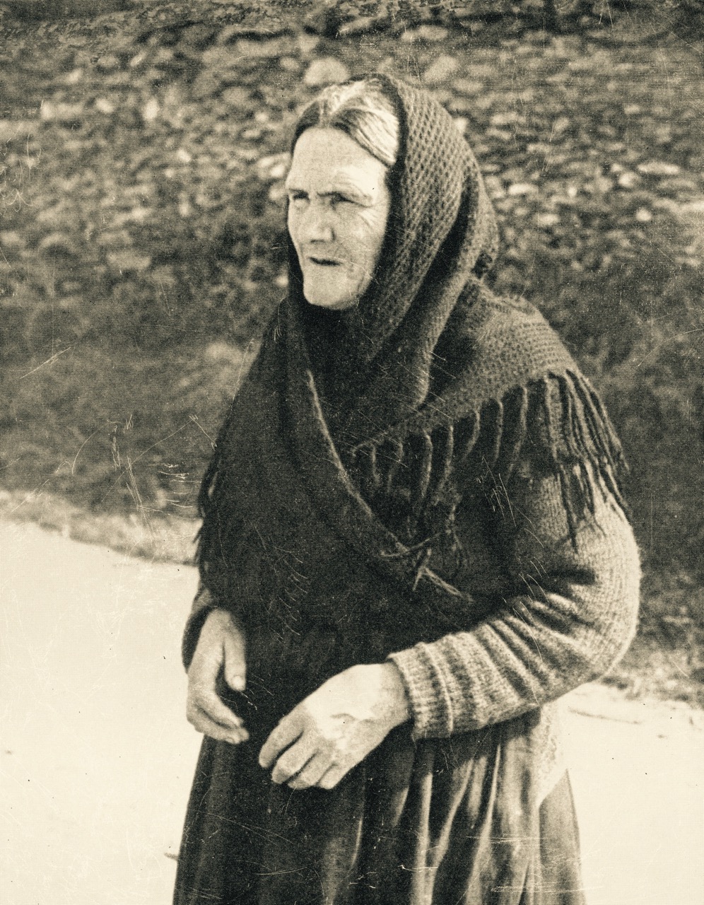
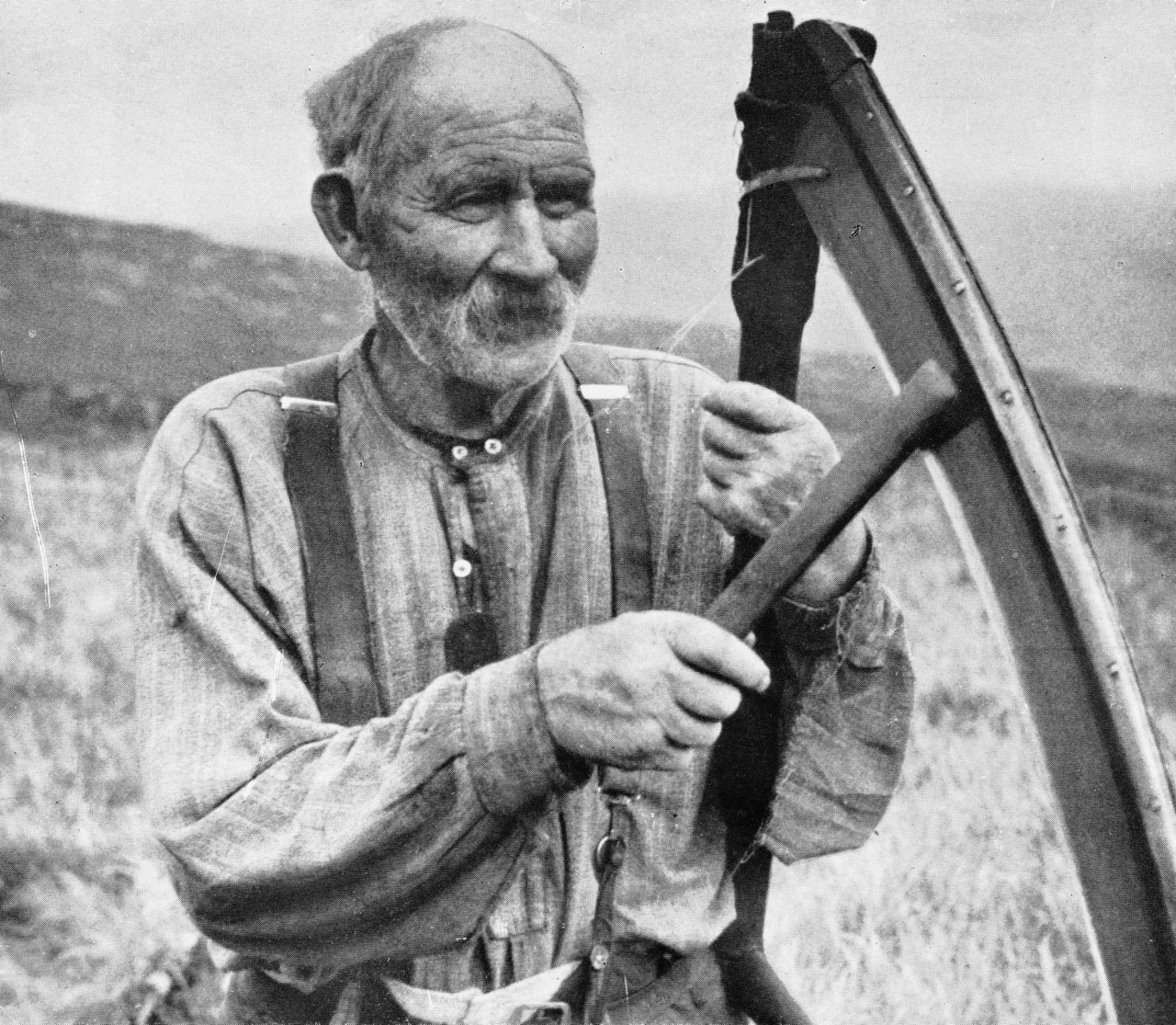
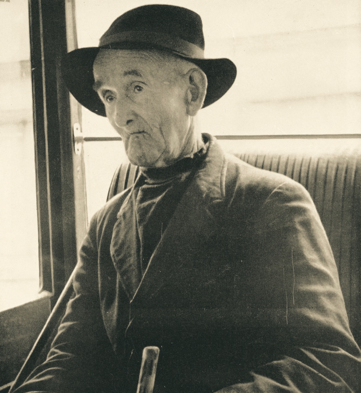
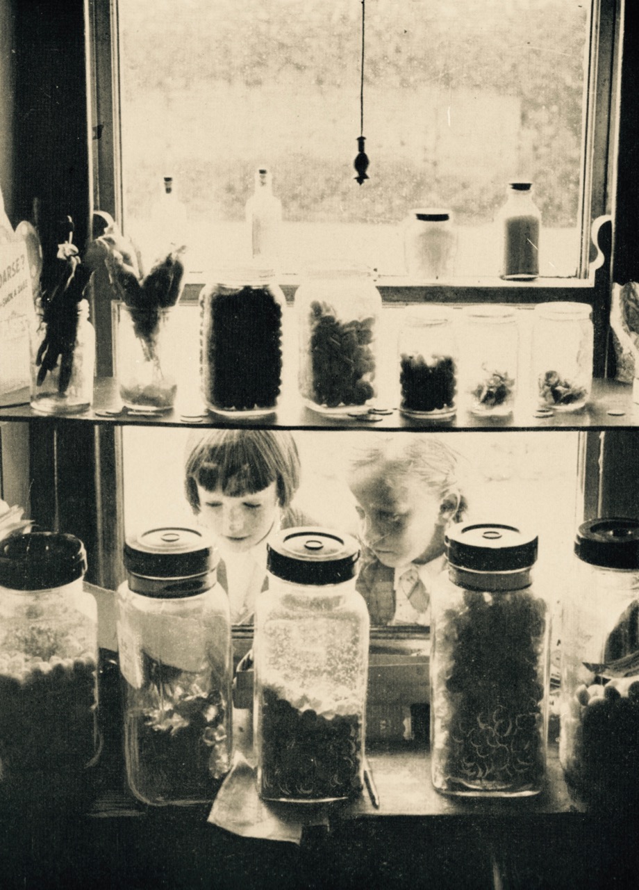
Old photographs are irresistible. The collection of Tomás Ó Muircheartaigh who travelled and photographed the west of Ireland during the 1930s, 40s and 50s is an invaluable documentary of the times in which he lived. Ó Muircheartaigh’s pictures record rural life and – most impressively – the people who lived it. This is a post, mainly of portraits, taken from a book of his work published posthumously in 1970, and now hard to find.
Tomás was President of Conradh na Gaelige (The Gaelic League) between 1955 and 1959, and his photographs appeared on the cover of many editions of the League’s monthly magazine.
The portraits, sadly, do not record the names of the subjects nor – often – their localities. We only know, on the whole, that his travels were centred on west Kerry and the Blasket Islands. The images, however, are powerfully evocative and time and place are, perhaps, irrelevant.
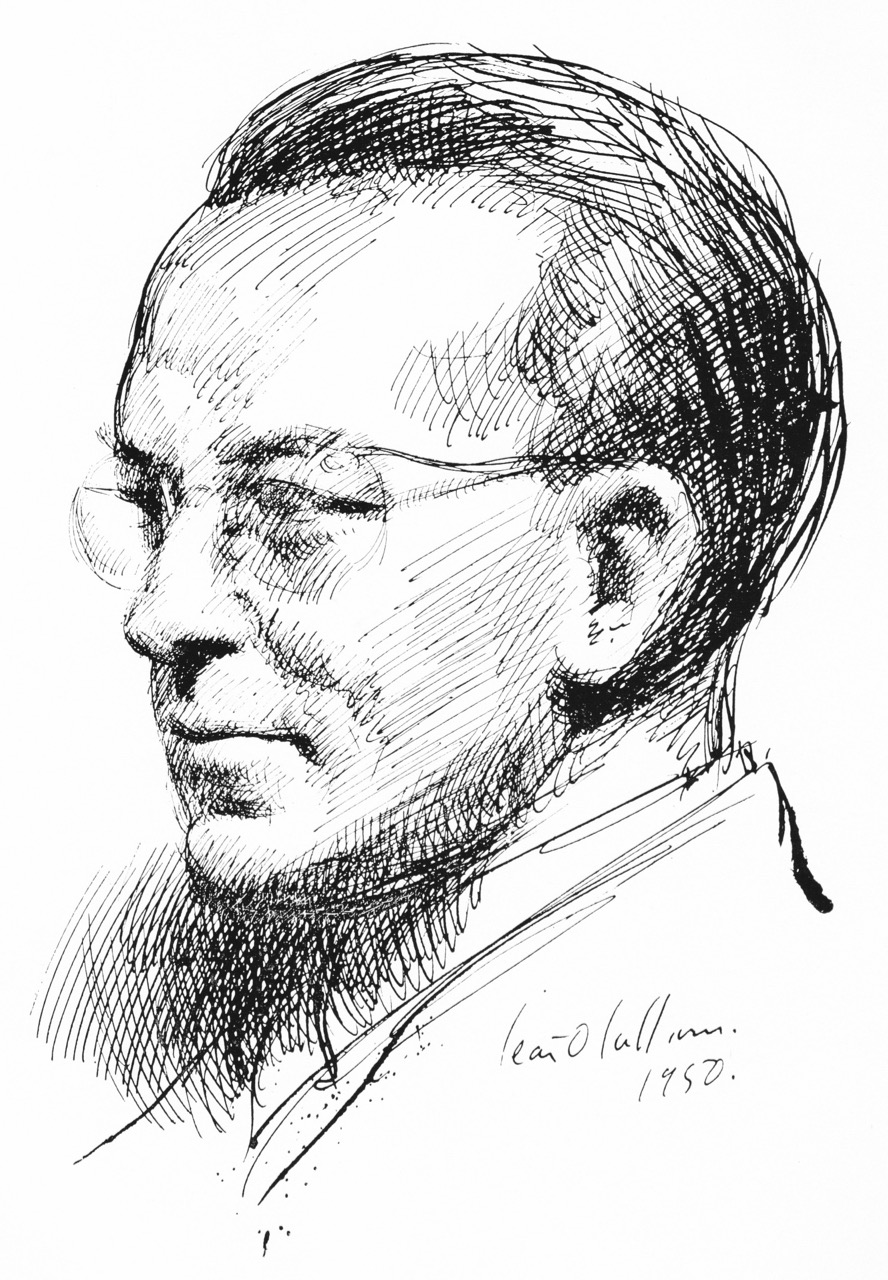
Tomás Ó Muircheartaigh 1907 – 1967, sketched by Sean O’Sullivan:
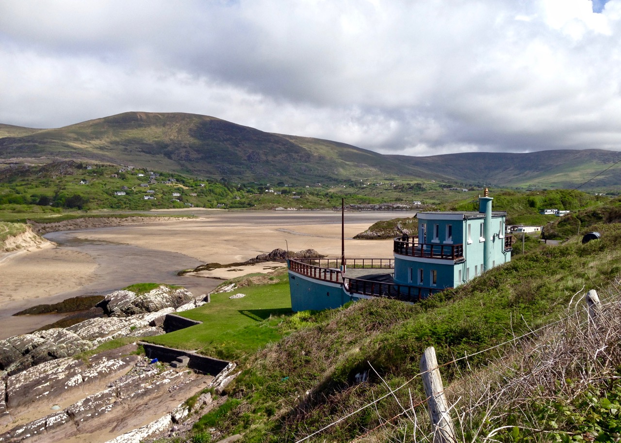
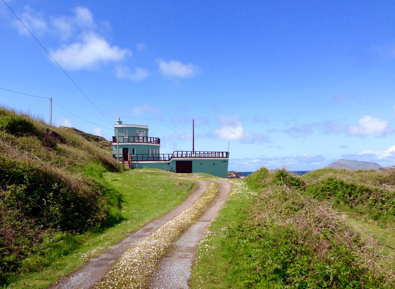
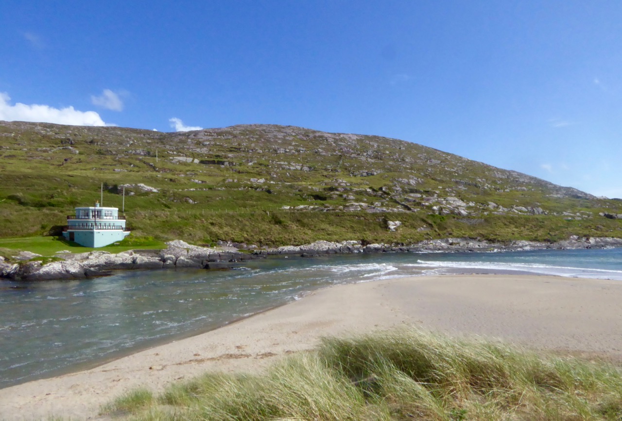
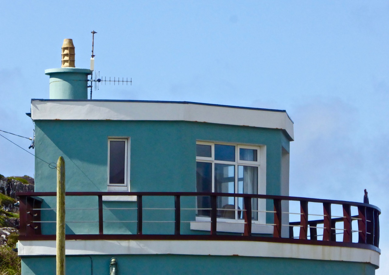
Adrift on the shoreline of Ballycarnahan townland in County Kerry is a most wonderful piece of architecture. It is a ship shaped house, seemingly half buried in the sand dunes, its prow and bridge emerging and facing one of Ireland’s most spectacular views.
The view from the Ship House: across the water is Derrynane, the home of ‘Ireland’s Liberator’ Daniel O’Connell (soon to be featured on Roaringwater Journal). The Kerry mountains make a splendid backdrop
The house in the dunes was built as a holiday home by Francis and Ros Horgan of Macroom in the early 1950s. It is still owned by the Horgan family. As an architect myself I wondered about the history of the design: did the inspired idea of the ‘ship’ come from the clients? Or was it dreamed up by the architect? In which case the clients would have to be commended for going along with such a daring (and witty) concept.
Houses made from boats and marooned forever on dry land are not unknown: below are a couple from California; the Kerry house, however, is a purpose-built ‘one off’. Architectural ‘ship’ symbolism can also be found elsewhere in Ireland: the new Library in Dun Laoghaire by Carr Cotter + Neassens Architects has a definite nautical theme, appropriate for its site overlooking Dublin’s Dun Laoghaire Harbour.
Dun Laoghaire’s new library – the Lexicon – in the right of the picture above, acknowledges its maritime setting (photograph courtesy The Irish Times)
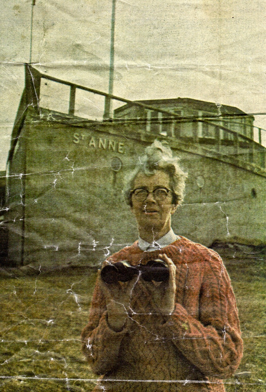
We were in Kerry visiting cousins of Finola: all of them were brought up in Lamb’s Head, just beside the Ship House. They were a mine of information on the house, which had been built by their grandfather Crohane Donnelly (he was named after the local saint) at a cost of one thousand pounds. Over breakfast this morning at Lamb’s Head, enjoying the same view across the bay to Derrynane House, I was delighted when cousin Annie came in with a newspaper cutting from the Daily Mirror dating from St Patrick’s Day 1969: the headline was Ahoy! It’s the Cosy Home that is Always Ship Shape, and it was all about the Ship House.
The house is named St Anne. I gleaned from the newspaper article that …she was one of Mrs Horgan’s favourite saints. A mass was celebrated when the house was “launched”, after the site had originally been blessed by Cardinal Griffin…
The upper deck of the three tier house – the wheelhouse – has a ship’s wheel which came from the HMS Pluto, which was being broken up in Cork. The lower deck, within the concrete ‘hull’, houses a garage and workshop, is known as ‘the hold’ and is lit by portholes. There is even a gangplank leading to the front door!
Quoting the Mirror: …Mrs Hogan, a quietly humorous Irishwoman in her fifties, explained how it all came about. “I’ve always had a great love for this spot, since I first came here at the age of five,” she said. ‘My husband and I used to come here every year for our holidays. We both loved the sea and boats.” She said that Mr Horgan, an engineering director and farmer from Macroom, Co Cork, worked on the plans with an architect. “First of all it was going to be a round house, then it just evolved into a ship. But,” she smiled, “I think that was what my husband wanted in the first place…”
In 1969 …The house now sprouts a TV aerial and has mains electricity. But Mrs Gorgan rather regrets it. “When we had a diesel engine for lighting, it used to chug-chug away. At night, looking across the bay, you felt you were sailing in a real ship right out at sea. I miss the diesel for that…”
Perhaps one day I will get to have a look inside the ship house – I wonder how the rooms are laid out? As well as bringing in the electric there are some obvious upgrades which have taken place – there are modern windows installed and the roof looks to have been renewed. But it’s still a holiday home, owned and used by the Horgan’s children. It must be one of the most unusual and eccentric holiday hideaways in Ireland!
Stop Press Since publishing this post yesterday, Cousin Annie has forwarded some more information. An album of photographs which were taken during the construction process was reproduced in the Caherdaniel Parish Magazine in 2014, with the permission of the Horgan family (owners) and the Donnelly family (builders). It’s a great contemporary record of an unusual project and some of those photographs are put together in this slide show – thanks, Annie!
This slideshow requires JavaScript.
Here’s the final picture from that collection, worthy of a place of its own. It shows the completed project and the Donellys who built it. Crohane Donnelly, Annie’s grandfather, is on the left…
Ros Horgan (pictured below in the Mirror article) deserves the last word: …Her eyes twinkled. “The archaeologists in years to come are going to have a lot of trouble with this one. They are going to ask: ‘In what era did they have concrete ships?’…”
Thanks to all Finola’s Kerry cousins and their families for their memories and information on the Ship House, and for the wonderful hospitality which they heaped upon us during our visit. And thank you to Finola for allowing me to use her superb picture on the header, which would otherwise have featured in her own Into The Kingdom post!
The Kingdom? No, we didn’t go to Britain – we went to Kerry. It’s always been called the Kingdom, possibly based on ancient Irish precedents, although other theories abound. Many people think it’s because of the sheer magnificence of the scenery, and I wouldn’t disagree.
Ballinskelligs Bay. The first photograph is also Ballinskelligs Bay, with a glimpse of the famous Skelligs Islands in the background – subject of a future post, we hope!
Our journey took us on the Ring of Kerry, along the south side of the Iveragh Peninsula, by the sea. This is prime tourist territory – bus after bus passed us and every lay-by was thronged with camera-wielding tourists, including us. We came back through the middle of the peninsula, through deep valleys and high mountain passes.
Not for the tour busses!
These are not roads that busses can manoeuvre through, so we had itmostly to ourselves, the locals, and a few tourists armed with small cars and good maps. I love this Iveragh backcountry. It’s where I spent my student days, conducting my research. I even recognised the place where I crashed my Honda 50 into a bog.
Although it seems totally mountainous, vast sheltered valleys occupy some of the hinterland of the Iveragh Peninsula
We visited two stone forts, the mighty Staigue and the lesser-known Loher, and of course some rock art. Staigue Fort is generally reckoned to be Iron Age (about 250AD), while Loher, although very similar, was built later, around the 9th Century.
Staigue Fort (upper), at the head of a long valley, commands views to the sea. Loher is also strategically sited with extensive views all around.
Wild flowers a-plenty on the dunes at Derrynane. Top: Sea Pinks and Sea Sandwort. Bottom: Pyramidal Orchid and Kidney Vetch
We searched in vain for the holy well devoted to Saint Crohane, patron saint of Caherdaniel – we’ll have to go back with Amanda to help us find it.
We didn’t find St Crohane’s well but when we finished our search, in twilight, this is what was waiting for us. The mountain range in the background is the Beara Peninsula in Cork
In fact, the primary purpose of our trip was to re-connect with cousins that I haven’t seen for about 45 years. The last time I saw Annie and her siblings they were kids, and we were all piled on to a donkey and cart in a vain attempt to get from Lamb’s Head to Staigue Fort. It’s a long story, but suffice it to say that the donkey came out the winner. Most of the family still live around Caherdaniel, in jaw- dropping surroundings, and we were accommodated and hosted with true Kerry hospitality.
Top: The view from Annie’s house, across to Lamb’s Head where the family grew up
Along the way we saw a house shaped like a ship (Robert has more – much more – about this!), had our first experience of bottle-feeding a lamb, and we watched Rex the sheepdog gently herd a flock of chickens into their pen for the night. We visited my cousin Betty’s grave – she died a few months ago, the heart of the family, much mourned. It was, we hope, the first of many visits, back and forth.
Abbey Island, Betty’s last resting place, must be one of Ireland’s most beautiful graveyards. To access it, you must walk across the sand and keep an eye out for high tides. The original monastic site was founded by St Finian in the sixth Century, although the ruined church, Ahamore Abbey, probably dates from the 10th Century.
This post is to give you a flavour for our neighbouring county and to show you why it is justly famous for its history and archaeology, but most of all for what is surely some of the most spectacular scenery in the world.
Scarrif and Deenish are the two islands out from Derrynane Bay. Uninhabited for 40 years, they are the site of salmon farms now. We walked down Lamb’s Head to get a better view of them.
As in West Cork, everywhere in Kerry you can see the traces of tiny settlements. Abandoned long ago, possibly after the famine, each field may have provided enough potatoes for one family. Now only the sheep graze peacefully.
We headed home through the Ballaghbeama Gap. On the south side is Ireland’s greatest concentration of prehistoric rock art. We wrote about this in our post Derrynablaha Expedition.
What’s an archaeological anomaly? When the National Monuments Survey was being undertaken, some stone structures didn’t quite fit the description of a particular class of monument. They may have been ancient – but how ancient, and what exactly were they? The term chosen for such mysterious pileswas ‘anomalous stone group’. Here’s the definition: A group of stones, usually standing, which cannot be classified as any other known archaeological monument type on present evidence. They may be all that remains or is visible of a partially destroyed or obscured archaeological monument which may date to any period from prehistory onwards.
Just a leaning rock?
But it’s not the only term used for uncertain monuments: enclosure is a vague term that can mean a multitude of things, and an ‘unclassified cairn‘ can be defined simply as a heap or pile of stones. In the last few months our explorations of the Sheep’s Head have turned up several anomalies. The only thing they all have in common is their spectacular siting, leading to an ultra-rewarding field trip.
Hiking to the cairn
Perhaps the most magnificently situated of all is the unclassified cairn on the mountain ridge above Kilcrohane. It’s right on the way-marked Sheep’s Head Way, so it’s easy to find. While it’s described as a cairn in the National Monuments inventory, it could be as humble an object as a turf storage platform or as wonderful as a passage grave. We’ve been to it several times and always puzzled over it, but on our last visit we were alerted to a new element by Amanda and Peter.
The ‘new element’ – you have to really look!
A couple of stones had shifted, possibly in storms, and we could now delve deeper into the pile of rocks and see that one of them had a large circular opening in it. Very strange – I had never seen anything like it – and very intriguing.
Curious ‘holed stone’ at the bottom of the cairn
We noted that the highest point on Cape Clear was visible across the water, the hill on which a ‘real’ passage grave sits. Only excavation is likely to reveal the exact nature of this anomaly.
This one is called an ‘anomalous stone group’
Not too far away, in the same townland but on lower ground, is an anomalous stone group. This is a strange one indeed because half of it looks for all the world like a stone circle – identical to the numerous recumbent or axial circles that dot West Cork. The other half? It’s the rock face that the stones obviously came from.
Could swear that’s a classic recumbent, but where’s the other half of the circle?
It’s like a work in progress. If it is a stone circle, the builders decided that half a one would do the job just fine. Indeed the owner of the land has noted several significantsunset alignments.
There seem to be several alignments – this one to the Beara Peninsula
But when I asked for comments on an archaeological social network site the general consensus seemed to be that it was unlikely to be a stone circle, since the stone face obscured half the horizon. But that same stone face would have provided shelter, so the speculation in the discussion centred on this being a hut site, with only some of the stones of the outside wall remaining.
This area of rough ground to the right of Robert, Peter and Amanda is labelled an ‘Enclosure’
The third site we’ve explored is described as an enclosure. The description of the site states: A circular area (diam. 10.5m) is defined by the remains of a stone wall (T 1.3m; H 0.5m) displaying traces of an inner and outer row of large stones with a fill of smaller stones. A stone slab (H 1.15m; L 0.5m; T 0.4m) narrowing as it rises stands on the external perimeter at E. There is also a standing stone a few meters to the south.
Difficult to make out what’s here, but it seems like there’s a lot going on
This could be a radial cairn – take a look at the one at Kealkill to see what we mean. But equally, the description hints, it may have to do with field clearance. It’s almost impossible to tell a lot from the general jumble of stones and the furze and brambles that grow all over the site. Once again, however, we were rewarded with panoramic views to the Beara Peninsula. Another one where only an excavation will reveal the truth.
And these views of the farms to the east, lit by a shaft of slanting sun
Finally, we trekked out on the Lighthouse Loop Walk at the very end of the peninsula in search of possible cupmarks, discovered by Peter and Amanda’s son.
On the lighthouse loop trail, looking back
The cupmarks turned out, we’re pretty sure, to be natural solution pits. There were lots of them, of varying sizes, and some could only be viewed by lying on your back.
The ‘cupmarks’ are on the underside of the leaning rock
Instructive, though, as we have certainly seen cupmarked stones that don’t look a whole lot different than these ones – there’s a type of shaley sandstone in West Cork that laminates in a very similar manner when carved.
Solution pits – and modern graffiti
In West Cork, monuments that don’t fit into satisfying categories abound – and it’s just as much fun exploring them as it is the ‘normal’ type!
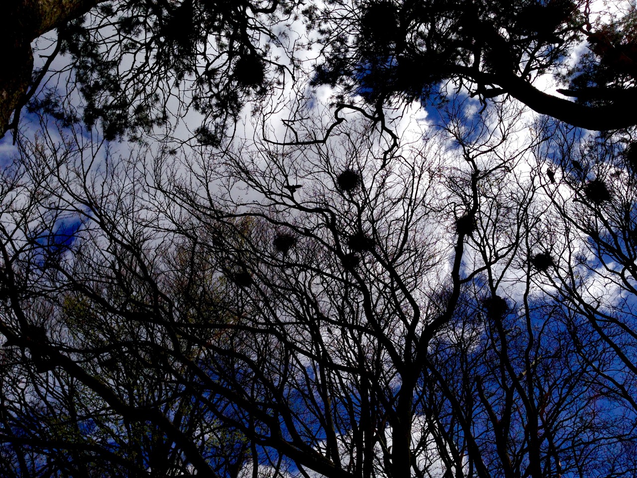
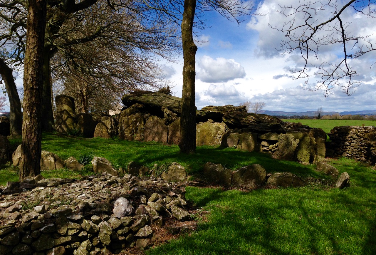
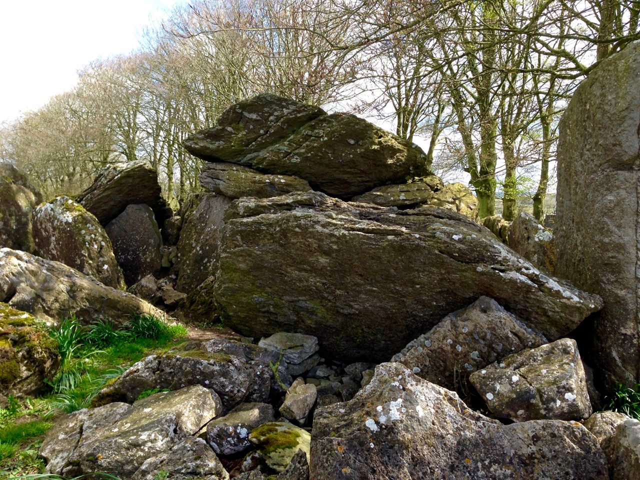
My strongest memory of our visit to Labacallee wedge tomb, Co Cork, earlier this summer was the rookery above it. Our presence seemed to make this multitude of large black birds restless: there was a constant movement over our heads – a mixing up of flapping feathers, wind in the still bare branches and screeching protests. These are the unpaid guardians of this monument, apparently the largest of its kind in Ireland, with a long documented history and a wealth of folklore.
Labacallee today: it must once have been an impressive and dominant feature on an open landscape. Now it has been closed in by fields, trees and a byroad running north out of Fermoy. In the foreground is a cairn, possibly made in relatively modern times from material excavated from the monument
Finola has written about wedge tombs. She calls them The Last of the Megaliths: court-tombs, portal-tombs and passage-tombs are slightly earlier constructions, built before c2000 BC, while wedge tombs date from some 500 years after this. According to the Archaeological Inventory of County Cork Volume 1 (Stationery Office Dublin 1992) …The more numerous and widespread wedge-tombs are relatively small and simple constructions, so called because of an increase in height and width from the chamber rear to the entrance front. They generally face in a south-westerly direction, an orientation they share with stone circles and stone rows…
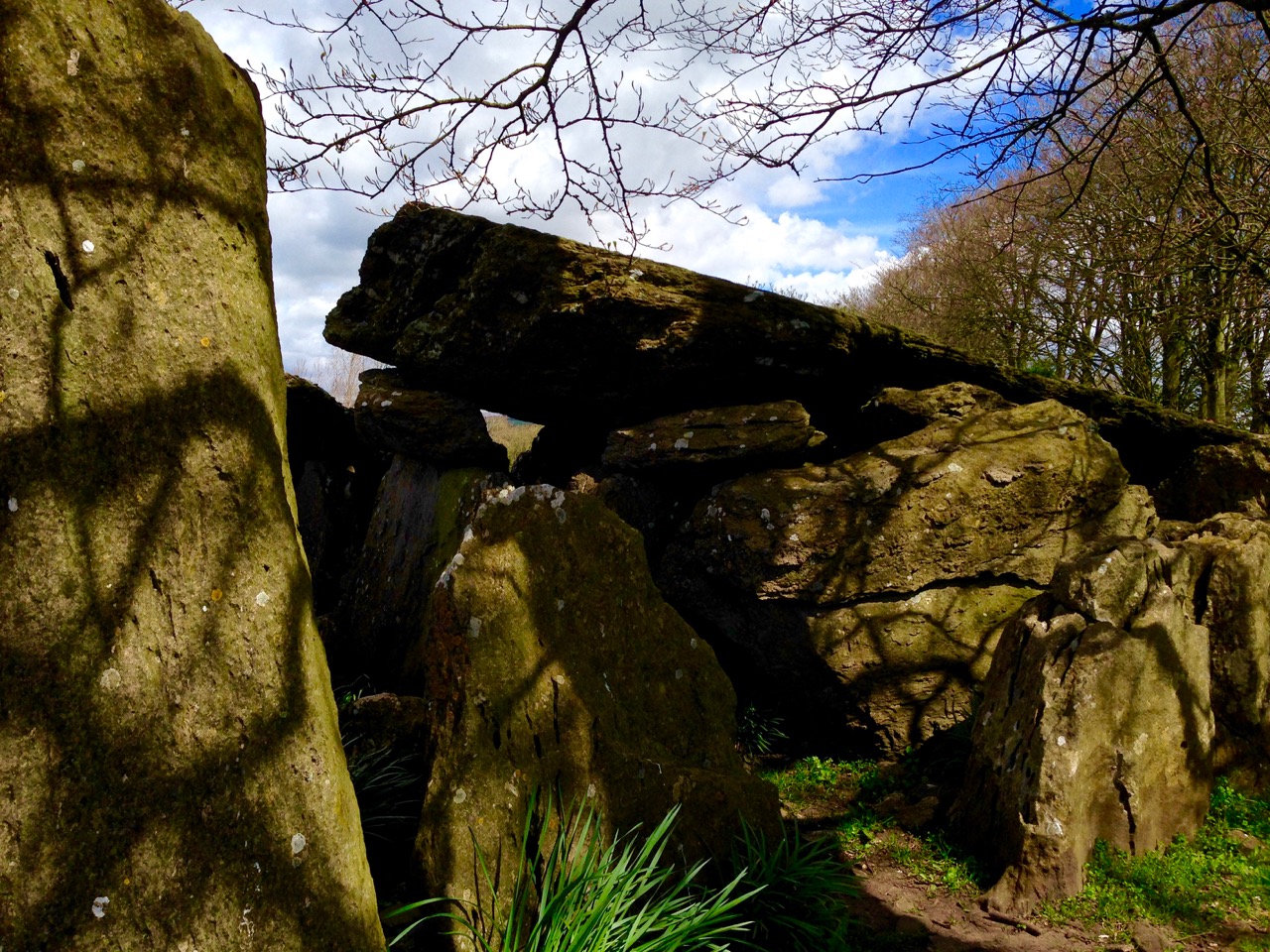
The east facing – and narrower – end of the wedge tomb
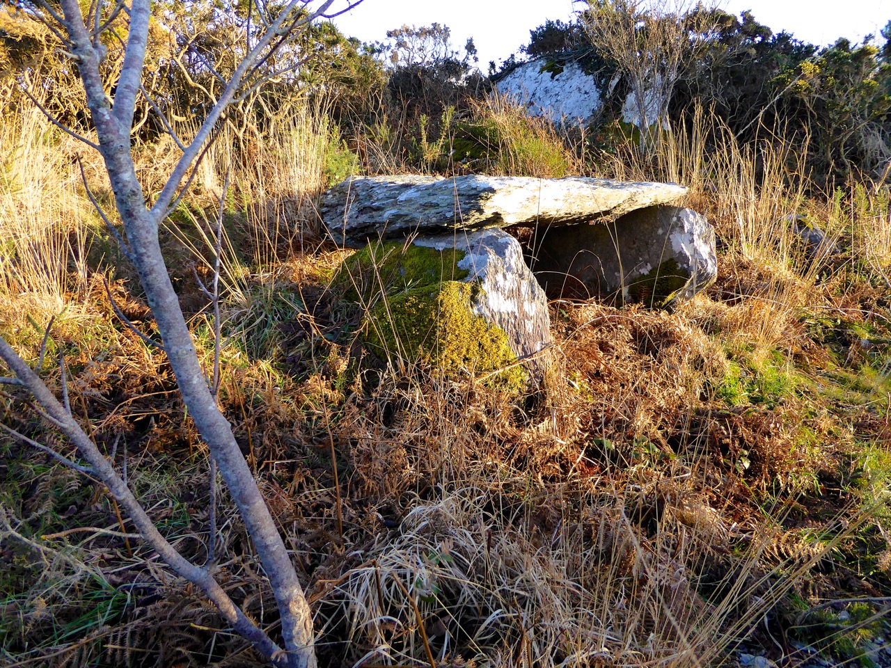
Labacallee is enormous, especially if you are only familiar with examples such as Altar, west of Goleen (itself sizeable) or our own more domesticated version at Kilbronogue, a neighbouring townland:
A more ‘human scale’ wedge tomb at Kilbronogue, West Cork: many thanks to Stephen Lynch, a near neighbour, for looking after this example and allowing us access
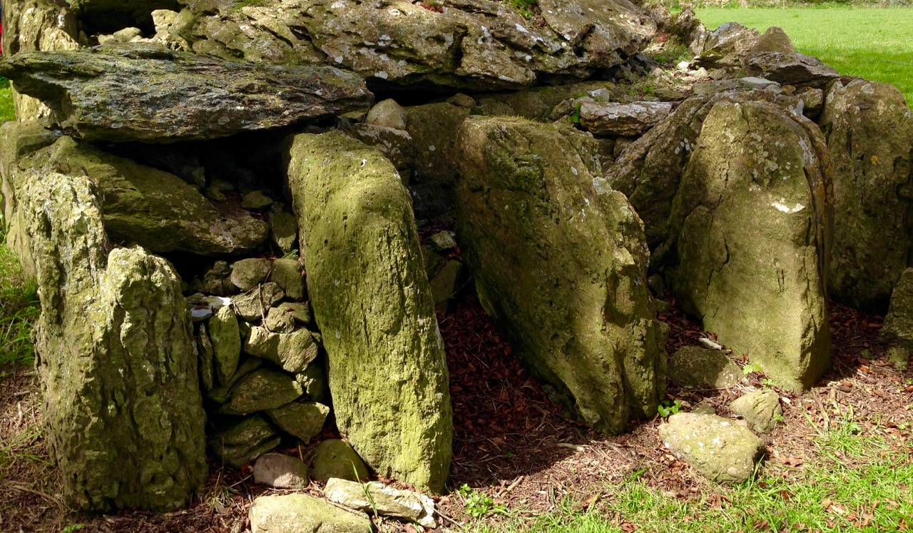
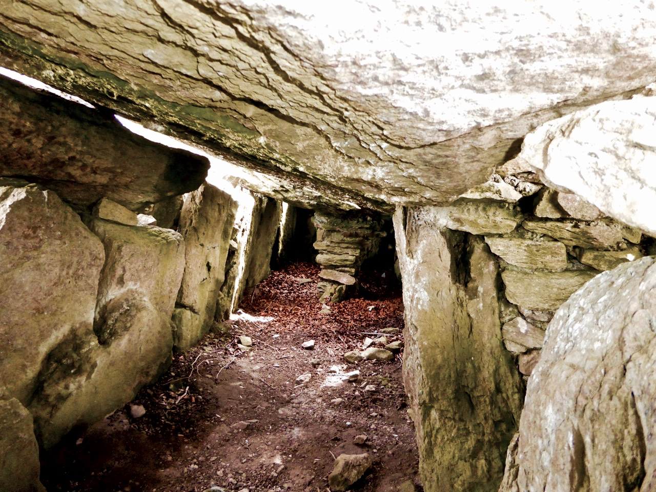
Labbacallee – the name seems to be from the Irish Leaba Caillighe – ‘the bed of the witch’ – measures some 14 metres by 8 metres overall. It has a series of upright stone ‘walls’ supporting three capstones. The largest of these measures 5 metres by 2.5 metres and is a metre in thickness: it must weigh at least 10 tons. These stones house three ‘chamber’ enclosures.
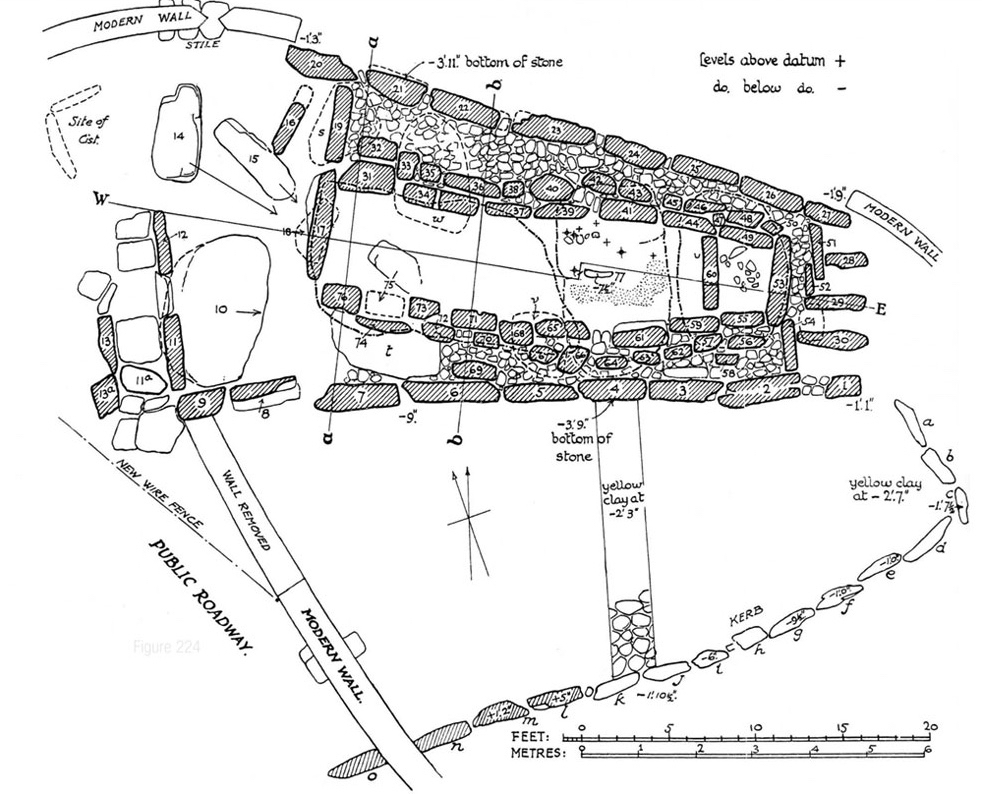
Plan of Labbacallee wedge tomb drawn following the excavation by H G Leask and Liam Price in 1934, from Proceedings of the Royal Irish Academy Volume 43
The tomb has been recognised as an important site in British and Irish archaeology over a long period. English antiquary John Aubrey, who lived from 1626 to 1697 (and who was incidentally described as “Shiftless, roving and magotie-headed…”) is recognised as one of the first serious recorders of historic sites. He was also a keen collector of folklore and, like me, felt that the stories that local people told about the monuments around them were valuable insights into perceived history.
John Aubrey and a drawing of Labbacalle he published in 1693. While you can see in the drawing the principle of a chamber constructed of upright stones and roofed with large slabs, there is very little resemblance in the drawing to the structure itself (which was anyway in a ruinous state in Aubrey’s lifetime). It has been suggested that Aubrey obtained the sketch – or a verbal description of the tomb – from a Mr Gethyng who lived close by it
A drawing from the1897 work The Dolmens of Ireland, their Distribution, Structural Characteristics, and Affinities in Other Countries; together with the folk-lore attaching to them and traditions of the Irish people by William Copeland Borlase 1848 -1899. This Cornish antiquary and politician spent part of his life in Ireland so it is likely that he did visit the tomb. Certainly the drawing is more true to life than Aubrey’s. After what has been described as ‘high living’ Borlase died in disgrace, having been involved in scandal and bankruptcy
Artistic interpretations of a subject: views of Labbacallee dating from 1827 (top), 1844 (below left) and 1845 (below right by George Wilkinson)
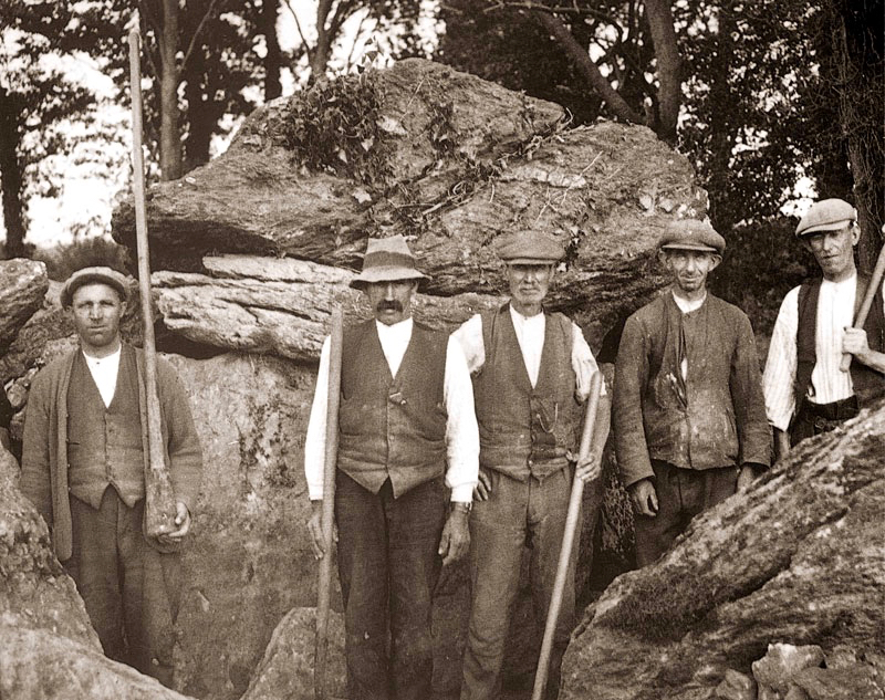
The first full scientific examination and excavation of the tomb was carried out in 1934 under the supervision of H G Leask, using workers paid one guinea per week as part of a government unemployment relief plan. According to the excavation report, at this time the smallest chamber was filled to the top with rubble, including earth, stones, ash and the bones of animals and humans. When these were cleared a skeleton of a woman was exposed, together with a bone pin which might have fastened a garment or shroud. The woman’s skull was missing but later found upright (as though on display?) in the large main chamber. One of the leg bones of the skeleton was deformed: this led to the speculation that her handicap may have set her apart in life, giving her a status that was either feared or revered: she might have been ‘marked out as a witch’.
Leask’s excavation team in 1934 (top) and (left) his drawing of the headless skeleton as found; (right) the separated skull of the ‘witch’
I am fascinated that ‘folk’ or oral traditions survive through generations, centuries and even millennia. In the case of Labbacallee, we know that the name existed back in Aubrey’s time – over three hundred years ago – and was undoubtedly well established by then. Could it be that the name – ‘bed of the witch (or hag)’ – was the persisting memory of the interment of an important person, perhaps a priestess or shaman, from very ancient times?
The Hag’s Bed – the main chamber in the monument, where the skull was found
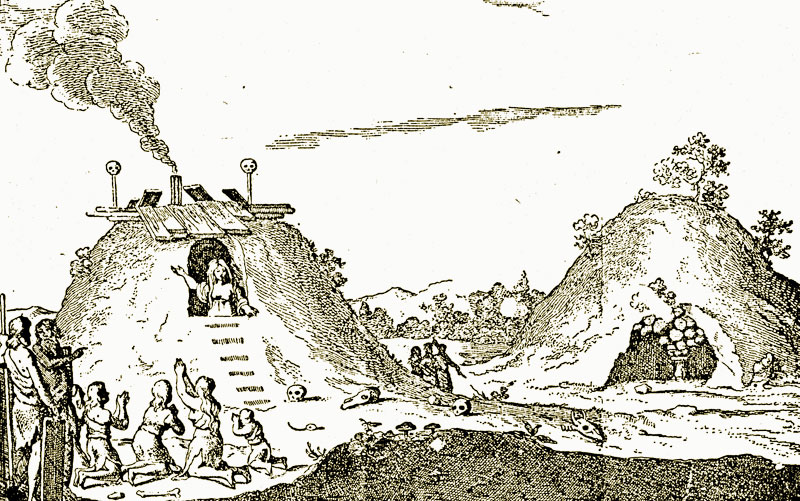
While the excavators were exploring Labbacallee they found evidence to suggest that the tomb (or part of it) had been an occupied dwelling at some point during its history. The notion that some historic and prehistoric monuments were (or are still) the dwelling places of the Old Ones, or The Other Crowd – supernatural beings possibly descended from ancient invaders of Ireland – or had in fact been used in some way by practitioners of magic – is not unknown. Borlase’s 1897 work on The Dolmens of Ireland… included this illustration (albeit from the Netherlands) of ‘A ‘White Woman’ (wise woman or witch?) prophesying from a dolmen-mound’. It’s not a big leap to the idea of a witch being buried in a wedge tomb.
Legends specific to a ‘hag’ of Labbacallee suggest that she was married to a druid, Mogh Ruith, who ‘had an eye’ for the hag’s sister. In a fit of jealously the hag chased the druid towards the River Funchion. He reached the water and started to cross it: the hag threw an enormous boulder which struck the druid, toppling him and pinning him down under the water. As far as we know, he’s there to this day!
Stories in stone: Labbacallee landscape
Another story specific to Labbacallee also involves a drowning – and a warning! This version is from theirishplace.com:
…Whatever the provenance and history of the remains found in the Labbacallee Wedge Tomb, there is no doubt that it is a site around which legends abound. One of the most pervasive legends tells that one day, very long ago, four local men went to the tomb in the middle of the night, with the aim of digging for the treasure that they had heard was buried there. As they started to dig, it is said that an enchanted cat appeared, fire bursting from its tail, terrifying the men, who were dazzled by the light emitting from it. Panicking, they ran screaming from the scene, and in the ensuing panic one fell into the nearby river (Funchion) and drowned. The remaining men lived to tell the tale, and their experience stood as a stark warning to others that they should never, under any circumstances, disturb the resting place of the long dead at this most mysterious of megalithic sites…
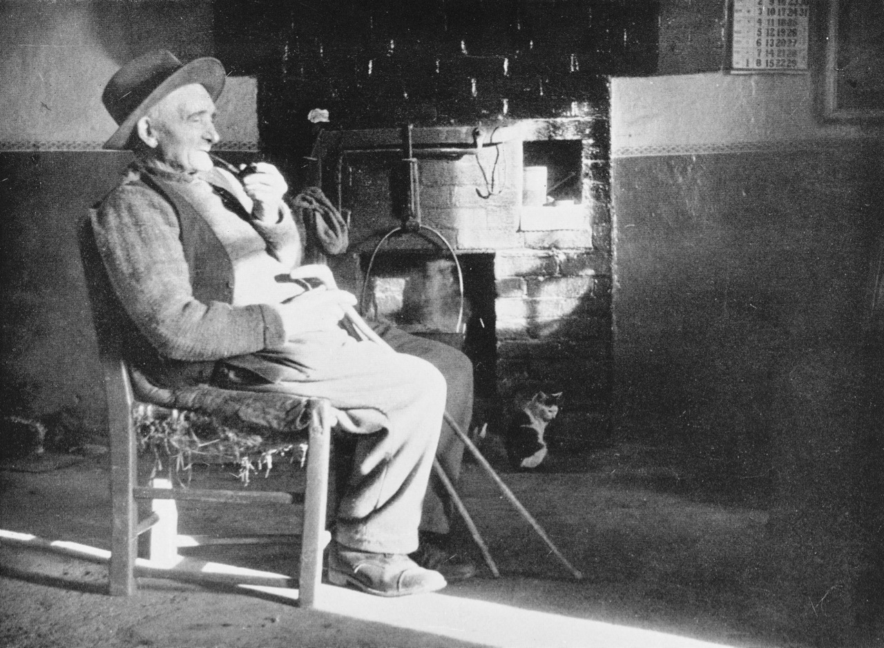
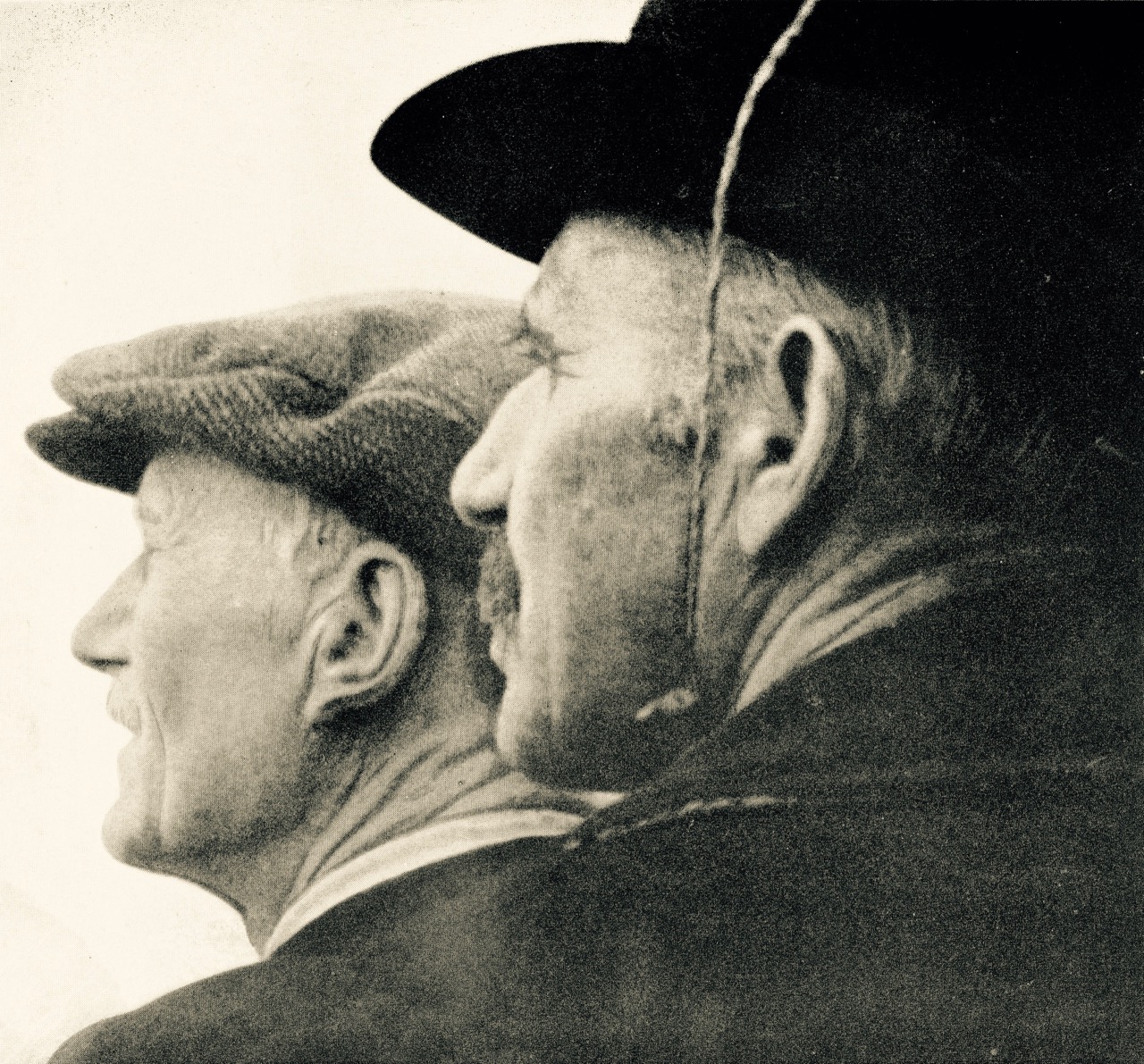
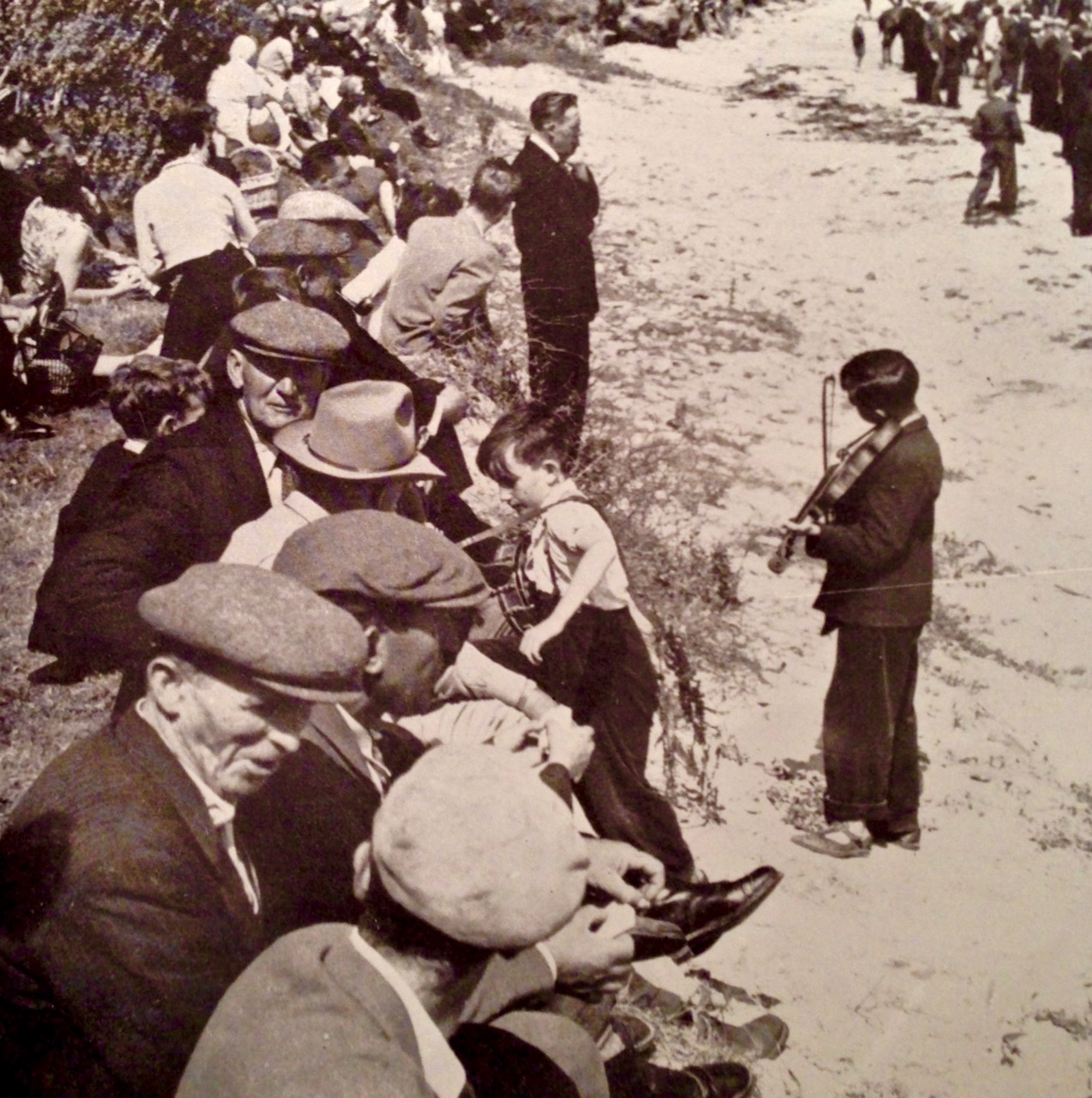
Two young musicians – from the collection of Tomás Ó Muircheartaigh, who documented life in rural Ireland between the 1930s and the 1950s. We do not know at what outdoor gathering this atmospheric picture was taken, but perhaps there is a polka or a slide being played there…
Way back in the last century (it was the nineteen seventies actually) I first came to Ireland in pursuit of traditional music. I found it a-plenty. At that time, the music of the Sliabh Luachra was very much in vogue: local sessions and Fleadh Ceols were full of polkas and slides…
Classic recordings of traditional music collected from the Sliabh Luachra during the sixties and seventies: The Star above the Garter is published by Claddagh, while the others are from the Topic Record catalogue
My post last week came to you from the City of Shrone, which is within this area, in the border country of Cork, Kerry and Limerick. The strong surviving music traditions here have an unmistakeable character – fast and lively. I was reminded of that tradition this week when I came to the wonderful Fiddle Fair in Baltimore and listened to Tony O’Connell from the Sliabh Luachra in recital with Brid Harper, a highly regarded Donegal fiddler. They are an excellent duo – here’s a little taster from that concert (Kerry Slides):
As an aspiring concertina player myself I was bowled over by Tony’s playing, especially of the quintessential Kerry slides. But what is a slide you might ask? And how do you tell a slide from a jig?
Saturday’s recital in Saint Matthew’s Church, Baltimore: Brid Harper and Tony O’Connell playing Kerry Slides
Here’s some help, extracted from discussion boards, specifically on the subject of slides and jigs:
…Uninitiated listeners and even some tune-book editors have mistaken slides as hornpipes, single jigs, polkas, or double jigs, since slides share various traits with each. Once you know a few, you realise they are distinct from any of those…
…Note that slides are peculiar to the Southwest of Ireland, and some are directly related to double jigs, single jigs, or hornpipes played elsewhere in Ireland. Musicians quite familiar with slides are generally unfamiliar with single jigs, and some otherwise respectable authorities on the slide have rashly pronounced that single jigs “are the same as slides.” We can have some sympathy with that by understanding that these musicians simply use the term “single jig” to mean “slide,” and are apparently unaware of the existence of the distinctive “single jig” rhythm in Irish music. Over the course of the 20th century the customary notation for slides shifted from 6/8 to 12/8, which I think is an improvement in accuracy…
Both these statements (from irishtune.info) tell us about the confusion between jigs and slides, but they don’t tell us exactly how you define either of them. Let’s try this, from the same source, regarding slides:
…The tempo is rather quick, often in the 150 bpm range, if you were to count each heavy-light pair as a beat. But in practice each beat of a slide (counting around 75 bpm now) gets two pulses, which is either a heavy-light pair (very close to an accurate “quarter note, eighth note” distribution) or a quite even triplet – not a jig pattern. Thus if all four group-halves in a bar were triplets – which is uncommon – you’d have a twelve-note bar. The ratio of heavy-light pairs to triplets in a slide is slightly in favour of the pairs, which again clearly distinguishes them from double jigs. Most slides break the pattern once or twice in a tune by delaying the strong note for a bar’s second group until that group’s second half, creating a cross-rhythm with respect to the foot taps. Other unique characteristics of slides are not necessary additional information for identifying them – only for playing them…!
I’ve puzzled over this (and other advice) for some time: I sort of understand it, but I think it’s impossible to describe a rhythm in words… However, I was pleased to find this mnemonic for slides by the poet Ciaran Carson – it says it all:
“blah dithery dump a doodle scattery idle fortunoodle”
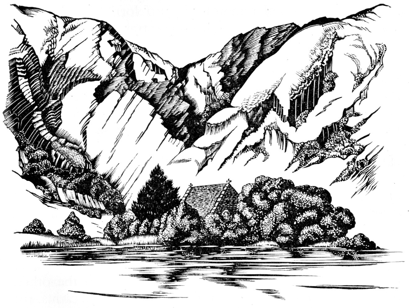
An evocative engraving of Gougane Barra, in the Sliabh Luachra, by artist and writer Robert Gibbings, taken from Lovely is the Lee, J M Dent, 1945
How about polkas and reels? Polkas, in particular, are popular in the Sliabh Luachra tradition:
…The polka is one of the most popular traditional folk dances in Ireland, particularly in Sliabh Luachra. Many of the figures of Irish set dances are danced to polkas. Introduced to Ireland in the late 19th century, there are today hundreds of Irish polka tunes, which are most frequently played on the fiddle or button accordion. The Irish polka is dance music form in 2/4, typically 32 bars in length and subdivided into four parts, each 8 bars in length and played AABB.Irish polkas are typically played fast, at over 130 bpm, usually with an off-beat accent… (Also from irishtune.info)
Reels are probably the most popular tune type within the Irish traditional dance music tradition:
…Reel music is notated in simple meter, either as 2/2 or 4/4. All reels have the same structure, consisting largely of quaver (eighth note) movement with an accent on the first and third beats of the bar…
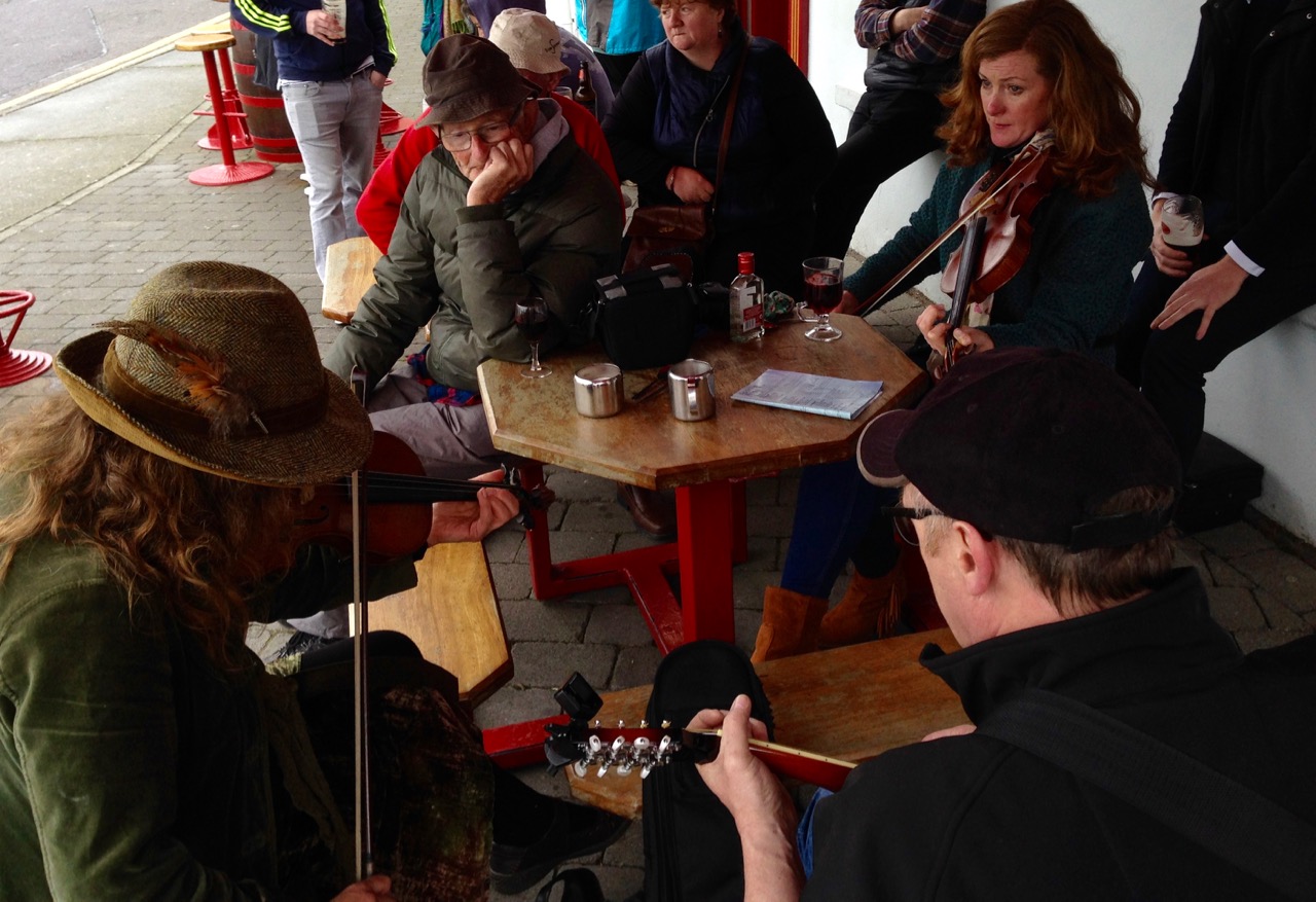
At the Baltimore Fiddle Fair, informal sessions are essential interludes
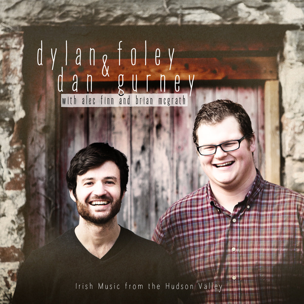
Definitions are all very well and these can only be generalisations. In the end it’s what is being played – and what you hear – that counts. For me, the music in Ireland is like history: it’s built into the landscape and the psyche. Irish people are survivors and have travelled all over the world and back. So has the music! This was emphasised today when we had another excellent recital in the church by Dylan Foley and Dan Gurney, fiddle and accordion.
They both come from the Southern Catskill Mountains in New York State. Much of the Irish music they play was learnt directly from Father Charlie Coen who emigrated to the United States from the village of Woodford in County Galway in 1955, bringing the music traditions from East Galway with him. Here’s an excellent example of the music travelling across the world and back again: Fr Coen played The Moving Cloud reel on his concertina, but his instrument had some buttons missing so he adapted it, and the adapted tune is what we heard Foley and Gurney playing in the church today. Listen first to another Fiddle Fair maestro, Noel Hill playing the reel from his 1988 album The Irish Concertina:
Now the same reel which has travelled from Ireland to Baltimore via the Catskill Mountains:
I hope you can hear those ‘odd’ notes! But there’s nothing so right or so wrong in Irish music: the grand finale for us today was a memorable concert with French Canadian fiddler Pierre Schryer, Donegal box player Dermot Byrne and Australian born guitarist Steve Cooney. They played music with an Irish bias but harvested from many traditions. It left us breathless…
Welcome to the UCD Library Cultural Heritage Collections blog. Discover and explore the historical treasures housed within our Archives, Special Collections, National Folklore Collection and Digital Library