Into the Kingdom

To the Skelligs

The Kingdom? No, we didn’t go to Britain – we went to Kerry. It’s always been called the Kingdom, possibly based on ancient Irish precedents, although other theories abound. Many people think it’s because of the sheer magnificence of the scenery, and I wouldn’t disagree.

Ballinskelligs Bay

Ballinskelligs Bay. The first photograph is also Ballinskelligs Bay, with a glimpse of the famous Skelligs Islands in the background – subject of a future post, we hope!

Our journey took us on the Ring of Kerry, along the south side of the Iveragh Peninsula, by the sea. This is prime tourist territory – bus after bus passed us and every lay-by was thronged with camera-wielding tourists, including us. We came back through the middle of the peninsula, through deep valleys and high mountain passes.

To Ballaghbeama

Not for the tour busses!

These are not roads that busses can manoeuvre through, so we had it mostly to ourselves, the locals, and a few tourists armed with small cars and good maps. I love this Iveragh backcountry. It’s where I spent my student days, conducting my research. I even recognised the place where I crashed my Honda 50 into a bog.

Ballaghasheen Pass

Although it seems totally mountainous, vast sheltered valleys occupy some of the hinterland of the Iveragh Peninsula  

We visited two stone forts, the mighty Staigue and the lesser-known Loher, and of course some rock art. Staigue Fort is generally reckoned to be Iron Age (about 250AD), while Loher, although very similar, was built later, around the 9th Century.

Staigue Interior and outlook

Loher Stone Fort
Staigue Fort (upper), at the head of a long valley, commands views to the sea. Loher is also strategically sited with extensive views all around.

We toured Daniel O’Connell’s House at Derrynane and took the Nature Trail walk along the dunes, using the app developed by local man Vincent Hyland.

Shoreline walk

Wild flowers a-plenty on the dunes at Derrynane. Top: Sea Pinks and Sea Sandwort. Bottom: Pyramidal Orchid and Kidney Vetch

We searched in vain for the holy well devoted to Saint Crohane, patron saint of Caherdaniel – we’ll have to go back with Amanda to help us find it.

Across to the Beara

We didn’t find St Crohane’s well but when we finished our search, in twilight, this is what was waiting for us. The mountain range in the background is the Beara Peninsula in Cork

In fact, the primary purpose of our trip was to re-connect with cousins that I haven’t seen for about 45 years. The last time I saw Annie and her siblings they were kids, and we were all piled on to a donkey and cart in a vain attempt to get from Lamb’s Head to Staigue Fort. It’s a long story, but suffice it to say that the donkey came out the winner. Most of the family still live around Caherdaniel, in jaw- dropping surroundings, and we were accommodated and hosted with true Kerry hospitality.

The view from Annie's

Top: The view from Annie’s house, across to Lamb’s Head where the family grew up

Along the way we saw a house shaped like a ship (Robert has more – much more – about this!), had our first experience of bottle-feeding a lamb, and we watched Rex the sheepdog gently herd a flock of chickens into their pen for the night. We visited my cousin Betty’s grave – she died a few months ago, the heart of the family, much mourned. It was, we hope, the first of many visits, back and forth.

Abbey Island

Abbey Island, Betty’s last resting place, must be one of Ireland’s most beautiful graveyards. To access it, you must walk across the sand and keep an eye out for high tides. The original monastic site was founded by St Finian in the sixth Century, although the ruined church, Ahamore Abbey, probably dates from the 10th Century.

This post is to give you a flavour for our neighbouring county and to show you why it is justly famous for its history and archaeology, but most of all for what is surely some of the most spectacular scenery in the world.

Lamb's Head to Scariff and Deenish IslandsScarrif and Deenish are the two islands out from Derrynane Bay. Uninhabited for 40 years, they are the site of salmon farms now. We walked down Lamb’s Head to get a better view of them.

Tiny green fields

As in West Cork, everywhere in Kerry you can see the traces of tiny settlements. Abandoned long ago, possibly after the famine, each field may have provided enough potatoes for one family. Now only the sheep graze peacefully.

Ballaghbeama Gap

We headed home through the Ballaghbeama Gap. On the south side is Ireland’s greatest concentration of prehistoric rock art. We wrote about this in our post Derrynablaha Expedition.

Down from Ballaghbeama

Heading down towards Derrynablaha and home

Derrynane Sunset

It was hard to leave Derrynane!

Anomalies

The cairn

What’s an archaeological anomaly? When the National Monuments Survey was being undertaken, some stone structures didn’t quite fit the description of a particular class of monument. They may have been ancient – but how ancient, and what exactly were they? The term chosen for such mysterious piles  was ‘anomalous stone group’. Here’s the definition: A group of stones, usually standing, which cannot be classified as any other known archaeological monument type on present evidence. They may be all that remains or is visible of a partially destroyed or obscured archaeological monument which may date to any period from prehistory onwards.

cupmarked rocks?

Just a leaning rock?

But it’s not the only term used for uncertain monuments: enclosure is a vague term that can mean a multitude of things, and an ‘unclassified cairn‘ can be defined simply as a heap or pile of stones. In the last few months our explorations of the Sheep’s Head have turned up several anomalies. The only thing they all have in common is their spectacular siting, leading to an ultra-rewarding field trip.

Heading towards the cairn

Hiking to the cairn

Perhaps the most magnificently situated of all is the unclassified cairn on the mountain ridge above Kilcrohane. It’s right on the way-marked Sheep’s Head Way, so it’s easy to find. While it’s described as a cairn in the National Monuments inventory, it could be as humble an object as a turf storage platform or as wonderful as a passage grave. We’ve been to it several times and always puzzled over it, but on our last visit we were alerted to a new element by Amanda and Peter.

Amanda investigates

The ‘new element’ – you have to really look!

A couple of stones had shifted, possibly in storms, and we could now delve deeper into the pile of rocks and see that one of them had a large circular opening in it. Very strange – I had never seen anything like it – and very intriguing.

Curious ‘holed stone’ at the bottom of the cairn

We noted that the highest point on Cape Clear was visible across the water, the hill on which a ‘real’ passage grave sits. Only excavation is likely to reveal the exact nature of this anomaly.

What's the orientation?

This one is called an ‘anomalous stone group’

Not too far away, in the same townland but on lower ground, is an anomalous stone group. This is a strange one indeed because half of it looks for all the world like a stone circle – identical to the numerous recumbent or axial circles that dot West Cork. The other half? It’s the rock face that the stones obviously came from.

Is it a stone circe?

Could swear that’s a classic recumbent, but where’s the other half of the circle?

It’s like a work in progress. If it is a stone circle, the builders decided that half a one would do the job just fine. Indeed the owner of the land has noted several significant  sunset alignments.

possible alignments

There seem to be several alignments – this one to the Beara Peninsula

But when I asked for comments on an archaeological social network site the general consensus seemed to be that it was unlikely to be a stone circle, since the stone face obscured half the horizon. But that same stone face would have provided shelter, so the speculation in the discussion centred on this being a hut site, with only some of the stones of the outside wall remaining.

radial cairn?

This area of rough ground to the right of Robert, Peter and Amanda is labelled an ‘Enclosure’

The third site we’ve explored is described as an enclosure. The description of the site states: A circular area (diam. 10.5m) is defined by the remains of a stone wall (T 1.3m; H 0.5m) displaying traces of an inner and outer row of large stones with a fill of smaller stones. A stone slab (H 1.15m; L 0.5m; T 0.4m) narrowing as it rises stands on the external perimeter at E. There is also a standing stone a few meters to the south.

inner row?

Difficult to make out what’s here, but it seems like there’s a lot going on

This could be a radial cairn – take a look at the one at Kealkill to see what we mean. But equally, the description hints, it may have to do with field clearance. It’s almost impossible to tell a lot from the general jumble of stones and the furze and brambles that grow all over the site. Once again, however, we were rewarded with panoramic views to the Beara Peninsula. Another one where only an excavation will reveal the truth.

View east from the enclosure

And these views of the farms to the east, lit by a shaft of slanting sun

Finally, we trekked out on the Lighthouse Loop Walk at the very end of the peninsula in search of possible cupmarks, discovered by Peter and Amanda’s son.

Lighthouse trail, looking back

On the lighthouse loop trail, looking back

The cupmarks turned out, we’re pretty sure, to be natural solution pits. There were lots of them, of varying sizes, and some could only be viewed by lying on your back.

The pitted boulders

The ‘cupmarks’ are on the underside of the leaning rock

Instructive, though, as we have certainly seen cupmarked stones that don’t look a whole lot different than these ones – there’s a type of shaley sandstone in West Cork that laminates in a very similar manner when carved.

Solution pits

pits all aroundSolution pits – and modern graffiti 

In West Cork, monuments that don’t fit into satisfying categories abound – and it’s just as much fun exploring them as it is the ‘normal’ type!

tough to take

This kind of field trip is tough to take!

Mizen Mud: Recipe for a February Exploration Day

Muddy Boots

It’s been a wet, wet winter, but when the sun shines in February (which it does, honestly!), we are out exploring. This particular day our companions were Jessie, Brandon, Amanda and Peter and our accompaniment was MUD, and lots of it.

Explore Group

Amanda took the photo of the group, and the one of my muddy boots

We had goals – Amanda was after some elusive holy wells and Robert wanted to find the pirate steps at Canty’s Cove for his talk on William Hull and the Leamcon Pirates’ Nest, part of the Ballydehob spring lecture series, ’Talks at the Vaults.’ Jessie is a professional tour guide, wanting to learn more about the Mizen. Finally, I wanted us to swing by Dunmanus Castle so I could check out a few construction details.

Dunmanus Castle and bridge

Dunmanus Castle on its knoll, surrounded by water

You don’t actually need goals like this to go out exploring, but it helps. It gets you into places you wouldn’t normally go, down tiny boreens, into farmyards and across fields. You end up knocking on doors and meeting people who know all about the well, or the old stones, or the legends of the place, or who owns what field and whether he minds people tramping through it. On this occasion we met, for the first time, the near-legendary Pat McCarthy, one of the writers of Northside of the Mizen, and a huge authority on this area. We’ve promised ourselves a return visit with him as we weren’t able to stay long enough for a good talk.

Budds

The best way to start a day like this is with excellent coffee, in Budds of Ballydehob, where we assembled with our map to plot our course. It was off then to Toormore and the Altar wedge tomb. On this occasion we weren’t actually after the wedge tomb (although I can never resist a photo of it) but the little holy well across the road.

Altar Wedge Tombe

Our next stop was Dunmanus, to take a good walk around the castle with the camera, looking for details I had missed on previous visits.

Dunmanus Castle ground floor entrance details: The bar-hole for barring the door once inside; the spud stone and the hanging eye. The hollows are for the pole that the door swings on

And then on to Canty’s Cove. You can read Robert’s post, Canty, for more about this place and its association with Canty the Pirate. Finding the steps wasn’t easy and it was a big thrill when we finally figured out where to look.

from Canty's House

This is the inlet with the pirate steps. Photographing them involved hanging over the edge with someone holding on to your ankles

Pirate Steps

How would you like to climb up these with a keg on your back?

By then we were starving – this exploring is hungry work – so we repaired to O’Sullivan’s of Crookhaven for one of their famous crab sandwiches. Even at that early date the sunshine was so inviting that people were sitting outside with their sandwiches and their pints.

water pump at Crookhaven

Crookhaven Pier

From Crookhaven it’s a quick trip to Lissagriffin, where there’s a medieval church and a bullaun stone doing double duty as a holy well/wart well. The church has a panoramic view over the salt marshes behind Barley Cove Beach as well as interesting architectural features.

Lissagriffin Doorway

Our next holy well was right by the side of the road a couple of miles further east – labelled so we couldn’t mistake it.

Callorus Oughter

Amanda inspects Tobareenvohir – or Tobairín an Bhóthar, the Little Well of the Road

The final one was harder to find and necessitated negotiations of some seriously muddy fields. Tobairín Brón (Little Well of Brone) was in the general vicinity of where we ended up, along with a small monastic site – all very brambly and hard to decipher. But what a place – a view clear out to the Fastnet Rock, with Knockaphuca looming behind us. Cnoc an Phúca means the Hill of the Mischievous Spirit – it’s been tamed, presumably, by the large cross erected on its peak.

Monastic site

Knockaphuca

Fastnet Rock

Read Amanda’s post for her take on the four wells we visited that day.

By then the sun, so warming earlier in the day, had been overtaken by high cirrus clouds, and we were donning jackets and gloves and remembering that it was only February after all. As if to make up for its lack of warmth, it treated us to a magnificent solar halo (I’ve always called them sun dogs)  as we made our way back to the cars.

Sun dog

We were never much more than 30 kms (or about 40 minutes) from home but in that distance we managed to see heritage sites dating from the bronze age through the medieval period up to the recent past, surrounded all the time by the magnificent scenery of the Mizen. You can do this anywhere in Ireland. Using the Historic Environment Viewer of the National Monuments Service, define the area you want to explore, pick your fancy (ring forts? medieval churches? cross slabs? megalithic tombs? castles? rock art?), and off you go.

Peter and Amanda in a holy well

A holy well looks back at Amanda and Peter

Now, if you’ll excuse me, I’m off to buy some wellies…

Mosaics and Maharajas, Part 2

East Window

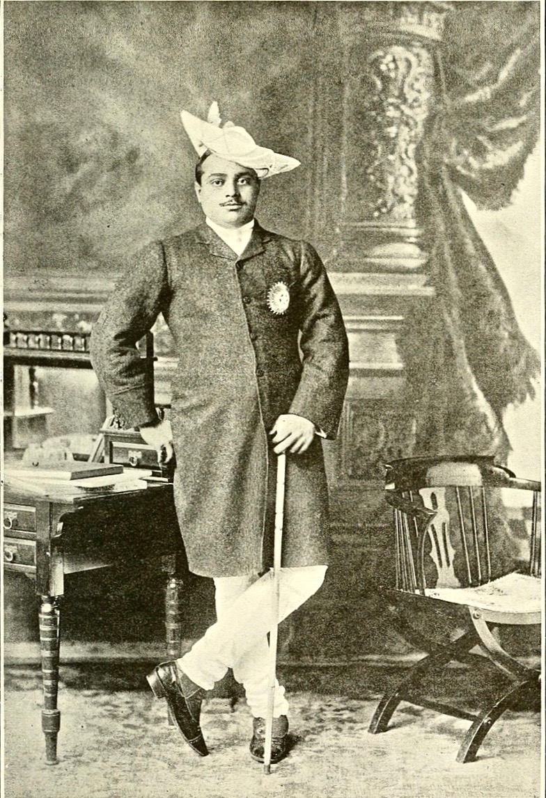
The more I look into the Church of the Ascension in Timoleague the more fascinating it becomes. Last week I concentrated on the mosaics and the story of the Maharaja, but what I failed to say is that the mosaic tiles were made by Minton, as were the encaustic tiles on the floor. Minton is known for its bone china but in fact it was also was the leading producer of British ceramic tiles during the 19th century.

Encaustic Tiles

The encaustic floor tiles as well as all the mosaic tiles were made by Minton

The windows were also produced by the most famous British stained glass artists of their day, as we shall see. Taken as a whole then, the architecture and decoration of this singular church leads us directly to Augustus Pugin, one of the giants of the Victorian Age, and locates it in the highest echelons of the Gothic Revival Movement. This hidden gem is even more of a jewel than I suspected!

Pugin

Who was Augustus Pugin? Born in 1812, son of a French emigré draughtsman and an English mother, Pugin trained in his father’s workshop, becoming proficient in design and drafting by aged 9. Conversion to Catholicism and a visit to Nuremberg in Germany convinced him that the greatest expression of church architecture was High Gothic and he set about challenging, and ultimately revolutionising, the prevailing design norms of the Victorian period. He was incredibly prolific and influential, such that today when we think about Victorian architecture and gothic revival, we are really thinking about the work of Augustus Pugin – even though he died in 1852 at the early age of 40.

The signature of the Warrington Stained Glass Company on the East Window

Pugin designed several churches in Ireland (mostly Catholic), especially in Wexford, where you can follow the ‘Pugin Trail’. (I don’t know who wrote the Wexford Pugin Trail brochure, but it is one of the best explanations of his style and influence that I have read.) While he did NOT design the Church of the Ascension, his influence is everywhere in evidence, along with the use of his favourite suppliers – Minton for the mosaics and tilework and Warrington, Lavers and Westlake, and Mayer for the windows.

Church interior looking east

Hallmarks of gothic revival: a beautiful hammer-beam ceiling, tall pointed windows with simple Y tracery, everything to lead the eye upwards

The real art of making stained glass in the medieval style had been lost and during the 18th century colour was mostly painted directly on the glass using an enamel technique. But part of the gothic revival ethic was to base manufacturing technology as closely as possible on the original so there was also a re-discovering of real stained glass processes where the colour was fired directly into the material and sections of glass were separated by lead. This art was revived in the 19th century by artists and craftspeople who studied medieval glass and learned through trial and error how to make it again.

The Presentation

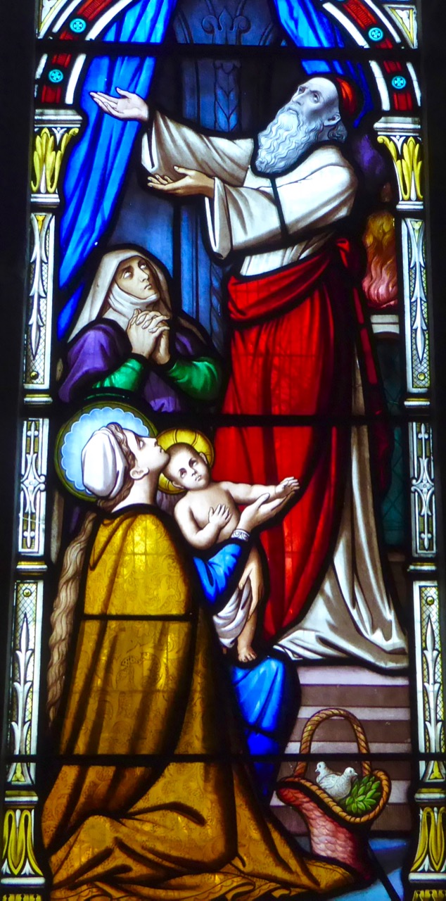
The Presentation, East Window

Let’s start with the East Window, the work of Warrington. William Warrington was one of the leading stained glass artists of his day. Like Pugin, he was a student of the gothic style and he strove to reproduce glass work as close as possible to medieval models. He had trained with his father as a painter of armorial shields, an influence that can be seen in his designs. He wrote a book in 1848 on The History of Stained Glass, but fell afoul of the group called the Cambridge Camden Society (or CCS) who had set themselves up as the arbiters of taste in all things related to church architecture. Partly this was the outcome of class prejudice: the CCS, all university educated men, did not believe that a “mere artisan” should be allowed to have an opinion of what they saw as their own exclusive preserve.

supplicants

Detail from The Raising of Dorcas, East Window

By any standards, this is a beautifully executed window. According to the Wikipedia article, Warrington’s figurative painting strives towards the Medieval in its forms, which are somewhat elongated and elegant, with simply-painted drapery falling in deep folds in such a way that line and movement is emphasised in the pictorial composition. His painting of the details, particularly of faces, is both masterly and exquisite.

Raising Dorcas

The Raising of Dorcas, East Window. In this story, from the Acts of the Apostles, Peter prays over the dead body of Dorcas, who returns to life

This is all clearly visible in the East Window, a masterful set of three lights depicting the Crucifixion in the centre, Raising Dorcas on the left and the Presentation in the Temple on the right. Note the use of heraldic motifs above the main panels, and the tall medieval-style spires of foliage, all typical of Warrington glass.

East Window heraldic

For some reason, this was all too much for the Bishop of Cloyne when he came to consecrate the new chancel in 1861. Cloyne Cathedral itself was a true medieval building but much simpler in its interior decoration. The Bishop obviously had less sympathy with this new style of highly decorated church interiors and objected in particular to the East window, which he viewed as similar to the ‘graven images’ popular in the Catholic churches.

On the cross

He refused to conduct the consecration unless the window was covered in a cloth. The cloth, apparently stayed up a long time, and when it came down the window continued to attract opprobrium – it was even attacked and broken on at least one occasion! It’s hard to understand now how such a beautiful piece of devotional art could have inspired such an over-the-top reaction.

Jesus Walking on the Sea

The Sermon on the Mount by Lavers and Westlake

Three sets of windows in the nave are by Lavers and Westlake, yet another of the London-based stained glass firms that responded to the new demand for gothic-revival glass windows in 19th century Britain. Nathaniel Westlake was another scholar of stained glass, publishing a four volume work, A History of Design in Painted Glass, and also a decorative painter of wall and ceiling panels. He was considered one of the leading exponents of stained glass art with a style considered to be Pre-Raphaelite. He worked with William Burges for a while – the one who designed every aspect of St Fin Barre’s Cathedral in Cork – who recommended him to the firm of Lavers and Barraud. In 1868 he became their chief designer and was responsible for much of the success of the firm, which captured a large share of the booming stained glass industry. Unlike Warrington, however, Westlake did not clash with the CCS, probably because his partner, Lavers, was a member of that society.

Loaves and Fishes detail

A detail from the Lavers and Westlake Loaves and Fishes window showing Westlake’s Pre-Raphaelite tendencies

The three windows by Lavers and Westlake are in the nave on the north and south walls. Those on the north wall depicts the Miracle of the Loaves and Fishes and the Sermon on the Mount. That on the south wall is of Jesus Walking on the Water.

Loaves and Fishes Detail

Jesus Walking on the SeaAbove, detail from the Loaves and Fishes. Below, Jesus Walking on the Water

The final window on the south wall is by the firm of Mayer and the subject is The Good Centurion. Franz Mayer and Co was possibly the busiest stained glass company of all and are actually still in business under the name Mayer of Munich. The founder, Franz Mayer, started a company dedicated to “…a combination of fine arts, architecture, sculpture and painting…”. This firm was officially recognised by the Vatican so it was very popular with Catholic churches and there are many examples of Mayer windows throughout Ireland. In 1865 the firm opened a London branch, which supplied this window.

The Good Centurion

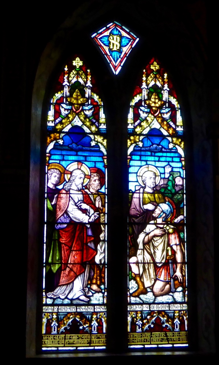
The Good Centurion, a window by Mayer of Munich and London

There are three more windows in the south transept, these ones by the firm of Clayton and Bell. They are very fine indeed and I particularly like the east and west window pair which depict, apparently, Life and Death, for their wonderful luminous colours.

Clayton and Bell windows, detail 

There are several more noteworthy features of this fine little church (the pulpit, the carved wooden furniture) but I think I will leave it at that for now. I’ve learned a lot about the Gothic Revival Movement through this exercise, and about some of its chief practitioners. I’ve been struck, as the reader might be, at how British (rather than Irish) the influences are in this church, but that of course was very much a function of the times. At some point I will write about the enormous Catholic church that dominates the village, with a view to showing how the great era of Catholic church building in Ireland finally led to an emphasis on Irish architecture and Irish artisans. For a very brief word on that, you can read my post A Tale of Four Churches.

Timoleague Three Churches

Timoleague. On the left are the ruins of the medieval friary, the Catholic Church dominates the hilltop, and the Church of the Ascension is behind the green building on the far right

And as for Augustus Wellby Northmore Pugin – you can learn more about this complex genius through the BBC Program Pugin: God’s Own Architect, available on YouTube.

Mosaics and Maharajas, Part 1

This week when we were passing though Timoleague I had a fancy to see inside the Church of the Ascension as I had heard it was ‘worth a look’.  Understatement of the century! What we saw was astonishing, beautiful, and overflowing with history and stories.

The key is kept at the Post Office on the main street – just ask

This Church of Ireland building is typical of the simple gothic revival style favoured by the funders – the Board of First Fruits. (Read more about this almost-forgotten organisation in a post from the always excellent Irish Aesthete.) Built from the ruins of an earlier (probably medieval) church it was consecrated in 1811 but enlarged later in the 19th century. The pointed-arch windows and the square tower with louvre vents are unremarkable features on the exterior, but open the door and step inside and you enter another world.

The mosaics are the most obvious (although by no means the only) glory of this church. Designed to commemorate members of the Travers family (yes, the same Travers whose memorials dot the walls of St Fin Barre’s) they cover the entire interior of the church, apart from the hammer-beam ceiling in the nave. They incorporate motifs in several traditions – Christian, Jewish and Islamic.

Above the west doorway is the Ascension scene – the apostles are rather conventional but I love their colourful robes and the flower borders. Below them is an angel font, similar to a pair in Tralee Cathedral, made of Carrera marble, with yet more mosaic detail.

Members of the Travers family are named in mosaic around the walls – Robert Valentine Travers of the Munster Fusiliers was only 22 when he fell at Gallipoli.

In the chancel, above the marble altar, the ceiling is covered in mosaic, as are the walls, some of which have been gold-leafed. The richness of the detail and the vision that dictated such a glorious conjunction of imagery and colour is jaw-dropping, and mark this little provincial church as part of the influential Oxford Movement of the Victorian era that aimed to return ornamentation and beauty to spaces of worship.

This is the great High Church and Low Church debate. A group called the Cambridge Camden Society promoted a return to gothic architecture: the classical style was seen as pagan, while the great gothic cathedrals of Europe represented the apex of Christian architecture. (More about this in the next post, which will concentrate on the stained glass.)

Installing mosaic is a time-consuming and expensive process – this one involved importing artisans from Italy and the parishioners eventually received help from an unexpected quarter. The final series of installations was paid for by an Indian Maharaja!

Madhav Rao Scindia was the Maharaja of Gwalior. He was wealthy and looking for places to  spend his money. What, you don’t believe that? Just read this story about the fabulous and secret treasure chambers of Gwalior. No – in fact, he was highly-educated ruler who did much to modernise his state but he was only 9 years old when he inherited the title.

The Maharaja in his prime

The British appointed as his surgeon and tutor an Irish doctor from Timoleague – Dr Martin Crofts. A long friendship grew, based on mutual respect (and shared tiger-hunting expeditions) and it is said that Crofts saved the life of the Maharaja’s son. 

Leaving for the Hunt at Gwalior by Edwin Lord Weeks

When Crofts died suddenly in 1915, after only a year of retirement, and was buried in Timoleague the Maharaja funded the completion of the mosaics as a memorial to his friend and mentor.

Thus, a tiny and obscure church in Timoleague invokes not only a great architectural movement but, like the memorials last week, echoes of the Empire and an unlikely international friendship. But this is not the last of the story – next week we will explore the other glory of this little church, the stained glass windows. In their own way they also link Timoleague to the great artistic trends of their age.

A detail from one of the windows

Part 2 can be seen here.

Showing the Way

Loiugh Hyne signage

I’ve always been impressed with Ireland’s boldness when it comes to modern design – whether it be buildings, townscape or – today’s subject – signage. That’s probably because my working life was spent designing architecture mainly in England where the brief, too often, seemed to be to produce something that would look as if it had been around for a hundred years… I could never bring myself to turn out pastiche and, consequently, suffered many frustrations with clients and planning committees.

We have just been to see one of the new signs marking ‘Signature Points’ on the Wild Atlantic Way: it’s at Lough Hyne, a marine nature reserve just outside Skibbereen which we have mentioned many times before in our posts. The Lough was a freshwater lake until rising sea levels flooded it with salt water – probably during the time when the Bronze Age inhabitants were carving their rock art in the area. The lake is now fed by tidal currents that rush in from the Atlantic through Barloge Creek. It’s one of the places that we take our visitors to: it has a quiet, rugged beauty – and a fair share of holy wells in its vicinity.

Lough Hyne panorama

Island on Lough Hyne

The new sign is everything I would want from a 21st century waymarker: it’s simple but distinctive – completely of its time; well made from a long-lasting modern material – corten steel (mentioned in a previous post). It could still be around for archaeologists of the future to discover a few thousand years from now as the surface will use the natural rusting process to create a permanently stable and very attractive patina. It’s a contemporary monument and – like the landscape around it – rugged.

The design incorporates the Wild Atlantic Way logo – very simply but subtly using a W, an A and a W. I commend Fáilte Ireland and their consultants in this project, Red&Grey Design. It’s worth looking at their website for a detailed description of the identity proposals and the way it all works.

I believe the new signs have received some bad press, with complaints that they are ugly and detract from the natural environments that they advertise. Generally, however they are being placed where there are already car parks, cars, railings, seats, litter bins etc: human activity. I don’t see any problem in adding distinctive and practical pieces of sculpture in such settings – a grand Irish initiative!

Hyne sign