Inish Beg Estate: Ancient Woods and New Discoveries

Craving a woodland walk, we took ourselves to Inish Beg this week – and found a lot more than bluebells!

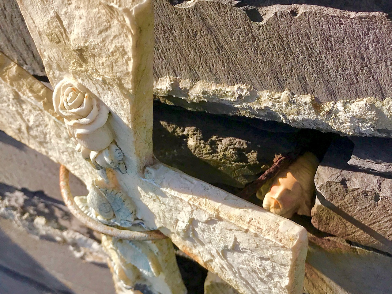
This is a cillin, down beside the river. There are lots of stories associated with it

Inish Beg abounds in both the wild and the tame. That’s not such an easy balance to maintain and it’s a real tribute to the team on the ground that manages and nurtures the estate. Mostly, of course, it’s down to the vision and hard work of Paul and Georgiana Keane who bought the place in 1997 when it was crumbling and neglected. The house, Georgie told us, was close to collapse and had to be completely re-done – new roof, plumbing, electrics and a complete re-furbishment. It’s hard to believe now, when you see the beautiful place it has become.

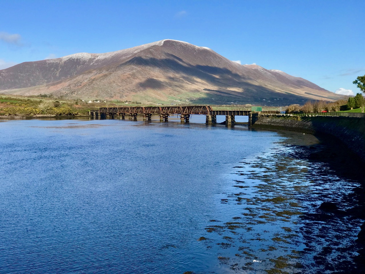
Paul and Georgie run it now as a hotel and wedding venue and it is totally set up for it. In fact it must be one of the most romantic venues in Ireland, ideally situated on an island on the Ilen River, accessible by an old stone bridge. It was originally O’Driscoll territory, but owned by the McCarthy family. When James Morrogh inherited it from a McCarthy relative in the 1830s he changed the family name to McCarthy Morragh – such stipulations were not unusual then.

In the 1890s the family built the grand house, and it is this house that is associated with its most famous inhabitant, Kay Summersby. A noted beauty, she was Eisenhower’s secretary in London during the war, and may (or may not) have had an affair with him.

She describes her early life at Inish Beg thus:

Our home, Inish Beg, was a somewhat run-down estate on a small but lovely emerald island in a river in County Cork. Our favourite pastime (I had a brother and three sisters) was to sail down that river four miles, to the Atlantic. There was a succession of governesses, hunts, spatting parents, riding in the fields and along the long avenue fringed with old trees . . . the usual pattern of life in that obsolete world.

The ‘usual pattern’ for some, perhaps – to me it sounds like a life of breathtaking privilege. However, like many such estates, it became difficult to sustain and by time the Keanes took it over it desperately needed their infusion of enthusiasm and capital. And what a magnificent job they have done with not only the house but the grounds as well.

There’s a walled garden (above) that’s full of organic goodies for the estate kitchens, and also features an indoor swimming pool! Tony O’Mahony, the head gardener, practises an organic philosophy and does not feel the need to eliminate wildness from the garden, which results in a delightful mix of plant life.

But we were here mainly for the woodland walks and we were certainly not disappointed. You could spend several hours wandering the trails here and right now the undergrowth is glorious. Bluebells were in abundance along with every wildflower that contributes to that colourful spring carpet that is so dear to our senses.

There are trails for the kids – pirates and a wildlife search are part of the system, as well as little fairy houses here and there.

There are lovely views (above) across the Ilen to the ruined church at Aughadown – burial place of the Tonsons that I wrote about in New Court Bridge – a Hidden Wonder. Surprisingly, beyond the church, you can see Mount Gabriel. I mention this because of its significance with our next find – a previously unrecorded cupmarked stone!

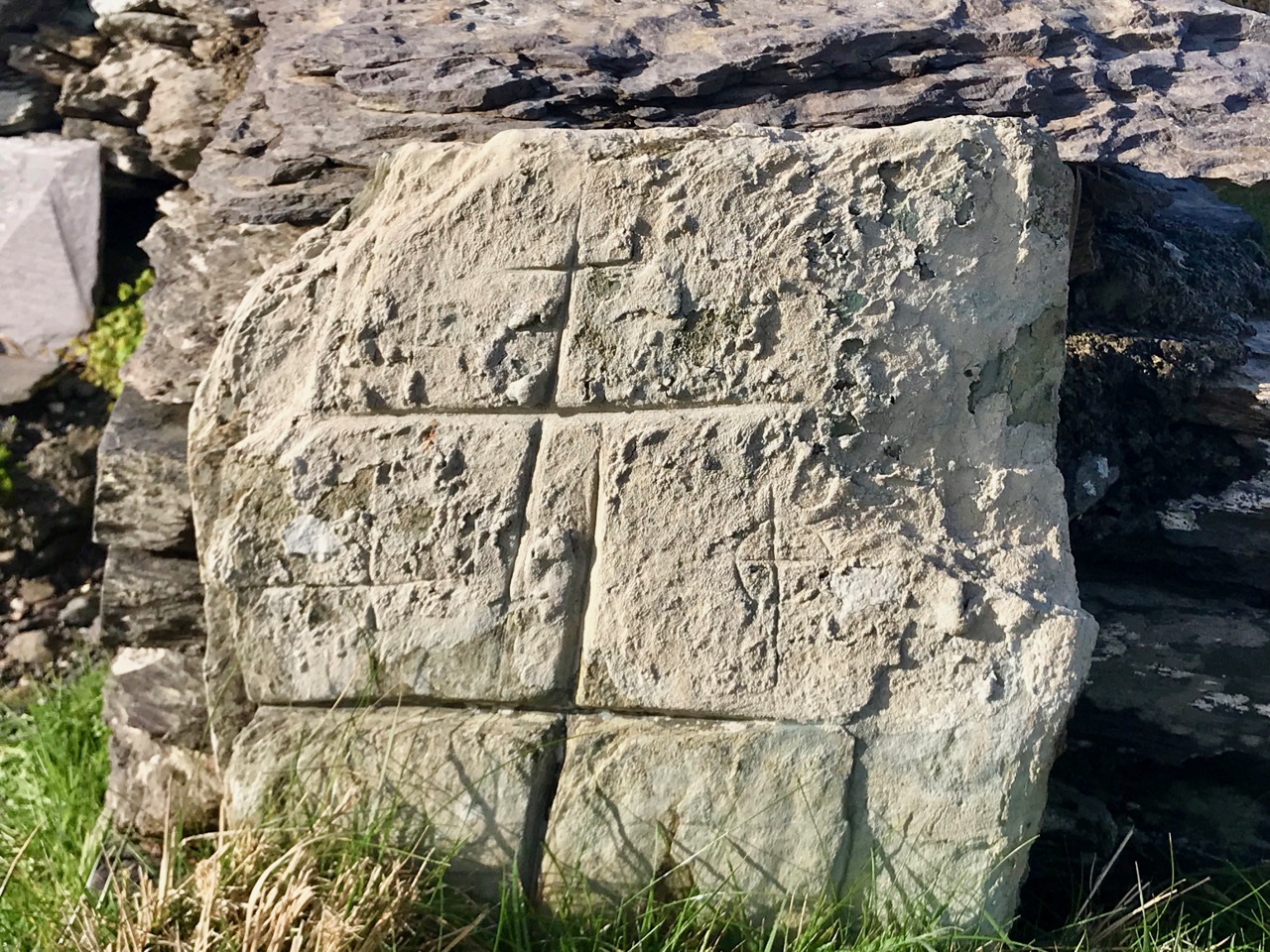
Regular readers know of our involvement with Prehistoric Rock Art – Neolithic or Bronze Age carvings on open air boulders and outcrops. The cupmark is the basic motif of all Irish Rock Art – a semi-spherical cup-shaped hollow (see more about Rock Art here and here and specifically about cupmarks here). Robert has an amazing eye for slight differences in rock surfaces and has developed a habit of examining every stone we come across for cupmarks. This time he struck gold! At least four cupmarks on the back of a stone along one of the trails.

We like to warn people that rock art can be a little underwhelming. I know these cupmarks don’t look like much, but they were probably carved several thousand years ago as part of a ritual we now know nothing about

The stone has been moved there from somewhere on the estate and the Keanes will try to track down where this was. It’s always important to see a rock like this in its context, of corse, but we are also curious to know if Mount Gabriel was visible from the location, as it is from so many of our West Cork Rock Art sites. We will be returning to do a proper record and see if we can add more information to the story before we send it in to be included in the National Monuments database.

There’s also a boulder burial on the estate, visible as you are leaving. It’s a pretty tumbledown affair, but still recognisable, and we found cupmarks on the capstone too. These may be already recorded, but we will let National Monuments know in case they aren’t.

Fabulous woodland walks, my fill of wildflowers, lovely vistas across the Ilen – and a new archaeological find. Too much excitement for one day!

Bluebell Time in West Cork

What is it about a bluebell wood that re-charges the batteries and lifts the heart? Perhaps it’s that amazing blue carpet that stops us in our tracks: it’s so unlike anything else in our natural world.

Or maybe it’s the fact that it lasts only a little while that makes it special. Like Easter eggs or Christmas carols, we would get tired of them if they were always with us – it’s their brief seasonality that makes us look forward to them (OK, maybe the Christmas carols don’t appeal to everyone in the same way).

Lower: Bluebells and Three-cornered Garlic

Even when it’s bluebell time, as it is right now, it’s not always easy to find a bluebell wood, because we don’t have expansive deciduous forest cover here in West Cork. I love the bluebells that line the boreens in places, growing up the hedgebanks, but it’s not quite the same thing as a woodland carpet.

Bluebells and Celandine growing on the bank on one of my favourite boreens

Let’s start with what a bluebell is – I’m talking here about our native bluebells (Bluebell/Hyacinthoides non-scripta. Or in Irish Coinnle corra, pronounced quinn-la curra). As you probably know, the imported Spanish Bluebell is everywhere now, and to add insult to injury has started to hybridise with our native Bluebell.

A garden near us has a lovely display of blue and pink Bluebells and Three-corned Garlic – unfortunately these are the non-native Spanish Bluebells, or possibly hybrids

Take a look at this excellent video from the Irish Wildlife Trust for a guide to how to distinguish between them.

Fortunately, we still have lots of native bluebells and I was lucky this week to get permission to stroll in my friend, Nick’s, little wood, and also to take a walk with Robert and Gill up the hill behind Long Strand. For more about what we were after, see Robert’s post on the cross today.

Upper: One of the little bridges over the stream. Lower: Bluebells and Irish Spurge

Nick’s little wood is down beside the sea on what was once an old homestead – you pick your way through a heritage orchard to get in there. It felt like an immense privilege to be the only ones there, to wander through the trees and over the tiny bridges.

Upper: one of the way to recognise a native Bluebell is to look at the anthers – they’re white or cream-coloured. Lower: a spontaneous white Bluebell in among the blue ones. It happens

Yesterday, because Robert wanted to see Lady Carbery’s Cross, we walked up Croachna Hill, behind Long Strand, near Rosscarbery. The strand was heaving with swimmers, surfers and loungers, the coffee truck and restaurant were packed and the guy who does the Wild Atlantic Seaweed Baths was out – it all looked so festive and summery.

Primroses and Bluebells

The walk up the hill was awash with wild flowers, besides the ones I’ve illustrated here we saw Common Dog-violet, my first Ragged-Robin of the season, Yellow Pimpernel, Ribwort Plantain, Navelwort, Ground-ivy and Herb-Robert.

I’d never seen that combination of Bluebell and Red-campion before (above). It’s pretty spectacular, and a reminder that colours in nature always harmonise. Together with the yellow of Celandine and Buttercup, and the lovely woodsy smells, it was a sensuous experience.

Upper: Looking back to Long Strand from Croachna Hill. Lower:  Bluebells, Celandine, Buttercup, and a lone Red Campion

Where are your favourite bluebell haunts, dear readers?


Mizen Magic 14: Lissagriffin

Lissagriffin (the fort of Griffin) lies on the south-facing slope on the northern side of the salt marshes behind Barley Cove. It is a sunny spot with panoramic views back to the hills beyond Goleen and across the salt marshes below to the dunes of Barley Cove and the sea beyond.

The Barley Cove salt marshes – sit on the wall and just listen to the breeze in the reeds

Nowadays, it’s a peaceful place of farms and pasture land, but there are clues in the landscape and the old maps and records that there was much more going on here in times past.

The most visible reminder is the ruined church, surrounded by a graveyard. Once, these lands were in the possession of the Rev Fisher  – remember him from my Saints and Soupers saga? They were associated with the Glebe Lands accruing to the Church of Ireland, which means that the rector was also the administrator of the graveyard, to whom you had to apply for permission for burial. The church and graveyard is known as Kilmoe (pronounced kill moo, meaning the the church of Muadh, although I haven’t been able to identify this saint), like the parish of the same name which occupies most of the Mizen west of Schull.

The graveyard has headstones going back to the 1700s, although I couldn’t find any from that era on my searches. All the local names are represented here, including the Burchills and the Wilkinsons of my Cousins Find Each Other post. It was in use as a burial plot during the Famine – a memorial plaque on the wall attests to this.

A feature of graveyards from this time was a watch-house, a reminder that bodysnatching was a lucrative trade. During the famine watch-houses also enabled people to be on the look out for dogs – there are accounts of dogs attempting to get at bodies barely covered by soil during this terrible time. There’s a ruined structure just inside the gate at Kilmoe (below), probably a watch-house from this time.

Like all historic graveyards around here there are many plots marked by simple stones, headstones and foot-stones, where people could not afford the services of an engraver. Remarkably, the knowledge of who is buried in some of those unmarked graves still resides somewhere, whether in church records or in the folk memory of local people. You can browse the listings of the graves here.

At the centre of the graveyard is a ruined church. It’s a very interesting structure to me, because I believe it is actually older than its normally-ascribed date. It was occupied, according to Brady’s Clerical and Parochial Records in 1581, when Dermot McCormack McCarthy was the rector and the church belonged to the College at Youghal and was dedicated to St Brendan. The Down Survey described it thus in 1700: Kilmoe : the church is ruinous, the walls that are standing are bad, built with stone and clay. The church stands about a mile from Crookhaven, to the westward near the head of Barlycove bay. 8A. of glebe on the north of the church; good land, set for £20 per an. There are the ruins of a vicaridge house joining to ye church-yard.

There are hints in the structure of the Romanesque style, which would place it in the 12th century. The east window is clearly Romanesque in construction, while the door, with its plain lintel and ‘relieving arch’ also appears so.

I am seeking some confirmation of this and will update this post if or when I get a response. The west end appears to have been two storey – the joist supports are still projecting from the wall, which means that the old ground level was lower than it is today and that the window was in the second storey. That window (below) is ogee-headed – a clearly gothic element, which means (if I am right about the west end) that it was inserted later. The whole church may have been modified many times over the years it was in use.

There is a record of a cross-inscribed stone inside the church – we have looked for this but cannot find it. It may be gone, or it may be partially buried in the long grass. There’s no sign of the vicaridge house joining to ye church-yard.

The unusual ‘buttress’ feature on the north wall

But the landscape around has other elements too – or rather had other elements. There used to be an O’Mahony Castle just to the east of the church, of which no trace remains today. We know of it from Griffiths map of the 1840’s, (below: apologies for the blurriness, it seems to be the best resolution one can get) where it is clearly marked as a ruin. While many of the O’Mahony castles were closer to the shore, this one would have benefited from all-encompassing views of both land and sea, and from proximity to the church, for worship. According to James Healy’s The Castles of County Cork, it was probably tenanted by the O’Meighans, a bardic family associated with the O’Mahony clan. Although there is nothing left, local people told Healy in the 1980s that the site was cursed and that bad luck attached to it.

The view out to sea from the church

Even older still are the numerous standing stones that dot the hillside to the east and north. The photograph below shows one – a rather stumpy example. And probably even older than those are the cupmarks reported on the rock face just to the east of the graveyard. We have searched for these too, but were defeated by the gorse and brambles.

Of unknown vintage is the bullaun across from the graveyard gate. Although bullauns are often carved in free-standing boulders, this one was scooped out of the bedrock: it is known locally as a wart well. Dip your finger in, say the requisite prayers, and your wart will disappear. We even found a small bottle for Lourdes holy water left by it on one of our visits, showing that it is believed to still possess curative powers. Robert agrees! Amanda has included it in her Holy Wells blog.

Next time you’re headed out to Barley Cove on a fine day, take a little detour up to Lissagriffin church. The views alone are worth it, although a little wander around the graveyard will do a lot to soothe your soul. 


Introducing the Holy Wells – of Kerry!

Remember the New Year Resolution – spend more time in Kerry? We lost no time in implementing it, and spent three days there this week. Our main purpose was to accompany Amanda and Peter as they started Amanda’s new project – to extend her Holy Wells of Cork recordings into Kerry as well. Of course, Robert and I had a small list of must-see items as well, which will likely appear in future blogs.

Above: Ballinskelligs Bay. Top photo: the mystical Skelligs. The larger one is Sceilg Mhichil (Skellig Michael) and the smaller is Sceilg Beag (Little Skellig). The Skelligs have featured in the Star Wars franchise, but are better known to us here as the home of hermit monks in the Early Christian Period

It’s always great fun to be out and about with Amanda and Peter. We had a few misgivings about the weather forecast, and indeed we had everything thrown at us – snow, hail, sleet, rain, gales – and brilliant sunshine! The sunshine persisted for our main day, to our delight, but the weather gods made up for it that night with a howling gale that knocked out the power to our hotel, the Royal Valentia. Undaunted, they served us up a great breakfast, and figured out how, with no electricity or internet, to charge our credit cards.

Robert’s post is mainly about Valentia Island, so I am concentrating on the holy wells. All of them will be written up in Amanda’s customary detailed style on her blog, so this is just a flavour of what we saw. By the way, if you are new to holy wells, check out her series of “On Wells” posts now. It will get you up and running.

St Crohane’s Holy Well site, with the well in the background, a Marian grove in the centre, and a mass rock in the foreground

Our first well was one that Robert and I had tried to find and failed on a previous trip to Kerry. This time we were with the expert and there it was – St Crohane’s well, behind an old graveyard with not one but two ruined churches and spectacular views across to the Beara. The well was once the centre of a mighty three-day pilgrimage and although that no longer happens, the well is cared for and visited.

The view from St Crohane’s, across to the Beara

I was thrilled to find a Richard King stained glass window in Ballinskelligs (future post) in a church dedicated to St Michael, patron saint of the Skelligs. Below the church is the holy well also dedicated to Michael. This is a curious site (below), almost certainly built on a fulacht fia, like the Trinity Well in Duhallow. This also was the centre of a huge pattern in its day.

We visited two wells dedicated to St Finnan (or Finan or Finian), a monk who is also associated with Lindisfarne and Iona. The first of these was a neglected little well on St Finian’s Bay – the pounding surf was a bit of a distraction (see below and final picture).

The neat little well house is the beehive-shaped structure to Robert’s left

The second was on Valentia Island and took a bit of finding until we stumbled upon the magic path through the woods. A classic well, with everything you needed to have a drink, and surrounded by slabs of slate. Robert had a sip – brave man, and now apparently safe from rheumatism.

Amanda always comes prepared with detailed research and notes, but wells can still be difficult to find

Our other Valentia well was dedicated to St Brendan (in one account, St Finnan was one of his acolytes) and was located at an amazing, windswept site, with crude cross slabs and a possible turas (pilgrim route) through the bog. Robert has more images of this haunting place.

Amanda gazes out across the bog, trying to make out the traces of a pilgrims’ path and possible stations

Two little wayside wells were encountered along the way, one along the road and one in the middle of Caherciveen – this last one, Well of the Holy Cross, a little sad and neglected, as urban wells tend often to be.

Although this was a holy well, dedicated to St John, it appears to have been repurposed as a Marian grotto, with St Bernadette in a small shelter of her own

Our final well was also the most spectacular – St Fursey’s well, located on the slopes of Knocknadobar (cnoc na dtobar – mountain of the well). Once, people climbed to the top of the mountain at Lúnasa for a three day festival. Although the festival is no more, in the 1880s local people erected stations of the cross, 14 of them, going all the way up the mountain to the top. Some of us managed to get to the second station, but saw a hardy soul way above us, well on his way.

Station 2 on the pilgrim trail from St Fursey’s Well to the top of Knockandobar

As ever, organising a trip around holy wells provided us with three days of adventures and experiences in jaw-dropping scenery and the opportunities to do lots of side-trips. The light in January is clear and sparkling and the roads are quiet, unlike at the height of tourist season.

The white dots going up the hill are the Stations

Although many restaurants, hotels and b and b’s close for the winter, enough remain open so that a hearty bowl of soup and a good coffee is never too far away. And three cheers for The Royal Valentia – open all year, great food, friendly staff and good in a crisis!


Valentia Adventure

At the very end of January – when we should have been in the dark depths of winter – we headed off to Valentia Island in County Kerry, and enjoyed sublime golden sun. This time of the year often gives us the best light: we experienced this on our expedition through the Yellow Gap in West Cork a fortnight ago, and again during these three days in our neighbouring county last week. It’s to do with the low sun: somehow it enriches the amber hues of the landscapes, which are themselves enhanced by backdrops such as the one above. An ancient stone is set against a distant turquoise ocean and dark, snow-capped mountain peaks.

Holy wells were on the agenda (see Finola’s post here), as we were joining our friends Amanda and Peter Clarke from the Sheep’s Head. Amanda has nearly come to the end of her chronicle which records all the Holy Wells in County Cork, and she is now starting to explore those in County Kerry. I’m not going to say too much about the wells we saw, as Amanda will cover them in great detail, but the expedition certainly provided great opportunities for observation and photography, and caused us to wonder – again – at this unique aspect of Ireland’s history and traditions.

All the photographs above are from a remote and atmospheric site on the north west side of Valentia Island: St Brendan’s Holy Well. It’s a long way off the beaten track: desolate, bleak and boggy – but justifies making the effort. There are ancient stone crosses, carved slabs, cures to be had, and history. St Brendan himself journeyed there from Tralee in the fifth century, climbed the cliffs at Culoo, and found two dying pagans at the site: he anointed them and they became Valentia’s first Christian converts.

Above – the way to St Brendan’s Well, Valentia Island, passes by O’Shea’s Pub . . . one of the furthest flung bars in the world, that you can’t—and could never—buy a proper pint at . . . The story is here.

I certainly endorse that sign in the centre, seen on Valentia Island. Hare trapping in South Kerry is illegal – and so it should be! But – how could we not follow a sign that says: Slate Quarry – Grotto?

The Grotto – in this case a statue of the BVM together with Saint Marie-Bernadette Soubirous, the girl who witnessed Mary’s apparition in Lourdes – was installed in the Marian Year of 1954 in a cave high above the entrance to the Valentia Slate Quarry on Geokaun Mountain, at the north end of the Island. The Quarry had been opened in 1816 and supplied slate to the Palace of Westminster, Westminster Abbey, St Paul’s Cathedral, London railway stations and many another building project. The quarry excavated a huge cave into the mountainside, and closed after a major rockfall in 1910.

Fr James Enright, who was the PP of Valentia in the Marian Year, saw a golden opportunity in such a setting for a commemorative grotto. Fr Enright decided exactly where the statues were to be positioned, but the burning issue was how were these heavy items going to be put in place and worked upon at over 90 feet from ground level? The answer came in the building of a deal timber ladder.


Jackie Clifford , who was a blacksmith based in Gortgower, made the iron to bind and reinforce the ladder and was helped in his forge by Denny Lyne and subsequently aided by other islanders. Having been transported to the quarry in sections, it was assembled there and put in place by the volunteering islanders. The ladder was over 100 feet long, being four feet wide at the bottom narrowing to a foot. and a half on top. The sections of ladder were joined at the various points with a four foot lap. Many island volunteers were enlisted with each townland taking their turns to work. The initial work involved levelling a massive mound in order to form a proper base. This was quite labour intensive, being done with pick and shovel. The ladder was hauled into place by means of a block and tackle pulley system with people at the ends of ropes from above and to the sides in order to control it and put it in place. As one islander succinctly put it “The greatest miracle to happen there was the erection of the ladder”.


Subsequent to the ladder being put in place, a number of daring and intrepid islanders had to climb it for the purpose of erecting the statues. The statues were hoisted up by rope with other tools and building materials. The concrete for the base was mixed by shovel above.

(Quote from The Kerryman, January 2015)

The Quarry has recently reopened, and it’s quite surreal to stand in front of the grotto with the sound of heavy machinery reverberating at the huge cave mouth from deep within the mountain.

Have a look again at the signs above: one points to ‘Tetrapod Trackway’. This is surely a must-see for any visitor to Valentia Island as the fossilised Tetropod footprints here, representing the point at which life left the Devonian Seas 370 million years ago to begin to evolve on dry land, are the best examples of only four sites found to date in the world! We hurried to have a look – but the site was closed for repairs. You can see a picture of the tracks here.

In the winter sunlight, the little village of Portmagee which stands at the threshold of Valentia Island and connects to it by a bridge opened in 1971, looks like a picture postcard. In fact, the bridge was opened twice – once on New Year’s Day, when it was blessed by the Bishop of Kerry – and again at Easter, because there was some debate about whether the first opening had been ‘official’ or not!

Here’s a railway map and photo dating from around 1901 showing ‘Valentia Harbour Station’. In fact, it’s not on the island at all, although Knightstown – the ‘planned village’ designed by Alexander Nimmo for the Knight of Kerry in the 1830s can be seen across the water. The station – the terminus of the most westerly railway in Europe – is on the mainland, to the east of  Valentia Island, which could be reached by a ferry. The Farranfore to Valentia Harbour Railway was 39½ miles long and operated from 1892 to 1960. The photo below shows the Valentia River Viaduct just outside Cahersiveen, now derelict but hopefully to have a new lease of life when a planned cycling greenway is developed along the old railway track.

Valentia Island has a great deal more to offer than I can show in a brief post. It’s well worth making the journey and staying for a little while: there is such varied landscape to be experienced – a microcosm of the West of Ireland, in fact – and much history if you want to delve under the surface.

The tailpiece shows a view from Knightstown looking across to Valentia Harbour on the mainland and the site of the former railway terminus:

West Cork Obscura – Finola’s Picks

The popular Atlas Obscura defines itself as the definitive guide to off-the-beaten-track and little known wondrous places. So we’ve captured that idea and, as our Christmas present to our readers, bring you our own carefully-curated, slightly eccentric, Roaringwater Journal Guide to West Cork’s Hidden Wonders. Robert’s selection is here. No well-know tourist spots for these posts! No car parks and visitor centres! You may need wellies for some, a good map for others, and, although all are accessible, some may require permission.Each place I recommend will link to a blog post with more information. As an example, Sailor’s Hill, just outside Schull (above) is an easy walk and look what you get at the top! 

This is the view from Brow Head, looking back towards Crookhaven, and Mount Gabriel in the distance. Brow Head is much less visited than Mizen Head, but just as spectacular

I’m going to start with some archaeology and a couple of spectacular sites. The first is the Kealkill Stone Circle – but this isn’t just a stone circle, it’s a complex of monuments that includes a five-stone circle, a radial cairn (very rare in this part of the world) and two enormous standing stones. The views are immense in every direction, and the site is easy to find.

We all know about Drombeg – and we love it when the sun goes down at the midwinter solstice, and even when it doesn’t. But fewer people know about another stone circle, equally spectacular, with a spring equinox orientation. It’s called Bohonagh and it’s quite a complex. First of all, there’s a boulder burial, with quartz support stones and cupmarks on the boulder. Then there’s a cupmarked stone, partly hidden in the brambles between the boulder burial and the stone circle. Finally, there’s the circle itself, almost complete, with views in all directions.

Equinox sunset at Bohonagh

We were lucky to have a session there one equinox, and another one with Ken Williams of Shadows and Stone. For access, park just off the main road, across from the salmon coloured house 4.5km east of Rosscarbery and walk up the farm road to the barns and from there to the top of the hill. This is a working farm – please close all gates and be respectful of animals!

Maughnasilly Stone Row broods on the hilltop

A stone row to round out the archaeology sites – this one is at Maughnasilly and I chose it because it’s been excavated, so there’s an informative sign, access is easy and it’s a beautiful, atmospheric site, overlooking a small lake. The row has been calculated to have both lunar and solar alignments.

And from the ground…

A couple of churches now, beginning with the Church of Ireland Church of the Ascension in Timoleague. This is one of those places that is dripping with unexpected stories. As soon as you go through the door your jaw will drop – the whole church, floor to ceiling, is covered in mosaic, partly paid for by an Indian Maharajah. Read the story here and here – and look carefully at the stained glass windows, some of them are among the oldest stained glass we have in Ireland. The key used to be at the grocery store on the main street, but I’m not sure where it is now, so you may have to ask around. Let us know if you find out.

The interior of the church, and one of the beautiful Clayton and Bell windows

You may wonder at my next choice – it’s not everyone’s cup of tea – but the modernist church in Drimoleague is the work of Frank Murphy, the architect hailed as Cork’s ‘Unsung Hero of Modernism’.

I love the spare minimalist space, very rare in West Cork, but it’s the stained glass windows that drew my attention. It’s not that they are particularly beautiful or skilfully done: they’re by the Harry Clarke Studios long after Harry himself had died. It’s that they fascinate me as a social document – they are, in fact, a prescription for how to live your life as an Irish Catholic in the 1950s. As such, they will resonate with anyone of my vintage. Research by the brilliant young scholar, Richard Butler, has revealed that the design was practically dictated by Archbishop Lucey, still a name to invoke an image of the all-powerful churchman of the 20th century.

And a final church, but this one strictly for the windows. (No – not St Barrahanes in Castletownsend for the Harry Clarkes – everyone knows about them already, and this is a selection of lesser-known wonders.) Do NOT go through Eyeries, on the Beara Peninsula, without stepping into the little church of St Kentigern. Here is where we were first introduced to the work of the stained glass artist, George Walsh.

The Annunciation and Nativity window

When Robert wrote his original post, we couldn’t find out much information on George Walsh, but now he has become a friend and I have written about his work for the next issue of the Irish Arts Review (due out in March, 2019) and spent many happy hours photographing his windows and his artwork around Ireland. It’s bold, graphic, modern and incredibly colourful, and the windows in Eyeries, along with the religious themes, tell the story of Ireland and the Beara through time.

Some places to visit now for a good walk or a swim. First, one of my favourite walks is to hike up to Brow Head, at the end of the Mizen Peninsula (you can drive up too, but pray you don’t meet a tractor coming down) and then walk out to the end of the Head (see the second photo on the post for the view from the top of the road). Stop first to explore the ruins of the old Marconi Station – there’s also a Napoleonic-era  signal station and a WW2 Lookout Post. Then wander through the heather and the low-growing gorse until you get to the part where the sea is crashing below, with vertiginous drops off either side. I will leave it to you how far you go from there!

Brow Head showing the signal station and Marconi station silhouetted against the evening sky

Although Barley Cove is well known, Mizen locals love Ballyrisode Beach for a swim or a lounge in the sun. White sand, sheltered bays, and water warmed by running over the shallow bay. The final little beach holds a secret – a Bronze Age Fulacht Fia or Water-Boiling Site, that Robert and I recorded for National Monuments this summer. It was an exciting find, hiding in plain sight. The beach has an association with pirates too!

Ballyrisode Beach – yes, the water really is this colour. The three sided rectangular stone thing is the fulacht fia

The final choice for a walk is Queen Maev’s tomb, a short hike up from Vaughan’s Pass car park, up behind Bantry. For this photograph I am indebted to Peter Clarke, of the wonderful Hikelines blog. He and Amanda (with whom we have explored SO many holy wells)  were our companions that day. When you reach the top there is a small wedge-tomb, but this is one place where the journey is the real story, with the Mizen, the Sheep’s Head and the Beara all spread out before you.

Photograph © Peter Clarke

I leave you with a detail from the George Walsh windows in Eyeries, together with the poem the scene is based on, Pangur Bán, written in the 9th century by an Irish  monk labouring away in a scriptorium in Europe. Here is the poem read, at a memorial service for Seamus Heaney, first in the original Old Irish and then in Heaney’s translation.

Merry Christmas from us! If you live here, get out and about this year to some of our picks, and if you don’t, come see us soon!