Scratched Stone – Scratched Heads

stone scratches

Aultagh Ogham Stone

One thing always leads to another – that’s something you can be sure of when we are on our archaeological adventures. A case in point was a recent expedition to have a look at Ballynacarriga Castle (not far from Dunmanway, County Cork: 16th century – notable for having a Sheela-na-gig carving built high up into the outer masonry wall, and some unusual carved inscriptions on the internal stonework).

Ballynacarriga Castle (left) with its Sheela-na-gig (right)

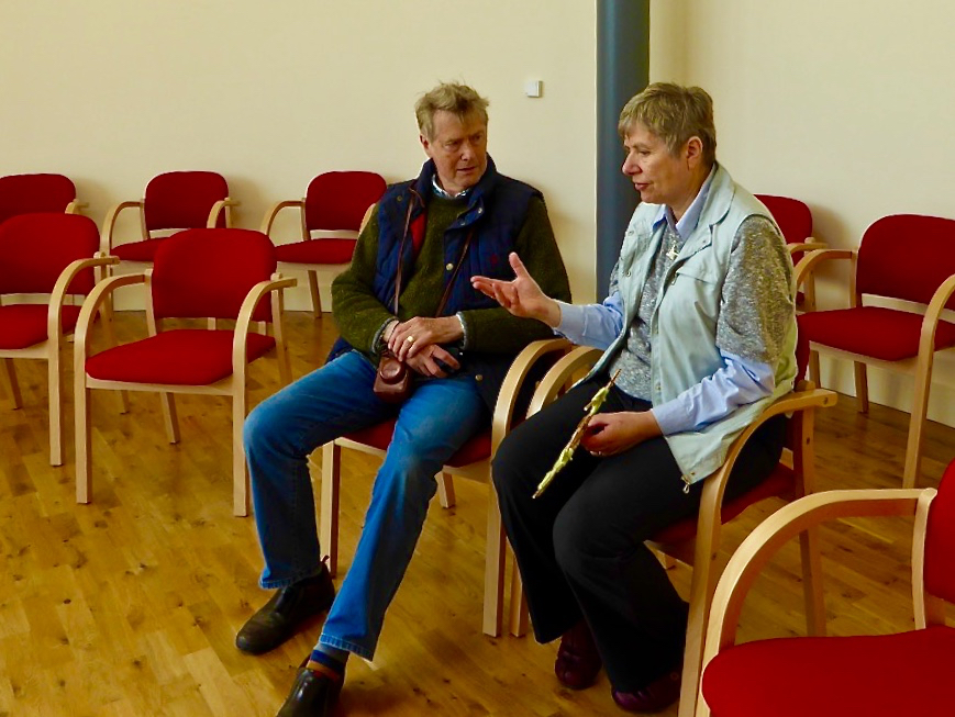
Perhaps these various stone scribings turned our minds to the subject of Rock Art (easily done). Our excellent guide on that morning, Margaret Murphy of the Skibbereen Heritage Centre, offered to show us an Ogham stone not too far away, in the townland of Aultagh. How could we refuse?

finding the stone

Assistance required in finding the stone!

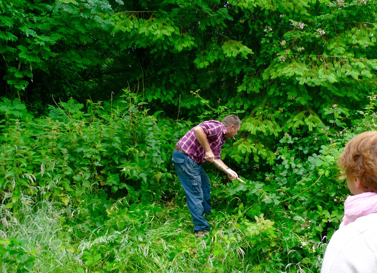
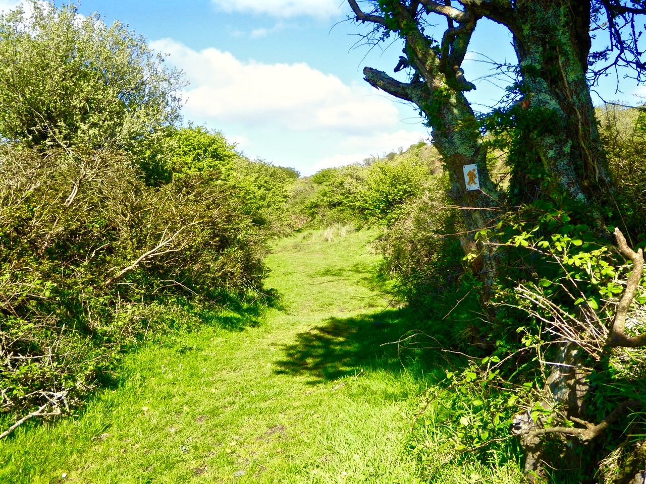
Our goal was beside an ancient track in Aultagh Wood (Coil an Ailtaigh), approached from a private driveway. Margaret knew the owner who readily gave us permission to have a look. In fact, he provided sterling service after we had searched in vain for the elusive rock – opportunely arriving with a pole to clear the thick undergrowth, and soon revealing this modest boulder to our eager gaze.
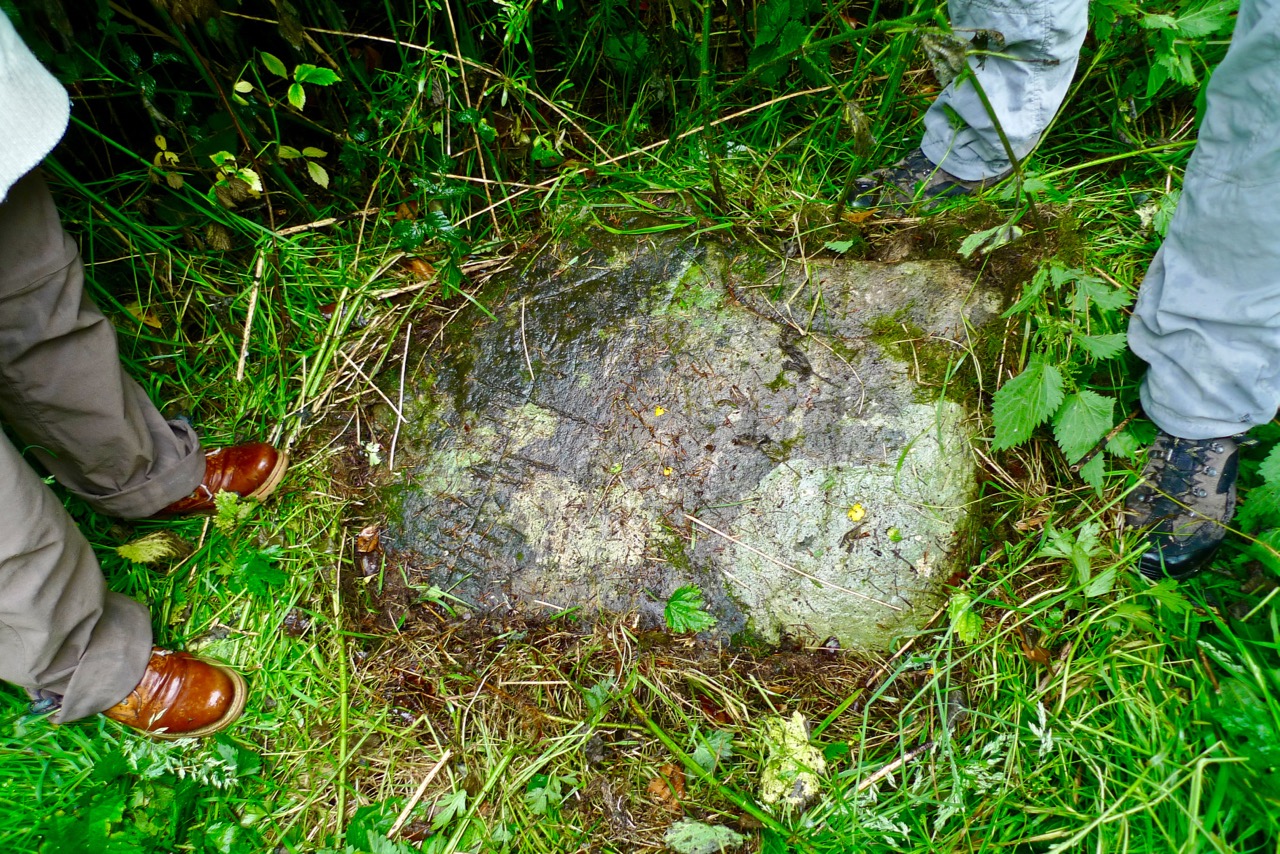
stone discovered

Stone uncovered…

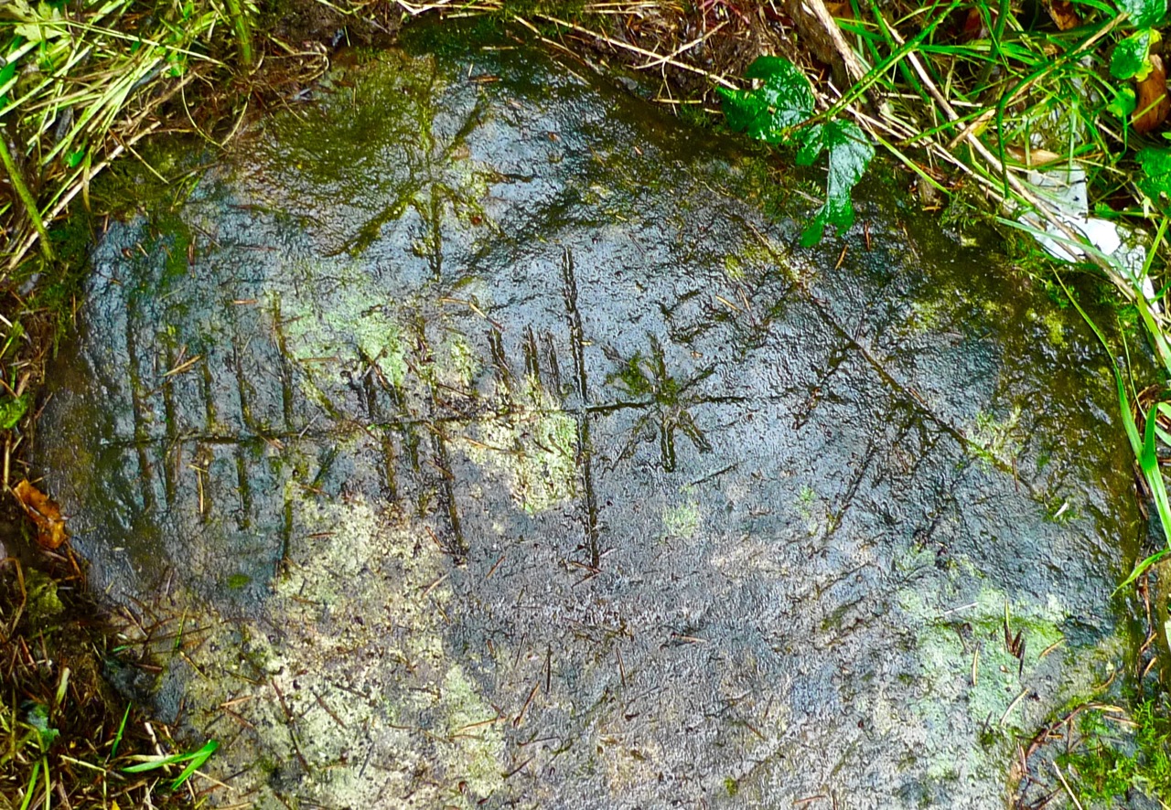
The stone lies close to a drainage ditch and has possibly arrived there from another location at some time in its history. In one area the surface of the rock has been damaged, affecting part of the scribings: it may be that it was once standing – now it is prone with carved marks clearly visible on the upper surface.

stone in context

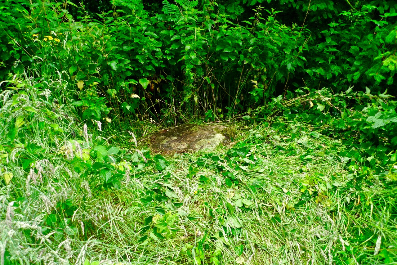
The Aultagh Ogham Stone in context

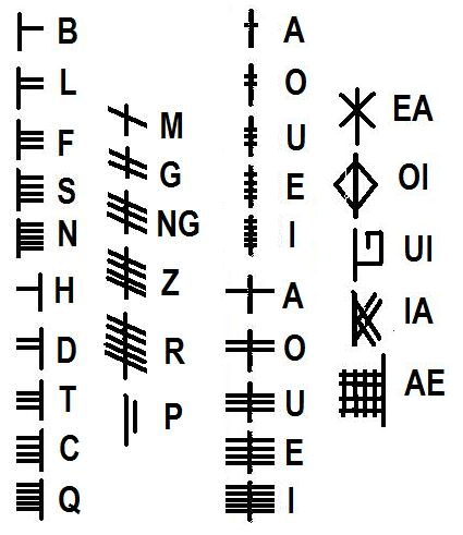
The last time I wrote a post about ogham (here it is) I gave a very general overview of the subject. Ogham stones are concisely described by the Irish National Monuments Service as:

…upright monoliths or recumbent slabs, onto which ogham script has been incised. Ogham script consists of groups of 1-5 parallel lines and notches cut along the side or across the edge of a stone to represent the sounds of the Irish language. It is usually read up the left angle. The inscription gives a person’s name (usually male) and immediate antecedent/s or tribal ancestor. The stones may have functioned as memorials, grave markers or territorial markers and date from the late 4th to the early 8th century AD.
Fine examples of ogham stones in Ireland

Here’s the entry in the National Monuments Service records for our Aultagh stone:

Description: On a W-facing slope, in Aultagh Wood. Fallen stone (L 1.1m; 0.7m x 0.3m) with inscription on flat face. According to Macalister (1945, 75) ‘fashioned by an illiterate artificer, copying by rote from a wooden model cut for his guidance’ and reading UBEDABO ALTASI.

MacalisterThat’s quite a bald statement from Robert Alexander Stewart Macalister who was Professor of Celtic archaeology at University College Dublin from 1909 to 1943, during which time he compiled and edited the catalogue of all known ogham inscriptions from Britain and Ireland. Macalister’s theories on ogham are generally out of favour today (some commentators have claimed that his interpretations are gibberish) but he seems to accept the Aultagh stone as being within the early medieval ogham tradition. Yet it seems to me very different from many of the other stones we have seen: it is very sharply incised, obviously with a fine-tipped metal tool, whereas a majority of the traditional or ‘classic’ ogham stones are larger and more robustly carved.

Possible ogham stone at Maulinward, West Cork (left) and others from the Stone Corridor at UCC

When you begin to delve into modern literature on ogham you realise how very many varieties of examples there are, and also how many differing interpretations there are of how to ‘read’ the script. This was monumental writing, labour intensive and time consuming to undertake. For this reason it is generally supposed that ogham was ostensibly reserved for marking important graves or places, and that the inscriptions are all names.

Aultagh Inscribed completeAultagh Ogham Stone – ‘classic’, ‘scholastic’ – or ‘fake’?

There are suggestions that ogham inscriptions for more general – and less monumental – usage were once carved on wood, and might have been language primers for the bardic poets. Later inscriptions are sometimes termed ‘scholastic ogham’ deriving from the fact that the inscriptions are believed to have been inspired by manuscript sources, instead of being continuations of the original ‘monument’ tradition. Hallmarks of scholastic ogham are the median line and scribings being on the flat face of a stone (as at Aultagh) rather than on the edge. Ogham was occasionally used for notes in manuscripts down to the 16th century, and the burgeoning interest in all things antiquarian from the 18th century onwards led to  a popular ogham revival. A typical example, from the graveyard in Ahenny, Co Tipperary, has an English inscription dated 1802 and this in ogham: FA AN LIG SO NA LU ATA MARI NI DHIMUSA O MBALLI NA GCRANIBH, interpreted as ‘Under this stone lies Mary Dempsy from Ballycranna’. Macalister takes the view that this inscription, and others like it, were written “with much more zeal than discretion”, while some scholars have suggested that this more modern usage of the scribing should be termed ‘fake ogham’.

Aultagh Incised Stone

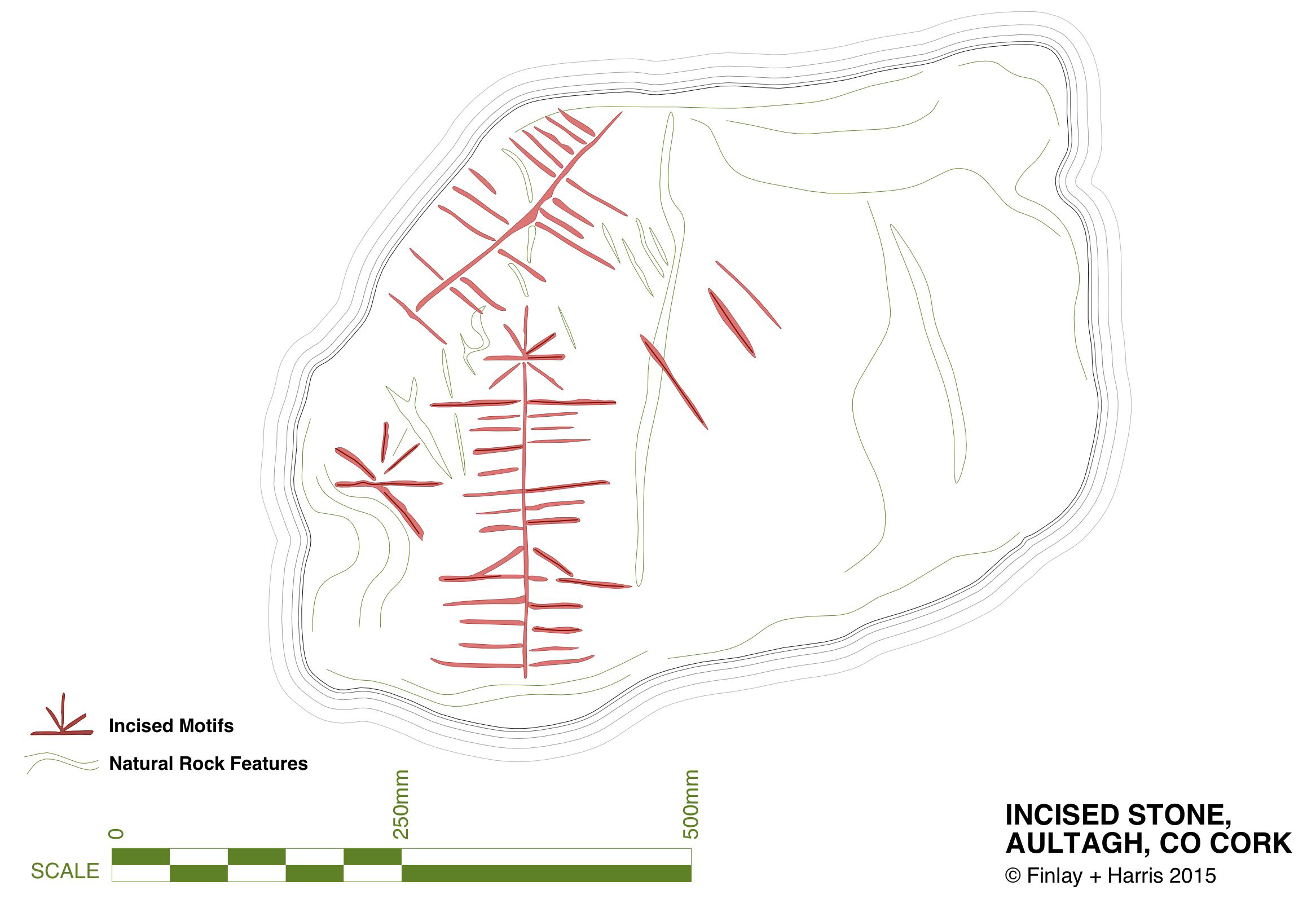
My own drawing of the Aultagh inscribed stone – traced from detailed photographs

You may like to have a go at translating the inscription at Aultagh for yourself. Firstly you will need to select your decipherer: a quick internet search will show that there are many, and also a whole lot of inconsistencies. But perhaps this is all part of the head-scratching: and also part of the whole fascination of a historical subject where many of the elements can only be guessed at…

ogham-alphabet

A Tale of Four Churches

Kilcoe Medieval Church

Kilcoe Medieval Church

Kilcoe is a magical place. The story of its four churches leads us from the dawn of Christianity in Ireland through turbulent times and many centuries when religious differences and sectarian strife marked all aspects of life in Ireland.

The four churches: 1, Kilcoe Medieval Church  2, Mass Rock 3, Kilcoe 19th Century Church 4, Kilcoe Modern Church of the Most Holy Rosary

The four churches: 1, Kilcoe Medieval Church. 2, Mass Rock. 3, Kilcoe 19th Century Church. 4. Kilcoe Modern Church of the Most Holy Rosary

We love going down to the Medieval church at Kilcoe or wandering the boreens along the Roaringwater River. Those boreens are now part of the Fastnet Trail Network and last weekend, at the Launch, we were treated to a talk about the locality from Fr Patrick Hickey, Parish Priest of Timoleague and a noted scholar of West Cork History. This blog post was inspired by that talk – thank you, Fr Hickey!

Inside the church, showing the ogival windows, the altar, piscina or stoup, and a small recessed cupboard

Inside the church, showing the ogival windows, the altar, piscina or stoup, and a small recessed cupboard

Kilcoe gets its name from St Coch, a nun said to be a colleague of St Ciarán of Cape Clear, who preached Christianity in Ireland before St Patrick, in the 5th Century. It is possible she founded a church here, but what we do know is that one was built in Medieval times – a building that still exists although the ivy is doing its best to take it over.

It’s a beautiful and atmospheric place, on the water, overlooking Roaringwater Bay. Two castles are in view: Kilcoe and Rincolisky, a McCarthy and an O’Driscoll Castle respectively. Each has a fascinating history that deserves a post of its own sometime. Some special features remain in this ruined church – windows with carved ogees, a lovely arched doorway, a piscina (for washing vessels) or stoup (for washing hands), a recess for storing vessels and the remains of a possible altar.

We don’t know exactly when this church was built or by whom, but we do know it was in ruins by 1615. Perhaps it was destroyed by the same forces that laid siege to Kilcoe Castle after the Battle of Kinsale in 1601 – a period that marked the end of the Old Gaelic Order in West Cork.

The Medieval church, with Kilcoe Castle in the background.

The Church, with Kilcoe Castle in the background

The rise of the Protestant Ascendancy class in the aftermath of that fateful battle privileged the Church of Ireland (transplanted Anglicanism) over the Catholic faith and a series of new laws, gradually getting harsher, were designed to suppress ‘Romanism’. This culminated in the enactment, in 1695, of the infamous Penal Laws. While attendance at mass was initially tolerated, churches could only be built from wood and away from roads. Eventually, priests were expelled from Ireland and after that mass had to be held in secret, with priests moving from hiding place to hiding place. At Roaringwater Pier Fr Hickey talked of the typical cargo of the smuggling ships that plied their trade from there: each ship to arrive from France would be carrying tobacco, brandy – and a priest!

From this period we find the Mass Rocks scattered around rural Ireland, identified on the basis of local tradition. The one at Ardura Beg is just up from a tiny pier that would have offered possibility of a quick escape. Many stories have come down of lookouts warning of the approach of the ‘red coats’ and the miraculous ways in which priests would make their escape. (See here and here for examples.)

Sheona and Amanda examine the mass rock at Ardura Beg

Sheona and Amanda examine the mass rock at Ardura Beg

Places of worship must be located where they are accessible and the first two are close by the sea, which afforded the easiest travel routes in Ireland for most of its history. However, roads were constructed eventually and the next two churches were located along these new routes. The first one, we’ll call it the Old Church, was built along the new road that led from Skibbereen to the Beara Peninsula. After 1778 the anti-Catholic laws were gradually relaxed, although it was not until 1829 that full Catholic Emancipation was won by Daniel O’Connell. The Old Church was probably built around 1800 and was a simple ‘barn-style’ edifice which served an impoverished and famine-stricken populace for a hundred years.

Left, the Old Church near Roaringwater Pier. Right, an example of a simple ‘barn style’ church in West Cork

By the turn of the 20th Century it was deemed unfit for purpose. Nowadays it is a gentle green space, lovingly tended and in use as a grotto. Children were buried there – it was not a cillín, but a consecrated graveyard – and a memorial remembers them now.

Grotto and Chirdren Memorial. A place for contemplation

Grotto and Children’s Memorial. A place for contemplation

Catholic Emancipation ushered in a long period of church building by the newly-confident Catholic majority. The new road from Skibbereen to Ballydehob was constructed at the end of the 19th century and the New Church was built there in 1905, right beside the bridge over the Roaringwater River.

Kilcoe Church and Bridge

Bridge over Roaringwater River

The two styles of churches common at the time were Neo-Gothic, Influenced by continental cathedrals, and Hiberno-Romanesque which took its inspiration from the Early Medieval Romanesque style of Old Ireland and featured wonderful doorways and round towers. The Kilcoe New Church, the Church of the Most Holy Rosary, was built in the Neo-Gothic style, with a large rose window at the eastern end.

Kilcoe, Church of the Most Holy Rosary

Kilcoe, Church of the Most Holy Rosary

Originally the side-aisles did not have seats – poorer people could stand there for mass, while those who could afford a penny would occupy the pews. As the church fund grew, thought was put into ornamentation and stained glass was commissioned for several windows. The rose window was executed by the Harry Clarke Studios in 1943 and shows scenes from the life of Christ and of Mary.

The Rose Window, by the Harry Clarke Studio

The Rose Window, by the Harry Clarke Studio

The Altar and side windows were the work of Sarah Purser’s Tower of Glass. The choice of stained glass – from Dublin-based Celtic Revival artists rather than the English or Continental firms that supplied most church glass at the time –  was a choice that demonstrates the nationalistic feelings that were rife in West Cork at the time.

Irish History is written large on her landscape. In this one small area – these sites are within a couple of kilometres of each other – we see encapsulated sixteen hundred years of history, starting with St Coch and ending with the latest incarnation of a church at Kilcoe. Their beauty and their peaceful settings have been hard won. They should serve to remind us that peace and tolerance must always be cherished and safeguarded.

Rincolisky Castle from Kilcoe Medieval Church

Rincolisky Castle from Kilcoe Medieval Church

Closer Encounters – Fastnet Trails

The view from Cappaghglass, on the Rossbrin Walk

The view from Ballycummisk, on the Rossbrin Walk

Today (Sunday 28 June) a newly established system of walking trails was formally launched – by longstanding local TD (now retired) Jim O’Keefe – at Aughadown: we were part of the crowd

The Unveiling – from top left: mover and shaker Eugene McSweeney with Jim O’Keefe; Jim and the Fastnet Walk Trails Group Committee cutting the ribbon; on the inaugural walk – Fr Patrick Hickey giving us the low-down on smuggling at Roaringwater Pier; the wonderful Kilcoe National School Band
At Kilcoe Trailhead - the walks unveiled!

At Kilcoe Trailhead – the walks unveiled!

Rediscovering what we’ve only recently discovered… is that the best way of describing our experiences exploring the just launched Fastnet Trails? We have been traversing and driving around the boreens – local lanes and byways – that permeate this beautiful stretch of coastline and country on our own peninsula (Ballydehob is colloquially termed ‘the Gateway to the Mizen’) for the full two years that we have lived permanently here at Nead an Iolair. We have taken in the vistas – from the windows of our car – and appreciated the profuse combinations of sky, sea and mountain as we passed on our way; now, we are seeing everything anew, and in closer focus, because we have started to walk the trails.

Cornflowers

Old Copper Mine at Ballycummisk (Rossbrin Walk)

Old Copper Mine at Ballycummisk (Rossbrin Walk)

Towards Mount Gabriel - Butter Road Walk

Towards Mount Gabriel – Butter Road Walk

It may seem strange that many of these walks are along roads but don’t let that put you off! Remember that here in rural Ireland the old lanes were made to serve farmsteads and are little used today by anything more than very local traffic. I did the hike home from Ballydehob this morning (after my usual excellent coffee break in Budds) on the long route, passing by Ard Glas (Ballydehob Rossbrin Walk): I pootled along for well over an hour and didn’t see a single vehicle in the whole of that time! In fact, a passing car (or bicycle or tractor) is an event: invariably it involves a pause in walking while the time of day is passed in leisurely conversation during which acquaintances are made and news is passed on…

Have you time for a chat?

Have you time for a chat?

P1050062

lisheenacrehig map

Before the official opening Finola and I undertook one of the walks (Lissheenacrehig Walk, starting at Kilcoe Trail Head): we deliberately chose the one that seemed perhaps the least interesting as it heads north inland and doesn’t pass directly by Roaringwater Bay. I’m not sure what we expected – after all, we had travelled all the little roads on this route by car previously – we are great explorers! In fact, our eyes were opened and we were surprised to be presented with wide views focussing on Mounts Gabriel, Kidd, Corrin and all the rugged uplands in between, and to be given the huge bonus of time to stop and scour inviting rock surfaces for new examples of Rock Art (we didn’t find any). But also it was the closer encounters which we really valued: a wealth (if that really is the right word?) of ruined sheds and cottages; wells, walls and wild flowers; an old burial ground with its memories of lives lived; the tumbling waters and green rocks of the Roaringwater River just before it empties itself into the Bay; archaeology (viewed from a distance on this occasion – the standing stones and ring forts are on private land and – as always – permission should be sought from the owners prior to visiting: that, of course, creating further opportunities for chat and dawdling).

View to Mount Kidd, Rossbrin Walk

View to Mount Kidd, Rossbrin Walk

Butter Road Walk

Butter Road Walk

The signage on these walks is clear but discrete – you’d have to try very hard to lose your way. Very occasionally there are information boards: these have been well thought out and attractively drafted. At the end of our sample walk we realised we had taken three hours to do the 7.5 kilometres: the well produced trail information recommends allowing an hour and three quarters! I think that emphasises our predisposition to get diverted in every possible way…

pathsign

Discrete signage on the Butter Road

Signage on the Butter Road

Bucolic

Useful signs along the way…

In all there are 80km of walks set out, from Schull in the west to Lisheen in the east. They are easily accessible, and there is ample parking at all the Trailheads.

gatepost

The one trail which is largely away from surfaced roads is the Butter Walk, running between Ballydehob and Schull. This an ancient way – Finola has written about it and its fascinating history previously. It’s magical to get into the heart of rural Ireland and to immerse yourself in nature and a past writ so clearly on the landscape.

Along the Butter Road

Along the Butter Road

We really believe that West Cork is pulsating with an underlying energy! So much has happened (and is happening) during our time here. Much of it is, of course, down to people who have been working away for years – often behind the scenes and, therefore, unappreciated – but future generations will realise what a debt is owed to these innovators: West Cork has been steadily and deservedly building its reputation as good food capital of Ireland, for example – and the opening of Uillinn in Skibbereen will emphasise the equal importance and historical context of the arts in these remoter landscapes. For music, drama and literature, also, we are always spoilt for choice: the furthest we have to travel is half an hour to see and hear world class performers in all these genres.

Roaringwater River, Lisheenacrahig Walk

Roaringwater River, Lisheenacrehig Walk

Roaringwater Bay Panorama

The latest asset to bring West Cork to the fore is this – literally – trailblazing one: the establishment of a network of walking routes along the coast, through the countryside and into the wild places. Fastnet Trails has been quietly gestating now for some time: the launch today shows how much work has been undertaken already – and what fruition has been attained. On behalf of everyone locally we thank the organisers for achieving the realisation of their dreams which benefit all of us and the generations to come. A grand start has been made: undoubtedly, more good works will follow.

Light and shade: Lisheenacrahig Walk

Light and shade: Lisheenacrehig Walk

Lisheenacrehig Loop

Fastnet Trails are recognised by the National Trails Office and the Wild Atlantic Way: the venture has been organised by The Fastnet Walks Trails Group with the help of the Community Councils of Aughadown, Ballydehob and Schull

fastnet_trails_a3.indd

The Complex Cupmark

Rathruane More: the view from the rock art site includes a knoll with a row of cupmarks on its upper surface, and Mount Gabriel on the horizon

Rathruane More: the view from the rock art site includes a knoll with a row of cupmarks on its upper surface, and Mount Gabriel on the horizon

QUESTION: Is there a real difference between rock art and cupmarked stones?

A joint post by Finola and Robert
Distribution of 'rock art' (left) and 'cupmarked stones' (right) in Ireland

Distribution of ‘rock art’ (left) and ‘cupmarked stones’ (right) in Ireland, according to the National Monuments classification scheme

In recording the rock art of County Cork so far we have concentrated mainly on those examples described in the National Monuments Records as rock art. In the course of planning the Cork survey, years ago, a decision was made to distinguish between rock art and cupmarked stones and so they are listed separately. However, other counties appear to lump them together, or use the generic term rock art to include stones bearing only cupmarks. In addition, some monuments are classified using their most distinctive feature: a wedge tomb or a standing stone, for example, may well bear cupmarks on a surface, but do not therefore show up as examples of either rock art or cupmarked stones on the records.  

Drishane Cupmarked Stone. In other counties, this would be recorded as Rock art

Drishane Cupmarked Stone. In other counties, this would be recorded as Rock art

This is how the National Monuments Website describes cupmarked stones: A stone or rock outcrop, found in isolation, bearing one or more small, roughly hemispherical depressions, generally created by chipping or pecking. There are a total of 99 examples listed in Ireland, of which 64 are in Cork. However, as we have seen above, this is an arbitrary and misleading classification and varies from county to county. The number of cupmarked stones that fit the NM description is likely to be much larger. The question is – should we preserve this distinction between stones labelled rock art and those labelled cupmarked stones? Is it useful or merely confusing?

Rathruane - included in the list of rock art because, besdies cupmarks, it also has cup-and-ring marks, a rosette, and curved lines.

Rathruane – included in the list of rock art because, besides numerous cupmarks, it also has cup-and-ring marks, a rosette, and lines. The first photograph in this post was taken from this surface

The cupmark is the most basic and numerous element or motif of rock art in Ireland and elsewhere. In the examples labelled rock art in County Cork, they occur with other motifs, principally concentric rings, sometimes with radial grooves, and a variety of curved or straight lines. They can be incorporated within a motif (as in cup-and-ring marks, rosettes, or where enclosed by lines) or they may be scattered, seemingly randomly, over the surface of the rock, between and among the other motifs.

The two images above are from the shores of Lough Hyne. Two cupmarked stones lie on the beach, having probably fallen from the stone wall above. The right hand image is Robert’s drawing of the stone with 12 cupmarks

Since we have almost finished our recording of the rock art examples, we have moved on to focusing on those labelled cupmarked stones. As we spend time in the field recently with this class of monument we have begun to appreciate their differences from and similarities with rock art.

This simple cupmarked stone was placed many years ago within Knockdrum Fort, near Castletownshend, in the townland of Farrandau. It was brought to Vice-Admiral Boyle Sommerville by a local farmer

Let’s start with what differentiates them from rock art, apart from the obvious fact that the cupmark is the single motif employed in the carving.

  • Where a stone is smaller and moveable, it is more likely to bear only cupmarks. This also makes them more vulnerable to loss and to incorporation into field walls and other structures. While there are examples elsewhere, here in Cork we have found no examples of cup-and-ring carvings on small, easily moveable, stones.
  • We have found cupmarks on boulder burials here – Bohonagh is a good example, and Derreennatra (currently hidden under a mound of compost) may be another.
  • In general standing stones, where they have carvings, are more likely to have only cupmarks (we have three exceptions to this in West Cork).
  • The Bluid stone has cupmarks on both sides – there are no Cork examples with rock art on both sides.
The Bluid Stone is in Cork Public Museum but comes from near Castletownshend. It is a rare example of a stone with cupmarks on both sides, quite portable. Note the semi-circular patterns of the cupmarks

The Bluid Stone is in Cork Public Museum but comes from near Castletownshend. It is a rare example of a stone with cupmarks on both sides, quite portable. Note the semi-circular patterns of the cupmarks

Now – what’s the same?

  • Location: Most cupmark-only carvings are found in the open countryside, on large earthfast boulders or rock outcrops.
  • Clusters: as with rock art, cupmarked stones are often found within a kilometre or two of other examples or are within sight of each other or within site of rock art (intervisibility).
  • Carving technique: where it can be discerned, it appears to be the same as for rock art – pecking with a harder stone. In the case of some of the shaley sandstone that laminates easily, it is impossible to tell how the cupmarked was formed – it may have been simply bashed out.
  • Siting: where the cupmarks are found in situ, their siting is equally spectacular to rock art. In particular, many of them are found on rising ground with strongly marked horizons that include views, even quite distant views, of Mount Gabriel, Mount Kidd, or other prominent horizon features. The sea, or water in the form of a lake, stream or river, is often a feature of the vista from the rock. We have not worked with enough of them yet to form any opinion on whether they are sited at what may have been routes through a landscape or territorial boundaries.       
  • Patterns: as with more complex rock art, often the cupmarks appear to be scattered randomly over the surface of the rock. However, patterns of straight lines, or of rough circles or semi-circles, can be made out in several of the stones we have recorded to date.
Robert points to two outcrops in Kilcoe. The lower one has one cupmark, the upper one has 13 cupmarks arranged in a rough circular patter. The sea and Mount Gabriel are visible from this location, as well as some rock art

Robert points to two outcrops in Kilcoe. The lower one has one cupmark, the upper one has 13 cupmarks arranged in a rough circular patter. The sea and Mount Gabriel are visible from this location, as well as some rock art

In researching this piece we have been influenced by Christiaan Corlett’s book Inscribed Landscape: The Rock Art of South Leinster. Christiaan is an archaeologist with the Dept of Arts, Heritage and the Gaeltacht and specialises in the archaeology of Leinster, and especially Wicklow. His book has been the first to catalogue the extensive body of rock art in the South Leinster area (indeed the first published work on rock art in Ireland) and in his corpus he includes both cup-and-ring art and cupmark-only stones without undue distinction. He notes many of the same things about rock art that we have observed. For example, he was struck, as we were, by the dominance of high mountains (in his case, Mount Leinster, the Blackstairs, or Brandon Hill) in the horizon views from the rocks he studied, and by the intervisibility of stones from each other.

The newly-discovered Kilbronoge cupmarked stone. From it you can see Roaringwater Bay and a wedge tomb to the SE, and Mount Gabriel diametrically opposite in the NW

The newly-discovered Kilbronoge cupmarked stone. From it you can see Roaringwater Bay and a wedge tomb to the SE, and Mount Gabriel diametrically opposite in the NW

Robert's drawing of the Kilbronoge Cupmarked Stone, done on CAD using architectural drawing tehniques

Robert’s drawing of the Kilbronoge Cupmarked Stone, made using architectural survey and CAD techniques

His work is a strong argument for the inclusion of all cupmarked-based prehistoric carving under one rubric – rock art. First of all, he argues that it is all likely to be of a similar early origin. Recent thinking is that rock art may predate megalithic art and belong to the Early Neolithic (at least 5,000 years old). In fact, the cup-and-ring art may already have been dying out during the great flowering of megalithic art that we see at Newgrange, Knowth and Loughcrew. Cupmarks on their own may have persisted longer, as they are found in association with Bronze Age monuments such as wedge tombs and boulder burials. Here’s what he has to say about our search for meaning, vis-a-vis the humble cupmarked stone (p.78):

Arguably, it is only within the context of the overall composition that we may come close to some comprehension of the motifs found in rock art. Even the meaning of a completed composition, however, may only have been understood by the person(s) responsible for it. Perhaps the symbols represent a complex message of family history or a personal spiritual journey associated with an initiation ceremony or rite of passage, or perhaps they simply served to delineate family, tribal or sacred boundaries… [There is] a natural temptation to focus on the more elaborate designs and compositions found in rock art, as if they are more important because they are more accomplished. Yet the frequency of compositions consisting solely of plain and unelaborated cup-marks should not devalue their significance. Clearly their commonness would strongly suggest that these examples were just as important as, or maybe even more important than, the most elaborate examples of rock art found in the region. Given the intrinsic simplicity of a composition consisting entirely of cup-marks, however, it is arguably impossible to decipher or decode the specific meaning of the symbols themselves. That is not to say, of course, that we cannot attempt to understand the broader message of rock art, particularly where a complex of sites can be analysed. In such cases it may be the context of these sites that will provide the key to unlocking the meaning of rock art, in terms of the position and relationships within a given landscape, and the relationship with other examples of rock art on the vicinity.

The Kilcoe Cupmarked stone. The original record described three cupmarks - in fact there are 13, arranged in a rough circle.

The Kilcoe Cupmarked stone. The original record described three cupmarks – in fact there are 13, arranged in a rough circle

Christiaan deals with the similarity of cupmarks to the bowl-shaped depressions known as bullauns, assumed to be Early Medieval. But that’s a topic for another day. Suffice it to say here that one of our favourite stones, Castlemehigan, may have both cupmarks and bullauns on its surface, as well as a cross indicating its later use as a mass rock. In its extraordinary mix of seemingly-randomly-scattered but also possibly-linear-arrangement of cupmarks; large bowl and basin-shaped elements; a spectacular siting that includes views to a distant Mount Gabriel and a closer view of the sea; a nearby cluster of other cupmarked stones; and the folklore that surrounds it – this very special cupmarked stone embodies all that is wonderful about this class of ancient monument.

Castlemehigan cupmarked stone

Castlemehigan cupmarked stone

To come back to the question we posed at the beginning – should we preserve or abandon the notion that we are dealing with two classes of monument – rock art versus cupmarked stones? Our answer is that we’re not sure.  What do YOU think?

The Giant's Grave, Drishane. It bears numerous cupmarks on the upper surface of the 'capstone'

The Giant’s Grave, Drishane. It bears numerous cupmarks on the upper surface of the ‘capstone’

For those interested in more of our posts on rock art, go to Derrynablaha Expedition and scroll to the end for a list.

Irish Farming – 6,000 Years Ago

The Céide Fields Visitor Centre

The Céide Fields Visitor Centre


How did we farm in Ireland in Neolithic times? Turns out, much as we do now!

We’re just back from an inspiring trip to Mayo, the highlight of which was a visit to the largest Neolithic site in the world – the Céide Fields (pronounced Kay-jeh, for our non-Irish readers).

Collapsed field walls under the bog. The white stakes mark the line of the uncovered wall

Collapsed field walls under the bog. The white stakes mark the line of the uncovered wall

When we think of the Neolithic (or New Stone Age, or Early Farming) period in Ireland, we automatically think of the megalithic tombs – spectacular sites like Newgrange and Loughcrew, or the smaller portal tombs, like Poulnabrone or Arderrawinny. But how did these people make their living? What were their daily lives like? We found the answers, going back almost 6,000 years, at the Céide Fields.

The extent of the fields around the Visitor Centre

The extent of the fields around the Visitor Centre

The Céide Fields is an extensive system of enclosures, stretching for kilometres from the sea over the hills, used for livestock farming. Occasionally, besides grazing fields, there is evidence for corrals, grain-growing, and farmhouses. In fact, much like we see around us in West Cork nowadays, people lived in their own farmhouses, surrounded by their fields, within sight of their neighbours.

This enclosure surrounded a farmhouse

This enclosure surrounded a farmhouse

Society was cooperative – it had to be, in order for such an enormous network of fields to be constructed. And life was peaceful: there is no evidence of defensive structures. The weather was warmer than now – warm enough so cattle could graze outside all winter – and there was enough land and food for everyone.

They quarried rocks for fences and for structure like court tombs

They quarried rocks for fences and for structure like court tombs

They had a spiritual life, building their own version of megaliths – the Court Tombs. We were fortunate to meet the manager of the Céide Fields site, Gretta Byrne, who gave us directions to Rathlackan Court Tomb – a site she had excavated. Court tombs are a type of chambered tomb, generally oriented towards the east and featuring a forecourt at the front of a long mound that covered the chambers. Rathlackan is a fine example, with three chambers and a nicely preserved forecourt. It took a highly organised society to build a complex structure such as this.

In the 1930s a local schoolteacher, Patrick Caulfield, first discovered what were clearly pre-bog collapsed walls when cutting peat in the deep blanket bog that covers this part of Mayo. Decades later his son, Seamus, now an archaeologist, headed the investigations that led to the realisation of how extensive the field system was. Mostly this was done by probing – sending a thin metal bar down through the soft peat until it hit a rock. This technique was so successful that miles of walls could be charted without the need to excavate. Excavation focussed on uncovering small sections of wall and features like enclosures and house-sites.

I take a hand at probing

I take a hand at probing

About 5,200 years ago, a combination of climate change and forest clearance led to the development of the blanket bog that covers the land today and ultimately forced these Neolithic people, after 500 years of successful farming, to abandon their fields. The ecology of bogland and the conditions that create it are the subject of some of the museum exhibits and also of the excellent guided tour that covered two hectares behind the Visitor Centre.

A section of wall disappears under the bog

A section of wall disappears under the bog

If you find yourself in this part of Ireland, do plan a visit to the Céide Fields. Take some bug spray – although they weren’t in evidence when we were there, the Céide midges have a reputation for ferocity. Enjoy the display in the award-winning Visitor Centre first and fortify yourself with a coffee and cake.

This pine came from the bog

This pine came from the bog

Once outside, as you walk along beside the ancient stone walls, look across the valley towards Downpatrick, and marvel at the continuity of a way of life – small cattle farms among stone-walled fields – that began almost 6,000 years ago.

This scene, in Galway, could have happened 6,000 years ago in North Mayo

This scene, in Galway, could have happened 6,000 years ago in North Mayo

We’ll let Seamus Heaney have the last word. His poem, Belderg, was inspired by the Céide Fields:

When he stripped off blanket bog

The soft-piled centuries

Fell open like a glib;

There were the first plough-marks,

The stone-age fields, the tomb

Corbelled, turfed and chambered,

Floored with dry turf-coomb.

A landscape fossilized,

Its stone wall patternings

Repeated before our eyes

In the stone walls of Mayo.

Looking towards Downpatrick Head from the Visitor Centre

Looking towards Downpatrick Head from the Visitor Centre

High Drama!

tower in context

If you suffer from vertigo or claustrophobia – or both – then you won’t want to follow us in the adventure we had this week while returning from a visit to Dublin: climbing to the top of an Irish Round Tower! Overcoming any tendencies we might have had towards these phobias, we arrived at the roof of the 32.6 metre high Kildare tower and marvelled at being able to stand on the summit of a piece of architecture over a thousand years old. Kildare has the second highest Round Tower still extant in Ireland: the highest is at Kilmacduagh, Co Galway, at 34.9 metres; however, Kildare now lacks a conical cap, which it might once have had. If so, it would just tip in as the highest of all the towers.

Kildare Round Tower: note the battlemented top - probably added in an 18th century restoration, the romanesque doorway and the granite base. The upper stonework is limestone and sandstone

Kildare Round Tower: note the battlemented top – probably added in an 18th century restoration, the romanesque doorway and the granite base. The upper stonework is limestone and sandstone

The print above – dating from 1788 – shows the ruins of St Brigid’s Church, which was fully restored as a Church of Ireland Cathedral a hundred years later. We looked down on this from our vantage point atop the Tower – and had a good view of the (also restored) Fire Temple where a perpetual flame, lit by the Saint, was kept burning for hundreds of years, finally being extinguished by the shenanigans of Henry VIII.

Looking down on Kildare Cathedral, with St Brigid's 'Fire Temple' in the grounds

Looking down on Kildare Cathedral, with St Brigid’s ‘Fire Temple’ in the grounds

You’ll have heard me talk about St Brigid many times: she’s second only to St Patrick in the Irish Martyrology. In fact, as probably the most influential woman in Irish history, I’m going to declare her as quite the equal of St Patrick: she’s often enough described as one of the Patron Saints of Ireland. You will also know that she is surrounded by folklore and traditional customs, such as the making of her Cross on her day, the First of February.

St Brigid’s Cross – left, at her Holy Well and right, a textile in the Solas Bhride Centre, Kildare

Back to the adventure (although the whole day was adventurous!) – climbing the tower was hard going. There were a series of near-vertical ladders to be negotiated: each one took us to a higher timber platform, six floors in all. At the top of each ladder we had to squeeze ourselves through a narrow opening; this, and the confines of the tower interior – only two metres or so across – certainly challenged the claustrophobiac in me.

The restricted space also made us question some of the theories about the uses of these towers, which are always located at ecclesiastical sites. The definitive work on them is, as it happens, written by someone who also lives in West Cork – just a little distance from Nead an Iolair: Brian Lalor. Brian has led a very full life, involving architecture, archaeology, sketching and printing (his etchings are exquisite). He is also the author of a number of books, many of which are on our own shelves, including The Irish Round Tower, published by The Collins Press, 1999 and 2005.

lalor

Brian is unequivocal in his assertion that the primary purpose for round towers was to house the monastery bell. He also suggests that a secondary function would be as a safe storage place for the monastic treasures: the entrance door was always raised at a considerable height above the surrounding ground level, requiring steps or a ladder to gain access. In the times when they were constructed they would have been visually impressive – and could be seen from a great distance. They would have acted as signposts for travellers who might have been searching for the hospitality which monastic communities always offered. Brian discounts some of the more bizarre theories for the towers – for example, that they might have been places of safe refuge for the monks if under threat of attack by Vikings – or that they are simply phallic symbols! Lastly, Brian considers – and gives some credence to – the idea that the towers were monumental buildings of prestige and local aristocratic patronage: certainly, they required considerable expense and effort to construct.

centre entrance

As is often the case with our days out, one adventure led on to another. When we came down from the tower we found that St Brigid’s Cathedral had closed for lunch. But we knew that the Saint’s trail also involved a Holy Well and we had heard that there was a new building devoted to the work of Brigid just outside Kildare.

Solas Brhíde Centre

Solas Brhíde Centre

Robert with Phil, one of the Sisters who conceived the project

Robert with Phil, one of the Sisters who conceived the project

We were very impressed with the Solas Bhríde Centre: a small group of Brigidine Sisters has put together the project to build a Christian Spirituality Centre which unfolds the legacy of St Brigid and shows that it is still relevant in the present day. We were shown around the Centre by one of these Sisters, Phil, who pointed out that Brigid was attuned to the natural world and would have appreciated that the new building (designed by Solearth Ecological Architecture) is conceived on ecologically sound terms using sustainable materials and techniques which care for the wellbeing of the Earth. The plan of the building is appropriately inspired by the shape of a St Brigid’s Cross.

Architect's drawing of the newly completed building

Architect’s drawing of the newly completed building

The next stop on our itinerary was the nearby Holy Well – a popular place of pilgrimage and veneration on St Brigid’s Day:

Finally, we arrived back at the Cathedral. I’m always a little disappointed by restorations – particularly those which were carried out in Victorian times; nevertheless there are some impressive features. The possibly twelfth century font is one of them (below left), and another has to be the hidden Sheelagh-na-gig under the lip of Bishop Wellesley’s tomb (below right). I reached under to feel this little carving, and was then told by the Cathedral’s guardian that anyone who touches the effigy is ensured everlasting fertility!

The excellent Heritage Centre opposite the Cathedral entrance is informative about the town’s history and the important connections with this special Saint. There is much more to be discovered – and written – in respect of St Brigid, and other places in Ireland which are connected with her still to be visited. Do go to Kildare and, at the very least, suspend your phobias sufficiently to allow you to climb the ancient Round Tower. But make sure you go between May and September – and not during the lunch hour…

tower poster