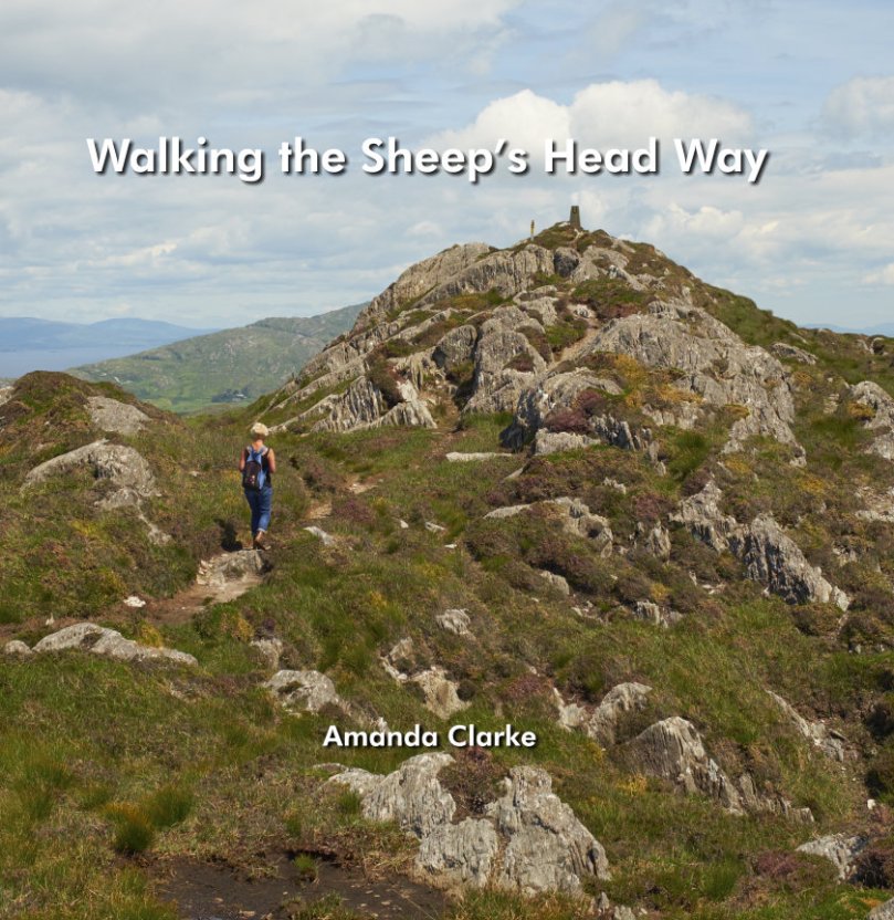
Mount Corrin Walk

View from the cairn, Mount Corrin

View from the cairn, Mount Corrin

Walks that get you up to high places with panoramic views are terrific – especially when you don’t have to start at sea level! One such West Cork walk is Mount Corrin. Despite being on The Mizen, it’s part of the Sheep’s Head Walks system, which means it’s accessible and perfectly waymarked.

P1150782

The whole Mount Corrin loop walk is a 17km marathon and definitely not for the faint-hearted. But faint-hearted is exactly what we are, so we have chosen an option that can be easily accomplished on a pleasant afternoon – about a 5 km round trip. Some of these photographs are from a spring walk, and some from a fine autumn day.

From the trail - the Sheep's Head

From the trail – looking across at the Sheep’s Head

Wear good boots and bring a camera but leave the dog at home as no dogs are allowed on the Sheep’s Head Way. And if you do want to do the Big Walk, we highly recommend you pick up a copy of Walking the Sheep’s Head Way by Amanda Clarke. She and Peter have brought out a Second Edition that includes all the loop walks and they do a fabulous job of describing the whole route and provide wonderful photographs of what you can expect.

This curious little monument is right beside the parking spot

This curious little monument is right beside the parking spot

Our starting point is at a high point about half way between Durrus and Ballydehob. Drive out of Ballydehob via the road between Antonio’s Restaurant and Vincent Coghlan’s pub – that’s the Rathruane Road. About 3 km along this road you will come to a crossroads – turn right. Take the first turn left on that road and it will bring you up to the top of a hill. Once you cross over the top and start the descent on the other side you will see the waters of Dunmanus Bay ahead and to the left and a pull-out for parking on the right.

One of West Cork's most scenic parking spots

One of West Cork’s most scenic parking spots

This is your starting point – look back and you will see the way marked trail about 50ms back up the hill, running alongside a forestry plantation. It’s also your ending point: our walk will take you up to the summit and back.

P1150787

If you’re approaching from Durrus, take the R591 out of the village. Take the first turn left then the first right and follow the road to the summit. These are small country roads – be prepared to pull over or even reverse when you encounter other traffic.

Example of 'other traffic'

Example of ‘other traffic’

Once you set out, the first point of interest is what is described in the National Monuments inventory as a ‘megalithic structure’ and which looks likely to be a wedge tomb, although it is hard to be definitive about it. Whatever it is, it’s man made and intriguing.

A wedge tomb?

A wedge tomb?

You can see the cairn ahead – your destination.

P1040223

Before you get to it there is a row of standing stones. These ones are not marked on the NM inventory but it’s difficult to see what they could be other than a stone alignment. A final push now gets you to the cairn and to those panoramic views we mentioned.

P1040203

The first thing you’ll notice about the cairns (there are two of them) is the size of the large one and the scatter of stones all around them. The consensus seems to be that there has been a cairn on Mount Corrin since ancient times and that the current cairn, a more modern construction, sits on top of an older one.

The cairn on Mount Corrin is visible from this panel of rock art at Rathruane

The cairn on Mount Corrin is visible from this panel of rock art at Rathruane

We have certainly noted that the top of Mount Corrin, like the top of Mount Gabriel, is visible from several prehistoric sites and a cairn would have enhanced that visibility. The most persistent story about the cairn, though, links it to Lord Bandon.

P1040210

The Bernards, Earls of Bandon, are associated with Durrus, having laid out the town in the eighteenth century and having used Durrus Court as a summer residence. They had many interests in the area, including mining, and the always-interesting Durrus History blog gives us this information about Mount Corrin:

Mary Catherine Henrietta Bernard of Castle Bernard daughter of Lord Bandon married Colonel Aldworth on the 30th July 1863 and an address and copy of ‘God’s Holy Word’ was sent by Rev Freke and the tenantry of Durrus to which she returned thanks.  At Dreenlomane Mine (operating until c1920) owned by Lord Bandon, Captain Thomas set tar barrels alight on Mount Corrin which illuminated the sky all night and the 150 miners and their wives were treated to refreshments and similar celebrations were held in Carrigbui.

P1040197

The views from the cairn are stupendous, taking in the West Cork Peninsulas and the hinterland across to the Kerry mountains. Take a while to wander around the top – see if you can spot the collapsed walls of ancient hut sites.

P1040217

Making your way back, look down towards the farms on the northern slope of the mountain. You can still make out the unmistakeable signs of lazy beds, used to grow potatoes, and the ruins of houses abandoned long ago. It’s a poignant reminder that this land was once densely populated by people whose sole nutrition came from potatoes and who fled this area in the aftermath of the Great Famine.

P1040194 - Version 2

There now – that wasn’t gruelling at all, was it? And so rewarding. But still, a bit of effort required so you definitely deserve a coffee and cake at Budd’s, or a pint in Rosie’s. Tell them Roaringwater Journal sent you.

P1040200

A Lick of Paint

blue long distance

What does it mean to say that a house is “set well into the landcape?” On the West Coast of Canada, where I used to live, it usually meant that a house was invisible, often made of wood and blending into the trees. But here in rural West Cork, buildings are more assertive – we ARE the landscape, they seem to say, or at least an important part of it. Therefore we should stand out and be seen. Part of being seen, for many houses in the countryside, is choosing a bright colour. Ah sure, they say, all it needs is a lick of paint.

Crookhaven

Crookhaven


I’ve written before about the colourful towns and villages dotted all over Ireland. Coming around a bend in the road and catching sight of a village is a cheering experience: flashes of colour spread in a line across a backdrop of green fields or rugged mountains. But colour isn’t confined to towns – farmhouses in the deep countryside can suddenly demand attention – pops of colour in a predominantly green terrain. 

Blue seems to be a favourite – and we are not talking here about a pale blue or grey blue. No – duck egg or cobalt blues predominate. The blue is weathering and fading a bit in the house below but it still packs a punch in its isolated setting.

Sometimes blue is used on one side of the house only, or on selective aspects – a gate post or a shutter.

One of my favourites is this house, the colour of a ripe apricot. It is visible from a long way off and always seems to be incandescent on its hillside, as if permanently lit by a setting sun. Close up, I found it has jade green trim, making it even more handsome than it appears from a distance.

apricot distant

That colour is also one of the most recognisable in West Cork because it’s the colour of Jeremy Irons’ Kilcoe Castle. When the castle was being rendered, Irons used a lime mortar in order to waterproof the masonry: the mortar has a distinctive peach tone. Although controversial at the time, it is fair to say that West Cork folk have come to enjoy the sight of this wonderful restored 13th Century castle permanently glowing on its tiny island.

Kilcoe Castle

Kilcoe Castle

Pinks range from soft and pastel to the colour of fuchsia.

I particularly like the pink-on-pink trim of the farmhouse below left, and the candy-coloured house with its blue trim.

Yellow shows up well against a green hill. The first house below belongs to our friends the Camiers, who run the marvellous Gortnagrough Folk Museum. The second one is on the Sheep’s Head (photo by Amanda Clarke).

There are shades of salmon and coral that seem to suit old houses very well. Left, below, is the old school house in Rossbrin, now a private residence, and right is the Ballydehob Rectory, particularly attractive with its green trim.

I’ve found red to be reserved mostly for doors, trim and spot colour, but my friend Amanda Clarke found this old farmhouse on the Sheep’s Head. Take a look at her site, Sheep’s Head Places for examples of vernacular farm buildings. 

Old farmhouse, Sheep's Head

Old farmhouse, Sheep’s Head*

Renovations never stop – I did wonder what colour this one would end up. Now I know!

Going through the spectrum

Going through the spectrum

But this one, unless miracles happen, will see no more paint. Then again, it’s right beside a holy well, so maybe…

Generations of colour

Generations of colour

 *Many thanks to Amanda Clarke for the use of the asterisked photographs

Monoliths, Mysteries and Marriages

"The Fingers" on the skyline

‘The Fingers’ on the skyline

All across West Cork – in the middle of pastureland, in isolated bogs, on the tops of mountains – you see standing stones. Mostly single but also found in pairs, or rows of three or more, they are as ubiquitous as they are mysterious. A scan of the Ordnance Survey map of the valleys running eastwards from Bantry, just north of us, shows a great proliferation of standing stones, and we have been tempted into the field often to hunt for them. We usually find them, but even when we don’t the search brings us into magnificent countryside.

Standing Stone Country

Standing stone country, east of Bantry Bay

The most numerous are, of course, single standing stones. The practice of erecting monoliths dates from the Neolithic and many of the stones we see may indeed be as old as that, or Bronze Age. Some may be medieval or more recent still – local people occasionally have memories of a grandfather placing a stone to act as a cattle scratching post.

Bishop's Luck Stone - wonder what's under this one?

Bishop’s Luck Stone – wonder what’s under this one?

If the stone has rock art on its surface, as is the case with the Burgatia stone near Rosscarbery, for example, we can safely conclude that it’s probably Bronze Age. Ogham incisions, or an inscribed cross will assist with an Early Medieval date. But the vast majority are unmarked and their functions may have varied. Some excavated examples have yielded evidence of burials at the base, and some seem to mark boundaries or entrances to mountain routeways.

Stone pairs and stone rows often occur in close proximity to other Bronze Age monuments such as stone circles and boulder burials. Some are further away from the monument but clearly visible from it.

Like the stone circles, the pair or row has an alignment – generally northeast/southwest, and a further alignment is formed from the two to the boulder burial or stone circle.

Irish folklore is rife with stories about standing stones. Many were said to have been hurled there from a nearby mountain by Finn McCool. Kevin Dannaher in his book Irish Customs and Beliefs relates several instances of petrification. Here’s an example:

…our early saints are…credited with passing fits of choler during which several miscreants were rendered harmless…When St Fiachna discovered that a dairy woman was stealing his butter he did not hesitate to loose a mighty curse against her, which turned not only herself, but her dairy and all her utensils as well, into stone. In proof of which they are still plain to be seen close to the saint’s church at Teampal Fiachna, a few miles south east of Kenmare.

The Three Fingers at Gurranes, near Castletownshend, probably once a row of five or six stones

The Three Fingers at Gurranes, near Castletownshend, probably once a row of five or six stones

One kind of standing stone is particularly intriguing – the holed stone. Tradition has it that these are marriage stones: the couple would join hands through the hole to exchange vows. 

*Both holed stone photographs are by Amanda Clarke

Walking the Sheep’s Head Way

COVER-FRONT

The definitive guide, by Amanda Clarke

NOTE: Since we wrote this post Amanda and Peter have brought out a second edition, including all the loop walks.

This week we attended a very special event – the launch of a new book, Walking the Sheep’s Head Way, written by Amanda Clarke and designed by Peter Clarke. Readers of this blog will be familiar with Amanda and Peter by now, as we have shared many adventures, hikes and explorations with them. 

Amanda and Peter at the launch

Amanda and Peter at the launch

For twelve years now they have been keen photographers and chroniclers of the Sheep’s Head: the book is a natural outgrowth of the passion they have for the peninsula.

Along the north side

Along the north side

Starting and ending in Bantry, the book takes us on the original Sheep’s Head Way, beginning along the north side, out to the lighthouse, and back along the south side. It is divided into 11 sections, each one a separate walk, although they can be combined. Each walk is mapped, and because the Way is so clearly marked, you can’t go wrong. No, really!

Out to the lighthouse!

To the lighthouse!

Amanda has immersed herself in the history, geography, flora, birdlife, archaeology, folklore and landscape of the Sheep’s Head. (Indeed, it is difficult to live here and NOT be fascinated by it all and carried away by the sheer magnificence of the scenery.) Each walk is accompanied by her observations – what to look out for, the meaning of a particular feature, the history of the area, stories of the old days.

As she has done for Robert and me, she leads the reader through the walk as if she’s chatting along beside you like an old friend, filling you in on what’s around you or encouraging you to pause and just listen. 

Abandoned houses at Crimea

Abandoned houses at Crimea

Each walk has its own character – whether it’s a holy well, a famine graveyard, an abandoned settlement, a prehistoric stone circle, old mine workings or signal towers – Amanda provides the essential commentary to enhance your understanding. 

The walks encompass high ridges with sweeping views, cliffhangers with yawning drops to the sea below, soft boggy trails, seaside ambles, and stretches of boreen fringed with wild flowers. 

A ridge walk

A ridge walk

The Sheep’s Head Way has been recognised in Ireland as an area of outstanding natural beauty, and in Europe as a Destination of Excellence (one of the EDENs). And yet, you can walk for miles and never meet another soul, especially in the off season. 

Looking towards the Beara

Looking towards the Beara

If you’re contemplating a holiday in Ireland, or if you’re already here and thinking about dropping down to see us in the Wilds of West Cork, pick up a copy of this book (buy it on Amazon or at one of our great local book shops) pack a pair of stout boots, check out Living the Sheep’s Head Way, and be prepared to be blown away. 

Looking down to Dunmanus Bay

Looking down to Dunmanus Bay

Let us know when to put the kettle on.